
|
KORAMANGALA FLOODS: CAUSES |
| Mismanagement of Landscape: Abuse of Bellandur-Agara wetlands, Narrowing and Concretising RajaKaluve and encroachment of storm water drains, Dumping of solid waste & building debris, Apathy of Civic Agencies |
| T.V. Ramachandra Vinay S Bharath H. Aithal |
|
|
Solution: evict all encroachments to restore and maintain hydrological integrity of valley zones and flood plains
Valley zones: Bangalore has the distinction of having inter connected lake systems. Valley zones connecting two lakes are to be protected to ensure the continuation of hydrological functions of the drains and flood plains. These have been designated as sensitive regions as per the revised master plan 2015 (RMP 2015 of BDA). However, valley zones in Bangalore are being abused despite norms to protect these fragile ecosystems. For example, Pristine Bellandur-Varthur wetland ecosystem has been experiencing threat due to the large scale catchment alterations with changes in the land use land cover. The region forms a part of primary valley, which is sensitive regions as per the revised master plan 2015 (RMP 2015 of BDA). The landscape forms an integral part of the protected area (as it is in valley zone) as per the CDP 2015. This wetlands is now being converted with mixed land use i.e., Built-up with both residential and office complexes. Alterations in the wetland began in 2004 and aggravated post 2008. The alterations of these wetlands initiated by filling the low lying areas with excavated earth debris, followed by other construction activities. The land fillings have breached both rajakaluve and lakes. Rajakaluve have reduced in width from as high as 35m to less than 8 m, apart from the loss of natural stream network connecting the lakes and rajakaluveys. Major violations in Bellandur-Vathur wetlands are:
Figure 5.1 depicts the landscape dynamics in the valley zone between Bellandur and Varthur Lakes. Large scale landscape changes found to occur since 2004, and the process of urbanization is occurring from west to east (Bellandur to Varthur). The wetlands and agriculture lands encompassing 98.5% of the valley zone in 2002 have drastically decreased to 25.68% by the year 2016 which is due to land use conversion for construction (residential/commercial/infrastructure) which has increased from 1.44% in 2002 to 74.32% in 2016. This rampant growth in the valley zone have removed lakes and raja kaluveys that altered the function of natural system of cleansing water, recharging ground water. Table 5.1 highlights extent of landscape alterations and unauthorized occupation of Valley zone.
Figure 5.1: Land use dynamics in Bellandur Varthur Valley Zone
Table 5.1: Land use changes in the valley zone (Virtual Globe: Google earth)
Area in Hectares |
|||||||
Land use / Year |
2002 |
2004 |
2008 |
2010 |
2012 |
2014 |
2016 |
Urban and Soil filling |
5.2 |
20.2 |
135.3 |
141.9 |
212.4 |
243.2 |
271.5 |
Wetland, Agriculture and Water bodies |
360.0 |
345.0 |
230.0 |
223.4 |
152.9 |
122.2 |
93.8 |
Area in Percent |
|||||||
Urban and Soil filling |
1.44 |
5.53 |
37.04 |
38.84 |
58.15 |
66.56 |
74.32 |
Wetland, Agriculture and Water bodies |
98.56 |
94.47 |
62.96 |
61.16 |
41.85 |
33.44 |
25.68 |
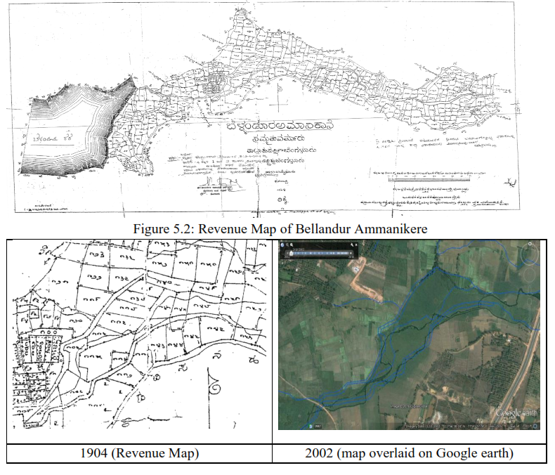
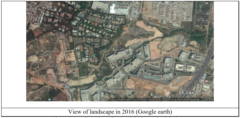
Figure 5.3: Alteration of natural drains and rajakaluveys
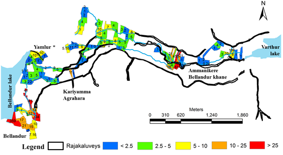
Figure 5.4: Kharab lands in the Valley zone between Bellandur and Varthur lakes
Table 5.2: Kharab lands in the valley zone
Ammanikere Bellandur Khane |
|||||
Survey Number |
Area (Gunta) |
Survey Number |
Area (Gunta) |
Survey Number |
Area (Gunta) |
2 |
1 |
98 |
2 |
168 |
3 |
3 |
1.16 |
99 |
1 |
169 |
2 |
6 |
4 |
106 |
4 |
170 |
2 |
7 |
4 |
107 |
2 |
171 |
6 |
8 |
1 |
108 |
2 |
172 |
5 |
9 |
1 |
116 |
4 |
201 |
1 |
10 |
5 |
117 |
1 |
209 |
3 |
11 |
3 |
120 |
6 |
212 |
3 |
12 |
2 |
124 |
7 |
213 |
21 |
13 |
2 |
125 |
4 |
215 |
4 |
14 |
2 |
126 |
2 |
217 |
4 |
15 |
3 |
127 |
1 |
218 |
18 |
16 |
1 |
128 |
2 |
221 |
61 |
25 |
2 |
140 |
5 |
222 |
21 |
26 |
3 |
141 |
5 |
223 |
55 |
27 |
7 |
142 |
0.16 |
227 |
1 |
30 |
12 |
145 |
9 |
228 |
2 |
31 |
3 |
148 |
5 |
241 |
1 |
38 |
34 |
151 |
4 |
244 |
1 |
39 |
14 |
152 |
10 |
245 |
2 |
42 |
41 |
153 |
10 |
248 |
2 |
53 |
3 |
154 |
3 |
249 |
4 |
54 |
1 |
157 |
7 |
250 |
1 |
55 |
5 |
159 |
4 |
253 |
0.24 |
56 |
1 |
160 |
3 |
256 |
14.08 |
63 |
5 |
161 |
8 |
272 |
10 |
64 |
2 |
162 |
5 |
273 |
3 |
93 |
5.16 |
163 |
1 |
280 |
11 |
94 |
2 |
164 |
3 |
282 |
8 |
96 |
1 |
165 |
5 |
283 |
1 |
97 |
1 |
166 |
2 |
285 |
1 |
Total Area (Guntas) |
570.8 |
||||
Total Area (Acres) |
14.27 |
||||
|
|||||
Bellandur |
Yamlur * |
Kariyamma Agrahara |
|||
Survey Number |
Area (Gunta) |
Survey Number |
Area (Gunta) |
Survey Number |
Area (Gunta) |
4 |
359 |
54 |
20 |
17 |
4 |
8 |
17 |
55 |
1 |
19 |
11 |
10 |
10 |
56 |
10 |
22 |
1 |
11 |
15 |
57 |
1 |
Total (Gunta) |
16 |
13 |
21 |
58 |
3 |
Total(Acre) |
0.4 |
14 |
2 |
59 |
4 |
||
18 |
7.16 |
60 |
2 |
||
Total (Gunta) |
431.16 |
Total (Gunta) |
41 |
||
Total(Acre) |
10.78 |
Total(Acre) |
1.025 |
||
* Verification required |
|||||
Total Area (Guntas) |
1058.96 |
||||
Total Area (Acres) |
26.47 |
||||
Figure 5.2 depicts the revenue map of Bellandur Varthur valley zone (Bellandur Ammanikere). Rampant landscape changes in the valley zone have reduced the width (Figure 5.3) or encroached the natural drainages and rajakaluveys. Rajakaluveys of 25m to 35 m width have reduced in width to less than 5m to 8 m ( example is depicted in Figure 5.9). Figure 5.4 and Table 5.2 details kharab lands in the valley zone between Bellandur and Varthur lake. 1058.96 Guntas (26.47 Acres) of land in the valley zone falls under the category of kharab lands and is distributed in villages of Ammanikere Bellandur Khane, (570.8 Guntas), Bellandur (431.2 Guntas), Kariyamma Agrahara (16 Guntas), Yamlur* (41 Guntas).
Bellandur-Agaram Valley zone: Figure 5.5 depicts the landscape dynamics during 2000 to 2015 (mapped on temporal Google Earth data – http://earth.google.com). The remote sensing data of 2009 – 2015 substantiates the unabated construction activities in the valley zone (without proper compliance and gross violations of environmental norms). Table 5.4 highlights extent of landscape alterations and unauthorized occupation of wetlands (Agara-Bellandur wetland). Figure 5.6 gives cadastral map (1904, scale: 1 in 7920) of the region with land uses - drainage network, agriculture land parcels, tank boundaries, etc.
Table 5.4: Extent of encroachment and illegalities
Year |
wetland |
2007 |
63 Acres 37.5 Guntas |
2010 |
66 Acres 32.3 Guntas |
2012 |
72 Acres 15.9 Guntas |
2013 |
74 Acres 12.1 Guntas |
2015 |
74 Acres 12.1 Guntas |


Figure 5.7 highlights interconnected lake system in Agara-Bellandur region with rajakaluves and stream network. Figure 5.7 also indicates the narrowing down of rajakaluves for the period 2000 to 2015, (for the cross sections A, B, C, D). Rajakauluves have declined between 23% and 57% of the original width during the year 2000 to 2015. Table 5.5 lists applicable various norms for wetlands conservation.
Table 5.5: Various norms for lakes and rajakaluve conservation
Activities around lakes |
Norms to protect and conserve Wetlands |
Encroachment of lake bed and loss of interconnectivity among |
The Hon’ble Supreme Court in Civil appeal number 1132/2011 at SLP (C) 3109/2011 on January 28,2011 has expressed concern regarding encroachment of common property resources, more particularly lakes (and raja kaluves) and it has directed the state governments for removal of encroachments on all community lands. |
Buildings in the buffer zone of lakes |
In case of water bodies, 75.0 m buffer of ‘no development zone’ (as per recent National Green Tribunal direction) is to be maintained around the lake (buffer region to be as per revenue records)
|
Construction activities in the valley zone (SEZ by Karnataka Industrial Areas Development Board (KIADB)) in the valley zone |
This is contrary to sustainable development as the natural resources (lake, wetlands) get affected, eventually leading to the degradation/extinction of lakes. This reflects the ignorance of the administrative machinery on the importance of ecosystems and the need to protect valley zones considering ecological function and these regions are ‘NO DEVELOPMENT ZONES’ as per CDP 2005, 2015 |
Alterations in topography |
Flooding of regions would lead to loss of property and human life and, spread of diseases. |
Increase in deforestation in catchment area |
Removing vegetation in the catchment area increases soil erosion and which in turn increases siltation and decreases transpiration |
Documentation of biodiversity |
|
Implementation of sanitation facilities |
|
Violation of regulatory and prohibitory activities as per Wetlands (Conservation and Management) Rules, 2016 and 2010; |
Environment Impact Assessment (EIA) Notification, 2009.
Prohibited activity
|
Damage of fencing, solid waste dumping and encroachment problems in Varthur lake series
|
High Court of Karnataka (WP No. 817/2008) had passed an order which include:
|
Polluter Pays principle |
National Environment Policy, 2006
|
Prevention of pollution of lake |
National Water Policy, 2002 |
Discharge of untreated sewage into lakes |
The Environment (Protection) Act, 1986
|
The water pollution, prevention and its control measures were not looked upon |
Water (Prevention and Control of Pollution) Act, 1974
The Pollution Control Boards performs the following functions :
|
Pathetic water scenario and insufficient drinking water in Bangalore |
The depletion of ground water and drying up off lakes has affected the water availability to meet the current population. At the 4% population growth rate of Bangalore over the past 50 years, the current population of Bangalore is 8.5 million (2011). Water supply from Hesaraghatta has dried, Thippagondanahalli is drying up, the only reliable water supply to Bangalore is from Cauvery with a gross of 1,410 million liters a day (MLD). There is no way of increasing the drawal from Cauvery as the allocation by the Cauvery Water Disputes Tribunal for the entire urban and rural population in Cauvery Basin in Karnataka is only 8.75 TMC ft (one thousand million cubic – TMC ft equals 78 MLD), Bangalore city is already drawing more water-1,400 MLD equals 18 TMC—than the allocation for the entire rural and urban population in Cauvery basin |
KLCDA Act 2014 |
Acts prohibited in lakes |
| Contact Address : | |||
| Dr. T.V. Ramachandra Energy & Wetlands Research Group, Centre for Ecological Sciences, TE 15, New Biology Building, Third Floor, E Wing, [Near D Gate], Indian Institute of Science, Bangalore – 560 012, INDIA. Tel : 91-80-22933099 / 22933503-extn 107 Fax : 91-80-23601428 / 23600085 / 23600683 [CES-TVR] E-mail : cestvr@ces.iisc.ac.in, energy@ces.iisc.ac.in, Web : http://wgbis.ces.iisc.ac.in/energy |
|||