|
STUDY AREA
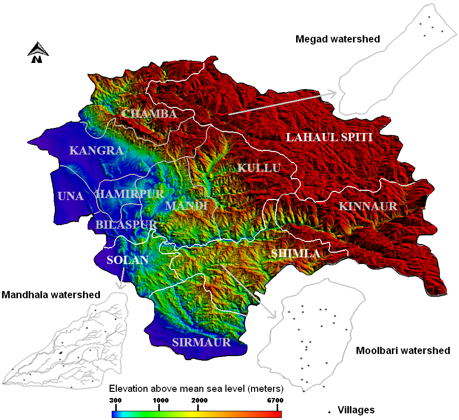
Himachal Pradesh is located between 30.38°– 33.21° North latitudes and 75.77° – 79.07° East longitudes, covering a geographical area of 5.57 million ha with 12 districts [12]. The agro–climatic zones in the state are defined by altitude, climate, soil, precipitation and other geophysical parameters. It has a complex terrain with altitude ranging from 300 to 6700 m as shown by the Digital Elevation Model (DEM) in Figure 1. Almost one–third of the area is snow covered for seven months and forms the origin for many rivers. Regions above 4500 m experience perpetual snowfall and rainfall vary from 50 to 2600 mm along different altitudinal zones [13]. Climate, soil as well as biotic factors in the past (forest fire, shifting agriculture, grazing, etc.) influences the type of vegetation along with other factors like solar radiation, temperature, moisture, geology etc. The major vegetation types found in Himachal Pradesh are tropical, sub–tropical, wet temperate, dry temperate, sub–alpine and alpine, varying with altitudinal gradients and often overlapping due to changes in climate [14].
The study area covers three districts of Solan, Shimla and Lahual Spiti, focusing on three watersheds of Mandhala, Moolbari and Megad inhabiting village clusters (Figure 1). These watersheds and districts are representative of the different agroclimatic zones in the hill state of Himachal Pradesh. The respective watersheds provide village level insight significant for the regional study. The physiographic information of the districts and watersheds are summarized in Table 1.
Table 1: Physiographic information of the study regions
| District |
Altitude (m) |
Area (ha) |
Rainfall (mm) |
Total population (2011) |
Population density (no./km2) |
| Solan |
316 – 2209 |
193600 |
1179–1899 |
576,670 |
298 |
| Shimla |
713 – 4984 |
513100 |
847–1330 |
813,384 |
159 |
| Lahaul Spiti |
2043 – 6514 |
911165 |
332–803 |
31,528 |
2 |
| Watershed |
Latitude (°N) |
Longitude (°E) |
Altitude (m) |
Area (ha) |
River associated |
| Mandhala (Solan) |
30.87–30.97 |
76.82–76.92 |
400–1100 |
1453 |
Yamuna |
| Moolbari (Shimla) |
31.07–31.17 |
77.05–77.15 |
1400–2000 |
1341 |
Yamuna |
| Megad (Lahaul Spiti) |
32.64–32.74 |
76.46–76.74 |
2900–4500 |
1050 |
Chandrabhaga |

Figure 1: Digital Elevation Model (DEM) representing the three districts and village clusters in respective watersheds
Woody biomass
Net Primary Productivity (NPP) of vegetation is the annual increment (t/ha/yr) in total standing biomass of the vegetation. Litterfall includes woody biomass shed from forests including leaves, twigs, branches etc used as fuel wood [15]. The biomass and NPP in Himalayan forests increases from tropical to temperate and then decreases towards alpine [16]. The above ground tree biomass ranges from 80 to 400 t/ha. Litterfall in Central Himalayas for an altitudinal range of 350–2250 m varies between 4.2–7.8 t/ha/yr. Of the litterfall in Himalayan forests, contribution of wood is 9–20% and leaves range between 54–82% [17]. The vegetation types as well as biomass and NPP of representative forests and tree species found in Himalayan terrain are summarized in Table 2 [18–36]. Tropical vegetation dominated by broadleaved tree species is found below 1000 m in major parts of Solan and minor parts of Shimla districts. The tree biomass ranges from 58.7 to 136.1 t/ha and NPP from 5.9 to 22.7 t/ha/yr. Dominance of Lantana Camara weed is noticeable in the hilly tracts degraded by anthropogenic activities. Plantations of Acacia catechu are frequented here. The sub–tropical vegetation found in Solan and Shimla at an altitude range of 900 to 1500 m is characterized by chirpine (Pinus roxburgii) forests. Chirpine has high regeneration potential and caters to the fuel wood needs of the dependants. The vegetation also includes mixed oak forest of Quercus leucotricophora, locally called as Banj oak. The tree biomass of sub–tropical vegetation ranges from 113 to 388 t/ha with NPP of 7.6 to 18.9 t/ha/yr. Beyond the transitional stage of sub–tropical vegetation, wet temperate vegetation is observed in minor parts of Solan and major parts of Shimla districts (1200 to 2500 m). The tree biomass ranges from 146.43 to 782 t/ha with NPP of 15.5 to 28.2 t/ha/yr.Further high, above 2200 m, the wet temperate vegetation gives way to dry temperate and sub–alpine vegetation which are coniferous and dry deciduous in nature. Dry temperate vegetation is found in Shimla and Lahaul Spiti and the tree biomass ranges from 40 to 502 t/ha with NPP of 7.3 to 24.6 t/ha/yr. Above 4000 m (timber limit or tree line) the alpine vegetation favours only short shrub species. Enormous diversity of undergrowths are observed throughout all types of vegetation, however of lesser fuel wood value. The representative fuel wood trees common in these regions with standing biomass and NPP are given in Table 2.
Table 2: Himalayan vegetation types, representative tree species, standing biomass and NPP found in the study regions
| Vegetation |
|
Standing biomass (t/ha) |
NPP (t/ha/yr) |
Ref |
| Tropical |
Forest type |
|
|
|
|
Broadleaved vegetation |
276.79 |
|
[18] |
|
Dry deciduous forest |
– |
14.6–15.7 |
[19] |
|
Tropical seasonal forest |
– |
16 |
[20] |
|
Representative trees |
|
|
|
|
Khair (Acacia catechu ) |
76.35 |
7.63 |
[21] |
|
Poplar (Populus deltoides ) |
– |
5.9–22.7 |
[22] |
|
Bamboo (Dendrocalamus strictus) |
– |
15.8–19.3 |
[23] |
|
Siris (Albizzia lebbeck) |
– |
8.38 |
[24] |
|
Shisham (Dalbergia sissoo) |
58·7– 136·1 |
12·6–20·3 |
[25] |
| Subtropical |
Forest type |
|
|
|
|
Pine forest |
210·8 |
9.9–21.2 |
[26] |
|
" |
115.2–286.2 |
11.0–23 |
[27] |
|
" |
200.8–377.1 |
18.5–24.5 |
[28] |
|
Mixed oak forest |
163.4–432.6 |
14.4–18.9 |
[28] |
|
" |
426 |
15.9 |
[29] |
|
Representative trees |
|
|
|
|
Chirpine (Pinus roxburghii) |
113–283 |
7.6–18.7 |
[29] |
|
" |
117.53 |
18.9 |
[18] |
|
Banj oak (Quercus leucotricophora ) |
388 |
13.2 |
[29] |
| Wet temperate |
Forest type |
|
|
|
|
Oak forest |
197.2–322.8 |
15.9–20.6 |
[30] |
|
Mixed oak |
344 |
15 |
[29] |
|
Representative trees |
|
|
|
|
Oak (Quercus sp.) |
285–782 |
15.5–25.1 |
[29] |
|
Deodar (Cedrus deodara) |
451 |
28.2 |
[29] |
|
" |
146.43 |
|
[18] |
| Dry temperate to subalpine |
Forest type |
|
|
|
|
Temperate decidous forest |
– |
12 |
[20] |
|
Temperate broad leaved forest |
– |
7 – 15.6 |
[31] |
|
Sub alpine forest |
– |
4.76–19.68(ANP) |
[32] |
|
Representative trees |
|
|
|
|
Silver fir (Abies pindrow ) |
– |
18.9 |
[33] |
|
Fir (Abies sp) |
– |
7.3–20.0 |
[33] |
|
Blue pine (Pinus wallichiana) |
– |
13.08. |
[34] |
|
Spruce (Picea sp) |
– |
11–14.0 |
[35] |
|
Maple (Acer sp.) |
– |
10.9 (ANPtree) |
[36] |
|
Horse chestnut (Aesculus indica ) |
502 |
16.5 |
[29] |
|
" |
– |
19.6 |
[33] |
|
Kharsu oak (Quercus semicarpifolia) |
– |
24.6 |
[33] |
|
Birch (Betula utilis) |
172 |
12.5 |
[29] |
|
Rhododendron (Rhododendron sp.) |
40 |
7.5 |
[29] |
Agriculture
Agricultural systems in Himachal Pradesh vary with soil, climate, vegetation as well as socioeconomic factors like market proximity and government intervention. More than 90% of the cropped area in the districts are rain–fed and found on sloping marginal lands and small land holdings. Earlier subsistence based farming system has given way to cash crops and mechanization [13]. Mixed crop–livestock, vegetable based, perennial plantation and agro–pastoral systems are the common farming practices observed here. Including plantations, the net cropped area in Solan, Shimla and Lahaul Spiti are 39370 ha, 67857 ha and 3292 ha respectively [37]. Wheat, maize, rice, pulses and oil seeds are dominant in the tropical and sub–tropical regions, while crops such as millet, barley, buckwheat and dry nuts are common to temperate regions. Fruits and vegetables are profitable, generate more employment and are prominent in regions with access to roads and market. Apple orchards are predominant in wet temperate regions of Solan and Shimla. The sub–tropical and wet temperate regions are reported to be highly productive in terms of crop yield and are largely agriculture intensive. Farmers in dry temperate regions prefer more of mixed type of farming with livestock for sustenance. Due to unfavourable weather conditions agricultural productivity is low in upland cold districts like Lahaul Spiti [1].
Livestock
Livestock includes cattle, buffaloe, yak, mithun (bos frontalis), sheep, goat, horse, pony, mule, donkey, pig and camel which contribute nearly one–fourth of the total household farm income in Himachal Pradesh. Large animals are reared for dairy, draft power, transportation and manure while small animals provide meat, wool etc. Nearly 75–80% households in Himachal Pradesh keep dairy animals and 10% draught animals. The shift to plantation crops as well as mechanization has decreased the demand for draught. It is observed that the number of livestock per household has dwindled in the past few decades. Nevertheless, livestock owners are found to replace low productive cattle and buffaloes with more productive animals [38]. The tropical and subtropical regions have stall–fed and grazed cattle as the major livestock. Wet temperate regions prefer stall–fed cattle while dry temperate regions prefer more of sheep and goats which are grazed in open pastures. Transhumance farming with seasonal migration of people and livestock is observed in Lahaul Spiti and higher reaches of Shimla [1].
Bioenergy consumption
Over 90% of the population in Himachal Pradesh lives in rural areas (17495 villages). Electricity is the source of lighting in nearly 98% of these villages, the others depending on kerosene. Fuel wood satisfies nearly 70% of their heating and cooking needs. Himachal Pradesh is one of the major bioenergy consumer in India with annual fuel wood consumption of 3.2 million tonnes [39]. In rural areas, apart from household heating and cooking, fuel wood is consumed during festivals, marriages, funerals and also burned in margins of agricultural lands to drive away wild animals [40]. Increasing distance for fuel wood collection due to scarcity of forest resources in many cold tribal villages exhaust higher human energy and time [41]. Energy inefficient traditional cook stoves reported thermal efficiency of 8–13% contributing to the indoor pollution affecting women and children [5]. However, improved cook stoves disseminated through the federal program are being used in certain villages of Lahaul Spiti [40]. Certain studies suggest that kerosene and LPG distribution systems are well developed in rural areas while continued availability is not ensured and people are hesitant to switch due to lack of awareness and cost factors [42]. Hence these commercial sources minimally satisfy the rural domestic energy needs.
Fuel wood consumption patterns in different altitudinal gradients were ascertained through field surveys in the three watersheds – Mandhala, Moolbari and Megad apart from comprehensive literature survey of the Western and Central Himalayas given in Table 3 [3, 4, 39–41, 43–47]. The Per Capita Fuel wood Consumption (PCFC) ranges from 0.46 to 4.67 kg/day in Western Himalayas and 1.07 to 2.80 kg/day in Central Himalayas. Eastern Himalayas are the highest consumers of fuel wood reaching even beyond 4 kg/day [2]. Table 3 lists the regional fuel wood consumption studies. It highlights that PCFC in Solan is 0.46 to 1.32 kg/day, Shimla is 1.9 to 2.68 kg/day and Lahaul Spiti is 0.89 to 2.91 kg/day. This increase in consumption pattern along the altitudinal gradient is conspicuous due to higher demand for space and water heating in colder regions. This altitude based variation is observed irrespective of socioeconomic conditions. However, within an altitudinal range, large families consume less fuel wood per capita compared to smaller ones [40, 41].
Table 3: Fuel wood consumption patterns in different altitudinal gradients of Western and Central Himalayas
| Region |
PCFC (kg/day) |
Elevation |
Reference |
| Western Himalaya |
|
|
|
| Himachal Pradesh (Rural areas) |
1.562 |
300–6700 |
[39] |
| Mandhala watershed, Solan |
0.68±0.22 |
400–1100 |
Present study (ground survey) |
| Moolbari watershed, Shimla |
1.9–2.63 |
1400–2000 |
Present study (ground survey) |
| Megad waterhed, Lahaul Spiti |
1.53±0.64 |
2900–4500 |
Present study (ground survey) |
| Solan district, Himachal Pradesh (HP) |
1.32 |
316 – 2209 |
[3] |
| Shimla district, Himachal Pradesh |
2.68 |
713 – 4984 |
[3] |
| Mandi district, Himachal Pradesh |
2.99 |
– |
[3] |
| Kullu valley |
4.3±0.37 |
1200–1400 |
[43] |
| Hill forest (rural areas) |
1.89 |
– |
[44] |
| Hill forest (urban areas) |
1.21 |
– |
[44] |
| Hill non–forest (rural areas), HP |
1.31 |
– |
[44] |
| Khoksar, Lahaul Valley |
1.06–3 |
3200 |
[40] |
| Jahlma, Lahaul Valley |
1.02–2.91 |
3000 |
[40] |
| Hinsa, Lahaul Valley |
0.98–2.74 |
2700 |
[40] |
| Kuthar, Lahaul Valley |
0.91–2.68 |
2600 |
[40] |
| Central Himalaya |
|
|
|
| Garhwal Himalaya |
1.07–2.80 |
380–2500 |
[41] |
| Garhwal Himalaya, Tehri |
1.12–2.44 |
500–2500 |
[45] |
| Garhwal, tropical |
2.42–2.52 |
300–400 |
[4] |
| Garhwal, sub–tropical |
1.63–1.7 |
900–1300 |
[4] |
| Garhwal, temperate |
1.77–2.32 |
1900–2400 |
[4] |
| Kumaon Himalaya |
1.49 |
– |
[46] |
| Nepal Himalaya |
1.23 |
– |
[47] |
|