|
RESULTS AND ANALYSIS
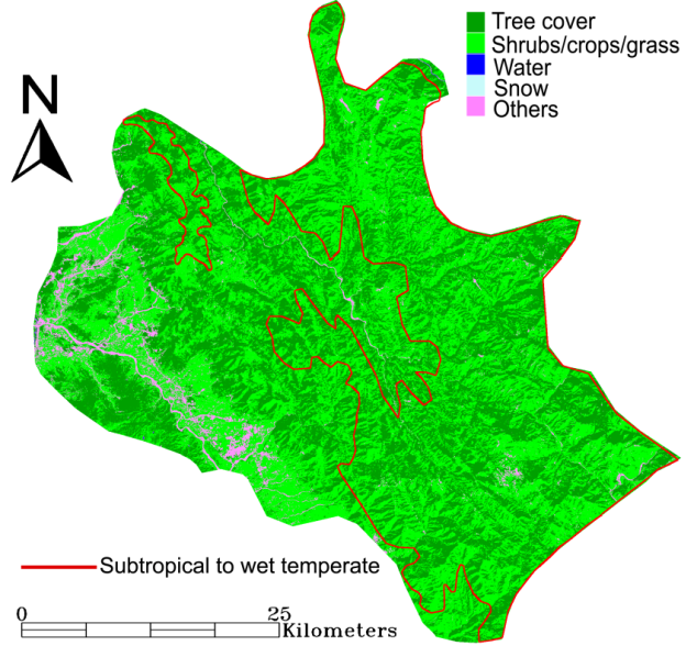
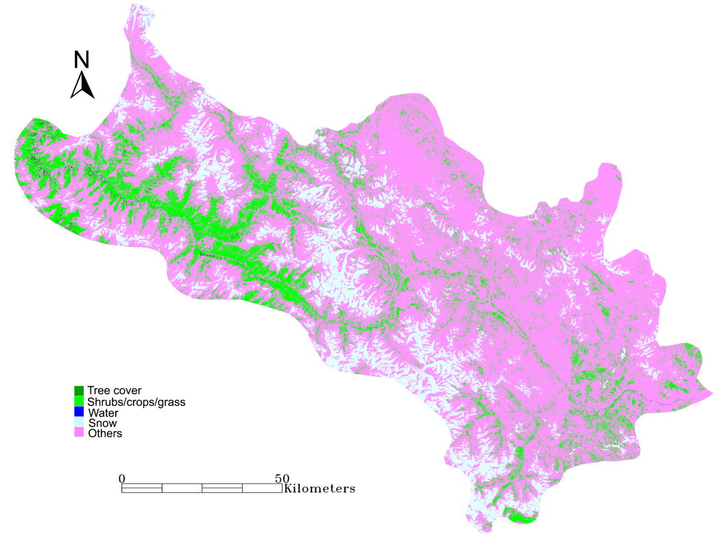
LCLU analyses of Solan, Shimla and Lahaul Spiti districts are performed and the types of vegetation are identified spatially (Figures 4a–c). The temporal land cover changes for the districts are given in Table 6. Based on analysis of the latest available spatial data (2005/06), the total tree cover in Solan is 43.51%, Shimla is 48.85% and Lahaul Spiti is 0.36% of the respective total geographic areas (Table 7). The ANPtree estimated for the vegetation types are given in Table 8. The annual woody biomass produced ranges as 517.3–1111.7, 1253.8–3029.8, and 18.9–63.8 kilo tonnes for Solan, Shimla and Lahaul Spiti districts respectively. The lower, moderate and uppercase scenarios of availability are listed in Table 9. In all cases, the total availability of woody biomass is the highest in Shimla, followed by Solan and Lahaul Spiti. The district–wise fuel wood demand for lower, moderate and upper PCFC cases is given in Table 10. PCFC in Solan is 0.48–1.32 kg/person/day, Shimla is 1.9–2.68 and Lahaul Spiti is 0.89–2.91 kg/person/day. Evidently, the higher case of fuel wood demand in Lahaul Spiti cannot be met even by the moderate case productivity of woody biomass in the region. Moreover, the actual availability of woody biomass as fuel wood considering its alternative use as timber is lower than the total productivity in any region. Hence practically available fuel wood may not meet the bioenergy requirements of these regions for different demand cases.
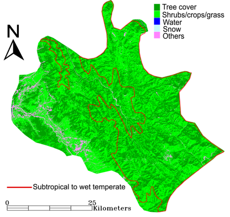
Figure 4a: Land cover classification of 2005/06 satellite image with vegetation type identified for Solan
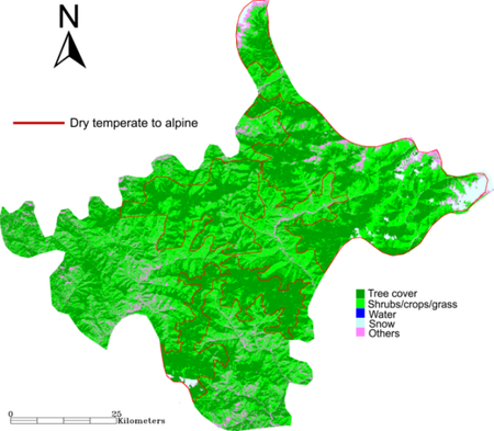
Figure 4b: Land cover classification of 2005/06 satellite image with vegetation type identified for Shimla

Figure 4c: Land cover classification of 2005/06 satellite image for Lahaul Spiti
Table 6: GMLC based temporal land cover classification results for Solan, Shimla and Lahaul Spiti
| District |
Year |
Tree cover |
Shrubs/crops/grass |
Water |
Snow |
Others |
|
|
ha |
% |
ha |
% |
ha |
% |
ha |
% |
ha |
% |
| Solan |
1989 |
97665.43 |
47.70 |
101291.19 |
49.47 |
24.37 |
0.01 |
0.00 |
0.00 |
5774.69 |
2.82 |
| 2000 |
94508.19 |
46.02 |
102382.68 |
49.85 |
24.39 |
0.01 |
0.00 |
0.00 |
8469.95 |
4.12 |
| 2005 |
89354.01 |
43.51 |
107318.57 |
52.26 |
26.28 |
0.01 |
0.00 |
0.00 |
8669.05 |
4.22 |
| Shimla |
1989 |
249589.62 |
52.55 |
190807.40 |
40.17 |
10.88 |
0.00 |
9373.37 |
1.97 |
25176.71 |
5.30 |
| 2000 |
232780.26 |
48.98 |
191295.96 |
40.25 |
28.98 |
0.01 |
9092.59 |
1.91 |
42074.63 |
8.85 |
| 2005 |
231767.28 |
48.85 |
189457.75 |
39.93 |
1.44 |
0.00 |
9499.76 |
2.00 |
43766.50 |
9.22 |
| Lahaul Spiti |
1989 |
7215.61 |
0.51 |
166665.31 |
11.67 |
290.46 |
0.02 |
253642.97 |
17.77 |
999896.33 |
70.03 |
| 2000 |
8060.11 |
0.56 |
226480.31 |
15.86 |
478.74 |
0.03 |
216714.47 |
15.18 |
976327.38 |
68.37 |
| 2005 |
5187.92 |
0.36 |
203383.35 |
14.24 |
497.75 |
0.03 |
200516.52 |
14.04 |
1018475.48 |
71.32 |
Table 7: Types of vegetation identified and extent of tree cover (in hectares) mapped in different districts
| District |
Tropical to subtropical |
Wet temperate |
Dry temperate to subalpine |
Total |
| Solan |
40051.97 |
49302.04 |
0.00 |
89354.01 |
| Shimla |
0.00 |
99474.43 |
132292.85 |
231767.28 |
| Lahaul Spiti |
0.00 |
0.00 |
5187.92 |
5187.92 |
Table 8: The lower, moderate and upper case ANPtree (t/ha/yr) values of different vegetation
| Scenario |
Tropical to subtropical |
Wet temperate |
Dry temperate to subalpine |
| Lower case |
3.375 |
7.75 |
3.65 |
| Moderate case |
6.8875 |
10.93 |
7.98 |
| Upper case |
10.4 |
14.10 |
12.30 |
Table 9: Woody biomass availability (kilo t/yr) from different vegetation types of three districts for lower, moderate and upper case ANPtree
| District |
Scenario |
Tropical to subtropical |
Wet temperate |
Dry temperate to subalpine |
Total |
| Solan |
Lower case |
135.18 |
382.09 |
0.00 |
517.27 |
|
Moderate case |
275.86 |
538.62 |
0.00 |
814.48 |
|
Upper case |
416.54 |
695.16 |
0.00 |
1111.70 |
| Shimla |
Lower case |
0.00 |
770.93 |
482.87 |
1253.80 |
|
Moderate case |
0.00 |
1086.76 |
1055.04 |
2141.79 |
|
Upper case |
0.00 |
1402.59 |
1627.20 |
3029.79 |
| Lahaul Spiti |
Lower case |
0.00 |
0.00 |
18.94 |
18.94 |
|
Moderate case |
0.00 |
0.00 |
41.37 |
41.37 |
|
Upper case |
0.00 |
0.00 |
63.81 |
63.81 |
Table 10: PCFC estimated and total fuel wood demand for different scenarios in three districts projected for the year 2006
| District |
Scenario |
PCFC (kg/day) |
Total fuel wood demand (kilo tonnes/yr) |
| Solan |
Lower case |
0.46 |
97.50 |
|
Moderate case |
0.89 |
188.65 |
|
Higher case |
1.32 |
279.79 |
| Shimla |
Lower case |
1.9 |
544.28 |
|
Moderate case |
2.29 |
656.00 |
|
Higher case |
2.68 |
767.72 |
| Lahaul |
Lower case |
0.89 |
11.13 |
|
Moderate case |
1.9 |
23.76 |
|
Higher case |
2.91 |
36.39 |
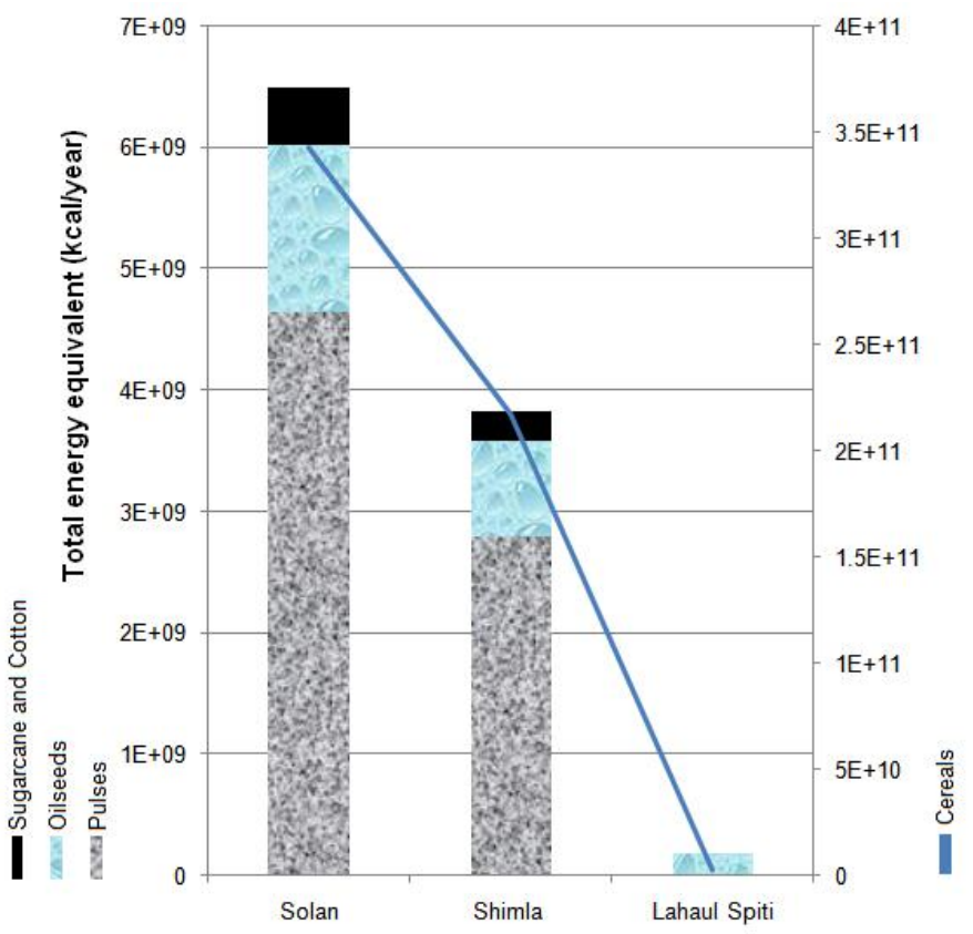
The annual bioenergy equivalent of agro residues (from cereals, pulses, oilseeds, cotton and sugarcane) in Solan is 698925 million kcal, Shimla is 443124 million kcal and Lahaul Spiti is 5356 million kcal. However, we have considered only 50% of the agro residues available for energy purposes (fuel ratio). The total annual production of agro residues and agro bioenergy availability in the three districts are given in Table 11. Figure 5 shows that total annual bioenergy from agro–residues is the highest in Solan and least in Lahaul Spiti. Cereals and oilseeds are the only sources of agro bioenergy in Lahaul Spiti. Among all crops, cereals have the highest bioenergy potential in all districts, followed by pulses.
Table 11: Area, residue production and energy equivalent for different crops in Solan, Shimla and Lahaul Spiti
| |
|
|
Solan |
Shimla |
Lahaul Spiti |
| CROP |
NAME |
Residue type |
Area (ha) |
Residue produced (t/yr) |
Energy equivalent (kcal/yr) |
Area (ha) |
Residue produced (t/yr) |
Energy equivalent (kcal/yr) |
Area (ha) |
Residue produced (t/yr) |
Energy equivalent (kcal/yr) |
| CEREALS |
Rice |
Husk |
4742 |
2530 |
4.00E+09 |
1981 |
586 |
9.00E+08 |
0 |
0 |
0 |
| Stalk |
13088 |
2.00E+10 |
3031 |
5.00E+09 |
0 |
0 |
| Wheat |
Stalk |
24694 |
58080 |
1.00E+11 |
15104 |
24891 |
4.00E+10 |
81 |
183 |
3.00E+08 |
| Bajra |
Cobs |
0 |
0 |
0 |
3 |
1 |
1.00E+06 |
0 |
0 |
0 |
| Husk |
0 |
0 |
1 |
1.00E+06 |
0 |
0 |
| Stalk |
0 |
0 |
5 |
9.00E+06 |
0 |
0 |
| Maize |
Cobs |
22852 |
12290 |
2.00E+10 |
13896 |
8763 |
2.00E+10 |
64 |
39 |
7.00E+07 |
| Husk |
9004 |
1.00E+10 |
6420 |
1.00E+10 |
28 |
4.00E+07 |
| Stalk |
90037 |
2.00E+11 |
64200 |
1.00E+11 |
283 |
6.00E+08 |
| Barley |
Stalk |
1682 |
1880 |
3.00E+09 |
4704 |
6054 |
9.00E+09 |
592 |
939 |
1.00E+09 |
| Others |
Stalk |
0 |
0 |
0 |
4049 |
4195 |
6.00E+09 |
107 |
60 |
9.00E+07 |
| PULSES |
Gram |
Stalk |
315 |
305 |
5.00E+08 |
29 |
33 |
6.00E+07 |
0 |
0 |
0 |
| Tur/arhar |
Husk |
0 |
0 |
0 |
70 |
4 |
6.00E+06 |
0 |
0 |
0 |
| Stalk |
0 |
0 |
35 |
5.00E+07 |
0 |
0 |
| Kharif |
Husk |
1695 |
232 |
3.00E+08 |
4416 |
215 |
3.00E+08 |
27 |
1 |
2.00E+06 |
|
Stalk |
1417 |
2.00E+09 |
1312 |
2.00E+09 |
8 |
1.00E+07 |
| Rabi |
Stalk |
908 |
730 |
1.00E+09 |
48 |
32 |
6.00E+07 |
0 |
0 |
0 |
| OILSEEDS |
Groundnut |
Shell |
14 |
4 |
8.00E+06 |
8 |
1 |
1.00E+06 |
0 |
0 |
0 |
| Stalk |
25 |
5.00E+07 |
4 |
8.00E+06 |
0 |
0 |
| Sesamum |
Stalk |
320 |
96 |
1.00E+08 |
40 |
13 |
2.00E+07 |
0 |
0 |
0 |
| Rapeseed & Mustard |
Husk & Stalk |
414 |
304 |
5.00E+08 |
601 |
361 |
6.00E+08 |
68 |
96 |
2.00E+08 |
| Soyabeen |
Stalk |
46 |
107 |
2.00E+08 |
39 |
89 |
1.00E+08 |
0 |
0 |
0 |
| Others |
Stalk |
684 |
274 |
5.00E+08 |
7 |
3 |
5.00E+06 |
0 |
0 |
0 |
| MISCELLANEOUS |
Cotton |
Shell & husk |
53 |
84 |
1.00E+08 |
0 |
0 |
0 |
0 |
0 |
0 |
| Stalk |
159 |
2.00E+08 |
159 |
2.00E+08 |
0 |
0 |
| Sugarcane |
Bagasse |
189 |
54 |
9.00E+07 |
0 |
0 |
0 |
0 |
0 |
0 |
| Top & leaves |
8 |
1.00E+07 |
0 |
0 |
0 |
0 |

Figure 5: Total energy equivalent of agro residues produced in Solan, Shimla and Lahaul Spiti
Table 12 gives the different cases of dung yield from livestock found in Himachal Pradesh. Considering the moderate case of dung yield, total dung generation is the highest in Shimla and least in Lahaul Spiti. Cattles, buffaloes and goats are the major sources of animal dung in Solan and contributes nearly 615.3 kilo tonnes annually. Since these are mostly stall fed, the actual availability is higher in the district. Apart from these animals, Shimla has additional livestock varieties of sheep, horses and mules, together generating 778.7 kilo tonnes of dung annually. The cold district of Lahaul Spiti has cattle, yak, sheep, buffaloe, goat and horses generating 36.6 kilo tonnes of annual dung. Total annual dung yield from livestock, their biogas generation potential and energy equivalents are estimated for lower, moderate and upper case dung yield values (Table 13). The annual biogas generation in Solan is 8.7–35.6 million m3, Shimla is 12.9–43.2 million m3 and Lahaul Spiti is 0.8–1.9 million m3.
Table 12: Lower, moderate and upper case dung yield (kg/head/day) considered for livestock
| Livestock |
Cattle |
Buffaloe |
Yak |
Mithun |
Sheep |
Goat |
Horse |
Pony |
Mule |
Donkey |
Pig |
Camel |
| Lower case |
2.87 |
2.65 |
4.50 |
4.50 |
0.10 |
0.10 |
1.72 |
1.72 |
0.94 |
0.94 |
0.34 |
2.49 |
| Moderate case |
6.44 |
8.83 |
4.50 |
4.50 |
0.21 |
0.23 |
3.90 |
3.90 |
0.94 |
0.94 |
0.34 |
2.49 |
| Upper case |
10.00 |
15.00 |
4.50 |
4.50 |
0.35 |
0.35 |
6.08 |
6.08 |
0.94 |
0.94 |
0.34 |
2.49 |
Table 13: Livestock types, biogas generation and energy equivalent for different dung yield scenarios (L–lower case, M–Moderate case, U–Uppercase) in Solan, Shimla and Lahaul Spiti
|
|
Solan |
Shimla |
Lahaul Spiti |
| Livestock |
|
Total dung (kg/yr) |
Biogas (m3/yr) |
Energy equivalent (kcal/yr) |
Total dung (kg/y) |
Biogas (m3/yr) |
Energy equivalent (kcal/y) |
Total dung (kg/y) |
Biogas (m3/yr) |
Energy equivalent (kcal/y) |
| Cattle |
L |
2.E+08 |
5.E+06 |
3.E+10 |
3.E+08 |
1.E+07 |
6.E+10 |
1.E+07 |
5.E+05 |
2.E+09 |
| M |
3.E+08 |
1.E+07 |
6.E+10 |
7.E+08 |
3.E+07 |
1.E+11 |
3.E+07 |
1.E+06 |
5.E+09 |
| U |
5.E+08 |
2.E+07 |
9.E+10 |
1.E+09 |
4.E+07 |
2.E+11 |
4.E+07 |
2.E+06 |
8.E+09 |
| Buffaloe |
L |
8.E+07 |
3.E+06 |
1.E+10 |
1.E+07 |
5.E+05 |
2.E+09 |
0 |
0 |
0 |
| M |
3.E+08 |
1.E+07 |
5.E+10 |
4.E+07 |
2.E+06 |
8.E+09 |
0 |
0 |
0 |
| U |
5.E+08 |
2.E+07 |
8.E+10 |
7.E+07 |
3.E+06 |
1.E+10 |
0 |
0 |
0 |
| Yak |
L |
0 |
0 |
0 |
3.E+04 |
1.E+03 |
5.E+06 |
2.E+06 |
8.E+04 |
4.E+08 |
| M |
0 |
0 |
0 |
3.E+04 |
1.E+03 |
5.E+06 |
2.E+06 |
8.E+04 |
4.E+08 |
| U |
0 |
0 |
0 |
3.E+04 |
1.E+03 |
5.E+06 |
2.E+06 |
8.E+04 |
4.E+08 |
| Mithun |
L |
0 |
0 |
0 |
0 |
0 |
0 |
3.E+03 |
1.E+02 |
6.E+05 |
| M |
0 |
0 |
0 |
0 |
0 |
0 |
3.E+03 |
1.E+02 |
6.E+05 |
| U |
0 |
0 |
0 |
0 |
0 |
0 |
3.E+03 |
1.E+02 |
6.E+05 |
| Sheep |
L |
3.E+05 |
1.E+04 |
5.E+07 |
1.E+07 |
4.E+05 |
2.E+09 |
4.E+06 |
2.E+05 |
8.E+08 |
| M |
2.E+05 |
7.E+03 |
3.E+07 |
7.E+06 |
3.E+05 |
1.E+09 |
3.E+06 |
1.E+05 |
5.E+08 |
| U |
9.E+04 |
3.E+03 |
2.E+07 |
3.E+06 |
1.E+05 |
6.E+08 |
1.E+06 |
5.E+04 |
2.E+08 |
| Goat |
L |
1.E+07 |
4.E+05 |
2.E+09 |
1.E+07 |
4.E+05 |
2.E+09 |
1.E+06 |
4.E+04 |
2.E+08 |
| M |
7.E+06 |
2.E+05 |
1.E+09 |
8.E+06 |
3.E+05 |
1.E+09 |
7.E+05 |
2.E+04 |
1.E+08 |
| U |
3.E+06 |
1.E+05 |
5.E+08 |
3.E+06 |
1.E+05 |
6.E+08 |
3.E+05 |
1.E+04 |
6.E+07 |
| Horse |
L |
2.E+05 |
7.E+03 |
3.E+07 |
7.E+05 |
2.E+04 |
1.E+08 |
1.E+04 |
4.E+02 |
2.E+06 |
| M |
4.E+05 |
2.E+04 |
8.E+07 |
2.E+06 |
6.E+04 |
3.E+08 |
2.E+04 |
9.E+02 |
4.E+06 |
| U |
7.E+05 |
2.E+04 |
1.E+08 |
2.E+06 |
9.E+04 |
4.E+08 |
4.E+04 |
1.E+03 |
7.E+06 |
| Pony |
L |
3.E+04 |
1.E+03 |
6.E+06 |
6.E+05 |
2.E+04 |
1.E+08 |
6.E+05 |
2.E+04 |
1.E+08 |
| M |
8.E+04 |
3.E+03 |
1.E+07 |
1.E+06 |
5.E+04 |
2.E+08 |
1.E+06 |
5.E+04 |
2.E+08 |
| U |
1.E+05 |
4.E+03 |
2.E+07 |
2.E+06 |
8.E+04 |
4.E+08 |
2.E+06 |
8.E+04 |
4.E+08 |
| Mule |
L |
3.E+05 |
9.E+03 |
5.E+07 |
1.E+06 |
3.E+04 |
2.E+08 |
0 |
0 |
0 |
| M |
3.E+05 |
9.E+03 |
5.E+07 |
1.E+06 |
3.E+04 |
2.E+08 |
0 |
0 |
0 |
| U |
3.E+05 |
9.E+03 |
5.E+07 |
1.E+06 |
3.E+04 |
2.E+08 |
0 |
0 |
0 |
| Donkey |
L |
6.E+04 |
2.E+03 |
1.E+07 |
3.E+05 |
1.E+04 |
5.E+07 |
7.E+05 |
2.E+04 |
1.E+08 |
| M |
6.E+04 |
2.E+03 |
1.E+07 |
3.E+05 |
1.E+04 |
5.E+07 |
7.E+05 |
2.E+04 |
1.E+08 |
| U |
6.E+04 |
2.E+03 |
1.E+07 |
3.E+05 |
1.E+04 |
5.E+07 |
7.E+05 |
2.E+04 |
1.E+08 |
| Pig |
L |
2.E+04 |
9.E+02 |
4.E+06 |
3.E+04 |
1.E+03 |
5.E+06 |
0 |
0 |
0 |
| M |
2.E+04 |
9.E+02 |
4.E+06 |
3.E+04 |
1.E+03 |
5.E+06 |
0 |
0 |
0 |
| U |
2.E+04 |
9.E+02 |
4.E+06 |
3.E+04 |
1.E+03 |
5.E+06 |
0 |
0 |
0 |
| Camel |
L |
9.E+02 |
3.E+01 |
2.E+05 |
3.E+03 |
1.E+02 |
5.E+05 |
0 |
0 |
0 |
| M |
9.E+02 |
3.E+01 |
2.E+05 |
3.E+03 |
1.E+02 |
5.E+05 |
0 |
0 |
0 |
| U |
9.E+02 |
3.E+01 |
2.E+05 |
3.E+03 |
1.E+02 |
5.E+05 |
0 |
0 |
0 |
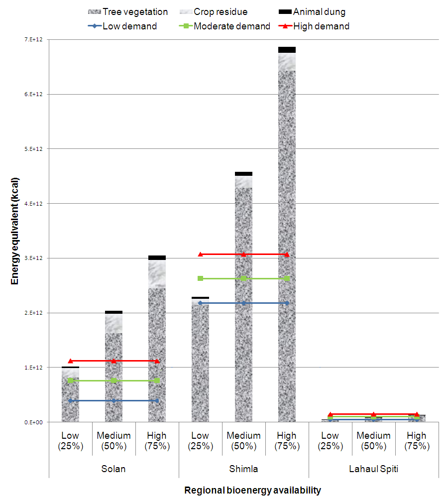
Considering the multiple uses of woody biomass, agro residues and animal dung, the actual availability of these bioresources for fuel purposes are accounted in high (75%), medium (50%) and low (25%) supply scenarios. Figure 6 highlights these bioenergy availability scenarios (considering moderate case production for woody biomass and animal dung) and their prospects of meeting the lower, moderate and upper case bioenergy demands in the three districts. The bioenergy resource status of the three districts are represented in Figure 7.
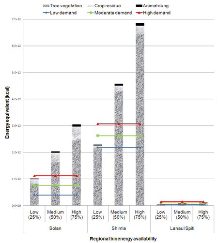
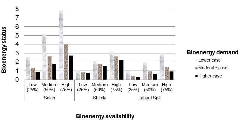
Figure 6: Different availability scenarios of bioenergy resources and cases of bioenergy demand in Solan, Shimla and Lahaul Spiti
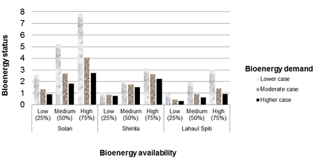
Figure 7: Bioenergy resource status of Solan, Shimla and Lahaul Spiti
In solan, higher case bioenergy demand cannot be met by the low (25%) bioenergy availability scenario even after including agro residues and biogas energy from animal dung. This scenario points at a bioenergy deficit status for the region (Figure 7). However, moderate and lower case demand is being met by the fuel wood resources. In Shimla, even lower case bioenergy demand is met by the low (25%) availability scenario of woody biomass. Additional bioenergy from agro and animal residues (low) fail to meet the moderate and higher case demand. As seen in Figure 7, this scenario represents a critical bioenergy status for Shimla. However, medium (50%) availability of woody biomass is sufficient for a higher case demand. In Lahaul Spiti, high (75%) availability of woody biomass sustains at least moderate case demand, while medium (50%) availability sustains only lower case demand. Even a high total bioenergy availability scenario, cannot sustain the higher case demand of the region. This indicates a very critical bioenergy deficit status in the cold district of Lahaul Spiti.
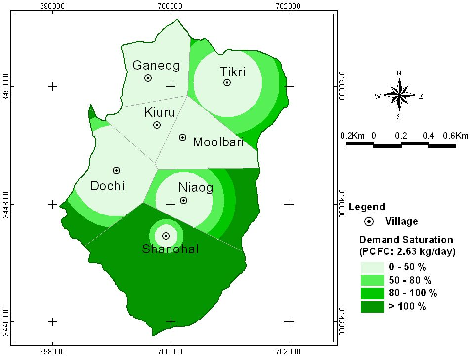
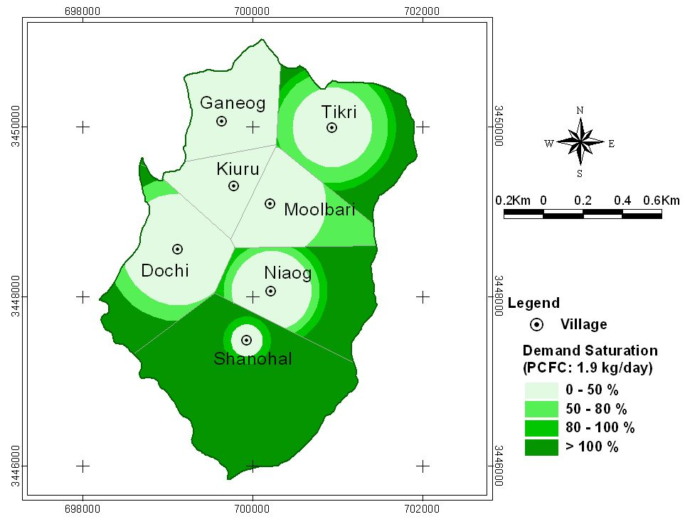
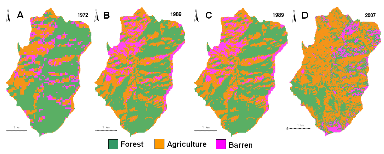
Figures 8a and 8b represent biomass saturation in the proximity of 7 villages in Moolbari watershed for higher (2.63 kg/day) and lower (1.9 kg/day) case bioenergy demand scenarios respectively. It is observed that the villages of Moolbari, Ganeog, Kiuru and Dochi have limited availability of fuel wood resource in their vicinity and people traverse longer distances to meet their needs. The villages of Tikri and Niaog have relatively higher fuel wood availability while Shanohal has the highest among all. The forest fragmentation study conducted in the same watershed reveals the extent of forest degradation that has occurred from 1972 to 2007 (Figure 9a). The overall accuracy of image classification is between 81–89% and results show that the extents of forest cover which was high in 1972 eventually declined by 5.59% in 2007. It is observed that the regions prone to higher forest fragmentation levels inhabit villages like Moolbari, Ganeog, Kiuru and Dochi with lower biomass saturation. This highlights the anthropogenic influence in forest fragmentation occurred over a period of time. A similar analysis of the tree cover changes in Mandhala watershed during the period 1972 to 2007 also exposes the forest fragmentation in its landscape (Figure 9b). Such grassroots level resource constraints are not discerned in the district level bioresource assessment and hence call for further disaggregation in assessment studies.

Figure 8a: Bio–mass saturation map for Moolbari, Case–I
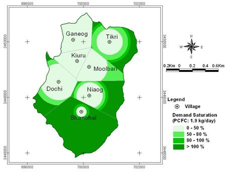
Figure 8b: Bio–mass saturation map for Moolbari, Case–II
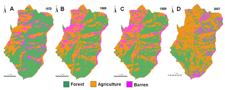
Figure 9a: Classified images of Mandhala watershed showing land cover and land use changes from 1972 to 2007
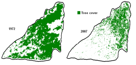
Figure 9b: Tree cover change from 1972 to 2007 in Mandhala watershed
|