http://www.iisc.ernet.in/
Groundwater quality impairment due to mismanagement of biodegradable waste
http://wgbis.ces.iisc.ernet.in/energy/
1Energy and Wetlands Research Group, Centre for Ecological Sciences [CES],
2Centre for Sustainable Technologies, 3Centre for infrastructure, Sustainable Transportation and Urban Planning (CiSTUP),
Indian Institute of Science, Bangalore – 560012, India.
*Corresponding author:
cestvr@ces.iisc.ernet.in

MATERIALS AND METHODS

Study area

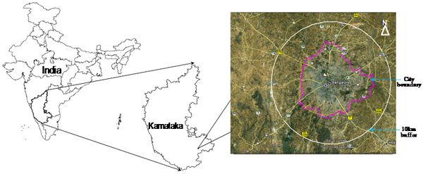
Bangalore city is situated within the latitudes 12°39’00’’ to 13°13’00’’ N and longitudes 77°22’00’’ to 77°52’00’’ E covering an area of 741 km2. Bangalore city population has increased enormously from 65,37,124 (in 2001) to 95,88,910 (in 2011), accounting for 46.68 % growth in a decade. Population density has increased from as 10732 (in 2001) to 13392 (in 2011) persons per sq. km [1]. Rapid urbanization in recent times has led to 632% increase in builtup area (from 1973 to 2010) and the loss of 78% water bodies and 76% vegetation cover [1]. Sewage generated in the city is either untreated or partially treated that finally gets into these water bodies leading to the enrichment of nutrients due to the sustained inflow. Bangalore city, one among the five metros in India. About 60% of the MSW collected was dumped at unauthorized dumpsites located around Bangalore. A 10km buffer was considered around the city to account peri-urban area with illegal open dumps (Fig 1).


Fig 1: Study area Bangalore city boundary

Data collection and sources

The work was involved collection of data through experiments, government agencies and spatial analysis of compiled data using geographic information system (GIS). Field survey was conducted in the year 2011-2012 to i) find open dumpsites and ii) check the drainage blockages due to clogging of waste. GPS (Global Positioning System) was used to capture the dumpsite locations.

A random sampling method was used for field observations of solid waste dumps. A total 62 open dumpsites and 93 locations of drainage channels were surveyed. These open dumpsites were located at peri-urban areas in the peripheral area of the city (Fig 2). Simultaneously, each of the sites was photographed using a digital camera apart from quantification of organic fraction of waste. These dumpsite locations were spatially analysed using GIS [19]. 33 water bodies were chosen for the current analysed and most of them have been receiving sewage since long time (Fig 3). Water quality values of groundwater wells located in the close proximity (<250m) of sewage fed lake or open dumpsites were assessed.  Nitrate level for water bodies located closer to open dumpsites were compiled from various literatures [20, 21, 22]. All spatial analyses were performed with Mapinfo software 7.4.

BACK  «  TOP  »  NEXT
Citation : Ramachandra, T.V.; Shwetmala, "Groundwater quality impairment due to mismanagement of biodegradable waste," Global Humanitarian Technology Conference: South Asia Satellite (GHTC-SAS), 2013 IEEE , vol., no., pp.223,227, 23-24 Aug. 2013. doi: 10.1109/GHTC-SAS.2013.6629920.
* Corresponding Author :
Dr. T.V. Ramachandra
Energy & Wetlands Research Group, Centre for Ecological Sciences, Indian Institute of Science, Bangalore – 560 012, India.
Tel : +91-80-2293 3099/2293 3503 [extn - 107],      Fax : 91-80-23601428 / 23600085 / 23600683 [CES-TVR]
E-mail : cestvr@ces.iisc.ernet.in, energy@ces.iisc.ernet.in,     Web : http://wgbis.ces.iisc.ernet.in/energy, http://ces.iisc.ernet.in/grass
E-mail    |    Sahyadri    |    ENVIS    |    GRASS    |    Energy    |      CES      |      CST      |    CiSTUP    |      IISc      |    E-mail