 |
Landslides in coastal Uttara Kannada: Management towards risk reduction |
Energy & Wetlands Research Group, Centre for Ecological Sciences, Indian Institute of Science, Bangalore 560 012, India
E mail: cestvr@ces.iisc.ac.in, mds@ces.iisc.ac.in
Karwar Landslides
On 2nd October, 2009, on an exceptionally high rainy day (423.6 mm recorded on 3rd morning) 21 landslides of varied intensities struck the coastal hills of Karwar towards the centre of Indian west coast. Karwar is a taluk in the Uttara Kannada district (formerly North Kanara) of coastal Karnataka and also the district headquarters (Figures 1 & 2 for topography and important landslide locations). Flanked by the Arabian Sea to the west, most of Uttara Kannada’s low altitude (seldom exceeding 600 m) hilly terrain receives heavy monsoon downpour from 3000-5000 mm, confined to six or seven months. Waters rush down the rugged terrain and streams and rivers swell during the peak rainy period of June to September. Exceptionally October might get cloudbursts as well, otherwise receiving lesser rains seldom ever associated with floods. The district’s north-eastern region, in the taluks of Mundgod and Haliyal, which merge with the drier Deccan receive rains less than 1600 mm, and are characterized by less rugged undulating terrain. Whereas tropical evergreen-semi-evergreen forests characterize the heavy rainfall region, moist to dry deciduous forests are natural to the lower rainfall areas. The coast itself, unlike rest of the South Indian west coast, is hilly in many places and interrupted by the mouths of five rivers and several small creeks. Steep rising hills, promontories of the Western Ghats, are notable of the physiography of the coastal Karwar town and its neighbourhood, that witnessed unprecedented floods and landslides in early October, 2009. The sprawling Kali River estuary with its several ramifications is notable feature of landscape between Karwar town and Goa territory border about 10 km to the north.
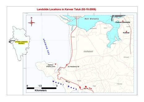
Figure-1: Important landslide locations in Karwar
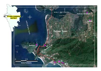
Figure 2: Google Earth image of Karwar showing landslide areas
Horticultural gardens with arecanut, coconut, banana, pepper, cardamom, cocoa, vanilla etc. characterize partially shaded narrow valleys having perennial water supply. Rice, sugarcane, groundnut, vegetables etc. are grown in wider valleys and plains of the north-east and the coast. Fields of rice, jowar, sugarcane, chillies etc and mango orchards characterize the otherwise wooded landscape of Mundgod and Haliyal. Unlike anywhere else along the South Indian coast the Western Ghats come too close to the coast in Karwar, some of its promontories entering into the sea itself. The steep escarpments of the Western Ghats form almost a semi-circle to the south, west, and far north of Karwar, closer to the Goa border. The National Highway-17 winds its way through the foothills and coastal alluvium, before entering the Karwar town, from where it passes northwards parallel to the beach. The Karwar port is situated towards the immediate south-west of the main town in the Karwar Bay. The fisheries port at Baitkol is close to the main port on the east of a 210 m high promontory of the Western Ghats. The INS Kadamba Naval Base occupies the narrow stretch of coastal strip from north of Ankola taluk to the south of the Karwar port. Many hills of heights from 300 to 500 m are present within few kilometers of Karwar town.
Locations of landslides: The 21 landslides of different magnitudes happened in the hills, most of them along the NH-17 and other roads (Figures-1 & 2 for important landslide locations). The densely populated town itself was lucky to have escaped from the damages of landslides but not from the flood fury. Some of the low hills that suffered landslides are in the villages bordering the south of the estuary in the villages of Kadwad, Makkeri and Mandralli. Habitations have sprung up along the toes of these low hills in these villages. But human casualties (19 deaths) happened only in Jariwada site (Kadwad-2). The locations of the landslides are given in the Table-1. The NH-17 was blocked in several places due to the landslides in Arga and Binaga. Some of these slides destroyed the compound wall of the Naval base to the west of the highway. The Baithkol fisheries port and main port areas together suffered 5 landslides; as all these happened just outside the densely populated hillsides the people had providential escape. Shirwad hill of 81 m, bordering the marshes had a landslide and roughly 100,000 cum material came out of it.
| Slide location | Lat –Long | No. of slides | Approx. volume of slide material |
| Kadwad-1 (near Forest naka) | 14°49’59.2”N -74°10’39.8”E | 01 | 400,000 cu.m |
| Kadwad-2 | 14°52’40.2”N -74°10’47.6”E | 01 | 750,000 cu.m |
| Arga (near NH-17) | 14°46’51.2”N - 14º46’58.9”N 74°08’29.2”E - 74°08’47.3”E | 04 | 70,000 cu.m |
| Baithkol (near port) | 14°48’07.4”N - 14°48’16.5”N 74°06’47.9”E - 74°06’50.8”E |
05 | 14°48’38.7”N - 74°10’47.6”E 88,000 cum |
| Shirwad | 14°48’38.7”N - 74°10’47.6”E | 01 | 100,000 cu.m |
| Mandralli | 14°50’50.2”N - 74°09’22.7”E | 01 | 45,000 cu.m |
| Makeri | 14°49’15.3”N - 14°50’50.2”N 74°10’17.5”E - 74°10’17.6”E |
03 | 13,300 cu.m |
| Baad | 14°48’14.5”N - 14°48’25.1”N 74°08’13.2”E - 74°08’22.4”E | 02 | 8,000 cu.m |
| Binaga | 14°46’53.9”N - 14°47’27.9”N 74°06’53.5”E - 74°08’10.0”E |
03 | 37,000 cu.m |
Jariwada (Kadwad-2) had the worst landslide in the history of Uttara Kannada district which buried alive 19 people, and destroyed several houses and property. The slide happened on a mound of 65 m, to the south of Kali estuary. The slide material volume of approximately 750,000 cu.m, traveled a distance of 300 m, burying people and destroying houses and entering the estuary, its further advance stopped by the Konkan Raliway embankment (Figures 3-5). Kadwad -1 slide happened in another mound of 78 m. About 400,000 cu.m of debris and soil travelled a distance of 300m from the slide, crossing a road there wwas no human casualty from this slide (Mishra, 2009). Interaction of a variety of factors caused the landslides. Of these important are geological factors, excessive rainfall and anthropogenic pressures.
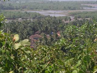
Figure 3: Kadwad village on the bank of Kali estuary
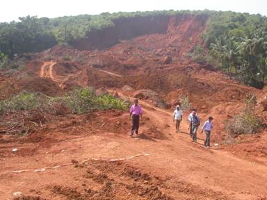
Figure 4: Kadawd – 2 (Jariwada landslide)
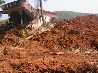
Figure 5: A house that was drifted and destroyed in the Kadwad-2 landslide
| * Address for Correspondence: | |
|
Dr. T.V. Ramachandra Energy & Wetlands Research Group, Centre for Ecological Sciences, Indian Institute of Science, Bangalore – 560 012, India. Tel : 91-80-23600985 / 22932506 / 22933099, Fax : 91-80-23601428 / 23600085 / 23600683 [CES-TVR] E-mail : cestvr@ces.iisc.ac.in, energy@ces.iisc.ac.in, Web : http://wgbis.ces.iisc.ac.in/energy |
|