 |
Landslides in coastal Uttara Kannada: Management towards risk reduction |
Energy & Wetlands Research Group, Centre for Ecological Sciences, Indian Institute of Science, Bangalore 560 012, India
E mail: cestvr@ces.iisc.ac.in, mds@ces.iisc.ac.in
Geological Factors
Landslides on lateritic hills: Coastal hills of Uttara Kannada broadly come under two categories. Hills which rise precipitously, most of them exceeding 200 m high, have granite as the main rock type. These hills characterize northern coastal stretches from Ankola to Karwar. Low lateritic, flat-topped hills and plateaus, not exceeding 100 m are feature of the southern coast of Kumta, Honavar and Bhatkal taluks. The main rock type of landslide hills in Karwar is granitic. However, some of the low hills bordering the Kali estuary are nothing but mounds of soil with laterised tops. The Kadwad hills (Kadwad-1 and 2) fall in this category. Such hills are not true hills of the Western Ghats but constituted of sedimentary soils deposited by archaic water courses that rushed down from the hills of Ghats. Forests of evergreen nature flourished once on these soil mounds, as their vestiges in a sacred grove at Kadwad-2 site indicate. Similar was the case with most other laterite topped low hills and plateaus of coastal Uttara Kannada. Shifting cultivation through ages and savannization for cattle grazing created much denudation of the coastal hills (Chandran, 1997).
An understanding of laterite formation is required to explain some of the Karwar landslides, especially of Kadwad hills. Laterites are formed by the decomposition of rock, removal of the bases and silica and formation of oxides of iron and aluminium at the top of the soil profile. They are soft when wet but harden with age. Laterites are of two types. Primary laterite is found in situ. The original rock structures, joints and quartz material are in tact and the laterite deposit overlies the bedrock. Primary laterite is found at higher altitudes. The Indian south-west coast laterites are considered to be of secondary nature, being formed from sedimentary deposits such as gravels and pebbles by sesquioxide impregnation and cementation. They are pellet type and quite different from the underlying soil or bedrock. These laterites have a continuous softening effect with depth. The laterites are normally subjected to alternate wet and dry climates (Ranjan and Rao, 1991). Leaching down of soluble materials during rains and cementation of accumulated detritus, especially iron and aluminium, on exposure makes secondary laterites dry and hard. Denuded hills and plateaus covered with hardened and eroded surface laterite, with characteristic honey-combed structure, are characteristic of southern coast of Uttara Kannada. These hills are very stable, being covered with natural shields of iron rich laterite. The two hills at Kadwad, (Kadwad-1 of 78 m & Jariwada-Kadwad-2 of 65 m) exhibit only partial laterite formation towards the exposed top. Exposed indurated boulders with typical honey comb structure, characteristic of the southern hills of Uttara Kannada coast are scanty in the Kadwad hills. Laterisation process is incomplete iniside the hill also (Figure-6) mainly due to insufficient soil drainage due to the closeness of the estuary and the hills themselves being formed on palaeo river courses as springs exist in these hills to this day. ‘Jariwada’ in local language means hamlet situated on ‘jari’ or spring. Water table is high in the Kadwad village and it is expected also for the water to rise through the soil by capillary force from below. Soil samples from the bottom of Kadwad-2 showed 88.3% sand revealing its weak foundation. Such dampness in the interior of these clayey soils with high mix of sand especially towards the base would have been considerably aggravated by the heavy rains of late September and the first two days October. Water would have percolated through the thin mantle of laterite as well as through crown cracks developed on the hills, understandably due to swelling of the clayey soil in the interior.
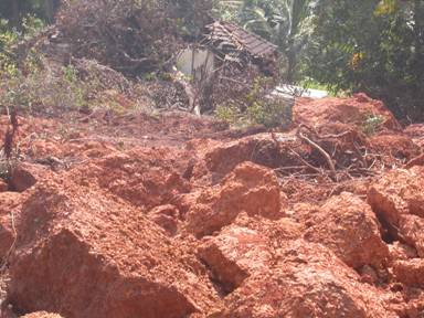
Figure 6: Incompletely formed laterite due to water logging in Kadwad-2 landslde
The natural proneness of the weak structured Kadwad hills to landslides would have been aggravated by deforestation due to past shifting cultivation, hacking for biomass by the locals, ever-increasing toe cutting by locals for expansion of holdings, soil removal by some local contractors etc. The situation got worsened when the remaining natural vegetation was cleared some years ago by the Cashew Corporation for raising plantations, unaware of the fact that cashew would be a poor choice for covering fragile, landslide prone hills of soft clayey, water-logged soils. The stumps of the earlier trees, expectedly, underwent deterioration making hollows on hill surface facilitating increased rain water seepage into the interior of the hills and soil expansion probably causing the formation of crown cracks. The heavy rains ultimately triggered the disastrous slope failures during early October 2, 2009. Indeed, any coastal hills, with their bases moored in estuarine shores, if they are inadequately covered with natural vegetation and/or their sides cut for expansion of holdings or for soil, landslides are likely to happen. Such a slide occurred in the Holegadde village of Kumta taluk during the rainy season of 2010, but fortunately without any casualties.
Landslides on granitic hills: Granite is the main rock type in the slides that happened in 12 locations. Eight of these slides were along the hills adjoining the NH-17, viz. Arga (4 slides), Binaga (3 slides) and one opposite the Karwar commercial port. The entire western portion of these villages fall under the high security INS Kadamba Naval Base, the NH side wall of which was badly breached by landslides and storm waters, for which the wall acted like a dam that could not stand the force of the storm water. The debris in all these slides included granite boulders, cobbles and overburden of soil and weathered granite (figure-8). Five slides happened in the hills towards the south and south-west of Karwar Port at Baithkol. In a slide that took place along the vertical slope of the hill (DC’s residence hill) huge granite boulders came crashing down on the NH-17 and even crossed over it towards the Arabian Sea. Approximately 10,000 cu.m of debris moved down the slope and blocked the road. In the rest of the Baithkol slides, close to the fisheries port, the material consisted of boulders, cobbles of weathered granite and mafic dyke, laterite and lateritic soil (Mishra, 2009).
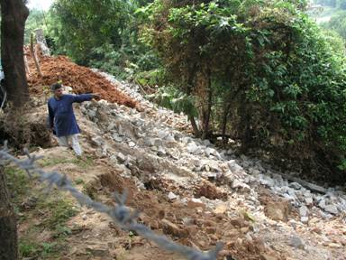
Figure 8: Landslide along NH-17, the slide material entering INS Kadamba Naval Base breaking through the compound wall
Shearing forces: On steep granitic slopes, inadequately covered with vegetation, heavy rains would have soaked up the overburden of soil and fractured rocks activating shearing forces. Cutting deep swathes in the hills for expansion of holdings, highways and other roads as well as for soil removal would have also activated shear forces. In the words of Dikshit (2009): “The underlying rock is almost everywhere granite which is non-porous to water. Though the hills look monolithic …. There were many deep cracks in the granite rocks that were draining rainwater that fell on the hill surfaces. Over this granite hill is the soil …. Of varying thickness bound and staying in place primarily due to cohesive and adhesive biding forces. It is plastic but rock like hard in dry summers, but becomes a viscid mass capable of moving under sufficient shearing force in the form of a semi-solid mass having great momentum along slopes. At many landslide affected places the original forests were degraded and replaced by shrubs. Owing to high rainfall, low porosity of the granites, and moderate jointing percolated water flow laterally as subsurface flow. Since laterite is missing at many places, there is no continuity between rocks and soil, and hence water lubricates the contact between rocks and soil/weathered debris thereby increasing shearing forces (Hegde, 2009).
TRIGGERING FACTORS
Rainfall: Slope instability due to rainfall is a common geotechnical problem in tropical and subtropical areas. Infiltration of rain water into a slope decreases slope stability. When water starts to infiltrate the unsaturated soil the negative pore-water pressure builds up turning into the mechanism that causes slope failures (Gasmo et al; 2000; Tsaparas et al., 2001). Slope failures in the tropical regions like Malaysia are commonly triggered by frequent rainfall (Lee et al., 2009). Deforestation on steep slopes by logging or fires have increased debris-flow frequency (DeGraff, 1991; Guthrie, 2002). Analysis by Dahal and Hasegawa (2008) of 193 landslides in the Himalayan locations showed that when the daily precipitation exceeded 144 mm, the risk of landslides was high. All the 21 landslides in Karwar occurred on 2nd October, 2009, the most fatal of them at Jariwada in Kadwad, between 4-4.30 pm. By the morning of October 2, Karwar had already received 3,370 mm of rainfall for the season. That fateful day, when all the slides are stated to have happened, Karwar experienced a very heavy spell of rains exceeding 400 mm (423.06 mm recorded in the morning of October, 3rd).
Recurrence of heavy rainfall: As the hill slopes of coastal Karwar remain heavily deforested slope failures could happen on any day of incessant rains, the threshold for this important triggering factor will depend on the previous rainfall during the season, the state of tree cover in the hills and the degree of slope. A look at the daily rainfall history of Karwar for the 1994-2009 period (Figure-7) shows that heavy rainfall (> 200 mm a day) events happen periodically. If the site-specific threshold value is crossed the landslides could happen on any day in vulnerable slopes. October 2, 2009 episodes of 21 landslides indicate that on the recurrence of similar events slope failures are likely to return.
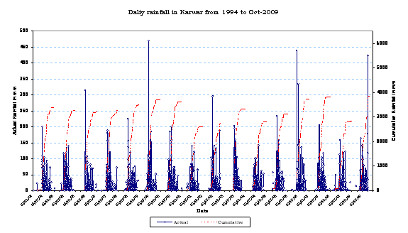
Figure 7: Sixteen years (1994-2009) of daily rainfall records for Karwar showing frequent recurrence of heavy rainfall events (>20 cm a day)
Deforestation and landslides: The heavy annual rainfall of over 3,000 mm at Karwar is sufficient to create an evergreen forest of high biomass. Given moderate amount of human pressures happening today as in many of slightly more interior parts of Karwar taluk, in rest of the forests, even on more precipitous slopes, hardly had any landslides taken place in the past. These inner coastal forests normally have denser tree growth and basal area of 30-40 sq.m/ha. Same is the situation in most of Uttara Kannada which has hardly any history of fatal landslides. It is well known fact that good forest cover on hills is some kind of security from landslides and flash floods. Abe and Ziemer (1990) state that forest vegetation, especially tree roots can extend into joints and fractures in the bedrock or into a weathered transitional layer between the soil and bedrock. The stabilization of slopes by vegetation depends on the depth to which the roots grow. The more the roots penetrate a potential shear plane, the greater is the chance that the vegetation will increase slope stability. Rooting strength is important factor in cohesion of substratum. Forest vegetation can potentially attenuate downstream effects of landslides. If the slope vegetation is clear-felled the probability of landslides occurring will increase, particularly after a few years when the roots are decomposed and loose their stabilizing force. According to Bruijnzeel (2004), whereas a well developed tree cover can prevent shallow landslides up to about 1 m depth, deep landslides of >3 m are not appreciably affected by forest cover. In cases of extreme climate events such as hurricanes, trees may actually increase slope instability due to the tree weight and the susceptibility of particularly high trees to uprooting due to extreme storms, damaging the soil matrix. Thousands of landslides occur in the Himalayas every year. On an average, nearly 200 earthquakes of smaller magnitude, most of them undetected by local communities, occur every year in the Uttarakhand region alone. According to V.C. Thakur, former Director of Wadia Institute of Himalayan Geology, the uncontrolled downhill flow of water after heavy rains, particularly along barren slopes, was an important causative factor in these landslides. A study conducted in 1984 on the relationship between the building of the Mussoorie-Tehri road and landslides revealed that landslides caused more devastation in deforested rather than forested areas (Kazmi, 1998).
Too poor and human impacted vegetation: We selected three localities for vegetational study in the coastal hills of Karwar, two of them in the landslide affected hills (Kadwad and Arga) and the third one in Amdalli, on a steep rising coastal granitic hill, of over 300 m abutting on the NH-17, which has somewhat lesser human pressure, and where landslides have not happened, despite having experienced almost similar rainfall conditions as the rest of coastal Karwar. All the hills had, presumably, a history of shifting cultivation during the pre and early colonial period, at least towards the latter half of the 19th century, as per ecological history of the region and as revealed by nature of the present day vegetation and eroded soil surfaces. Some of the elderly residents of Kadwad-2 site also referred to the hill as bearing the name kumri-jaga (shifting cultivation locality), and Kunbis (former shifting cultivators) once resided in the village. The passage of over one century after last of shifting cultivation episodes would have facilitated forest succession leading towards reasonably good semi-evergreen forests in all the hills. However, due to increased pressure from growing population, for meeting their biomass needs the British declared the forests of most coastal hills as ‘minor forests’ which eventually suffered from over-exploitation of resources. Remains of a sacred grove towards the base of the hill has few large forest trees such as Mammea suriga, Mimusops elengi, Mangifera indica and Sterculia guttata. The vegetation analysis of the three sample sites is given in the Table 2.
Table 2: Vegetation composition
| Study locality | Estimated trees/ha | Estimated basal area/ha (sq.m) | % evergreen trees | Mean ht (m) |
| Kadwad-2 | 76 | 2.356 | 3 | 3.8 |
| Arga hill | 44 | 5.92 | 20 | 5.9 |
| Amdalli hill | 435 | 26.84 | 87 | 10 |
Some decades ago the Kadwad hills (the sites of two major landslides) were stripped of natural vegetation; in Kadwad-2, 20 hectares were planted with cashew. Uncared for subsequently the hill has neither good cashew trees nor any other native species. The trees were sparse and stunted with a density of just 76/ha; it could have been at least 350/ha, more of evergreen nature, and the basal area maintained at a minimum of 30 sq.m/ha, considering the fragile geology. The present basal area of 3.8 sq.m/ha, is too low to offer any slope stability. The cashew is a shallow rooted tree to offer any slope stability. The Arga hill was having dense growth of weeds and scrub and trees were sparse and the basal area too low at 5.9 sq.m/ha. Amdalli hill, which did not undergo any landslide, and considered a control, had much higher tree number at 435/ha. The basal area of 26.84 sq.m/ha is still short of the desired 30 sq.m/ha. Moreover the trees were mostly undersized in height and girth as they were subjected to constant hacking. Most of the species were of secondary nature; yet basically multi-strata evergreen vegetation, ideal for soil and slope persisted. Most of the landslide hills had impenetrable tangle of weeds and creepers and thorny bushes, all shallow rooted. The entire coastal hillscape of coastal Karwar is fragile and calls for urgent attention as to the restoration of ideal ecological conditions leading to greater stability in the region.
Alterations in slope angle: According to Mishra (2009) the original slope angle of Jariwada hill of Kadwad was very low at ~20º, prior to human interference. The modification of the slope by cutting 15-20 m vertical slope (as observed in the right and left flanks of the slide zone of 60 m width and 30 m depth) for human settlement and plantation increased instability. In Kadwad-1, which had a 100 m width slide, of 15-20m depth, there was a vertical cut of 10 m height near the toe. The slope was cut for road formation. There was also excavation at the mid-slope to flatten the slope. The toe cutting and removal of material from the site has increased the driving force. As the slope forming material is mostly lateritic soil, clayey soil and overburden, the over-saturation of the slope material decreased the resisting force. Similar toe cutting, mostly for road making, happened almost in all the studied landslide locations. The original slope angles were gentle with a very low relief.
Land use changes: The clearances of natural vegetation for planting cashew apparently became an important cause for landslide in the Kadwad hills, so too expansion of household gardens into the hill by slope cutting. Slope cutting for road formation was common cause wherever landslides happened. There has been heavy colonization of humans in the Baithkol fisheries port area, causing rampant toe cutting of the isolated, steep sided 210 m tall hill protruding into the Arabian Sea from the south of the Karwar Bay.
Improper drainage: Natural drainage of rainwater has been affected in the slide areas due to different reasons. In the Kadwad hills the water table is high due to the nearness of the estuary and the hills being ancient mounds of soil in the way of a palaeo-river course descending from the Western Ghats. Over-saturation of soils during heavy rains is a constant factor here.
Blockage of natural drainage, increasing the overburden saturation during heavy rains has been considered a potent reason for the landslides in Arga and Binaga hills. The high rising compound wall of INS Kadamba Naval Base acted like a dam impeding storm water drainage; the wall itself crumbled in few places due to the rush of storm water and slide material of stones and soil.
Stone quarrying and soil removal: In Zariwada there was reported excavation of soil in front of the slope that failed for the construction of the Konkan Railway embankment, increasing vertical slope height, inducing slope instability due to the volume and weight of material above the toe (Mishra, 2009). Granite quarries in the hills adjoining NH-17 would have also destabilized the hill sides as rocks came tumbling down from near a quarry site towards the highway and damaging the wall of the naval base.
LANDSLIDE SUSCEPTIBLE LOCATIONS PREDICTION THROUGH OPENMODELLER
This study use pattern recognition techniques such as Genetic Algorithm for Rule-set Prediction and Support Vector Machine based models to predict the probable distribution of landslide occurrence points based on several environmental layers along with the known points of occurrence of landslides. The model utilises precipitation and six site factors including aspect, DEM, flow accumulation, flow direction, slope, land cover, compound topographic index and historical landslide occurrence points. Both precipitation in the wettest month and precipitation in the wettest quarter of the year were considered separately to analyse the effect of rainfall on hill slope failure for generating scenarios to predict landslides (Ramachandra et al., 2010).
A free and open source software – openModeller was used for predicting the probable landslide areas. openModeller (http://openmodeller. sourceforge.net/) is a flexible, user friendly, cross-platform environment where the entire process of conducting a fundamental niche modeling experiment can be carried out. It includes facilities for reading landslide occurrence and environmental data, selection of environmental layers on which the model should be based, creating a fundamental niche model and projecting the model into an environmental scenario using a number of algorithms as shown in Fig. 9.
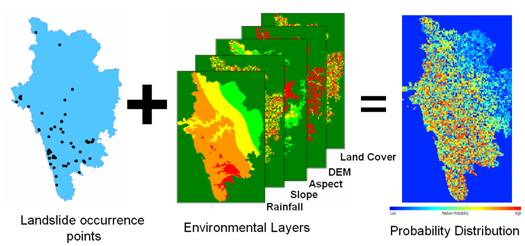
Fig. 9. Methodology used for landslide prediction in openModeller.
Two different precipitation layers were used to predict landslides – precipitation of wettest month and precipitation in the wettest quarter of the year along with the seven other layers. Figure 10 (a) and (b) are the landslide probability maps using GARP and SVM on precipitation of wettest month. The landslide occurrence points were overlaid on the probability maps to validate the prediction as shown in Fig. 11. The GARP map had an accuracy of 92% and SVM map was 96% accurate with respect to the ground and Kappa values 0.8733 and 0.9083 respectively. The corresponding ROC curves are shown in Fig. 12 (a) and (b). Total area under curve (AUC) for Fig. 12 (a) is 0.87 and for Fig. 12 (b) is 0.93. Figure 12 (c) and (d) are the landslide probability maps using GARP and SVM on precipitation of wettest quarter with accuracy of 91% and 94% and Kappa values of 0.9014 and 0.9387 respectively.

Fig. 10. Probability distribution of the landslide prone areas.
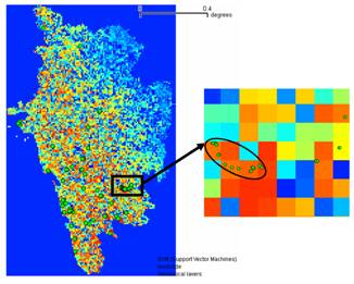
Fig. 11. Validation of the probability distribution of the landslide prone areas by overlaying landslide occurrence points.
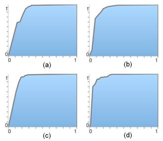
Fig. 12. ROC curves for landslide prone maps (a) GARP (b) SVM on precipitation of wettest month; (c) GARP and (d) SVM on precipitation of wettest quarter.
ROC curves in Figure 12 (c) and (d) show AUC as 0.90 and 0.94. Various measures of accuracy were used to assess the outputs. Table 3 presents the confusion matrix structure indicating true positives, false positives, false negatives and true negatives.
| True Presence | True Absence | |
| Predicted Presence | a | B |
| Predicted Absence | C | D |
Confusion matrices were generated for each of the 4 outputs (Table 4) and different measures of accuracy such as prevalence, global diagnostic power, correct classification rate, sensitivity, specificity, omission and commission error were computed as listed in Table 5. The results indicate that the output obtained from SVM using precipitation of the wettest month was best among the 4 scenarios. It maybe noted that the outputs from GARP for both the wettest precipitation month and quarter are close to the SVM in term of accuracy. One reason is that, most of the areas have been predicted as probable landslide prone zones (indicated in red in Fig. 10 (a) and (c)) and the terrain is highly undulating with steep slopes that are frequently exposed to landslides induced by rainfall. Obviously, the maximum number of landslide points occurring in the undulating terrain, collected from the ground will fall in those areas indicating that they are more susceptible to landslides compared to north-eastern part of the district which has relatively flat terrain.
| Uttara Kannada | True Presence | TRUE ABSENCE | NUMBER OF USABLE PRESENCE | NUMBER OF USABLE ABSENCE | |
| GARP with precipitation of wettest month | Predicted Presence | 120 | 0 | 125 | 0 |
| Predicted Absence | 5 | 0 | |||
| SVM with precipitation of wettest month | Predicted Presence | 118 | 0 | 125 | 0 |
| Predicted Presence | 7 | 0 | |||
| GARP with precipitation of wettest Quarter | Predicted Presence | 118 | 0 | 125 | 0 |
| Predicted Presence | 7 | 0 | |||
| SVM with precipitation of wettest Quarter | Predicted Presence | 117 | 0 | 125 | 0 |
| Predicted Presence | 8 | 0 | |||
| Uttara Kannada | Prevalence (A+C)/N | Global diagnostic Power(B+D)/N | Correct Classification Rate(A+D)/N | Sensitivity A/(A+C) | Specificity D/(B+D) | Omission Error C/(A+C) | Commision Error B/(B+D) |
| GARP with precipitation of wettest month | - | - | 0.96 | 0.96 | - | 0.04 | - |
| SVM with precipitation of wettest month | - | - | 0.94 | 0.94 | - | 0.06 | - |
| GARP with precipitation of wettest Quarter | - | - | 0.94 | 0.94 | - | 0.06 | - |
| SVM with precipitation of wettest Quarter | - | - | 0.94 | 0.94 | - | 0.06 | - |
Another case study of Kerala state, India was carried out with the same environmental layers along with 10 landslide occurrence points as shown in Fig. 13. The predicted output for precipitation in the wettest month is shown in Fig. 14 and precipitation in the wettest quarter is shown in Fig. 15 with an overall accuracy of 60%. The Kappa values for two cases were 0.966335 and 0.96532. The ROC curves are shown in Fig. 16 (a) and (b) with 0.97.
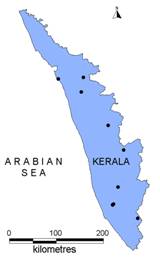
Fig. 13. Landslide occurrence points in Kerala.
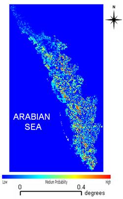
Fig.14. Probability distribution of the landslide prone areas in Kerala using precipitation in the wettest month data.
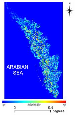
Fig. 15. Probability distribution of the landslide prone areas in Kerala using precipitation in the wettest quarter data.
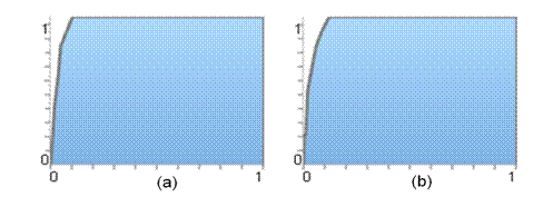
Fig.16. ROC curves for the predicted landslide prone maps of Kerala.
(a) using precipitation of the wettest month, (b) using precipitation of the wettest quarter.
| * Address for Correspondence: | |
|
Dr. T.V. Ramachandra Energy & Wetlands Research Group, Centre for Ecological Sciences, Indian Institute of Science, Bangalore – 560 012, India. Tel : 91-80-23600985 / 22932506 / 22933099, Fax : 91-80-23601428 / 23600085 / 23600683 [CES-TVR] E-mail : cestvr@ces.iisc.ac.in, energy@ces.iisc.ac.in, Web : http://wgbis.ces.iisc.ac.in/energy |
|