| Previous Session | Paper 1 | Paper 2 | Paper 3 | Paper 4 | Paper 5 | Next Session |
SESSION-6: Groundwater and Hydrogeology
PAPER-1: Groundwater Recharge in an Urban Area:
A Case Study from Bangalore Urban and Rural Districts(Karnataka State, India)
Nataraju C 1 ., Shivakumar J. Nyamathi 2 and Ranganna G 3
CONTENTS-
Abstract
Introduction
Study Area
Methodology
Results and Conclusions
Bibliography
| Abstract | up | previous | next | last |
Groundwater is an important resource of the country, which is contributing substantially for the Indian economy. Nearly 80% of drinking and domestic water needs are met through groundwater. With more than 17 million energized wells nationwide, groundwater now meets more than 15% of the country's irrigation demand. The rapid development of groundwater utilisation has also brought in new problems, viz. over exploitation associated with quality deterioration, seasonal fluctuation of water table affecting shallow wells and also pollution problems.
Quantification of natural groundwater recharge is a basic pre-requisite for efficient groundwater resource management and is particularly vital in arid and semi-arid regions. In the present study, groundwater recharge is estimated for 59 rain gauge stations of Bangalore district using water-table fluctuation method for both monsoon and non-monsoon seasons. The district receives 61mm average recharge, with a minimum of 49mm for Dodballapur taluk and a maximum of 75mm for Hoskote taluk.
| Introduction | up | previous | next | last |
Water is the vital element of life and a truthful companion of humanity. It is the most abundant element on earth, covering about 1400 million cubic kilometers of which only 0.003percent is actually usable, the rest forming part of oceans and polar ice caps. Urban, domestic and industrial consumers are using larger amount of water and consequently depleting the available resources. The goal should be to promote water use and management in such a way that society's needs are met while at the same time water resources are protected. Non-availability of adequate drinking water due to progressively depleting surface and groundwater is a big challenge to the water management system.
Even today more than 90% of our rural population is primarily dependent on groundwater. Water supplies from groundwater sources are becoming increasingly important, but they are threatened by unplanned exploitation and contamination from many sources. Protection and conservation of groundwater is, therefore, a top priority task, particularly in regions of limited available water resources.
Groundwater recharge in general sense is the downward flow of water reaching the water table, forming an addition to the groundwater reservoir. Recharge of groundwater may occur naturally from precipitation, rivers, canals and lakes and as man induced phenomenon via such activities as irrigation and urbanisation.
Urbanisation has profound impacts on the hydrological cycle; effecting changes in groundwater recharge mechanisms. The provision of water supply sanitation and drainage are the key elements of the urbanisation process. A common factor to most urbanisation is that it results in-
(i). Impermeabilisation of a significant proportion of the land surface, and
(ii). Major water imports from outside the urban limits.
Urbanisation also causes major changes in the frequency and volume of recharge, although these changes cannot be measured directly and are thus difficult to quantify. The changes in recharge caused by urbanisation in turn influence the groundwater levels and flow regime in underlying aquifers.
This situation prompted the authors to undertake a field-cum-office study of Bangalore district. Consisting of eleven (11) taluks covering an area of 8076 sq.km. for estimation of groundwater recharge by water table fluctuation method formulated by Central Groundwater Board (CGWB) in 1997.
| Study Area | up | previous | next | last |
The district of Bangalore forms part of south interior Karnataka. There are no perennial rivers flowing and hence the availability of surface water for irrigation, domestic and industrial purpose is limited. Therefore groundwater is being extensively used for drinking industrial and irrigation purposes. Over the years the use of groundwater has increased manifold and in some taluks groundwater is being overexploited.
Bangalore is one of the progressive districts out of 27 districts in Karnataka. Bangalore district is divided into Bangalore Urban District (3 taluks) and Bangalore Rural district (8 taluks). The district is located between north latitude 12 o 15' and 13 o 31' and east longitude 77 o 04' and 77 o 59'. The district has a typical monsoon climate, receiving an average annual rainfall of 790mm. Excessive demand for water in the district has put lot of strain on groundwater resources. As a result groundwater levels are declining from year to year and it is being overexploited.
Physiography and Drainage
Bangalore district forms a gently sloping rolling topography with gentle slope from north to South. The western portion of the district is covered by a chain of small-disconnected hillocks. Northern, eastern and central parts of the district are almost plane with undulating topography.
Major portion of the district is drained by River Arkavathi River Kanva and River Shimsha which are tributaries to the River Cauvery. The Northern portion of the district is drained by North Pinakini (Pennar) and eastern part is drained by South Pinakini (Ponniyar). A small portion of northeastern portion is drained by Polar.
Climate
Bangalore district enjoys a pleasant climate. The maximum temperature is about 38 o C in summer and minimum temperature is about 15 o C during winter. It is neither too humid nor too dry. The relative humidity is generally 86% during monsoon and 63% during dry months. Number of rainy days is 60 in a year.
Soils
The soils of Bangalore district are broadly classified into: (i) Red loamy soil, (ii) Red sandy soil (iii) Laterite soil and (iv) Laterite gravelly soil.
Geology
Geology of Bangalore district is broadly described under two groups:
(i). dominating Archean crystalline formation comprising peninsular gneiss's complex with small patch of hornblende schist in the northern part and intrusive closepet granites all along the western part of the district , and
(ii). small stretch of about 25km (in two patches) comprising unconsolidated sediments (Channapatna and Devanahalli ).
| Methodology | up | previous | next | last |
The groundwater recharge was estimated using watertable fluctuation method, which was recommended by the Groundwater Estimation Committee (1982). Recently, CGWB has published the guidelines and norms for assessing the quantum of groundwater (1997).
The method is based on the water level fluctuations of the observation wells, network set up for the purpose where water levels are measured regularly, i.e., every month. Table 1 presents water level fluctuations during pre-monsoon, monsoon and post-monsoon seasons for the entire district (18 years average). The fluctuations obtained from these wells are used along with specific yield, average annual rainfall, average monsoon rainfall and average non- monsoon rainfall to determine the groundwater recharge for both monsoon and non-monsoon seasons.
Procedure followed for calculating groundwater recharge for Anekal observation well is furnished below:
(1) R.G. Station : Anekal
Observation well : Anekal
Taluk : Anekal
1. Monsoon Recharge
a) Total Geographical area = 11515 ha
b) Aquifer area = 11515-2303=9212 ha
c) No. of observation wells = 1
d) Years of observation wells data = 15yr
e) Average depth to water table (trough) = 13.61 m
f) Average depth to water table (peak) = 12.91 m
g) Difference in water table fluctuation = 0.70 m
h) Average annual rainfall = 851.54 mm
i) Average Monsoon rainfall = 782.14 mm
j) Average non-monsoon rainfall = 69.4 mm
k) No. years of observation of rainfall = 17 yr
l) Long term average normal monsoon rainfall = 749.5
m) Grass khariff draft = 277.55 ha-m
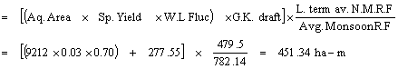
Normalized Monsoon Recharge
II Rainfall Infiltration Index (RI)
a) Normalised monsoon recharge (NMR) = 451.34 ha-m
b) Depth of infiltration during monsoon (DIM) = 48.9 mm
![]()
c) Monsoon rainfall Index (MRI) (%) = 6.26%
![]()
d) Depth of infiltration during non-monsoon (DINM) = 4.34 mm
![]()
III Non-monsoon Recharge (NMR)
a) Depth of infiltration = 4.34 mm
![]()
Recharge from surface made irrigation = 123.52 ha-m
Recharge from Tanks = 153.3 ha-m
Monsoon = 89.42 ha-m
Non-Monsoon = 63.88 ha-m
![]()
![]()
Total recharge = 46.96 + 19.59 = 66.55 mm
The groundwater recharge for both monsoon and non-monsoon seasons for the entire district is presented in Table-2a & b.
Table-2a: Recharge from rainfall Bangalore Urban District
Sl No. |
R. G. Stations |
Area Covered (ha) |
Avg. Annual Rainfall (mm) |
Monsoon Recharge (mm) |
Non-monsoon Recharge (mm) |
Total Recharge (mm) |
Taluk Average (mm) |
1 |
Anekal Taluk Anekal Attibele Bangalore Airport Jigani Sarjapura Varthuru |
11515 8490 8781 18387 10646 7900 |
851 746 791 573 797 423 |
46.96 41.15 71.26 40.48 51.68 63.98 |
19.59 20.32 21.20 21.50 20.46 22.63 |
66.55 61.47 92.46 61.98 72.14 86.61 |
73.53 |
2. |
Bangalore North Taluk Bangalore Airport Bangalore Rly. Stn. Bangalore (Observ) Chikkajala GKVK Campus Gondahally Post Hebbal Hesaraghatta Kengeri Nelamangala Soladevanahally Tavarekere Yelahanka |
875
2425 13350
10250 5550 6050 2050 6250 11025 5700 6250 |
826
944 761
711 769 665 846 690 570 967 690 |
12.22
13.55 60.95
44.72 45.90 55.52 48.65 43.08 36.88 49.42 53.44 |
1.14
1.20 22.66
15.30 19.15 23.36 17.53 9.60 12.98 22.06 11.06 |
13.36
14.75 83.60
60.02 65.05 78.88 66.18 52.68 49.86 71.48 64.50 |
54.81 |
3 |
Bangalore South Taluk
Bairamangala Bidadi Bangalore Airport Bangalore (Observ) Hebbal Hosakote Jigani Kengeri Krishnarajapura Manchanabele Tavarekere Thippagondanahally Varthuru Yelahanka |
5350 2850 10387 2825 1075
6025 18362 11562 4025 7087 4225 6612 1450 |
850 799 826 944 769
593 846 440 805 967 670 443 690 |
48.72 50.43 25.25 12.95 51.33
54.20 45.00 43.81 55.23 60.98 49.47 40.21 44.92 |
26.87 24.59 8.26 1.15 11.13
10.35 20.00 7.44 21.52 24.83 17.11 9.50 11.64 |
75.59 75.02 33.51 14.10 62.46
64.55 65.00 51.25 76.75 85.81 66.58 49.71 56.56 |
61.13 |
Table-2b: Recharge from rainfall Bangalore Rural District
Sl No. |
R. G. Stations |
Area Covered (ha) |
Avg. Annual Rainfall (mm) |
Monsoon Recharge (mm) |
Non-monsoon Recharge (mm) |
Total Recharge (mm) |
Taluk Average (mm) |
1 |
Channapatna Taluk Channapatna
Kanva |
38567 16332 |
891 882 |
47.00 51.01 |
16.00 17.83 |
63.00 68.84 |
65.92 |
2 |
Devanahally Taluk Devanahally
Vijayapura |
31519 11181 |
821 578 |
41.83 60.14 |
14.89 7.68 |
56.72 67.82 |
62.27 |
3 |
Doddaballapur Taluk
Doddapallapur Doddabelavangala Melekote Sasalu Tubugere |
16864 22912 12500 20540 11757 |
745 663 688 434 807 |
13.00 65.30 41.67 04.25 69.01 |
06.00 10.70 05.81 01.45 28.49 |
19.00 76.00 47.48 05.70 97.50 |
49.13 |
4 |
Hosakote Taluk
Anugondanahalli Hosakote Hindiganal Sulebele |
13132 18709 13641 10342 |
744 812 820 627 |
67.00 58.42 51.68 62.27 |
10.00 23.73 16.62 10.40 |
77.00 82.15 68.30 72.67 |
75.03 |
5 |
Kanakapura
Doddamaralavadi Harohalli Kanakap[ura Mullahalli |
23746 21124 41795 68082 |
787 726 785 473 |
30.09 35.17 45.34 57.28 |
12.70 10.57 10.24 05.39 |
42.79 45.74 55.58 62.67 |
51.69 |
6 |
Magadi taluk
Kudur Magadi Soluru |
22599 37688 17259 |
980 949 832 |
44.66 36.14 39.03 |
19.92 11.70 18.50 |
64.58 47.84 57.53 |
56.65 |
7 |
Nelamangala Taluk
Dabaspet Nelamangala Thyamagondle |
13103 14524 19478 |
930 680 831 |
54.00 54.68 41.80 |
18.03 09.67 12.23 |
72.03 64.35 54.03 |
63.47 |
8 |
Ramangaram Taluk
Bairamangala Bidadi Ramangaram | 8821 16915 34190 |
856 832 922 |
41.52 42.70 44.00 |
09.98 19.18 11.52 |
51.50 61.88 55.52 |
56.30 |
Note: Computations are based on 18 years (1980 97 ) of rainfall data.
| Results and Conlusions | up | previous | next | last |
Lack of adequate potable and agricultural water supplies inhibit the progress of developing countries and are the cause of considerable hardship to humans' world wide. Potable water shortages occur as surface water sources and shallow wells desiccate during the dry season or become contaminated and unfit for consumption. Groundwater flow has two primary components; a dominant vertical flow, which recharges fractures at depth, and a more subdued sub-horizontal flow. Water-bearing fractures generally lie along valley bottoms, where weathering is the deepest and enhances groundwater recharge.
The accuracy of any method for assessing groundwater recharge depends on-
• determination of appropriate distribution of aquifer parameters;
• the data available on land use /land cover spatial and temporal distribution;
• the extent to which recharge values of seepage from irrigated land together with rainfall augment the recharge; and
• the level of hydrogeological details of the system under investigation.
For the entire Bangalore district under study, Dodballapur taluk has minimum average recharge value of 49.13 mm, whereas Hoskote taluk has maximum recharge values of 75.3mm. Due to urbanisation, Bangalore north and south taluks have recharge values of 54.81mm and 61.13mm respectively. The water table fluctuation method takes into consideration all parameters relevant to the water balance study. However, the method is tedious and time consuming for data collection and synthesis. The only solution is to go in for remote sensing and geographic information system techniques. According to Shih (1989), for a certain RS and GIS project the cost involved in the conventional method was about $44/ sq. km, while that of the remote sensing (Landsat) approach was about $4/sq.km.
| Bibliography | up | previous | next | last |
Athavale, R.N., Rangarajan, R., and D.Muralidharan (1992) : Measurement of natural recharge in India. Inl. Geophysical Society of India. Vol. 39, pp. 235 - 244.
Hendry, M. J (1983): Groundwater recharge through a heavy-textured soil. Jnl. Hydrology, 63, pp 201-209.
Nyamathi, S.J., Puttaswamy, Nataraju, C., and G. Ranganna (1999): Studies on groundwater recharge potential of north and south taluks of Bangalore, Bangalore Urban Districts, Karnataka, National conference on Water Resources and Mangement, S.V. University, Triupathi.
Rajagopalan, S.P., Sharma, S.K., and N.R. Thankivale (1998) : Rainfall recharge by water-table fluctuation method, Detailed Guidelines for implementing the Groundwater Estimation Methodology-1997. CGWB, Ministry of Water Resources GOI, April, pp 118 145.
Shih, S.F (1989) : Satellite data and geographic information system for land use classification. Jnl. Irr. & Drge. ASCE., Vol. 114, No.3, August, pp.505 519.
| Address: | up | previous |
1 Department of Civil Engineering, S.J. College of Engineering, Mysore. Karnataka. India
2 Department of Civil Engineering, Bangalore University, Jnanabharathi Campus, Bangalore. Karnataka. India
3 UGC-DSA Centre, Department of Mathematics, Bangalore University, Central College Campus, Bangalore 01. Karnataka. India
Phone: 2220483
E-mail: granganna@yahoo.com