| Previous Session | Paper1 | Paper 2 | Paper3 | Paper 4| Paper 5 | Paper 6 | Next Session |
SESSION-2: Watershed Hydrology / Pollution
PAPER-3: Lakes, Open Spaces and Built Form Studies in
Bangalore Metropolitan Area
Rajan Sridhar, Rama P.S., Mamatha P. Raj, Pushpa D., Vaseem A.S. and Chandrashekar M.N.
CONTENTS-
Abstact
Factors influencing Lakes
Microclimate
Case Studies
Inference and Remedial Measures
Bibliography
| Abstract | up | previous | next | last |
The paper attempts to investigate lakes/ keres/tanks, in the Bangalore Metropolitan Area, as they are an important component of a much neglected urban landuse i.e. Open Spaces. Extensive studies have already been made on lake systems, their conservation, restoration and management. This study has been made on the relationship of lakes to urban open spaces and built form. Lake surrounds have been studied and analysed for compatibility of land uses. Planning regulations have been examined along with financial feasibility.
The methodology consists of visual studies and observations of phenomena related to water bodies and lake systems in urban areas. The following prominent lakes were identified for study: Bellandur, Varthur, Agara Kere, Ulsoor, Lalbagh, Yediyur, Kempambudhi, Sankey, Mattikere and Hebbal Lake.
The lakes are classified into two categories as Urban and Suburban Lakes, based on their location. Of the urban lakes, Ulsoor, Sankey and Yediyur are the most used by the public. An extensive visual survey of the identified lakes was undertaken with reference to maps available. Over 700 digital photographs were exposed as a part of the study. Inferences and remedial measures were suggested based on the analysis of the above study, which looks at lakes as an essential part of the urban eco-system and prescribes their conservation, restoration and management strategies to ensure a healthy urban fabric.
| Factors Influencing Lakes | up | previous | next | last |
Topography:
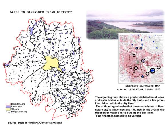
The topography of Bangalore comprises of numerous ridges and valleys (Map 1). Lakes are found at different elevations, which efficiently store rainwater and recharge the ground water as well. These lakes are often connected in a chain. Ponds and marshy wetlands are also connected to this chain. Water bodies nourish the flora and fauna, which in turn retain moisture and ensure a high level of ground water table and a cool climate.
Climate:
Over the years, with the increase of population, built form, the encroaching of open spaces and breaching of lakes has reduced the area of Open Spaces' in the land use pattern. This has resulted in an increase in temperature in an urban concrete jungle such as Bangalore. Built form tends to elevate temperature as the materials used are of an absorptive nature.
Open Spaces:
The urban open spaces having green cover assist in reducing temperature by throwing shade and shadow. Also due to solar radiation, photosynthesis and transpiration phenomena, moisture is retained and cooling takes place.
Urban Sinks:
Lakes as a part of the system of open spaces function as urban sinks to absorb heat and pollution from the air. Water, having a higher specific heat than land is normally warmer in winter and cooler in summer and usually cooler during the day and warmer at night, than the terrain.
Rainwater and Groundwater:
Bangalore is poorly placed on ridges and valleys with respect to ground water. Rainwater is the main source of replenishment of ground water. The valley gradients being steep, the rainwater flows out very fast, within a few hours. The soil receives rain, which is stored as ground water. It often flows away in various directions on the rock strata that are impervious.
Rain water Harvesting :
The quantum of rainfall on the vast area of the city, if harnessed properly, is enough to sustain the needs of the population and other water requirements of Bangalore. But sewage and sullage in the storm water drains pollute the runoff that collects in these lakes. Industrial effluent discharges are a major source of lake water pollution. The still surviving lakes of Bangalore and suburbs have a potential of recharging the groundwater, in spite of the continuous withdrawal of ground water (Venkataraman R, 2000 ).
Lake restoration:
There have been many calls for saving rest of the lakes from breaching and extinction. Prevention of pollution and restoration to clean condition of all existing lakes in Bangalore have been voiced and tried on many occasions.
| Microclimate | up | previous | next | last |
The microclimate of Bangalore is the net result of several interacting variables including temperature, water vapour, wind, solar radiation, and precipitation. Like topography, vegetation and water, microclimate is a major component of the environment.
Terrain and Microclimate :
Topography is a major determinant of microclimate along with the lakes and vegetation of Bangalore. At night, cold air falls down to the lowest points of the valleys whereas in the daytime conditions are reversed. The valley bottom tends to be warmer than the wind swept ridges and the humidity will be lower. The ridge and valley topography of Bangalore accentuates variations in temperature.

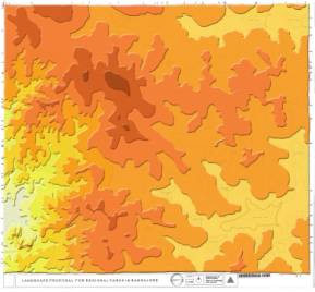
Map 1
Courtesy : Mahalakshmi Karnad (2001), Landscape Proposal for Regional Parks in Bangalore.
Water bodies and microclimate:
Water also has a warming and cooling effect. Land on the leeside of a lake will be warmer in winter and cooler in summer. It may also contribute to the humidity. The larger the body of water the larger its impact on the microclimate.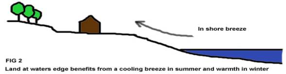
| Case Studies | up | previous | next | last |
The following prominent lakes (encircled in the Survey of India map below) were studied under the two given categories.
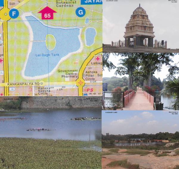
a) Urban Lakes (Lalbagh , Ulsoor, Sankey, Kempambudhi and Yediyur).
b) Suburban Lakes (Agara, Bellandur, Varthur).
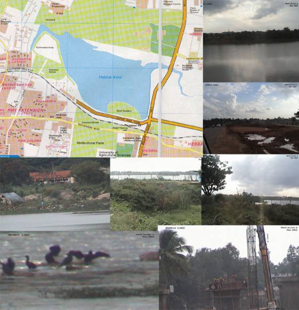
Mathikere, Hebbal and Nagavara lakes in the north and Madivala in the South were also studied.
Map source: Eicher Bangalore City map
Photographs : 3 of 68 Digital images
• Completely enclosed within the park precincts.
• Visual link from the surrounding areas and adjoining roads is nearly absent.
• This lake benefits from the extensive park area surrounding it and is a major lung space for Bangalore city It merits special treatment in order to increase public use, activities, and revenue generation.
• It has the potential to become a major tourist attraction showcasing Bangalore as a City of Lakes.
Urban Lakes Ulsoor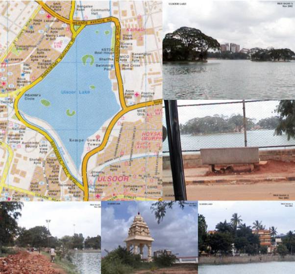
Map source: Eicher Bangalore City map
Photographs : 4 of 54 Digital images
• Is the best example in terms of relation to built form with visual links all round.
• Treatment of surrounding areas as parks and waterways.
• The open drain along Gangadhar Chetty road is a major drawback.
• Some areas of the lakefront can be terraced and developed with street furniture to enable public use.
Urban Lakes Sankey
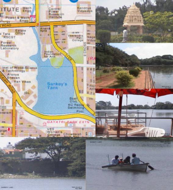
Map source: Eicher Bangalore City map
Photographs : 5 of 57 Digital images
• One of the major landmarks of Bangalore.
• Well maintained with regular and periodic desilting and deweeding.
• Ringed by built form with adequate visual linkages.
• Currently used for recreational activity like boating etc
• Development of a marina along the Sankey Road to be accessed from Gayathri Park extension by a lower level opening below the road can be explored.
• Additional landscaping and street furniture required along the accessible areas.
• Presence of institutions like Aranya Bhavan, Wood Science Institute, Indian foundation for Arts etc. on the northern side have helped to conserve the lake without encroachments etc.
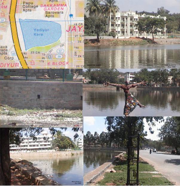
Map source: Eicher Bangalore City map
Photographs : 5 of 55 Digital images
• A lake, which has not been fully exploited by the authorities.
• It has the potential of being developed as a recreational center on the lines of Ulsoor and Sankey lakes.
• It has adequate visual linkage with the surrounding built form.
• High intensity development has been allowed on the northern side, which is too close to the waterfront. Such encroachment should be discouraged.
Urban Lakes Kempambudhi
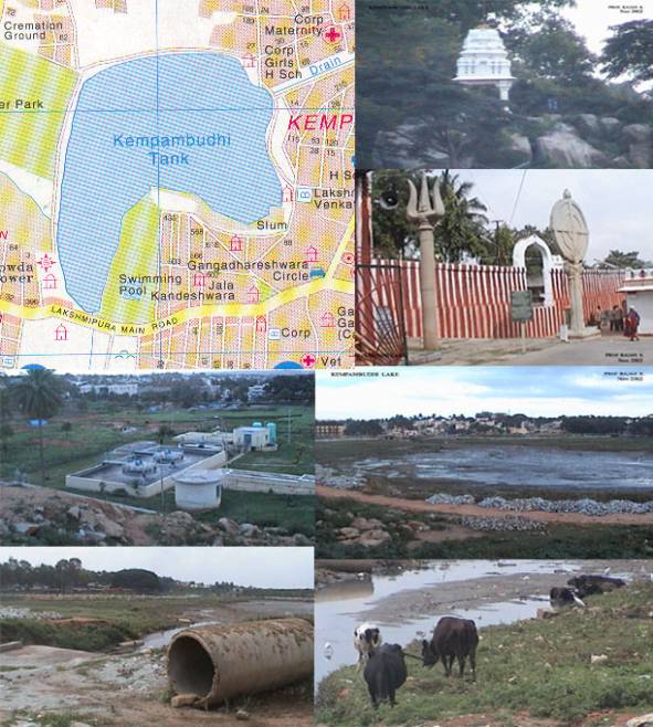
Map source: Eicher Bangalore City map
Photographs : 5 of 59 Digital images
• Historical lake of Bangalore close to the Gavigangadhareshwara temple; the tower of Kempegowda on the southwest lies in neglect and with no convenient access.
• Away from public gaze due to its location in a poorly accessible area.
• It is surrounded by the older developments pre-dating city level sewerage systems, due to which major sewage discharge occurs here.
• Feeder channels have been choked and the lake is almost dry.
• A number of slums have developed along the lakefront.
• It needs major renewal effort to revitalise the lake.
• All suburban lakes are a few kilometers away from intense development currently.
• These lakes fall in the eastern valley area of the city and form an interconnected chain.
• A part of the chain falls in the restricted defence area.
• They form part of the proposed regional park scheme.
• All the lakes receive large volumes of sewage and sullage run-off; industrial effluents are major pollutants.
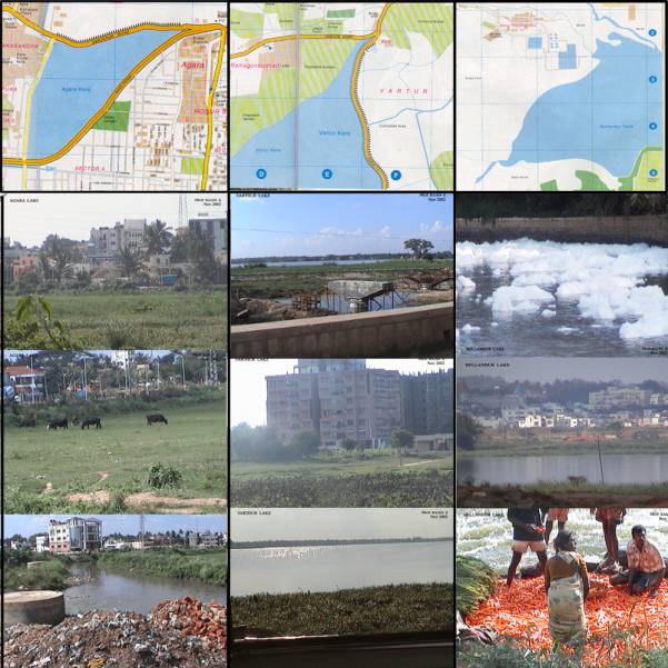
Map source: Eicher Bangalore City map
AGARA VARTHUR BELLANDUR
Photographs : 3 of 31 3 of 45 3 of 216 Digital images
Map source: Eicher Bangalore City map
Photographs : 7 of 21 Digital images
• This lake has received substantial international funding for development; small islands have been reclaimed which has attracted various bird species.
• The ring road and the flyover abut the lakefront on the southern and eastern sides.
• It is proposed to be a notified area in the near future.
| Inferences and Remedial Measures | up | previous | next | last |
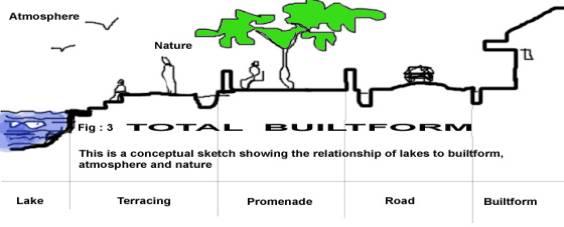
i. Lakes being cooling agents, are essential to the urban microclimate, hence the cool air should be allowed to flow unrestricted into the surrounding urban development.
ii. Visual links should be established by avoiding barriers like walls and high bunds.
iii. Religious customs of the public have to be accommodated by demarcating specific zones where activities like immersion etc. can take place without being detrimental to the lake. There has been some effort in this direction during the Ganesha Festival in both Sankey and Ulsoor lakes.
iv. Entertainment activities along the lakefronts can be promoted as a revenue generating measure.
v. Some areas of the lakefront are murky, inaccessible and inhabited by anti- social elements. Such activity can be avoided by giving free access to the public with well-landscaped terraced spaces along the lakefront.
vi. The existing legislation regarding pollution control need to be strengthened and enforced.
vii. Public participation in terms of voluntary monitoring of lakefront activities is essential; programs to promote public awareness regarding desirability of lake conservation.
viii. Lake management with a view to sustainable maintenance requires to be specific with regard to:
Development of lakes
Protecting biological resource
Monitoring and enhancing water quality
Watershed management
Provision and maintenance of facilities
Revenue generation
Rehabilitation and restoration would include deweeding, desilting, bund-formation, boundary fencing, turfing embankments, providing silt traps, promoting aquaculture, landscaping and providing facilities like toilets, dustbins, benches telephone kiosks, signage, lighting, cafes, ticketing and security.
| Bibliography | up | previous | next | last |
• Lakshman, N. Rau & Parthasarthy, M.A. Your Bangalore The Lakes , Bangalore Urban Art Commission
• Report- Comprehensive Development Plan (Revised), (1995), Bangalore Development Authority, Bangalore.
• Venkataramanan, R. (2000), Lakes in our City, How they are linked to the life of the people . Department of Forest, Government of Karnataka.
• Narendra, K.V (1993), Lakes of Bangalore, The Current Scenario , Center for Science and Technology, Bangalore.
• Michael Laurie, (1975), An Introduction to Landscape Architecture . Department of Landscape Architecture, University of Berkeley.
• Sanjay Udamale (July 2002), Transforming the lakes as urban public places . JIIA.