
 Sahyadri ENews Issues: I - LXXVIII

Eco-restoration for people, nature, and climate of a spiritual campus- Satyaloka, Andhra PradeshCite
T V Ramachandra, Bharath Setturu, Vinay
ENVIS[RP], Environmental Information System, Energy and Wetlands
Research Group,
Centre for Ecological Sciences, Indian Institute of Science -
560012
envis.ces@iisc.ac.in
tvr@iisc.ac.in Phone:
080 22933099/22933503
2.0 Materials and Method
Study Area
Satyaloka campus, Ramakuppam Mandal, Chittoor district, Andhra Pradesh: Satyaloka campus is located in Ramakuppam Mandal, Chittoor District of Andhra Pradesh and is part of the Eastern Ghats of India. The Chittoor District is situated between 12o 37' to 14o 8' N and 78o 33' to 79o 55' E with a geographical area of 15,563 sq. km (Figure 1). The average mean daily minimum and maximum temperatures are 27.9 oC and 40.3 oC during May and 18.7 oC and 29.9 oC during January. The district lies in Southern Plateau and Hills Region, North Eastern Agro-climatic Zone, and Deccan Plateau, a hot arid ecoregion. The soil of the district is drained by Swarnamukhi, Kalangi, Araniar, Kushastali, Palar, Papagni, Cheyyeru, Upputeru (Pennar) rivers. The district has rich minerals such as Low-grade steatite, Soapstone, Granite (black, pink, and grey). The forest cover has accounted as 29% of the geographical area, with rich flora and fauna species. Venkateshwara National Park and Koundinya Wildlife Sanctuary are sheltering rich faunal species. The district has a population of 4,178,061 (2011), with a literacy of 72.36%. The district is divided into three revenue divisions, i.e., Chittoor, Madanapalle, and Tirupati, with 20 blocks or 66 Mandals covering 1540 Revenue villages in 1394 Gram panchayats. The district is known for its tourism activities and has world-famous Tirupati/Tirumala, Kalahasth, and Kanipakam temples.
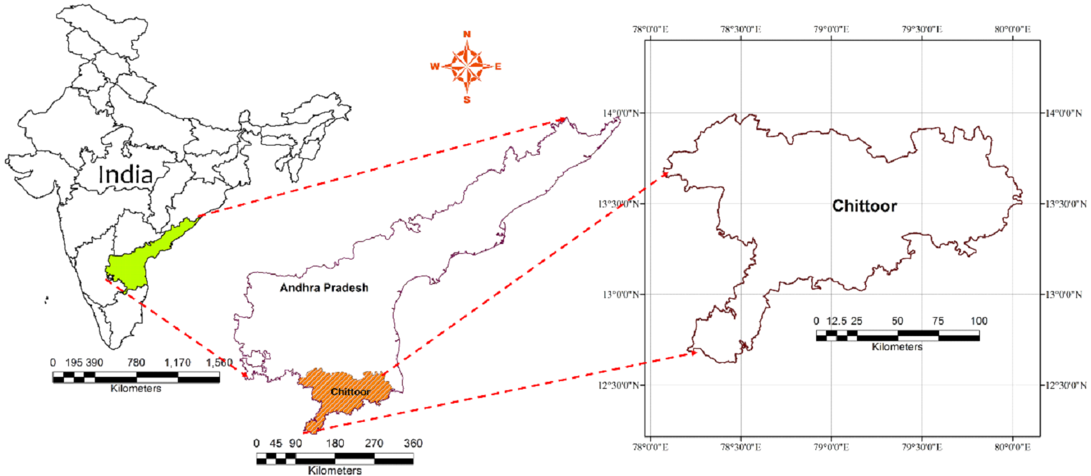
Figure1. Chittore district, Andhra Pradesh state
Mandals in the Chittoor district are listed in Table 1. Figure 2 illustrates the land use pattern in the district, and land use statistics are presented in Table 2. The share of land uses is presented in Figure 3, which highlights that a major part of the district is under agriculture (croplands and horticulture) and allied activities. Chittoor district is known for horticulture crops and has major markets of tomatoes, mangoes, grains, sugarcane, and peanuts.
Table 1. Mandals in Chitoor district, Andhra Pradesh
Irala |
Kambhamvaripalle |
Kalakada |
Kalikiri |
Karvetinagar |
Kuppam |
Kurabalakota |
K.V.B.Puram |
Gangavaram |
Gangadhara Nellore |
Gudipala |
Gurramkonda |
Gudupalle |
Chandragiri |
Chittoor |
Chinnagottigallu |
Chowdepalle |
Thamballapalle |
Thavanampalle |
Tirupati (Rural) |
Tirupati (Urban) |
Thottambedu |
Nagari |
Nagalapuram |
Narayanavanam |
Nindra |
Nimmanapalle |
Palamaner |
Pakala |
Palasamudram |
Pichatur |
Pileru |
Punganur |
Puttur |
Pulicherla |
Puthalapattu |
Pedda |
Thippasamudram |
Peddapanjani |
Peddamandyam |
Penumuru |
Bangarupalem |
Baireddipalle |
B.Kothakota |
Buchinaidu |
Kandriga |
Madanapalle |
Mulakalacheruvu |
Yadamarri |
Yerpedu |
Yerravaripalem |
Ramakuppam |
Ramachandrapuram |
Ramasamudram |
Renigunta |
Rompicherla |
Vadamalapeta |
Varadaiahpalem |
Valmikipuram |
Vijayapuram |
Venkatagirikota |
Vedurukuppam |
Srirangarajapuram |
Srikalahasti |
Satyavedu |
Santhipuram |
Sodam |
Somala |
Table 2. Land use details of Chittor district, Andhra Pradesh
Land Use category |
Area |
|
Hectare |
Percent |
|
Evergreen / Semi Evergreen - Dense |
23 |
0.00 |
Deciduous (Dry/Moist/Thorn)-Dense |
141620 |
9.35 |
Deciduous (Dry/Moist/Thorn)-Open |
138689 |
9.15 |
Tree Clad Area-Dense |
6199 |
0.41 |
Tree Clad Area-Open |
1498 |
0.10 |
Forest Plantation |
5873 |
0.39 |
Scrub Forest |
132088 |
8.72 |
Salt affected land |
7736 |
0.51 |
Gullied land |
2332 |
0.15 |
Dense scrub |
85502 |
5.64 |
Open scrub |
74367 |
4.91 |
Riverine |
23 |
0.00 |
Barren Rocky/Stony waste |
24424 |
1.61 |
Waterbodies |
71997 |
4.75 |
Agriculture |
764626 |
50.47 |
Horticulture |
16468 |
1.09 |
Built-up |
41605 |
2.75 |
Total Area |
1515070 |
100.00 |
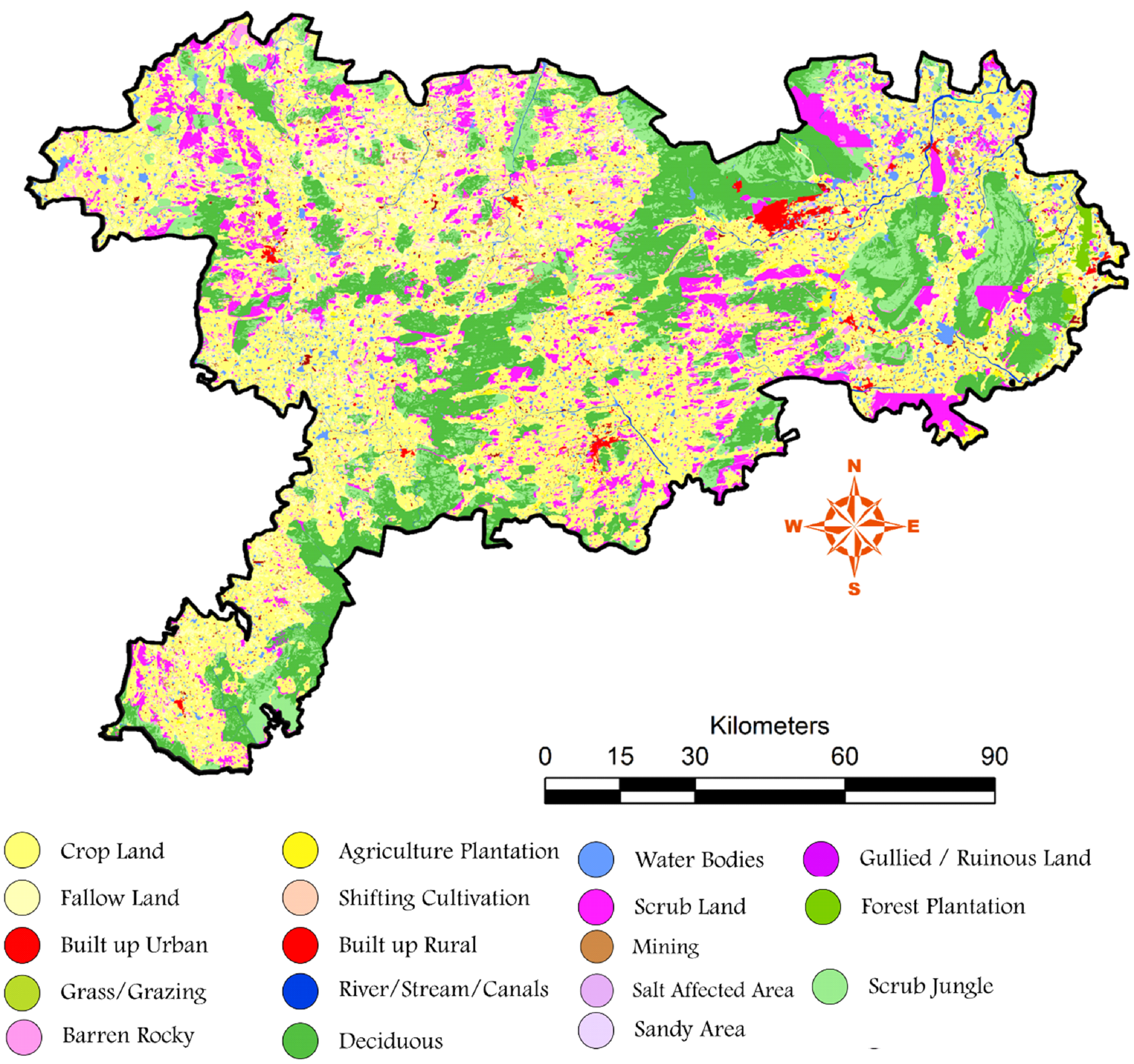
Figure 2. Land uses in the Chittoor district
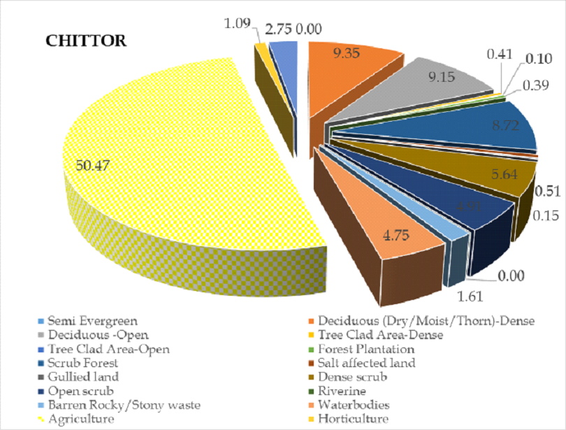
Figure 3. Land use pattern of Chittor district