
 Sahyadri ENews Issues: I - LXXVIII

Centenary Pond at Indian Institute of Science - Optimal Rain Water Harvesting at Decentralised levelCite
Ramachandra T V
ENVIS[RP], Environmental Information System, Energy and Wetlands
Research Group,
Centre for Ecological Sciences, Indian Institute of Science -
560012
envis.ces@iisc.ac.in
tvr@iisc.ac.in Phone:
080 22933099/22933503
SYNOPSIS
Sustainable management of natural resources has attained the attention of decision makers in the early 20th century consequent to the crisis faced by the society due to unplanned developmental activities. The anthropogenic activities have affected the quality and quantity of natural resources, which is evident from the disappearance of waterbodies, degraded catchments and increased organic pollutants in waterbodies, which necessitated optimal resource planning. Spatial and temporal tools such as Geographic Information System (GIS) are helpful in analyzing the spatial data. To meet the growing demand for water due to burgeoning population, planners attention is diverted towards alternatives such as rainwater harvesting, treatment of waste water, recycling, etc. Rainwater harvesting and artificial recharge of ground water augments the ground water storage and improves the condition of the other water resources in the vicinity. Rainwater harvesting forms one of the most cost-effective methods for improving the water resources for domestic water requirements.
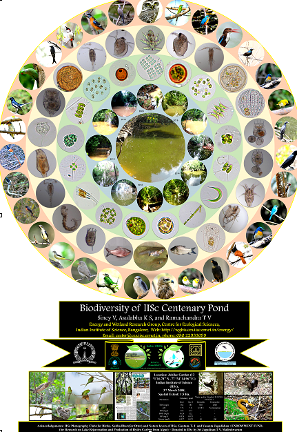
This paper analyses the feasibility of utilisation of geoinformatics in the design of a harvesting structure at Indian Institute of Science (IISc) campus. Indian Institute of Science (IISc) covers an area of 180 ha and forms a part of Sankey lake catchment (located to south east of the Institute). The location and size of harvesting structure was identified with a detailed investigation of the land use pattern, hydrological analyses, catchment delineation, and identification of potential water demand areas. Ecological, economical, social and technical aspects were also considered. Harvesting structure with an area of 1.5 ha and a depth of about 3m can hold about 48,000 m3 of water. This was found sufficient to meet the requirement of swimming pool, gardening and toilet usage in the campus. Topographical analyses with the help of Digital Elevation Model (DEM) identified suitable location of harvesting structure at eastern side of the campus. About 1.5 ha land is available in this region to construct harvesting structure. Hydrological analyses were carried out taking into account various land uses (sub-catchment delineation) to assess the water yield in the eastern part of the campus. The cumulative annual yield of the catchment ranged from 0.4 million m3 to 0.8 million m3. Pond was created at IISc campus in 2008 and is now a home for various diverse biota (Otter, birds, reptiles, etc.) and is popularly known as Centenary Pond.