Human-Wildlife Conflicts
in Northern Western Ghats, India
T V Ramachandra, Sonam Latwal,
Bharath Sethuru Cite
ENVIS[RP], Environmental Information System, Energy and Wetlands
Research Group,
Centre for Ecological Sciences, Indian Institute of Science - 560012
envis.ces@iisc.ac.in
tvr@iisc.ac.in Phone:
080 22933099/22933503
Study Area
The Western Ghats (WG), also known as "Sahyadri" is a region
of high biodiversity along the west coast of India is about
45-65 million years old. It originates from the south of
Tapti River near Gujarat and Maharashtra border, extends up
to Kanyakumari, at the southernmost tip of the Indian
Peninsula. WG covers the parts of Gujarat, Maharashtra, Goa,
Karnataka, Kerala, and Tamil Nadu with an area of 1, 64000
sq. km. hills of the Northern Western Ghats (NWG) are lower,
with an average elevation of 1, 220 m, than hills of
Southern Western Ghats (SWG). Palghat Gap which lies at the
Tamil Nadu/Kerala border between Nilgiri Hills and Annamalai
Hills, is the only which interrupts the massive mountain
chain of WG's. Nilgiri Hills ("Blue Mountains") in Southern
WG's is the meeting point of the Western Ghats with the
Eastern Ghats.
WG constitutes a watershed of perennial rivers, which
drain 40% of the Indian sub-continent, and provide
hydrological services that sustain food security. The
landscape of northern WG has drier climatic conditions and
the evergreen forest part of WG's is less disturbed, and
therefore, many original Gondwana relics, Himalayan relics
and other trans migrants are reported from these forest
areas.
WG's exhibits a high degree of endemism. The region is
one of the eight "Hottest Biodiversity Hotspots". World Wide
Fund for Nature (WWF) designated 200 ecoregions in which
SWG's moist forests and the rivers and the streams fall
under Critically Endangered Category. Similarly, WG is
identified as one of the important areas of freshwater
biodiversity by World Conservation Monitoring Centre (WCMC).
Floral and Faunal Diversity of WG
The flora of WG comprises about 12,000 species ranging
from unicellular cyanobacteria to angiosperms. In this
spectrum, the flowering plants constitute about 27% of
Indian flora with 4500+ species, of which about 1,500
species are endemic (Gadgil et al., 2011) . Plants such as
Aristolochia indica, Arundinella metzii, Canthium
parviflorum, Smithia hirsuta, Flacourtia Montana, Geissaspis
cristata, Crotalaria lutescens. Rhynchospora wightiana,
Trees such as Artocarpus heterophyllus, Artocarpus hirsute,
Caryota urens, Garcinia indica, Holigarna arnotiana, Hopea
ponga, Hydnocarpus laurifolia, Ixora brachiata,
Lagerstroemia microcarapa, Litsea laevigata, Mammea suriga,
Memecylon talbotianum, Myristica malabarica, Polyalthia
fragrans, Vateria indica etc., are endemic to the Western
Ghats. The WG exhibits rich and diverse fauna, including
birds, fishes, reptiles, mammals, and amphibians among
vertebrates. It was reported that around 500 species of
endemic fishes, amphibians, reptiles, birds, and mammals
exist in WG (Gadgil et al., 2011). Among mammals, Chiroptera
is the largest order (50 species). Largest bird diversity of
WG are found in evergreen, and moist deciduous, mid-altitude
forests and 16 species are reported to be endemic to this
region. Among Amphibian species, Rhachophoridae is the most
diverse family and is also known as "the old world tree
frogs", and 159 species are endemic to this region. Snakes
are the majority of reptiles found in WG, and 61% (124
species) are endemic to this region. Out of all the faunal
species found in WG, 200 species come under the globally
threatened category.
East and West flowing rivers of Western Ghats
The west flowing rivers consists of small river basins
lying to the South of the Krishna Basin (except Cauvery
Basin), and drains into the Arabian Sea. The basin covered
WG parts of Goa, Maharashtra, Kerala, Karnataka, and Tamil
Nadu states and is located in the South-West corner of
Peninsular India. There are 31 small river basins in these
regions: Bhogeshwari, Netravathi, Aghanashini, Periyar,
Pamba, Manimala, etc. They originate from the high mountains
of WG and have steeply high banks, which rarely cause any
flood or overflow.
East flowing rivers consist of many small basins of
Peninsular India lying to the South of the Krishna basin
(except Cauvery), and drains into the Bay of Bengal. The
basin covers areas of Andhra Pradesh, Tamil Nadu,
Puducherry, and Karnataka.
Climate
Altitude gradients and distance from the equator have
influenced WG's climatic conditions. The average annual
temperature is around 15 o֯C and the mean temperature ranges
from 20 oC to 24 o֯C, from south to north. Elevations of 1,500
m and above in the north and 2,000 m and above in the south
have a more temperate climate. 3,000-4,000 mm. is the
average rainfall in this region. Maximum rainfall is in
July-August. From Wayanad to the Mahabaleshwar region,
annual rainfall exceeds 5000 mm over the entire region. WG
regions have low elevation but still, receive high rainfall.
Northern Western Ghats
The spatial extent of Northern Western Ghats (NWG) is
65, 000 sq. km, extending from Gujarat to Goa (Figure 2)
accounts for 33.75% of the total extent of Western Ghats
(WG). There are five districts covering parts of NWG of
Gujarat (NWGG), namely Dangs, Valsad, Surat, Tapi, and
Navsari. In NWG of Maharashtra (NWGM) there are 12 districts
covering parts of NWGM, namely; Ahmednagar, Dhule, Kolhapur,
Nandurbar, Nashik, Thane, Pune, Raigarh, Ratnagiri, Sangli,
Satara, and Sindhudurg. NWGM has many ecological
characteristics, and rocky plateaus are one of them. NWG of
Maharashtra represents biogeographic Zone 5 with two
provinces, i.e., 5A (WG Malabar Plains) and 5B (Western
Ghats Mountains). There are total 67 sacred groves within
the NWG of Maharashtra. NWGM has seven wildlife sanctuaries
in an area of 1593.54 sq. km. Sahyadri Tiger Reserve, with
an area of 732.52 sq. km, including parts of Koyna and
Chandoli WLS, is the only tiger reserve in this region. The
corridor between Radhanagari and Chandoli forests sustains
20 tigers. Eight major rivers come out of this region. The
total forest area of NWGM is 18,966 sq. km (FSI, 2017),
including 67 sacred groves. Four Environmentally Sensitive
Zones are there within NWGM. Two districts of Goa are part
of NWG (NWGG), i.e., North Goa and South Goa.
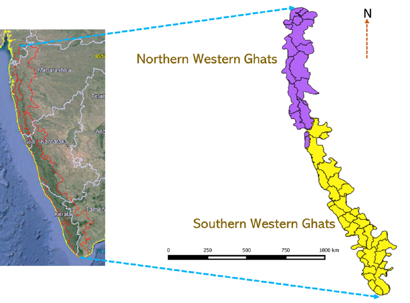
Figure 2. Western Ghats (North and South) with district
boundaries.
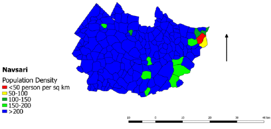
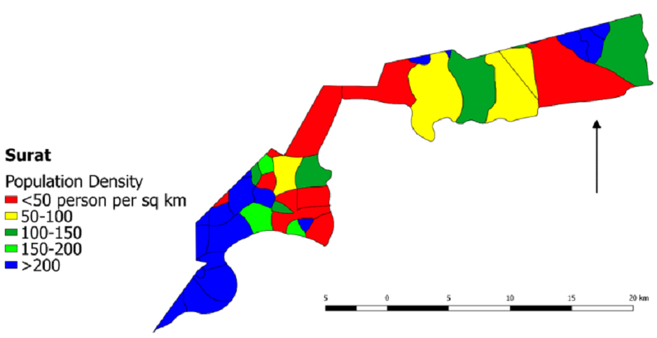
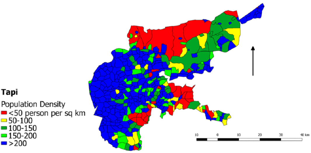
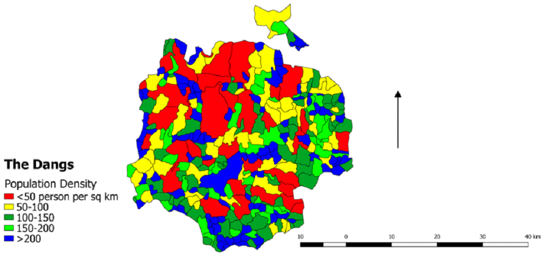
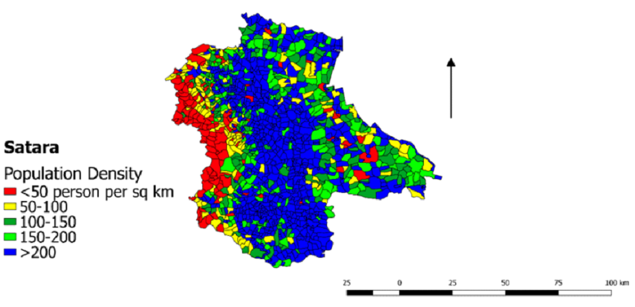
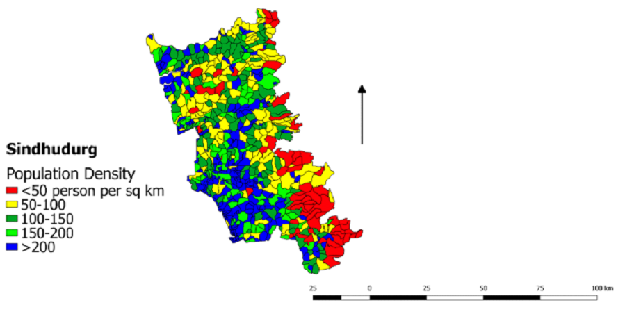
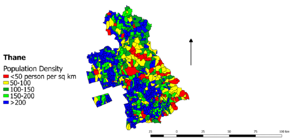
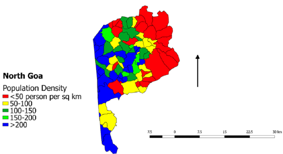
Population Density
Population density is related to persons present over a
geographical area. Population density changes represent
employment opportunities, educational facilities, industrial
development, economic development, social environment,
health and recreation, political, social institutes of
education, and the exercise of residential preferences
(Barakade, 2011) . Population data for NWG was collected from
the Census of India, 2011, portal
(http://censusindia.gov.in).
District wise population density estimation:
Table 1: Population Density of Northern Western Ghat
Districts
| Northern Western Ghats |
⦁ Gujarat |
|
|
Highest Population density (person per sq km):
Bansda Taluk
Bansda Village (Highest): 2811
Sadad Devi (Lowest): 40
|
|
|
Highest Population density (person per sq km):
Mandvi Taluk
Jamankuva Bar Village (Highest): 3228
Rundha Village (Lowest): 0 Lowest Population
Density: Umarpada Taluk
|
|
|
Highest Population density (person per sq km):
Vyara Taluk
Varjakhan Village (Highest): 925
Barmada Village (Lowest): 0
Lowest Population Density: Songadh Taluk
|
| Districts |
Comments |
|
|
Highest Population density (person per sq
km): Taluk
Satpura Village (Highest): 3719
Wawanda and Jamanpada Village (Lowest): 0
Lowest Population Density: Songadh Taluk
|
|
|
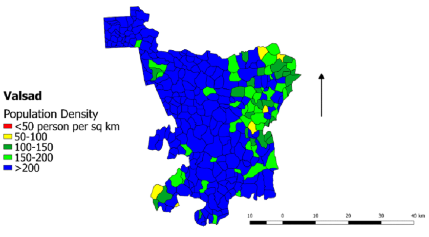
Highest Population density (person per sq
km): Kaprada Taluk
Nana Pondha Village (Highest): 1065
Piproni Village (Lowest): 51
Lowest Population Density: Dharampur Taluk
|
| Northern Western Ghats |
⦁ Maharashtra |
| Districts |
Comments |
|
|
Highest Population density (person per sq
km): Shirampur Taluk
Shrirampur Village (Highest): 4989
Kanhegaon Village (Lowest): 40
Lowest Population Density: Nagar Taluk
|
|
|
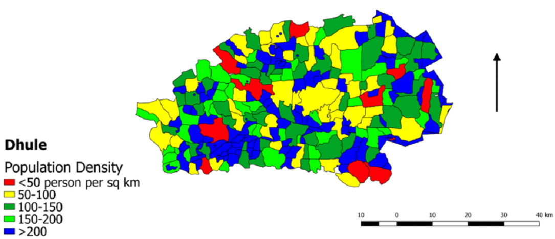
Highest Population density (person per sq
km): Sakri Taluk
Bodakikhadi Village (Highest): 1353
Raikot Village (Lowest): 13
Lowest Population Density: Dhule Taluk
|
|
|
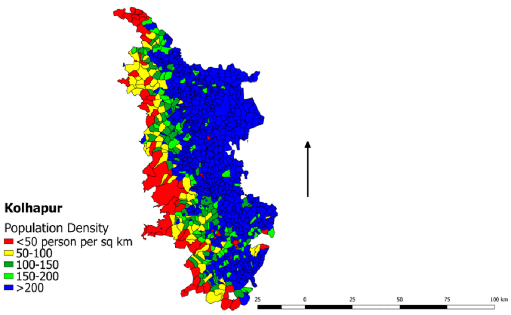
Highest Population density (person per sq
km): Karvir Taluk
Kgadewadi Village (Highest): 4223
Yevati Village (Lowest): 0
Lowest Population Density: Bavda Taluk
|
|
|
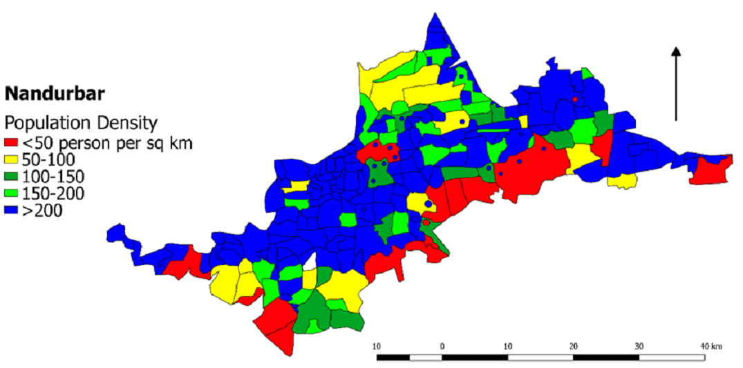
Highest Population density (person per sq
km): Nawapur Taluk
Bhadwad Village (Highest): 8446
Adalse, Umarvihir Village (Lowest): 0
Lowest Population Density: Nandurbar Taluk
|
|
|
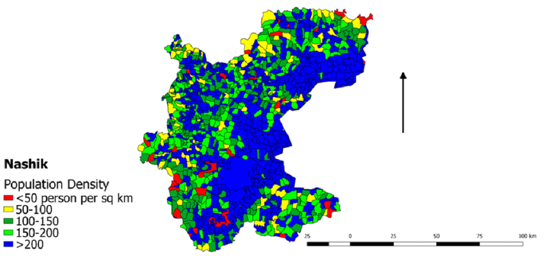
Nashik Highest Population density (person
per sq km): Sinnar Taluk
Sangavi Village (Highest): 8384
Bhojapur Village (Lowest): 0
Lowest Population Density: Baglan Taluk
|
|
|
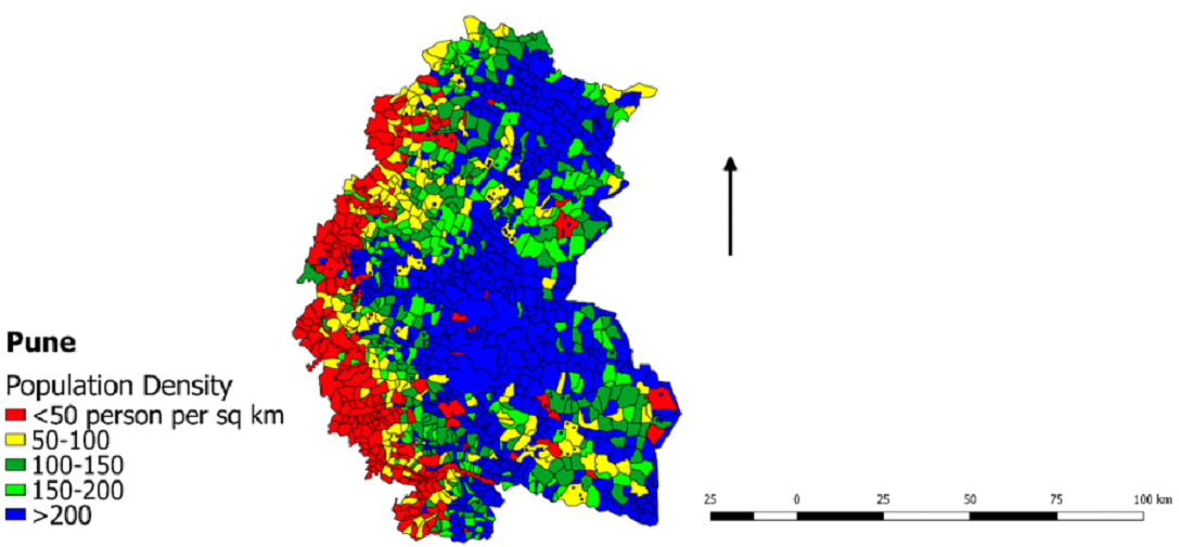
Highest Population density (person per sq
km): Baramati Taluk
Kutwalwadi Village (Highest): 5283
Hol Villagec(Lowest): 0
Lowest Population Density: Baramati Taluk
|
|
|
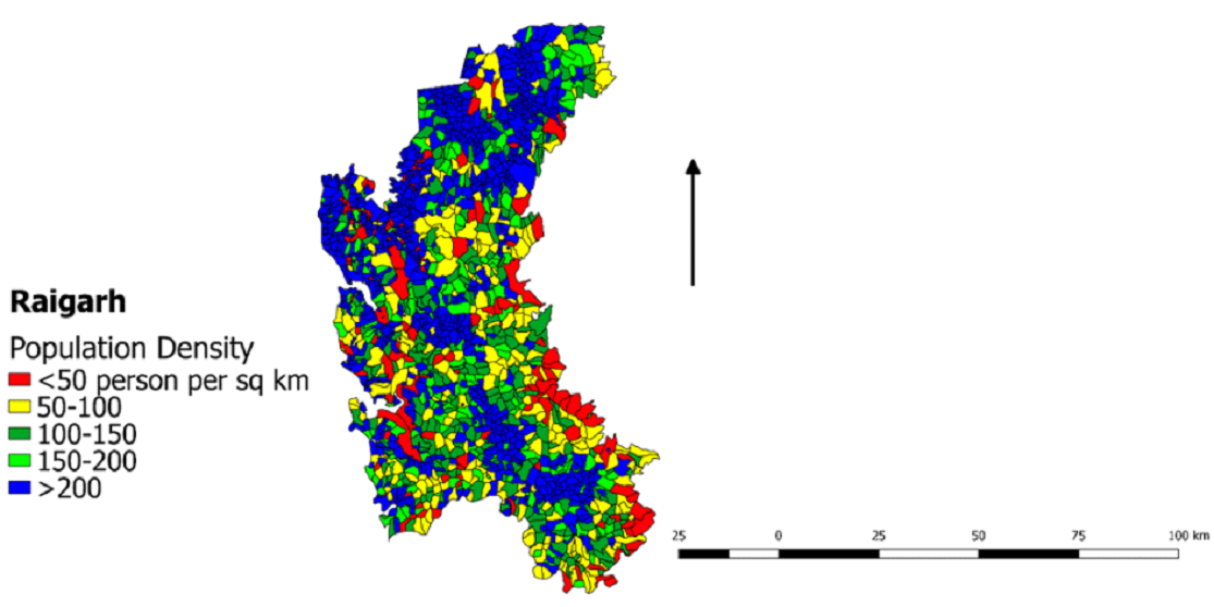
Highest Population density (person per sq
km): Mangaon Taluk
Chinchali Village (Highest): 459
Aba Devi Village (Lowest): 35
Lowest Population Density: Roha Taluk
|
|
|
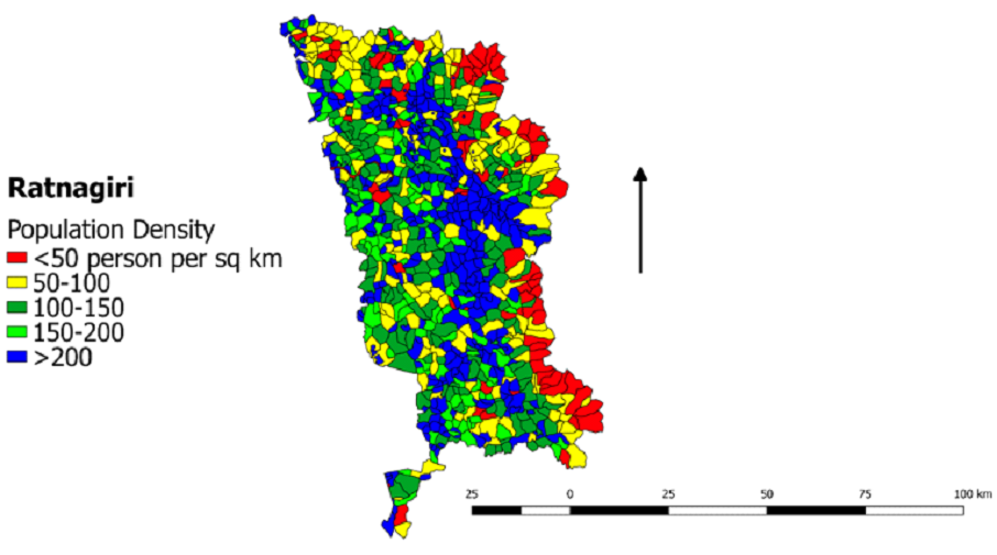
Highest Population density (person per sq
km): Ratnagiri Taluk
Ganeshgule Village (Highest): 6876
Dhopatwadi (Lowest): 0
Lowest Population Density: Guhagar Taluk
|
|
|
Highest Population density (person per sq
km): Walwa Taluk
Macchindra Gad Village (Highest): 3519
Ahirwadi village (Lowest): 67
Lowest Population Density: Khanapur Taluk
|
|
|
Highest Population density (person per sq
km): Karad Taluk
Malkapur Village (Highest): 3572
British Shirwade village (Lowest): 67
Lowest Population Density: Jaoli Taluk
|
|
|
Highest Population density (person per sq
km): Malwan Taluk
Nawabag Village (Highest): 1443
Chipi village (Lowest): 69
Lowest Population Density: Dodamarg Taluk
|
|
|
Highest Population density (person per sq
km): Murbad Taluk
Deogaon Village (Highest): 8834
Gorakhgad village (Lowest): 53
Lowest Population Density: Shahapur Taluk
|
| Northern Western Ghats |
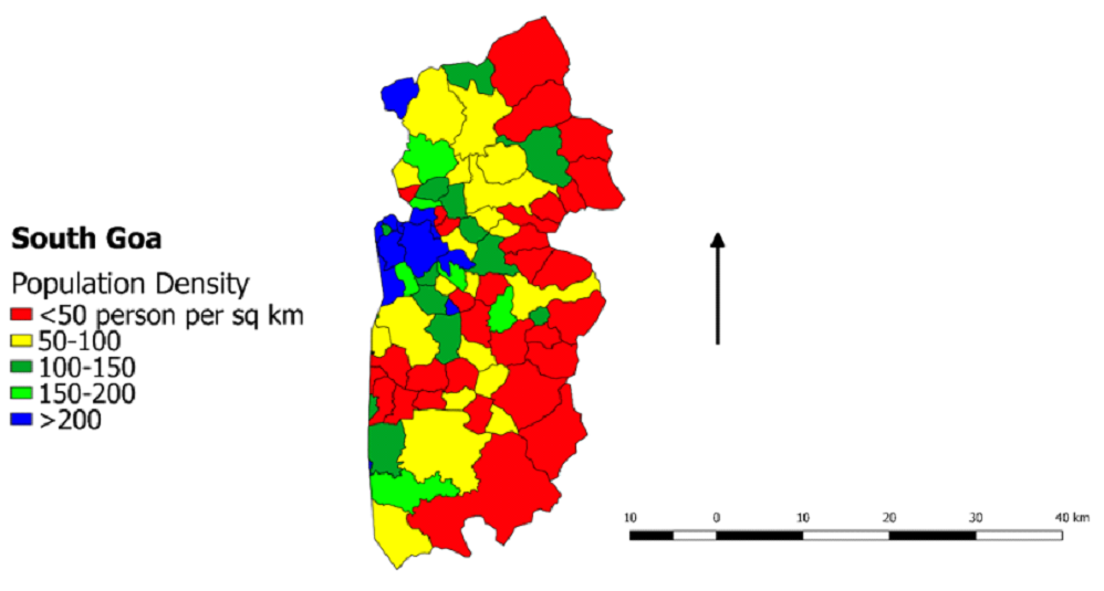
⦁ Goa |
|
|
Highest Population density (person per sq
km): Bicholim Taluk
Velguem Village (Highest): 704
Surla village (Lowest):203
Lowest Population Density: Satari Taluk
|
|
|
Highest Population density (person per sq
km):Quepem Taluk
Xelvona Village (Highest): 761
Mangal village (Lowest):26
Lowest Population Density: Sanguem Taluk
|
Remote sensing data acquisition for LULC Analysis
Remote sensing data (LANDSAT) were downloaded from
United States Geological Survey (USGS) archive (http://earthexplorer.usgs.gov/
). Landsat 8 Operational Land Imager and Thermal Infrared
Sensor (OLI/TIRS) imageries of 30 m resolution were acquired
in the pre-monsoon season between 1 January 2018 to 31 March
2018 and cloud-free were chosen for LU analyses.
Preprocessing
The Landsat 8 OLI data obtained for all districts of NWG
for the time 2018 in 7 layers (TIFF format), were
preprocessed by extracting bands, stacked in GRASS 7.4, and
generated false-color composite (FCC) images.
Image Classification
A supervised classifier based on the Gaussian maximum
likelihood algorithm (Lillesand et al., 2008; Bharath, and
Ramachandra, 2021) is used LU classification of NWG into ten
categories - semi-evergreen, moist deciduous, dry deciduous,
scrubland, waterbody, horticulture, plantation, cropland,
open area, and built-up. Accuracy of the classified image is
assessed through producer accuracy, user accuracy, overall
accuracy, and kappa statistics.
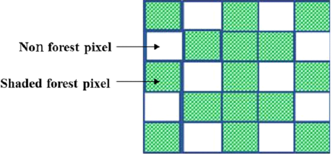
Forest fragmentation implementation
fragmentation analysis has been done (Ritters et al.,
2000; Ramachandra et al., 2016) by computing Pf and Pff
values using a 5×5 moving window (Figure 3) with the
classified land use data of forest category.
Pf=Proportion of number of forest pixels/Total
number of non-forested pixels in the window
Pff=Proportion of number of forest pixel
pairs/Total number of adjacent pairs of at least one forest
pair
Figure 3. KERNEL (5×5) for computation of Pf and Pff
Table 2. Forest fragmentation categories and their
description
| S.No. |
Fragmentation Categories |
Description |
| 1. |
Interior Forest |
(Pf = 1), All of the pixels surrounding the
center pixel are forest
|
| 2. |
Perforated Forest |
(Pf > 0.6 and Pf - Pff > 0), Most of the pixels
in the surrounding area are forested, but the
center pixel appears to be part of the inside
edge of a forest patch
|
| 3. |
Patch Forest |
(Pf < 0.4), Pixel is part of a forest patch on a
non-forest background
|
| 4. |
Edge Forest |
(Pf > 0.6 and Pf - Pff < 0), Most of the pixels
in the surrounding area are forested, but the
center pixel appears to be part of the outside
edge of forest
|
| 5. |
Transitional Forest |
(0.4 < Pf < 0.6), About half of the cells in the
surrounding area are forested and the center
forest pixel may appear to be part of a patch,
edge, or perforation depending on the local
forest pattern
|
| 6. |
Undetermined Forest |
(Pf>0.6 and Pf=Pf) most of the pixels in the
surrounding area are forested, but this center
forest pixel could not be classified as being
either perforated or edge
|
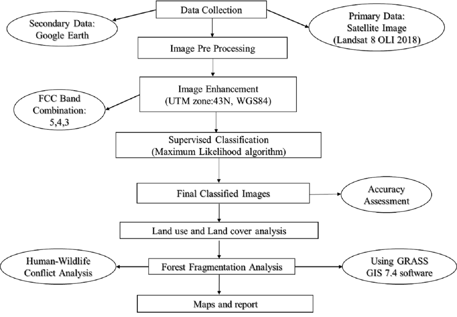
Human-Animal Conflict
After performing supervised classification and
assessment of forest fragmentation for each district of NWG,
human-animal conflict locations were compiled from field and
literature. Details of the human-animal conflict were
collected from published literature in peer-reviewed
journals (sciencedirect.com), online portals (google
scholar), previously published literature, newspaper, etc.
Details include major conflict animals, economic loss to
humans, details of compensation for crop and livestock
depredation, and also the villages and forest reserves with
the recurring instances of conflicts. Figure 4 elucidates
the framework adopted in the study to investigate
human-animal conflicts
Figure 4. Framework used
|