Results and
Discussion
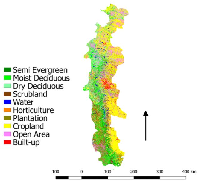
Land Use Analysis
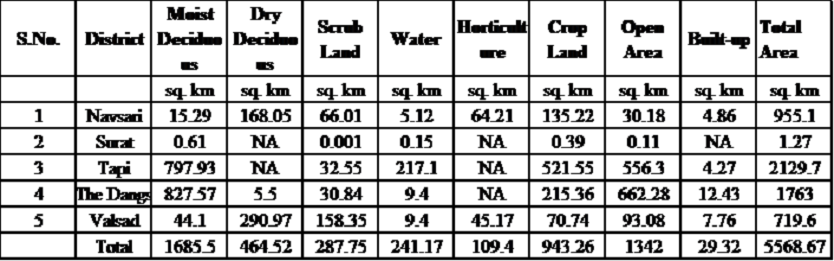
Table 3. Land use analysis of Gujarat part of NWG
| Northern Western Ghats |
Comments
|
 |
Among all the 3 states of NWG, Maharashtra parts of
NWG has least semi-evergreen forests, moist
deciduous (8850.93Km2), and dry deciduous
(7500.18Km2). SE forests are almost
absent in
Gujarat part of NWG. Goa part of NWG have
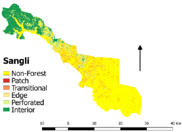
441.5Km2
SE and 148.3 Km2 scrubland forests.
|
| ⦁ NWG: District of Gujarat |
Statistics (sq. km) |
 |
Moist Deciduous: 0.61
Scrub Land: 0.001
|
 |
Moist Deciduous: 15.29
Dry Deciduous: 168.05
Scrub Land: 66.01
|
 |
Moist Deciduous: 827.57
Dry Deciduous: 5.5
Scrub Land: 30.84
|
 |
Moist Deciduous: 797.93
Scrub Land: 32.55
|
 |
Moist Deciduous: 44.1
Dry Deciduous: 290.97
Scrub Land: 158.35
|
 |
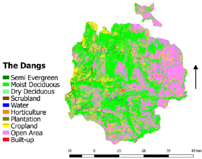
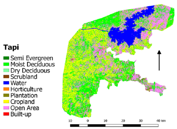
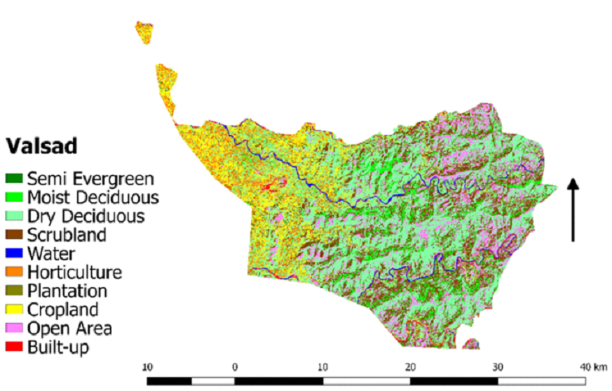
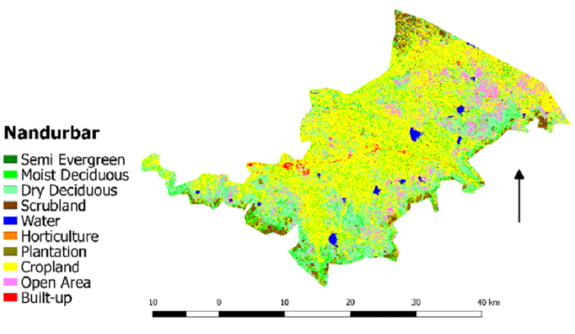
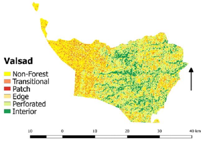
The Dangs have 827.57Km2 land area under
moist
deciduous, Valsad have high dry deciduous
(290.97Km2) and scrubland forests
(158.35Km2).
|
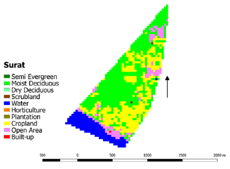
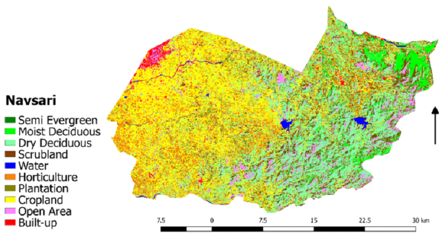
The land use pattern of the Gujarat parts of NWG of Gujarat
has been studied by classifying it into ten major categories.
Forest categories include semi-evergreen, moist deciduous, dry
deciduous, and scrubland. From table 3, it is seen that in 2018
among forest categories, around 1685.5 Km
2 area of
Gujarat is
occupied by moist deciduous forests, followed by semi-evergreen
and scrubland. Moist deciduous and semi-evergreen forest areas
showed less extent due to the demand for land, forest resources,
and economic crops. Among all the districts of NWG of Gujarat,
The Dangs showed the spatial extent of moist deciduous forests,
around 46.93 % (827.57 Km
2), due to the presence of
Purna
Wildlife Sanctuary in the region, which has moist and dry
deciduous forest types. Scrubland is more in Valsad district,
i.e., around 158.35 Km
2 (22.01%). The main reasons
for the
decrease in forest cover are shifting cultivation, biotic
pressure, diverting forest lands into non-forest lands, and
expansion of tree cover outside forest areas (Athreya et al.,
2007). Gujarat's total forest cover is 14,757 Km
2 in
2017 in a
geographical area of 196,244 Km
2 (FSI, 2017), out of
which the
WG area of Gujarat is about 5,568.67 Km
2 having a
forest cover
of 2,150 Km
2. Among non-forest categories, land use
in NWG of
Gujarat is mainly occupied by cropland (943.26 Km
2)
due to an
increase in agriculture expansion. Non-forest categories include
cropland, horticulture, plantation, built-up and open area. It
can also be seen that the 286.7 Km
2 area in the WG
region of
Gujarat state is occupied by open area (1342 Km
2),
followed by
horticulture which occupies 109.4 Km
2 and built-up
area, 7.29
Km
2. Built-up in Tapi district is about 217.1 Km
2,
around 10.19%
of the total area. Among non-forest categories (Table 4) open
area is more around 1342 Km
2 (24.1%), followed by
cropland and
horticulture. The conversion of land for alternative land use
patterns is due to the expansion of agricultural and development
activities.
Table 4. Land use statistics of Gujarat parts of NWG
(2018)
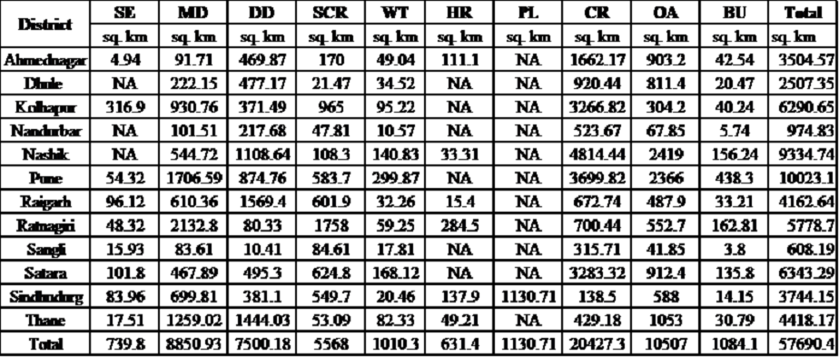
Table 5. Land use analysis of Maharashtra part of NWG
| ⦁ NWG: Districts of Maharashtra |
Statistics |
 |
Moist Deciduous: 101.51
Dry Deciduous: 217.68
Scrub Land: 47.81
|
 |
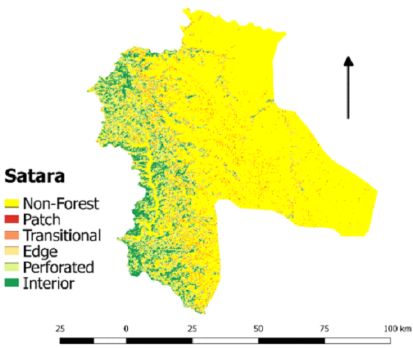
Moist Deciduous: 222.15
Dry Deciduous: 477.17
Scrub Land: 21.47
|
 |
Moist Deciduous: 544.72
Dry Deciduous: 1108.64
Scrub Land: 108.3
|
 |
Semi Evergreen: 17.51
Moist Deciduous: 1259.02
Dry Deciduous: 1444.03
Scrub Land: 53.09
|
 |
Semi Evergreen: 4.94
Moist Deciduous: 91.71
Dry Deciduous: 469.87
Scrub Land: 170
|
 |
Semi Evergreen: 54.32
Moist Deciduous: 1706.59
Dry Deciduous: 874.76
Scrub Land: 583.7
|
 |
Semi-Evergreen: 96.12
Moist Deciduous: 610.36
Dry Deciduous: 1569.4
Scrub Land: 601.9
|
 |
Semi Evergreen: 101.8
Moist Deciduous: 467.89
Dry Deciduous: 495.3
Scrub Land: 624.8
|
 |
Semi Evergreen: 48.32
Moist Deciduous: 2132.8
Dry Deciduous: 80.33
Scrub Land: 1758
|
 |
Semi Evergreen: 83.96
Moist Deciduous: 699.81
Dry Deciduous: 381.1
Scrub Land: 549.7
|
 |
Semi Evergreen: 15.93
Moist Deciduous: 83.61
Dry Deciduous: 10.41
Scrub Land: 84.61
|
 |
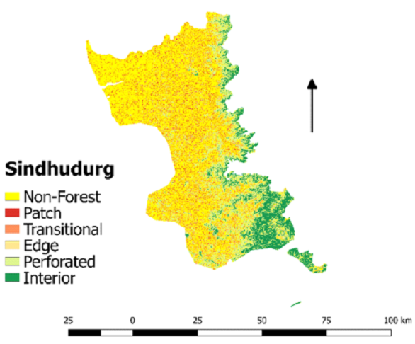
Semi Evergreen: 316.9
Moist Deciduous: 930.76
Dry Deciduous: 371.79
Scrub Land: 965
|
 |
Comments
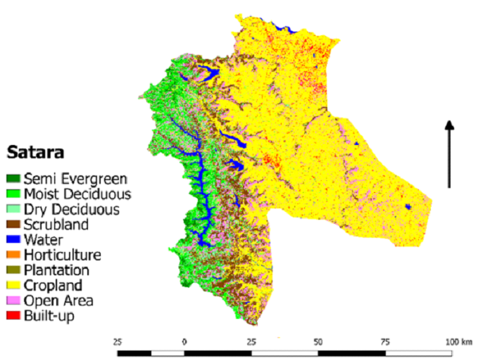
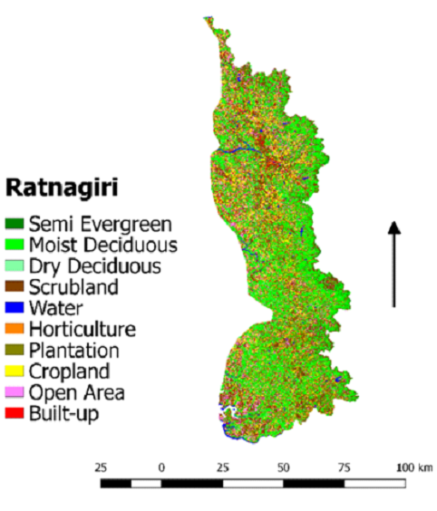
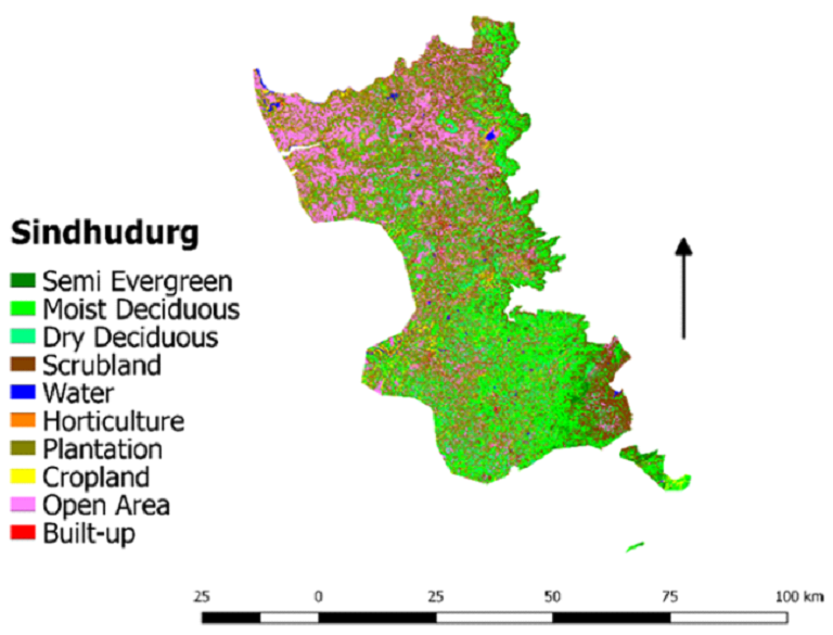
Kolhapur has 316.9Km2 area under SE,
followed by
Satara (101.8Km2), and Raigarh
(96.12Km2). MD
(2132.08Km2) is more in Ratnagiri and dry
deciduous
areas (1569.4Km2) are more under Raigarh.
Scrubland
(1758Km2) is more under Ratnagiri.
|
Table 6. Land use statistics in Maharashtra parts of NWG
(2018)
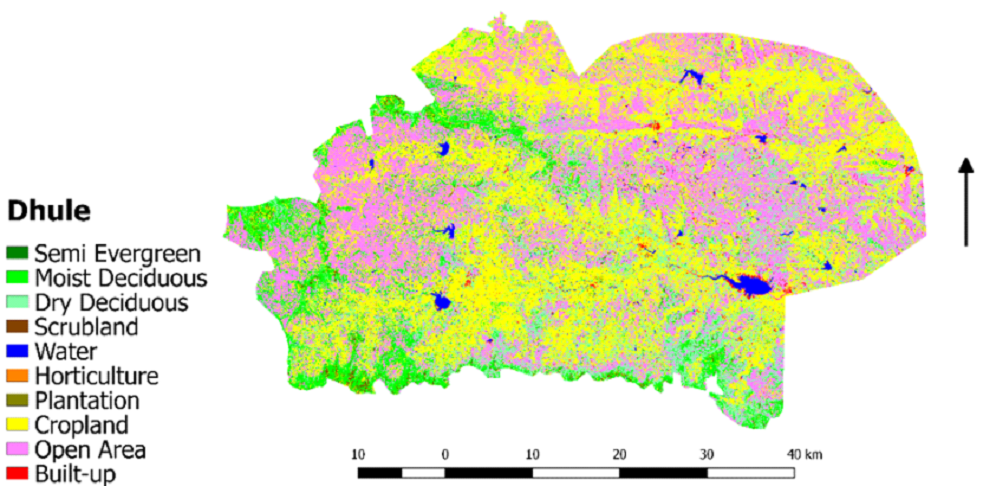
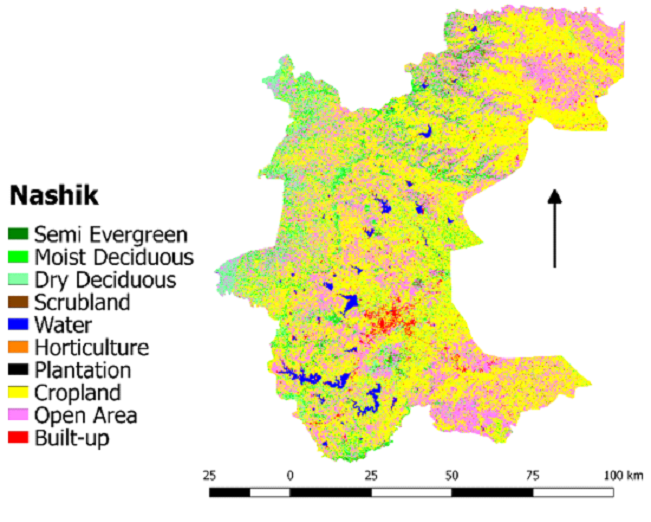
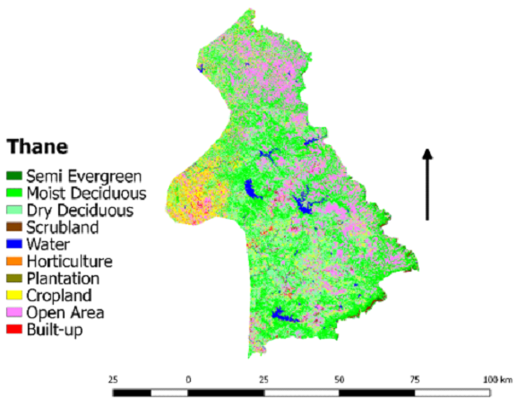
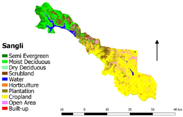
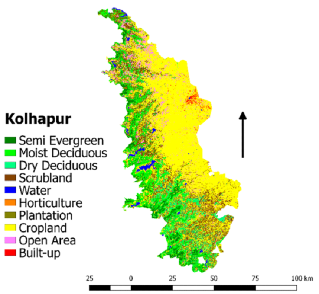
The land use pattern of the Maharashtra parts of NWG has
been studied in ten major categories. Forest categories include
semi-evergreen, moist deciduous, dry deciduous, and scrubland.
From table 5, it is seen that in 2018 among forest categories,
moist deciduous is more in NWG of Maharashtra (8850. 93 sq. km)
followed by dry deciduous (7500.18 sq. km) and scrubland (5568
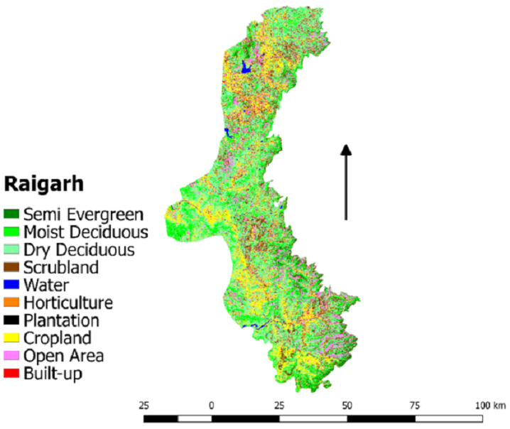
sq. km). Most of the moist deciduous forests can be seen in Pune
(17.03%), Thane (1259.02%), and Ratnagiri (36.91%) district
(Table 6). Total land use by semi-evergreen, moist deciduous and
dry deciduous is 739.8 sq. km, 8850.93 sq. km and 7500.18 sq.
km. Koyna WLS in Satara district, Radhanagari WLS in Ratnagiri,
and Chandoli NP between Sangli and Kolhapur districts contribute
a high proportion of the forest land areas in the region.
According to FSI Report (2017) on forest cover, Maharashtra
state has a geographical area of 307,713 Km
2 with a
forest cover
of 50,682 Km
2, out of which NWG of Maharashtra covers
an area of
57,690.4 Km
2 having a forest cover of 22,658.91
Km
2. Non-forest
categories include cropland, horticulture, plantation, built-up
and open area. Among non-forest categories, the highest
proportion is occupied by cropland which covers 20427.3 sq. km
of the land, followed by open area, which covers 10507 sq. km.
Built-up covers 1084.1 sq. km. Agriculture land is more in
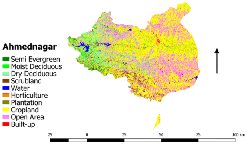
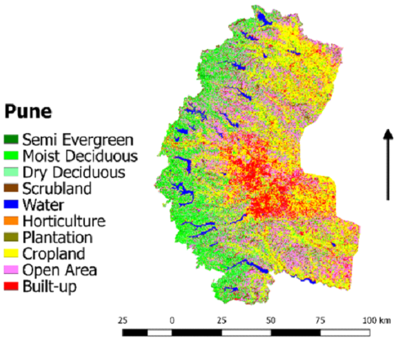
Nashik, Pune, and Satara districts of NWG of Maharashtra. In
contrast, open area is more in Pune (23.6%), Satara (14.74%) and
Ahmednagar (25.77%) and built-up land area are increasing in
Pune (4.37%) and Satara (2.19%) districts. Notably, plantation
land area is reported from the Sindhudurg district (30.2%). Due
to commercial and economic purposes of the teak plantation
(Tectona grandis) in NWG, high diversity areas are cleared,
affecting the habitat of flora and fauna species
(Kulkarni et
al., 2007) .
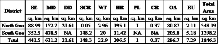
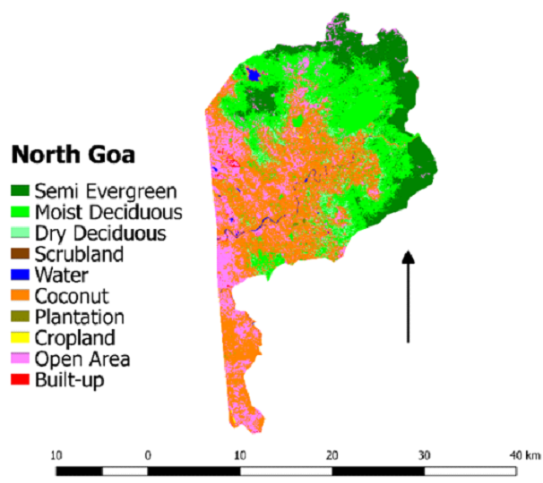
Table 7. Land use analysis of Goa part of NWG
| ⦁ NWG: Districts of Goa |
Statistics (sq. km) |
 |
Semi Evergreen: 88.99
Moist Deciduous: 152.7
Dry Deciduous: 21.61
Scrub Land: 0.05
|
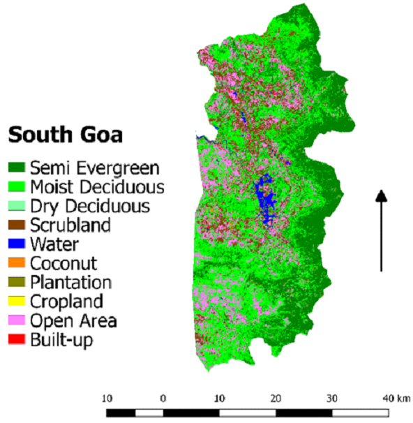 |
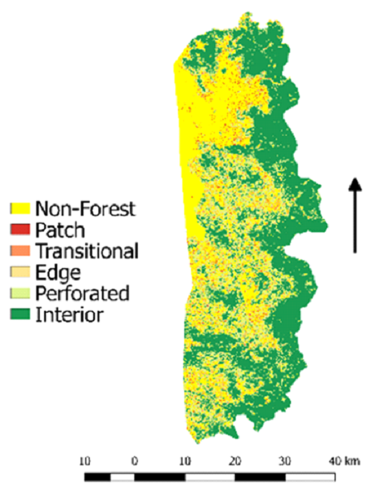
Semi Evergreen: 352.5
Moist Deciduous: 478.5
Scrub Land: 148.2
|
 |
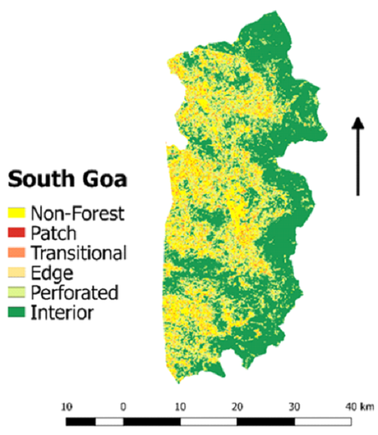
Semi-evergreen (352.5Km2) and moist
deciduous
(478.5Km2) more under South Goa district.
There is
acacia plantation in North Goa.
|
Table 7. Land use Statistics of Goa parts of NWG
(2018)
The land use pattern of the Goa parts of NWG has been
analyzed, where different land use categories have been
identified. The total land area has been divided into ten major
categories. Forest categories include semi-evergreen, moist
deciduous, dry deciduous, and scrubland. From table 6, it is
seen that in 2018 among forest categories, around 631.17 Km
2
area of Goa is occupied by moist deciduous forests, followed by
semi-evergreen and scrubland. The total geographical area of Goa
state is 196,244 Km
2 with a forest cover of 2,229
Km
2 (FSI
Report. 2017), whereas the NWG area of Goa is 1,846.34
Km
2 with
a forest cover of 1,242.58 Km
2. Non-forest categories
include
cropland, horticulture, plantation, built-up and open area.
Among non-forest categories, land use in NWG of Goa is most
occupied by coconut plantations. From table 7, it is seen that
286.7 sq. km in the Western Ghats region of Goa state is
occupied by open area (15.5), followed by horticulture which
occupies 206.5 sq. km and built-up by 7.29 sq. km. The South Goa
district of Goa shows maximum forest cover compared to North Goa
district. But, coconut plantation is more in North Goa. Open
areas in South Goa occupy land cover due to the increase in
mining activities. Most of the mining activities were reported
from Santona, Kodli, Sangod areas of South Goa. After analyzing
supervised classification results, it can be concluded that
dense forests areas of NWG of Goa are declining in recent years.
The overall accuracy of the classification ranges from 81.66 %
to 87.51%, and kappa value ranges from 0.77 to 0.80 (Table 8).
Table 8. Accuracy Assessment
| S.No. |
District |
Overall Accuracy |
Kappa Statistics |
| 1 |
Navsari |
81.66 |
0.77 |
| 2 |
Ahmednagar |
88.61 |
0.79 |
| 3 |
Pune |
86.34 |
0.79 |
| 4 |
Thane |
85.34 |
0.8 |
| 5 |
South Goa |
87.51 |
0.8 |
Monitoring and mapping the biological diversity of NWG, an
area of high biodiversity and under threat, is a challenge today
(Gadgil et al., 1998) .
Grazing, rainfall, slope, human
settlement, development activities, the introduction of invasive
and economic species, are the main reasons for creating
disturbances in the region. Forests and their resources are
important to fulfill the increasing need for food, water and
shelter worldwide. Forest degradation is the loss of forest
cover and the loss of many endemic, economic and medicinal
species that are part of forest areas. There is an urgent need
to assess land-use changes in NWG, and also, there should be an
understanding of how rapid urbanization is expanding and land
transformations are affecting and disturbing the ecological
balance. With the help of environmental programmes and policies
of indigenous people's participation in local forest department
programmes, attempts should be made to protect the remaining
ecologically important forest areas of NWG.
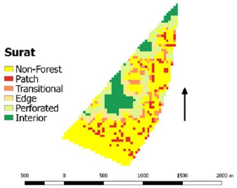
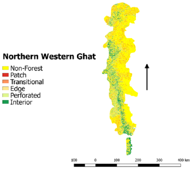
Forest Fragmentation
Table 9. Forest Fragmentation of NWG (2018)b>
| Northern Western Ghats |
Comments |
 |
Among all 3 states of NWG, interior forest area
(1063.71Km2) and patch area
(565.57Km2 )
|
| ⦁ NWG: Districts of Gujarat |
Statistics (sq.km) |
|
Patch: 0.09
Edge: 0.07
Interior: 0.15
|
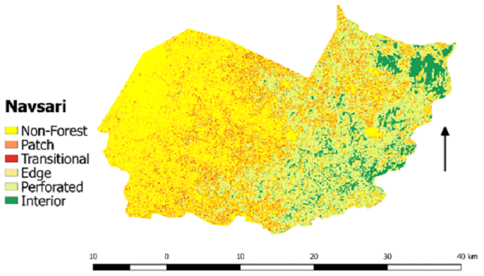 |
Patch: 34.26
Edge: 34.33
Interior: 34.95
|
 |
Patch: 69.81
Edge: 121.21
Interior: 288.2
|
 |
Patch: 137.69
Edge: 77.92
Interior: 107.93
|
 |
Patch: 0.09
Edge: 0.07
Interior: 0.15
|
 |
Gujarat has total 263. 85 Km2patch
forest, 264 Km2
edge forest and 538.6 Km2 interior
forest.
|
| ⦁ NWG: Districts of Maharashtra |
Statistics(sq.km) |
 |
Patch: 72.88
Edge: 36.49
Interior: 47.63
|
 |
Patch: 221.54
Edge: 181.71
Interior: 48.99
|
 |
Patch: 537.81
Edge: 207.8
Interior: 111.89
|
 |
Patch: 123.47
Edge: 303.62
Interior: 917.2
|
 |
Patch: 227.84
Edge: 26.35
Interior: 10.7
|
 |
Patch: 565.57
Edge: 260.61
Interior: 491.72
|
 |
Patch: 110.19
Edge: 259.12
Interior: 1012.87
|
 |
Patch: 120.18
Edge: 177.66
Interior: 541.46
|
 |
Patch: 272.97
Edge: 58.73
Interior: 415.07
|
 |
Patch: 118.46
Edge: 303.01
Interior: 698
|
 |
Patch: 15.24
Edge: 8.98
Interior: 106.4
|
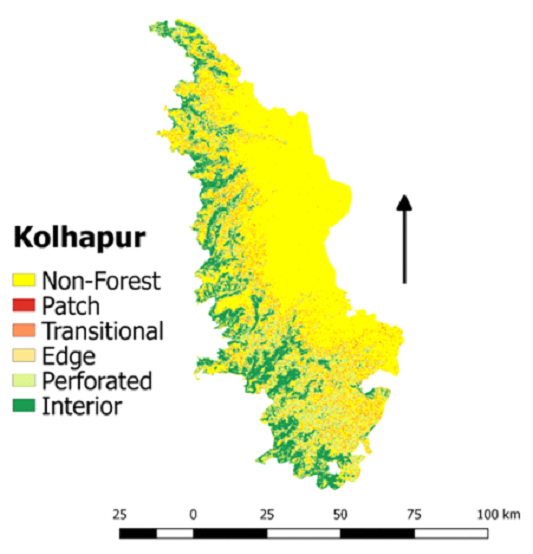 |
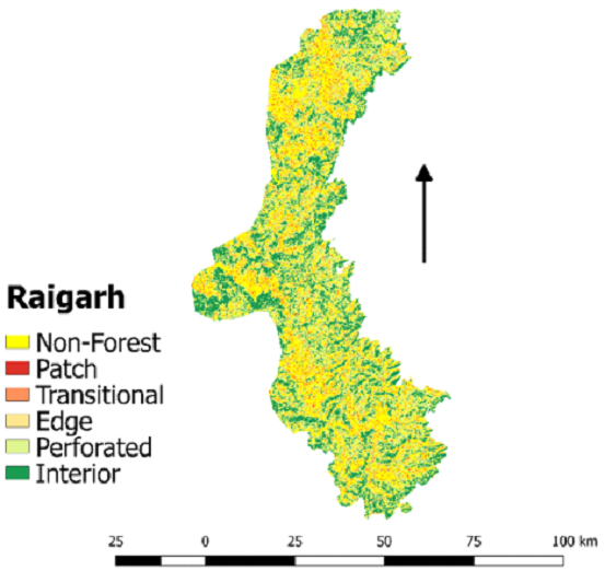
Patch: 150.82
Edge: 243.13
Interior: 1063.71
|
 |
Maharashtra has total 2536.97 Km2 patch
forest,
1927.05 Km2 edge forest and 5465.64
Km2 interior
forest.
|
| ⦁ NWG: Districts of Goa |
Statistics |
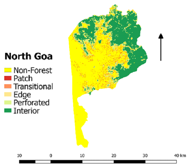 |
Patch: 11.22
Edge: 15.3
Interior: 158.33
|
 |
Patch: 15.52
Edge: 77.88
Interior: 626.85
|
 |
Goa has total 26.34 Km2 patch forest,
93.18 Km2 edge
forest and 785.18 Km2 interior forest.
|
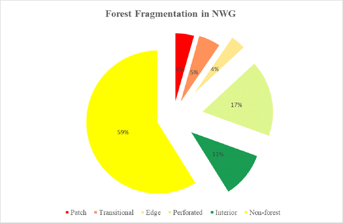
Fragmentation of forests at the landscape level was assessed
to understand spatial patterns in forest degradation using
land-use of 2018. Western Ghats area shows high fragmentation
due to an increase in cropland and developmental activities.
Forest areas constitute various herbs, shrubs, and tree species.
Figures 5 and Table 9 depict the pattern of the fragmentation
process in NWG and list the spatial extent of different types of
fragments (interior, perforated, edge, transitional, and patch
forests).
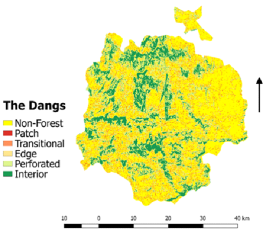
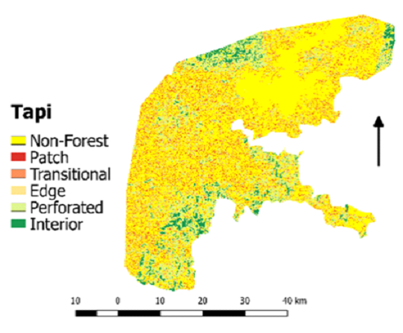
Forest fragmentation of Gujarat part of NWG depicts
domination of non-forest areas (47.93%) in the state. Interior
forests (9.67%) are located near the forest reserve, WLS, and
water bodies. Unplanned developmental activities such as
large-scale power projects and several irrigation projects have
led to the degradation of forests and formed barren hilltops
(Table 10).
Forest fragmentation of Maharashtra part of NWG depicts
domination of non-forest areas (60.43%). Perforated forests
(17.03%) are located near coastal areas of the district, whereas
interior forests are only 9.47%. Interior forests in NWG of
Maharashtra consist of dry deciduous, moist deciduous,
semi-evergreen, thorn forests, and swamp forests. The decline in
interior forests is due to industrialization, infrastructure
development, intensified agriculture, and plantations. Patch
forests (4.39%) are mainly located at the interfaces of forests,
intermixed with agriculture and urban classes over small
portions. Mining activities in the district leave significant
ecological, economic, and social footprints.
Goa part of NWG depicts domination of interior forests
(42.52%) due to dense evergreen and moist deciduous forests in
the region. Interior forests are located near Mahadei WLS. Edge
forests (5.04%) were basically reported from cropland areas.
Forest fragmentation in entire NWG depicts domination of
non-forests in the entire Western Ghats because most of the
forest in the region is dry, and leftover forests are degrading
due to forest fires and anthropogenic activities. Earlier, it
was reported that NWG had experienced a decline in forest cover
by 2%
(Ramachandra and
Bharath, 2020) .
Table 10 Forest fragmentation statistics of NWG
(2018)
| S.No. |
District Name |
Fragment Type
|
| Patch sq. km |
Transitional sq. km |
Edge sq. km |
Perforated sq. km |
Interior sq. km |
Non-forest area sq. km |
| 1 |
The Dangs |
69.81 |
98.51 |
121.21 |
284.59 |
288.2 |
901.05 |
| 2 |
Navsari |
34.26 |
34.33 |
16.04 |
129.44 |
34.95 |
239.94 |
| 3 |
Surat |
0.09 |
0.08 |
0.07 |
0.2 |
0.15 |
0.65 |
| 4 |
Tapi |
137.69 |
172.45 |
77.92 |
333.06 |
107.93 |
1300.65 |
| 5 |
Valsad |
22 |
50.49 |
48.76 |
263.87 |
107.37 |
227.08 |
| 6 |
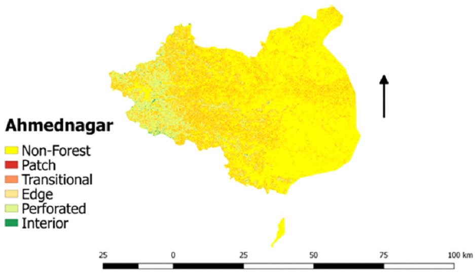
Ahmednagar |
227.84 |
163.26 |
26.35 |
307.69 |
10.7 |
2768.7 |
| 7 |
Dhule |
221.54 |
181.71 |
41.55 |
226.12 |
48.99 |
1787.75 |
| 8 |
Kolhapur |
150.82 |
234.8 |
243.13 |
887.7 |
1063.71 |
3710.47 |
| 9 |
Nandurbar |
72.88 |
69.89 |
36.49 |
139.44 |
47.63 |
608.53 |
| 10 |
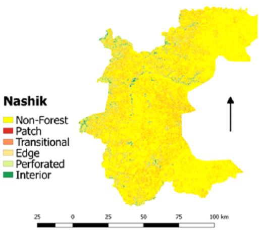
Nashik |
537.81 |
375.38 |
207.8 |
535.34 |
111.89 |
7566.64 |
| 11 |
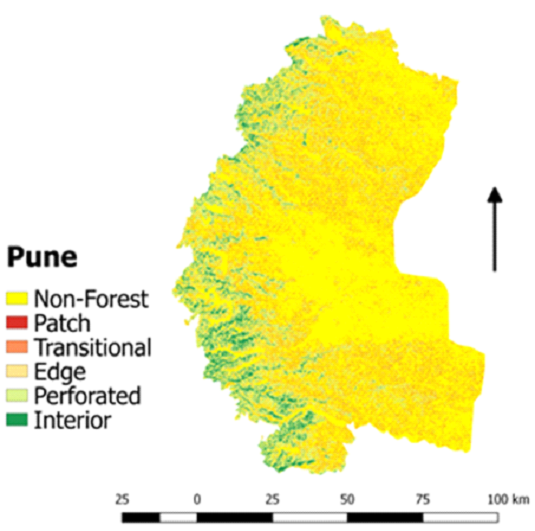
Pune |
565.57 |
549.57 |
260.61 |
1347.44 |
491.72 |
6808.21 |
| 12 |
Raigarh |
110.19 |
227.56 |
259.12 |
1263.62 |
1012.87 |
1289.33 |
| 13 |
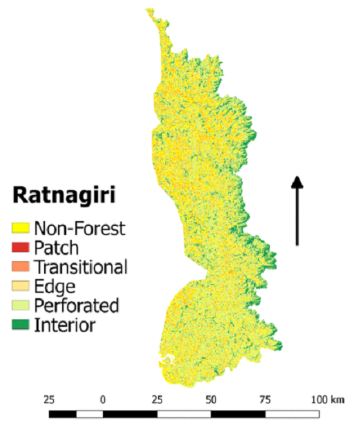
Ratnagiri |
118.46 |
393.2 |
303.01 |
2500.34 |
698 |
1765.64 |
| 14 |
Sangli |
15.24 |
12.78 |
8.98 |
51.02 |
106.4 |
378.43 |
| 15 |
Satara |
120.18 |
148.78 |
177.66 |
699.18 |
541.46 |
4501.92 |
| 16 |
Sindhudurg |
272.97 |
271.87 |
58.73 |
694.53 |
415.07 |
2031.06 |
| 17 |
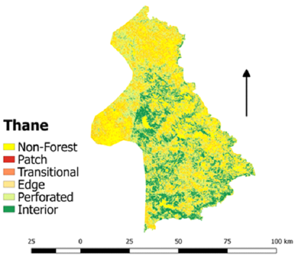
Thane |
123.47 |
251.62 |
303.62 |
1173.25 |
917.2 |
1648.97 |
| 18 |
North Goa |
11.22 |
10.6 |
15.3 |
47.92 |
158.33 |
0.25 |
| 19 |
South Goa |
15.52 |
46.29 |
77.88 |
286.9 |
626.85 |
244.67 |
Figure 5. Graph representing Forest Fragmentation in NWG
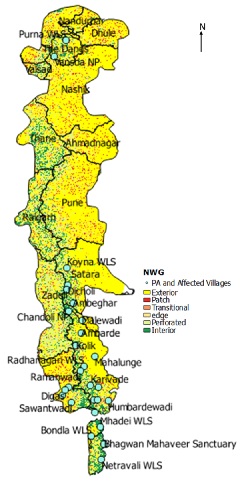
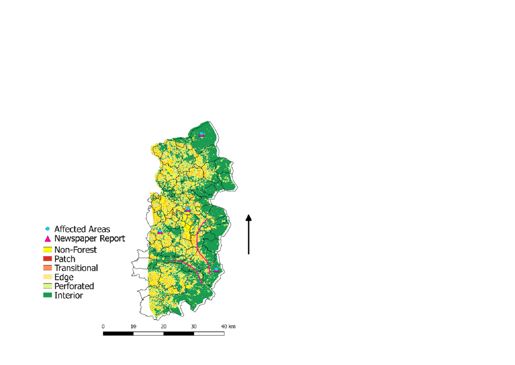
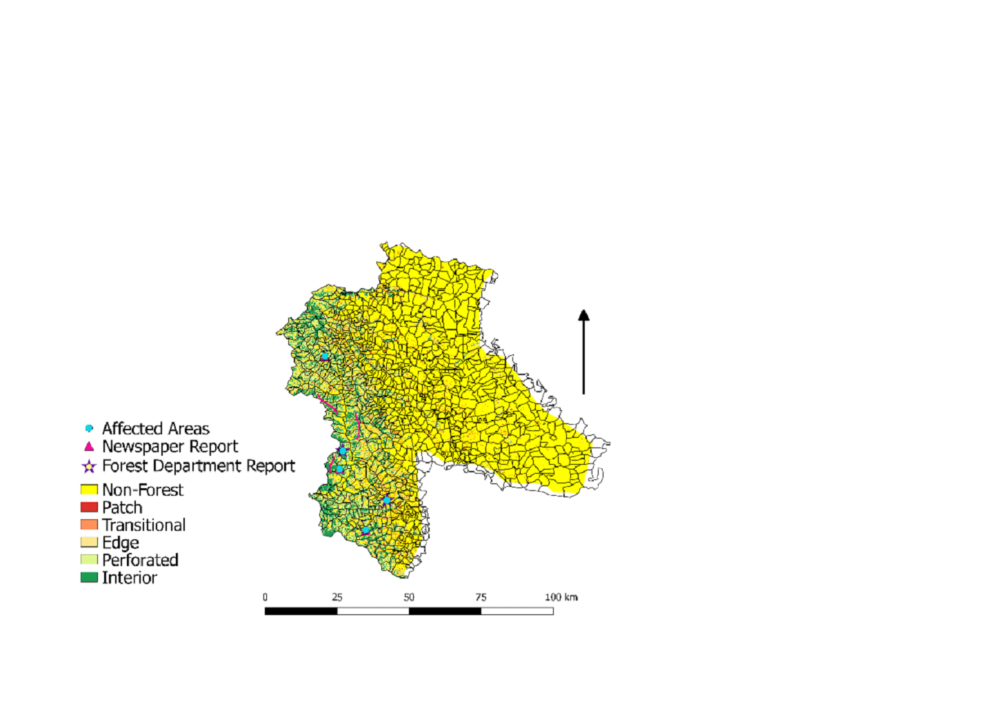
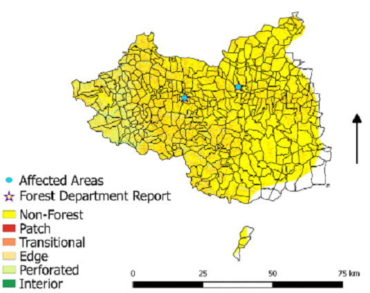
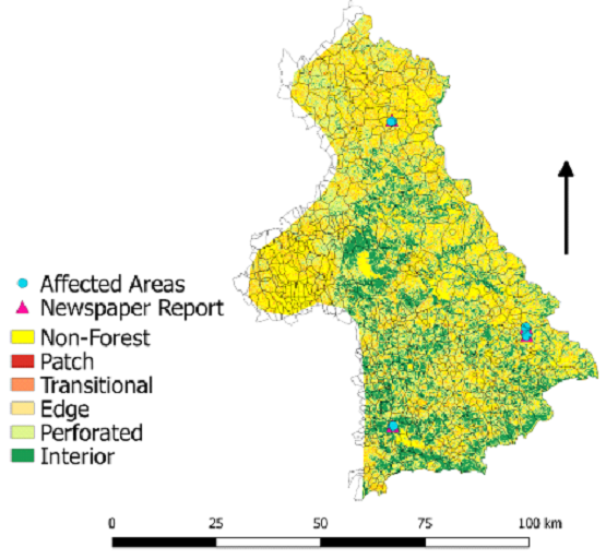
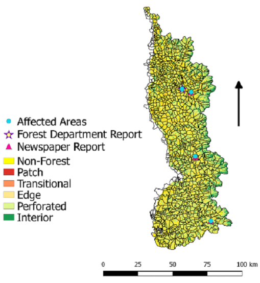
Human-Wildlife Conflict Analysis
Figure 5. Human-Wildlife affected areas in
NWG
Details of affected villages due to human-wildlife conflicts
were compiled from published papers, articles, and published
reports. The main reason behind the human-wildlife conflict is
the transformation of forest lands into croplands, and livestock
killing occurs when livestock is left alone for grazing. The
present study reviews the current situation of conflict between
humans and wildlife and assesses how it affects the livelihood
of indigenous people. Figure 5 shows human-wildlife conflict
patterns and villages affected by the same. It can be noted that
most of the villages affected by human-wildlife conflict are in
Satara, Ratnagiri, Sindhudurg, and Kolhapur districts of NWG.
Villages affected by elephants are Mura, Kirsule, Zadoli,
Ambeghar, Punavali, and Dicholi of Patan taluk of Satara
district. Livestock that is mainly depredated by elephant
attacks are cattle, livestock, buffalo, goat, and sheep. Koyna
Wildlife Sanctuary in Satara district comprises western tropical
and sub-tropical broadleaf hill forests and west coast
semi-evergreen forests; therefore, forest resources are high in
this region. Local people enter the protected area to collect
forest resources that initiate conflict with wild animals. The
Dapoli range of Ratnagiri district is affected by human-leopard
conflict. Kolhapur district is affected by human-elephant
conflict. Kolhapur forests are tropical semi-evergreen, moist
mixed deciduous, and dry deciduous. Villages in Kolhapur which
are affected by the conflict are Mahalunge (near Karnataka),
Hosur village of Chandgad tehsil, and villages of Ajra tehsil.
Elephant entry was also noticed from Maan village in Belgaum to
Mangoli village in Sindhudurg district. Sindhudurg forests are
composed of tropical semi-evergreen and moist deciduous.
Sawantwadi and Kudal range of Sindhudurg and Goa is affected by
the conflict between humans and elephants. Tillari dam near
Sindhudurg has dense forests and, therefore, there is a frequent
movement of elephants in this region from Karnataka. The
degraded forests are facing higher conflicts between human and
wild species. Due to the unavailability of food inside dried
forest areas, many wild species come out of protected areas
searching for food, attack the human population, and initiate
conflict with the indigenous people (Table 11).
Crop damage was reported by an elephant at Sindhudurg and
Kolhapur district. Paddy, wheat, rice are the main crops which
were damaged by the elephant. Radhanagari WLS in Kolhapur is
highly affected by the attack of Bos gaurus. Main wild mammal
species which are involved in crop depredation are elephant
(Elephas maximus), gaur (Bos gaurus), wild pig (Sus scrofa),
muntjac (Muntiacus muntjac), sambar (Rusa unicolor), hanuman
langur (Semnopithecus entellus), bonnet macaque (Macaca
radiate). many villages in NWG are affected by the attack of
sloth bear (Melursus ursinus), leopard (Panthera pardus),
elephant, tiger, and gaur.
Dense forests with natural resources dominate southern parts
of Kolhapur district, and elephant migrates from Karnataka
towards this region, for food, from November to June (Kulkarni
et al., 2008). Expansion of agriculture and human encroachment
inside forest areas initiated the elephant-human conflict in the
region. Kitavade, Ambarde, Bhogoli, Kolik, Mahalunge are the
village having dense population and forest areas and are
primarily affected by human-elephant conflict, so there is a
need to re-habitat these villages. Similarly, roads that are
inside dense forest areas need to be shifted (alternate route)
to allow easy movement of elephants without human interference.
The Forest department should take appropriate steps to manage
elephant migration into the southern parts of the Kolhapur
district.
The nutritive value of crops is also one of the prime
reasons for its extensive depredation by gaur species (Sukumar,
1990). Increasing agriculture losses are inflicted mainly by
gaur species because gaur does not have a hunting threat,
affecting the income of the households. Therefore, they have
preferred to work as daily wage laborers in towns and cities.
Radhanagari WLS has been experiencing a decrease in the forest
since 1985 due to increased anthropogenic activities and crop
cultivation. Therefore, due to livestock grazing, predator
population, and food resources are declining inside the WLS.
Gaur species is considered as a sacred cow, and hunting is
prohibited in the region (Atul, 2010).
The sloth bear (Melursus ursinus) is an omnivorous species,
but humans directly influence their wild activity by collecting
their food and damaging their habits by extracting timber and
firewood from the forest areas. Sloth bears caused the highest
number of injuries, mostly during winter.
Leopards (Panthera pardus) usually live in human-dominated
areas and attack livestock compared to other wild carnivores.
But it is observed from many humans dominated landscapes that
effective management approaches of forests and animal husbandry
programmes reduce human-animal conflicts (Rahalkar., 2008).
There is a conflict between humans and wildlife due to the
increasing needs of the human population and protecting Reserve
Forests and PA's is a challenge today (Maikhuri et al., 1997).
Protected areas, Parks, and Biosphere Reserves are vital as they
serve as sites for scientific research, natural repositories,
and several other functions. The present study has been done to
analyze the causal factors of human and wildlife conflicts in
the villages of NWG.
Loss of crops and livestock due to Human-wildlife conflicts
has posed conservation challenges worldwide. People tend to have
negative attitudes towards wild carnivore species due to the
increase in crop-raiding in the region. Therefore many farmers
have given up farming and moved to urban areas in search of
other income options
(Gillingham and Lee,1999) .
Kale et al.,
(2010) provided the possibility of connecting the corridors
covering existing protected areas. The research has highlighted
that connectivity can allow smooth assage of wildlife and reduce
the conflict and the money spent for the compensation. It has
shown protected areas such as Tungareshwar, Kalsubai, and Tansa
can be connected economically through the lowest cost corridors
of length 154 km and a mean width of 11 km on the northeast side
and 36.5 km in the east side. Other regions Bhimashankar,
Phansad, and Karmala remained isolated due to the absence of
forest cover and intense agricultural land use patterns.
Acquiring the land to establish forest cover might incur a
higher economic burden to the government. The Forest department
can compensate for loss either financially or by providing
alternate landscape areas. There should be proper grazing
practice, grazing close to villages, strengthened enclosures,
continuous guarding, and changing grazing practice (Donikar et
al., 2011).
Table 11: Human-Wildlife Corridor in NWG
| District |
Wildlife Corridor (Pink Color Depicts Wildlife
Corridor
|
Conflict Areas and Causes |
| South Goa |
 |
Affected areas are Surla, Verlem, Ugem and Rivona.
Areas facing attack of tiger and elephant. Conflict
occurred near patch and interior forests.
|
| Kolhapur |
 |
Hosur, Mahalunge, Ambarde, Kitavade, Bhogoli, Kolik
and Ajra are the areas of human-elephant conflict,
near patch and edge type. Elephant movement has been
reported from Karnataka forests
|
| Satara |
 |
Satara district is mainly affected by the attack of
elephants in Mura, Kirsule, Zadoli, Ambeghar,
Punavali, Dicholi, Taldeo, Patan, near interior and
patch fragments.
|
| Satara |
 |
There is no corridor in this region, but Sangamner
and Akola areas are affected by human-leopard
conflict. Affected areas are located near patch
forests.
|
| Kolhapur |
 |
There is no wildlife corridor. Masale, Pimpalgaon,
and Khed areas are facing human-leopard conflict.
Conflicts occurred near patch and perforated areas
of fragmentation.
|
| Pune |
 |
There is no wildlife corridor. Narayangaon, Otur,
Chakan, Rajgurunagar, Ghodegaon and Machar are the
areas affected by the attack of a leopard near patch
and perforated areas of sugarcane land.
|
| Ratnagiri |
 |
Dapoli range, Jogele, and Shirkenagar areas affected
by elephant attack near patch and perforated
fragment type. Elephant damages mango plantation of
the region.
|