Introduction
Human-animal conflict occurs when humans interfere inside the
protected habitats of wild animals and, animals move towards the
areas which are outside their natural habitat in search of food
(Lamarque et al., 2009) . Forest fragmentation will lead to the
formation of different size forest patches with diverse habitat
and ecosystem conditions. The movement of wild animals outside
the forest for food and encroachment by humans inside forest
areas initiates human-wildlife conflict. Human encroachment into
forest areas, allowing livestock grazing and collecting forest
resources for survival, leads to forest fragmentation and loss
to humans and animals. Increasing fragmentation leads to an
increasing level of human-wildlife conflicts
(Ramachandra et
al., 2018). Many wild animals are killed daily due to speedy
vehicles inside forest roads. Commonly killed species due to
road accidents are mouse deer, civet, dhole, wolf, and other
animals of forest areas. Many carnivore species are easily
attracted to small prey species such as goats, sheep, and
livestock grazing is also a reason for human-animal conflict.
Increasing human population near the periphery of forest areas
the transformation of protected land areas for the development
of agricultural lands, industries lands, hydroelectric projects
leads to fragmentation of wild animal habitats and reducing
sizes of forest patches. These transformed land areas are
uncomfortable for wild animals as their needs are not fulfilled.
In return, they attack the human population and result in
conflicts between humans and wild animals. The conflict between
humans and wild elephants is reported across various countries
among all wild animals. Elephants cause crop depredation and
raiding, and local villagers kill them in anger or self-defense.
It is reported that up to 20% of deaths of elephants in three
locations in India were caused by crop defense. In India,
human-wildlife conflict is mainly due to forest encroachment
inside forest areas for development purposes, an increase in
agricultural land, and disturbance in protected areas by
tourists
(Ramachandra and Bharath, 2019) . This conflict leads to
damage to crops and property of farmers and interferes in the
forest, wildlife, and livestock conservation. Asian elephants,
snow leopards, wild boars, and tigers are the main wild animals
involved in the human-animal conflict. The conflict between
humans and animals can be reduced by improving animal habitat so
that they minimize their movement towards human habitats in need
of food and water by initiating local training and awareness
programmes to address people about the conflict by creating
boundary walls around protected areas.
Wildlife Corridors
The increasing demand for land and natural resources has
threatened wildlife and wildlife habitats. This threat initiates
conflict between human and wildlife species. All forms of
anthropogenic activities and interactions with the natural
environment lead to change in the ecosystem, species
composition, and climate change and, therefore, ultimately
impact wild animals. Many environmental organizations and
policymakers have proposed wildlife corridors worldwide to
overcome these issues. A Wildlife corridor is a two-dimensional
landscape element that connects two or more wildlife habitat
patches that were previously connected but isolated due to
forest fragmentation and anthropogenic activities
(Gadgil et
al., 2011) . For connecting isolated habitat patches, wildlife
corridors are being used increasingly. Wildlife corridors allow
the movement of faunal species daily and seasonal and have
become a land use planning and management practice worldwide.
Due to the rapid industrial development and increasing
anthropogenic activities, natural forests are isolated and
fragmented around protected areas, in these cases, wildlife
corridors are made and used by various faunal species to
migrate, breed, and feed
(Srivastav and Tyagi, 2016) . The
function of the wildlife corridor is to enable the physical
movement of wildlife species which is decisive for their
long-term survival.
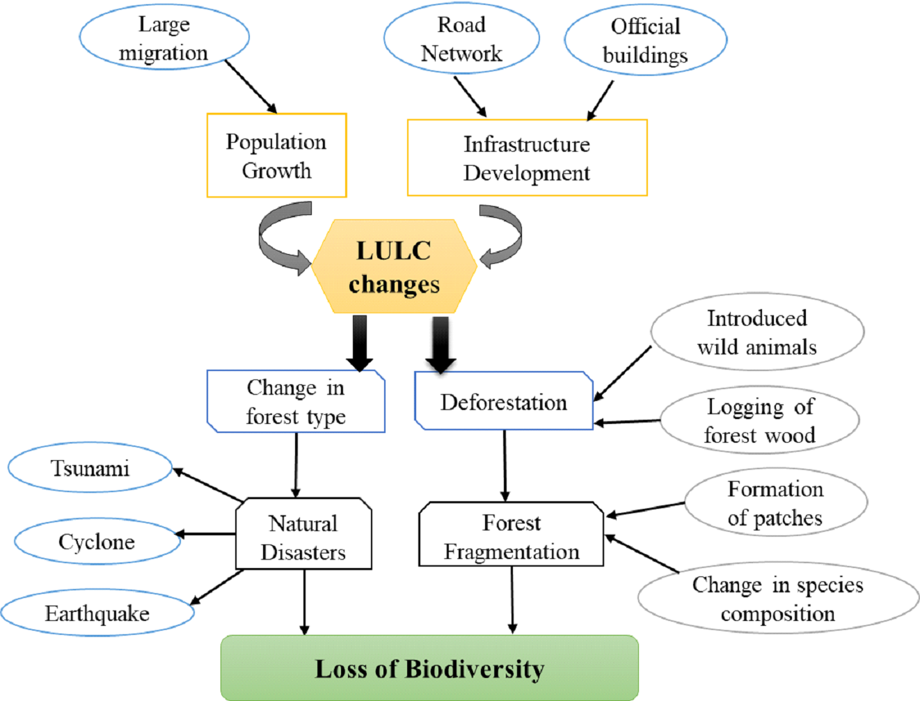
Forest Fragmentation and Land Use Changes
Land use refers to the way humans utilize land area, i.e.,
economic, development or management activities on land. In
contrast, land cover is natural surface, i.e., vegetation,
water, and other physical features. Land changes result in the
expansion of urban areas, which originates from undeveloped land
areas and, therefore, affects environmental and socio-economic
sustainability of the ecosystem (Figure 1), so there is a
constant need for multi-temporal remote sensing data in order to
check and monitor the expansions
(Yuan et al., 2005; Ramachandra
et al., 2017) . Fragmentation of natural forests and
deforestation are the primary reasons behind the worldwide loss
of biodiversity. Anthropogenic activities such as the conversion
of forest land, over-hunting, and logging are responsible for
forest cover loss, which is affecting the biodiversity,
microclimate, and hydrological regime
(Reddy et al., 2014;
Ramachandra et al., 2020) . For sustainable development and
utilization of forest resources, forest extent assessment is
done worldwide to conserve forests and know the extent of their
degradation.
Roy et al., 2013, reported that types of forest
fragmentation and estimated that about 67.28% are intact forest
and 1.64% are fragmented, whereas Dry (18.72%) and moist
deciduous forests (16.22%) constitutes most of the area of
intact forests and are highly protected with low fragmentation
activities. It was reported that intact forests have 6660
species (3962 herbs sp., 1882 shrubs sp., 2072 trees sp.),
whereas highly fragmented forest areas constitute 1125 total
species (490 herb sp., 259 shrub sp., 444 tree sp.). Intact
forests are highly conserved and less fragmented, and are
endowed with a large number of endemic, medicinal, and
economically important plant species.
Reddy et al., (2014) had carried out a study in the Eastern
Ghats and reported that dry deciduous forests are the dominating
forest types of Eastern Ghats with an area of 37192 Km
2 (52.2%).
They also reported that about 9.2% of semi-evergreen forests,
which are found in the Eastern Ghats part of Andhra Pradesh and
Odisha, whereas Andhra Pradesh has 17044 Km
2 area under dry
deciduous forests. It was suggested that forest fragmentation,
rapid urbanization, agriculture, collection of natural forest
products, and other anthropogenic activities damage the
remaining forest diversity of Eastern Ghats and harm many
migratory bird species and other faunal species.
Figure 1. Impacts of LULC changes
Human-Wildlife Conflicts
Wild animals and humans have coexisted and shared the same
natural resources. However, mismanagement of ecosystems leads to
deprivation of food, fodder and water to the dependent biota,
leading to human-animal conflicts
(Kulkarni et al., 2008; Manral
et al., 2016) . Conflicts between humans and wildlife resulted
from the growing fragmentation of forests and degradation of
wildlife habitats.
Ratnagiri district of Maharashtra (15֯ 36’-18֯ 05' N; 73֯
05’-74֯ 36' E) with a spatial extent of 8,200 sq. km and located
in the eastern part of Northern Western Ghats (NWG). The
district has a dominant population of carnivore species such as
leopards, and herbivores - Spotted Deer, Wild Boar, and goat,
buffalo, and cattle. Most leopard attacks happened during the
daytime (60%)
(Athreya et al., 2004) , in the forest area (71%).
After collecting human-leopard conflict information from 284
respondents of the study region during 2009 and 2010, it was
analyzed that many people experienced livestock loss. It was
important to note that almost 56% of respondents wanted leopards
around even though they suffered livestock loss, this was
because these respondents were getting compensation from the
forest department for the loss of livestock
(Doniker et al.,
2011).
Human and wildlife conflict is a challenging phenomenon
worldwide where humans are affected economically. In India,
human-wildlife conflict mainly resulted from carnivores such as
hyenas, wolves, jaguar wolves, snow leopard, leopard, tiger, and
lion species, and needs conservation throughout their range
(Sekhar et al., 1998)
Radhanagari WLS, with semi-evergreen forests having an area
of 351.16 sq. km, is situated in NWG of Maharashtra, and around
55 villages are situated in and around it. In order to analyze
human-wildlife conflict over 30 years, i.e., crop and livestock
depredation, human attacks by wildlife animals, a questionnaire
survey was conducted in 189 households in 172 villages of 49
forest ranges in Goa and Maharashtra and monitored for 17 months
during the survey period. It was recorded that 253 households
were dependent on agriculture and livestock for their
livelihood, so around 85% can only cultivate during the monsoon
season due to water scarcity in the region
(Joshi and
Madhusudan, 2010) .
Livestock depredation was analyzed between the years 1971 to
1996 in Kibber village, which is bordering the Kibber Wildlife
Sanctuary of Himachal Pradesh. After interviewing 80 households
from three study villages, every household owned goat/sheep
(95%) and at least one cow (89%). Villagers reported 18% (total
of 189) livestock deaths due to wild predators, which accounted
for 42.1% economic loss of the village families. Except for cows
and dzomo, all livestock species, especially horses (37.4%),
were killed significantly with a high frequency proportional to
their abundance. The livestock and crop depredation by wild
carnivores have increased during the last five years in the
vicinity of Kibber Wildlife Sanctuary
(Mishra, 1997) .
Madhya Pradesh state has the largest sloth bear population
in India in an area of 135,395 sq. km. There has been an
increase in population and pressure on the landscape; therefore
a study has been conducted from the year 1989 to 1994 to examine
human-sloth bear conflict and areas where sloth bear-human
interactions occur by documenting the desired information
obtained from indigenous people. It was observed that tropical
dry and wet deciduous forests are the most suitable habitat for
them. About 67.2.5 human-sloth bear incidents were recorded in
which 6.5% individuals were killed during encounters, whereas
43% encounters were reported from 12 nearby villages. Humans
encroaching sloth bear habitat led to 70.9% of human causalities
in Raigarh, Sarguja North, Bilaspur North, Korea, and Raipur
North. During five years, 687 serious damages have been reported
from 13 PA's and 17 forest divisions of MP, wherein Bilaspur
North forest division highest encounters occurred (65.4%) in
crop fields outside the forest range
(Rajpurohit and Krausman et
al., 2000) . Similarly, in Yellowstone NP, USA, 1,27 human
injuries from black bears and 75 from grizzlies were reported
between 1930 and 1978
(McCullough, 1982) .
Habitat suitability for Elephant (Elephas maximus) is
analyzed in the Southern part of Kolhapur district, which lies
between 16° 20' N to 15° 55' N and 74° 0' E to 74° 30' E of
Sahyadri range, by conducting fieldwork which includes
interviews with farmers. The site suitability map for the
elephant was generated by analyzing Remote Sensing data of 2005,
which aided in developing strategies to reduce human-elephant
conflict, protect elephants and humans, and minimize economic
loss of the region. In 2004, two elephants came from Karnataka
to the Kolhapur district, and elephant migration continued till
2012. Human injuries crop damage (2638 cases), were the
incidents that happened due to elephant migration
(Mehta, and
Kulkarni, 2013) .
Habitat suitability for one-horned rhinos in Kaziranga NP
was assessed
(Kushwaha and Roy 2000) during 1967 -1998. It was
estimated that tall grasses occupied a significant part of the
park (61%). A reduction in the area by 23.6% was observed in
1990, whereas the wetland (locally called as Beel) area showed a
decrease by 1997, i.e., around 27.4%. A corridor linkage between
Kaziranga NP and Karbi Anglong Hills needs to be developed. The
area surrounding the park should be merged with it to expand its
territory and protect the species in the near forests.
Three corridors, namely; Motichur-Chilla, Kotdwar and
Ramnagar of Rajaji-Corbett Elephant Reserve, having area 821 sq.
km lies between 77֯ 00' and 79֯ 15 E and 29֯ 00' and 30֯ 30' N,
were investigated during 1967, 1986, and 1998
(Hanna et al.
2001) . The study highlights that forest area of elephant habitat
was reduced due to the formation of the reservoir area. Narrow
corridors in the region are hindering elephant movements.
Subsequent investigation
(Johnsingh and Williams 1999) confirm
the earlier findings of human interference, over-grazing, and
lack of tree regeneration in the Motichur-Chilla corridor.
Study of crop damage and livestock depredation in the buffer
zone (1612.12 sq. km) of Nanda Devi Biosphere Reserve (NDBR) and
reported
(Rao et al., 2000) that wheat/barley and potato were
highly damaged crops in lower elevation villages (Lata, Peng,
and Tolma village). Apple, walnut, and apricot fruit crops are
mostly damaged by the attack of wild carnivore species, such as
wild boar, monkey, musk deer, etc. They also studied the wild
animal activity and reported that monkeys and wild boar caused
56-60% of total crop damage, whereas leopards and bears killed
around 875 livestock in NDBR. Many households in the villages
are dependent on agriculture for their income, and any form of
crop damage (trampling and mortality) affects the economic
conditions of the village families
(Rao et al., 2000) .
Asian Elephant (Elephas maximus) population in Maharashtra
districts has been reported in recent years, but earlier, it was
reported from Dhule and Nandurbar districts of Maharashtra
(Chitampalli, 1983) . There were three elephant groups reported
in Maharashtra in 2013, in Chandgad range, Kudal range and
Tilari Reservoir. From 2002 onwards, the elephant movement in
Maharashtra districts was initiated from the forest ranges of
Karnataka state.
Mehtha and Kulkarni (2013) studied the elephant
movement in Maharashtra's Sindhudurg and Kolhapur districts.
They reported that elephants' crop depredation and human
injuries were more in Sindhudurg than Kolhapur. They also
reported that from 2002 to 2013, Maharashtra faced 10,200 crop
damage cases by elephants and Rs. 90,248 were paid to farmers as
crop depredation compensation by the forest department.
The current issue of Sahyadri E-News focuses on
⦁ district-wise assessment of land uses through the
classification of remote sensing data of 2018 in the Northern
Western Ghats.
⦁ Assessment of forest fragmentation.
⦁ Evaluation of locations of human-animal conflict in the
Northern Western Ghats through data mining.
⦁ Understanding linkages of forest fragmentation and
human-animal conflicts in the Northern Western Ghats.