|
CARRYING CAPACITY BASED CONSERVATION AND SUSTAINABLE MANAGEMENT OF RIVERINE ECOSYSTEMS
(PDF)
T V Ramachandra
Energy and Wetlands Research Group,
Centre for Ecological Sciences,
Indian Institute of Science - 560012
4. Results & Discussion
4.1. Land use analysis
The forests of Netravathi river basin with the repository of rich biodiversity have been supporting the livelihood of people in the districts of Central Western Ghats. The land use analysis of Netravathi river basin depicts the status of forest cover during the year 2016 (Figure 3 and Table 2). The area under forest cover shows 51.67 % after losing significant patch of forests for mini-hydroelectric, infrastructure projects and monoculture plantations [4]. The plantations constitute 26.42 % of the basin and major forests are confined to the eastern side of the basin (Figure 3).
 Figure 3: Land use analysis of Netravathi river basin
| DESCRIPTION |
Ha |
% |
| Evergreen forests, deciduous forest, degraded forests, etc. |
224900 |
51.67 |
| Horticulture and Forest plantations |
115010 |
26.42 |
| Current Sown and Fallow Agricultural lands |
21800 |
5.01 |
| Buildings, Roads and paved surfaces |
9410 |
2.16 |
| Open area, Grasslands, Riverbed, Sand, Quarries, Cloud and Shadow |
61030 |
14.02 |
| Rivers, Lakes, Ponds, Estuary |
3150 |
0.72 |
| TOTAL AREA |
435300 |
Table 2: Land uses in Netravathi basin.
Figures 4 depicts the flora categorised as per IUCN status, compiled from field and also published literatures. The significant floral species includes Knema attenuate, Gymnacranthera canarica, Holigarna ferruginea, Myristica malabarica, Ochreinauclea missionis, Madhuca insignis, Memecylon angustifolium, Syzygium travancoricum, Pandanus unipappilatus, Helminthostachys zeylanicus Diplazium esculentum, Strobilanthes ciliates, Hopea ponga, Vateria indica, Euonymus indica, Carallia brachiata, Madhuca neeriifolia, Calophyllum apetalum, Elaeocarpus tuberculatus, Vitex leucoxylon Kingiodendron pinnatum etc., and many of them are under Critically Endangered, Vulnerable, Threatened categories. The region is home to endangered Myristica swamps having Critically Endangered Syzigium travancoricum and Gymnacranthera canarica (Vulnerable) are amongst many other species [4]. The swamp ecosystem is under higher threat due to horticulture expansion and land conversion for other developmental activities. The area has a large number of medicinal plants and non-timber forest product (NTFP) yielding plants. The distribution of 429 flora species in 95 families is given in Figure 4. The region is home to many very rare, endemic and endangered wildlife (Figure 5) covering 418 species under 126 families. Main predators are tiger (Panthera tigris), leopard, wild dog (dhole) and sloth bear. Leopards are in good number and wild dogs are in very less number, usually sighted in KNP region and Gundia basin.
 Figure 4: Flora diversity of Netravathi as per IUCN status
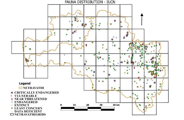 Figure 5: Faunal diversity of Netravathi as per IUCN status
Elephant Reserve (total area of 6,724 sq.km, vide GO FEE 231 FWL 2000, 25/11/2002), which forms a link connecting Western Ghats and Eastern Ghats covering many wildlife sanctuaries, national parks etc. [4]. Bisle forest adjoins Kempholé Reserve Forest in north and Pushpagiri Wildlife Sanctuary in the south. It is an integral and important part of the Mudumalai-Nagarhollé-Brahmagiri-Muttodi Corridor (Figure 6).
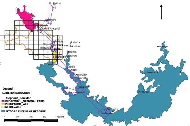 Figure 6: Elephant movement path (Mutthodi to Bannerghatta)
Theme wise grid based spatial layers (land use, flora, fauna, protected area, geo-climatic (altitude, slope, rainfall, etc.), litology, porosity, soil type, soil depth, drainage network, perenniality of streams, annual runoff, social aspects, population density, estuarine diversity and productivity) with the relative weights were overlaid, which aided in prioritising the ecologically sensitive regions (ESR) based on the cumulative scores (grids with the spatial themes). These grids with the cumulative weights (scores) were grouped into four categories. Figure 7 shows prioritised grids: 28 grids represent ESR 1, 12 grids represent ESR 2, 14 grids represent ESR 3 and the rest 20 grids represent ESR 4. The 38% of the area of grids represents ESR 1, 16% of the area shows ESR 2, 19 % of the area shows ESR 3 and only 27 % area covers ESR 4 (Table 3). ESR 1 represents zone of highest conservation, no further degradation allowed. ESR 1 can be treated as a highly sensitive region and more conservation is to be imposed by regulatory authorities as well as VFCs (Village forest committees). ESR 2 represents a zone of higher conservation and forms a transition for highest conservation and moderate conservation regions. ESR 3 represents moderate conservation region and only regulated development is allowed in these areas. ESR 4 represents least diversity areas and the developments are allowed as per the requirement by strict vigilance from regulatory authorities. It is recommended that these regions are also has a lot of scope for further enrichment of environment by stakeholders and forest department intervention. In ESR 2 & ESR 3 further developments are allowed only after critical review of regulatory and extensive consultations with stakeholders.
 Figure 7: Ecologically Sensitive Regions of Netravathi river basin
| DISTRICT |
ESR-1 |
ESR-2 |
ESR-3 |
ESR-4 |
TOTAL |
| D K |
62 |
31 |
95 |
119 |
307 |
| Udupi |
1 |
6 |
0 |
15 |
22 |
| Chikmagaluru |
9 |
7 |
0 |
0 |
16 |
| Hassan |
33 |
21 |
24 |
0 |
78 |
| Kodagu |
6 |
4 |
0 |
0 |
10 |
| RIVERBASIN |
111 |
69 |
119 |
134 |
433 |
Table 3: ESR Villages under various districts of Kali river basin.
Figure 8 shows ecologically very sensitive regions such as Gundya, Pushpagiri WLS, Kudremukh NP, Yettinahole regions. These areas are majorly covered in ESR-1 & 2 which signifies the necessity of protecting these regions from further degradations. The village wise ESR delineation is given in Figure 9. The ESR-1 shows 111 villages, ESR-2 shows 69 villages, ESR-3, 4 shows 119 and 134 villages respectively. The Dakshina Kannada district has 307 villages out of which 62 villages depict ESR-1. Forests of these villages need to be protected on priority. The prohibited and regulated activities in each ESR region are listed in Table 4.
 Figure 8: Ecologically Significant areas of Netravathi river basin
NEXT
Figure 8: Ecologically Significant areas of Netravathi river basin
NEXT
|