| Sahyadri Conservation Series: 24 |
ENVIS Technical Report: 54, April 2013 |
 |
Kumaradhara River Basin, Karnataka Western Ghats: Need for Conservation and Sustainable Use |
 |
1Energy and Wetlands Research Group, Centre for Ecological Sciences, Indian Institute of Science, Bangalore – 560012, India.
2Member, Western Ghats Task Force, Government of Karnataka, 3Member, Karnataka Biodiversity Board, Government of Karnataka
4Member, Tree Authority Mangalore (Rural), Government of Karnataka
*Corresponding author: cestvr@ces.iisc.ac.in
|
SUBMERGENCE AREA
Water spread area was assessed by digitizing the contour of 83 m. Contours of 80 and 100 m were digitized using the Survey of India topographic maps of Scale 1:50000. Interpolation of these provided 83 m contour and overlay of Figure 5 with the region corresponding to 83 m contour provided the extent of submergence, which is about 1882.96 hectares. Table 3 lists various land uses in the submergence area. Forest constitute the major portion (46.66%) followed by areca plantation (27.75%), rubber plantation (6.53%) and agriculture (1.87%).
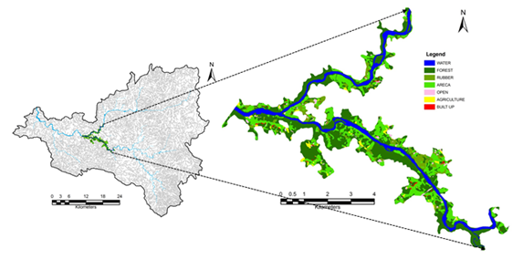
Figure7: Kukke MHS Submergence area 83 m RL
Table 3: Land uses in the likely submergence area (at FRL 83 m)
| Land Use |
Area in Ha |
Percentage |
| Water |
276.25 |
14.67 |
| Forest |
878.59 |
46.66 |
| Rubber |
122.99 |
6.53 |
| Areca |
522.44 |
27.75 |
| Open |
33.41 |
1.77 |
| Agriculture |
35.18 |
1.87 |
| Built up |
14.10 |
0.75 |
| Area under Submergence |
1882.96 |
|
|
|
T.V. Ramachandra
Centre for Sustainable Technologies,
Centre for infrastructure, Sustainable Transportation and Urban Planning (CiSTUP),
Energy & Wetlands Research Group, Centre for Ecological Sciences, Indian Institute of Science, Bangalore – 560 012, INDIA.
E-mail : cestvr@ces.iisc.ac.in
Tel: 91-080-22933099/23600985,
Fax: 91-080-23601428/23600085
Web: http://ces.iisc.ac.in/energy
Subash Chandran M.DEnergy & Wetlands Research Group, Centre for Ecological Sciences, Indian Institute of Science, Bangalore – 560 012, INDIA.
E-mail:
mds@ces.iisc.ac.in
H. Surya Prakash Shenoy
Member, Tree Authority Mangalore (Rural), Government of Karnataka
G.R. Rao
Energy & Wetlands Research Group, Centre for Ecological Sciences, Indian Institute of Science, Bangalore – 560 012, INDIA.
E-mail:
grrao@ces.iisc.ac.in
S. Vinay
Energy & Wetlands Research Group, Centre for Ecological Sciences, Indian Institute of Science, Bangalore – 560 012, INDIA.
E-mail:
vinay@ces.iisc.ac.in
Vishnu Mukri
Energy & Wetlands Research Group, Centre for Ecological Sciences, Indian Institute of Science, Bangalore – 560 012, INDIA.
Sreekanth Naik
Energy & Wetlands Research Group, Centre for Ecological Sciences, Indian Institute of Science, Bangalore – 560 012, INDIA.
Citation: Ramachandra T.V, Subash Chandran M.D, Surya Prakash Shenoy H, Rao G.R., Vinay S, Vishnu Mukri and Sreekanth Naik, 2012. Kumaradhara River Basin, Karnataka Western Ghats: Need for Conservation and Sustainable Use., Sahyadri Conservation Series 24, ENVIS Technical Report : 54, April 2013, Energy & Wetlands Research Group, Centre for Ecological Sciences, Indian Institute of Science, Bangalore 560 012.
| Contact Address : |
| |
Dr. T.V. Ramachandra
Energy & Wetlands Research Group,
Centre for Ecological Sciences,
New Biological Sciences Building, 3rd Floor, E-Wing, Lab: TE15
Indian Institute of Science, Bangalore – 560 012, INDIA.
Tel : 91-80-22933099 / 22933503(Ext:107) / 23600985
Fax : 91-80-23601428 / 23600085 / 23600683 [CES-TVR]
E-mail : cestvr@ces.iisc.ac.in, energy@ces.iisc.ac.in,
Web : http://wgbis.ces.iisc.ac.in/energy |