| Sahyadri Conservation Series: 24 |
ENVIS Technical Report: 54, April 2013 |
 |
Kumaradhara River Basin, Karnataka Western Ghats: Need for Conservation and Sustainable Use |
 |
1Energy and Wetlands Research Group, Centre for Ecological Sciences, Indian Institute of Science, Bangalore – 560012, India.
2Member, Western Ghats Task Force, Government of Karnataka, 3Member, Karnataka Biodiversity Board, Government of Karnataka
4Member, Tree Authority Mangalore (Rural), Government of Karnataka
*Corresponding author: cestvr@ces.iisc.ac.in
|
INTERVENTION IN THE RIVER BASIN: KUKKE MINI HYDEL SCHEME (KUKKE MHS)
A 24 MW hydel power unit (Kukke MHS) is proposed across Kumaradhara near at Kunturu Perabe village Ullipu, Puttur Taluk of Dakshina Kannda district (Figure 6.1). Kumaradhara originates at an elevation of 1480m AMSL and drops down to about 74 m at the dam site. The river travels about 64 km in its course from Madekeri to the dam site. Figure 4 indicats the proposed dam site on the toposheet (48 P/6). The catchment area is about 1412 sq.km, the rainfall (Figure 6.2) varies from 3100mm to more than 4250 mm resulting in an annual yeild of 5600 Mcum.
The proposed barrage / dam across the river is located at 750m downstream of the confluence of Kumaradhara and Gundia River near Koodige Ullippu of Kuttruppady village. The valley is narrow and the abutment has a slope of 1:1 at proposed site. The width of the river bed is about 250 m and the bed level is 64m. The river bed at the proposed site is rocky at places and bedrock is exposed along the upstream and downstream of the barrage. As the project site falls under Precambrian peninsular gneissic terrain, the rocks present are Granite Gneiss and pegmatite bands intruded by basic dykes.
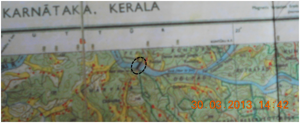
Figure6.1: Topographic map indicating the location of MHS site
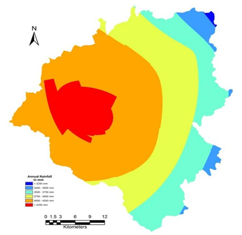
Figure 6.2: Average Annual Rainfall (1901 – 2010) at dam site
The Mini Hydel Scheme (MHS) envisages construction of a power house with an installed capacity of 24 MW. The main components of Kukke MHS as planned are: i) barrage/dam across the River with radial and stoplog gates, ii) coarse trash rack structure adjacent to barrage right side, iii) intake structure on downstream of coarse trash rack structure, iv) powerhouse of 8 generating units of 3 MW each with service bay, control room, etc., v) tailrace pool and open tail race channel including the regarding of riverbed on down streams, and vi) outdoor yard (ODR) of 67m X 94m. Table 1 lists the salient features of the project.
Table 1: Salient features of Kukke Stage 1 MHS
| 1 |
|
Location |
|
|
| |
1 |
State |
: |
Karnataka |
| |
2 |
District |
: |
Dakshina Kannada |
| |
3 |
Taluk |
: |
Puttur |
| |
4 |
River |
: |
Kumaradhara |
| |
5 |
Tributary to |
: |
Netravathi |
| |
6 |
Latitude |
|
|
| |
i |
Diversion Barrage |
: |
12° 44' 41"N |
| |
ii |
Power House |
: |
12° 44' 43" N |
| |
7 |
Longitude |
|
|
| |
i |
Diversion Barrage |
: |
75° 23' 59" E |
| |
ii |
Power House |
: |
75° 23' 46" E |
| |
8 |
Nearest Village |
: |
Dolpadi and Kaniyuru (left side) |
| |
9 |
Nearest Town |
: |
Puttur (25km) |
| |
10 |
Nearest City |
: |
Mangalore (65km) |
| |
11 |
Nearest Airport |
: |
Mangalore |
| 2 |
|
Purpose of Project |
: |
Generation and Transmission of Hydroelectric power |
| 3 |
|
Installed Capacity |
: |
8 X 3.0 MW |
| 4 |
|
Annual energy Generation |
: |
73.32 GWHr |
| 5 |
|
Hydrology |
|
|
| |
1 |
Catchment Area |
: |
1450 sq.km |
| |
2 |
Average Annual Yield |
: |
5610Mcum |
| |
3 |
Design power Discharge |
: |
58.92 cumecs/Unit, at rated head |
| |
4 |
Maximum power discharge |
: |
73.65 cumecs/Unit |
| |
5 |
Design flood (at Diversion Barrage site) |
: |
5200 cusecs |
| |
6 |
Air Temperature |
|
|
| |
|
Maximum |
: |
42° C |
| |
|
Minimum |
: |
11.5° C |
| |
7 |
Humidity |
|
|
| |
|
Maximum |
: |
100% |
| |
|
Minimum |
: |
32% |
| 6 |
|
Diversion Barrage |
|
|
| |
1 |
Location |
: |
Diversion Barriage across Kumaradhara river, near Kunturu perabe village,
20 km from Puttur Taluk, Daksina Kannada District |
| |
2 |
Type |
: |
Gated, Gravity section built out of mass concrete |
| |
3 |
FRL |
: |
El 74.00m |
| |
4 |
MWL |
: |
El 74.00m |
| |
5 |
Top of Bridge/ Non Overflow section |
: |
El 75.50m |
| |
6 |
Diversion Barriage crest |
: |
El 64.40m |
| |
7 |
Deep Foundation level |
: |
El 62.425m |
| |
8 |
Height of the Diersion Barriage upto crest ( from the deepest foundation level) |
: |
1.975 m |
| |
9 |
Length of overflow section |
: |
155.00m |
| |
10 |
Length of non-overflow section, left bank |
: |
23.730m |
| |
11 |
Coarst trash rack cum right NOF block |
: |
142.75m |
| |
|
Total |
: |
321.48m |
| |
12 |
Flood Discharge capacity of diversion Barrage |
: |
5200 cumecs |
| |
13 |
Flood lift from FRL |
: |
0.00 m |
| |
14 |
Gates |
|
|
| |
|
a) Radial Gate |
|
|
| |
|
i) Nos |
: |
10 |
| |
|
ii) Size |
: |
12.00m X 9.6 m |
| |
|
iii) Type |
: |
Radial gate |
| |
|
iv) Hoist |
: |
Rope Drum |
| |
|
b) Stop log Gate |
|
|
| |
|
i) Sets |
: |
1 Set |
| |
|
ii) Size |
: |
12.00 m X 9.6 m |
| |
|
iii) Type |
: |
Vertival lift roller gate |
| |
|
iv) Hoist |
: |
Gantry Crane |
| 7 |
|
Intake |
|
|
| |
1 |
No of Vents |
: |
16 |
| |
2 |
Vent Size |
: |
4.40 m X 5.35 m |
| |
3 |
Sill Level |
: |
El 62.08m |
| |
4 |
Hoist Bridge level |
: |
El 75.50m |
| |
5 |
Design Discharge (with over loads) |
: |
589.20 cumecs |
| |
6 |
Gates |
|
|
| |
|
a) Radial Gate |
|
|
| |
|
i) Nos |
: |
16 |
| |
|
ii) Size |
: |
4.40 m X 5.35 m |
| |
|
iii) Type |
: |
Vertival lift roller gate |
| |
|
iv) Hoist |
: |
Hydraullic Hoist, remote operation from Power house |
| |
|
b) Trash gate |
|
Coarse Trash Rack at Barrage |
Intake Trash Rack at Power House |
| |
|
i) Nos |
: |
16 |
16 |
| |
|
ii) Size |
: |
4.75 m X 10.50 m |
4.40 m X 13.42 m |
| 8 |
|
Power House |
|
|
| |
1 |
Location |
: |
Right bank of Kumaradhara river about 7km from Kunturu Perabe village |
| |
2 |
Type |
: |
Surface type |
| |
3 |
Size of Machine hall (outer to outer) |
: |
12.50 m X 95.50 m |
| |
4 |
Size of Service Bsy (right) |
: |
18.70 m X 12.00 m |
| |
5 |
Size of Control Room |
: |
6.20 m X 95.50 m |
| |
6 |
No of bays |
: |
8 unit bays and 1 service bay |
| |
7 |
No of Units and Capacity |
: |
8 units of 3 MW each |
| |
8 |
El. Of Turbine C/L |
: |
El 65.12 m |
| |
9 |
Generator Floor Level |
: |
El 68.53 m |
| |
10 |
Control Room Floor Level |
: |
El 73.00 m |
| |
11 |
Service/Equipment handling bay |
: |
El 73.00 m |
| |
12 |
Draft tube floor level |
: |
El 56.97 m |
| |
13 |
HFL |
: |
El 72.00 m |
| |
14 |
min TWL |
: |
El 63.38m |
| |
15 |
Draft tube gates |
|
|
| |
i |
No. of Vents |
: |
16 |
| |
ii |
Size |
: |
4.40 m X 4.04 m |
| |
iii |
Type |
: |
Vertical lift fixed with roller gate |
| |
iv |
No. of Sets |
: |
16 |
| |
v |
Hoisting arrangement |
: |
Gantry Crane |
| 9 |
|
Tall Channel |
|
|
| |
1 |
Length (Including Tall race pool) |
: |
421.80m |
| |
2 |
Max. TWL |
: |
El 66.21m |
| |
3 |
High Flood level(River) |
: |
El72.00m |
| |
4 |
Bed width |
: |
100.0m |
| |
5 |
Side Slopes |
: |
1:8 in rock |
| |
|
|
: |
1:1 in soft rock soil |
| |
6 |
Design Discharge |
: |
589.20 cumecs |
| |
7 |
Bed slopes |
: |
1in1200(appx) |
| |
8 |
Bed levels |
: |
Varying from 63.20m to 63.00m |
| 10 |
|
Turbines |
|
|
| |
1 |
Type |
: |
Vertical Kaplan |
| |
2 |
Rated output |
: |
3000kw |
| |
3 |
Maximum net head |
: |
8.00m |
| |
4 |
Minimum met head |
: |
3.50m |
| |
5 |
Rated head |
: |
6.00m |
| |
6 |
Rated discharge per unit |
: |
58.92 cumecs |
| |
7 |
Maximum discharge per unit |
: |
73.65 cumecs |
| |
8 |
Rated speed |
: |
135 Rpm |
| |
9 |
Runner dia |
: |
3700mm |
| |
10 |
Efficiency |
: |
92.00% |
| |
11 |
Continuous overload capacity |
: |
125% |
| 11 |
|
Generators |
|
|
| |
1 |
Type |
: |
Synchronous Generator |
| |
2 |
Rated output |
: |
3000kw |
| |
3 |
Generated Voltage |
: |
11kv |
| |
4 |
Rated speed |
: |
750rpm |
| |
5 |
Efficiency - Generators |
: |
96% |
| |
6 |
Efficiency-Gear Box |
: |
98% |
| 12 |
|
Transmission lines |
|
|
| |
1 |
Length |
: |
12km |
| |
2 |
Terminal point |
: |
KPTCL 110/33/11kv substation at Madavu |
| |
3 |
Type |
: |
110kv Single circuit |
| 13 |
|
Outdoor Yard |
|
|
| |
1 |
Size |
: |
67m x 94m |
| |
2 |
No. of Power transformers |
: |
8 |
| 14 |
|
Cost |
: |
|
| |
1 |
Estimated costs of civil works |
: |
Rs 6885.00 lakhs |
| |
2 |
Estimated costs of E & M works |
|
Rs 4800.00 lakhs |
| |
3 |
Estimated costs of Transmissions |
|
Rs 554.00 lakhs |
| |
4 |
Total cost including Escalations and interest during constructions |
|
Rs 14175.00 lakhs |
| 15 |
|
Energy |
|
|
| |
1 |
Total energy generation |
: |
73.32 GWHr |
| |
2 |
Saleable energy |
: |
71.13GWHr |
| |
3 |
Cost of energy generation(1st year) |
: |
Rs 3.35/per unit |
| |
4 |
Cost of installation per MW |
: |
Rs 59063.00 |
| 16 |
|
Implementation schedule |
: |
28 months from zero date |
Department of Energy, Government of Karnataka has accorded approval (vide EN126 NCE 2011, 38/11/2011) despite the location of the project being in Western Ghats and the implementation of the project entails submersion of forest lands. The chronology of approvals is listed in Table 2.
Table 2: Chronology of approvals for the project
| Slno |
Govt order No |
Description |
Date |
| 1 |
DE 224 NCE 2005 |
Allotment of 12 MW ullipu MHS across Kumaradhara near Ulippu to Fiza Develpoers |
19-08-2005 |
| 2 |
EN 1 NCE 2008 |
Enhancement of Installed capacity of Kukke Stage1 from 12.0 MW to 22.50 MW in 2 stages to Fiza Developers |
7/1/2008 |
| 3 |
EN1 NCE 2009 |
GOK approved for change of company from Fiza Developers to Kukke hydro Powers Pvt Ltd limited to implement capacity of 22.5 MW Ullipu Hydel Scheme across Kumaradhara river near Ullipu village |
25-03-2009 |
| 4 |
KRED/06/SH-205/Ullipu/546 |
Developer requests KREDL for 2 separate Govt orders on stg1 and stg2, as forest land is required for stg 2 |
11/2/2011 |
| 5 |
KRED/06/SH-205/Ullipu MSH 939 |
Developers has recommended for change of Ullipu stage 1 to Kukke stage1 |
22-03-2011 |
| 6 |
EN126 NCE 2011 (1) |
GOK approved for change of company from Fiza Developers to Kukke hydro Powers Pvt Ltd limited to implement capacity of 24 MW across Kumaradhara river near Kunturu Peraba village |
26-03-2011 |
| 7 |
EN126 NCE 2011 |
Enhancement of Installed capacity of Kukke Stage1 from 12.5 MW to 24.00 MW |
28-11-2011 |
| 8 |
TBR.CR.69/FC.Kukke/HPP/2011-2012 |
Forest Dept requests the developers to provide additional details such as survey sketches, of proposed land, consent of land owners and revenue opinion from patta land |
10/1/2012 |
| 9 |
KRED/06/SH205/Kukke MHS/2012/634 |
KREDL directs the agency to stop the implementation of project as it submerged land due to the construction of in the upstream side |
25-02-2012 |
| 10 |
TBR.CR.69/FC.Kukke/HPP/2011-2012 |
Forest Dept requests the Tashildar of Puttur for NOC |
23-4-2012 |
| 11 |
The writ petition (number 9333/2009), Feb 2013 |
Cancellation of micro hydel projects in Western Ghats by the authorities of the forest department and Karnataka Renewable Energy Limited following the verdict from Hon’ble High Court of Karnataka |
Feb 2013 |
| Proposed Project (Fiza Developers) |
|
Ullipu Stage 1 |
Ullipu Stage 2 |
| Capacity |
12.5 MW |
12.5 to 22.75 MW |
| Net Head |
8.5 m |
7.5 m |
| Design Discharge |
175 cumecs |
172 cumecs |
| FRL |
76 m |
83.5 m |
| TWL |
68.5 m |
76.2 m |
| Power units |
3 X 4 MW + 1 X 500kW |
3 X 3.25 MW + 1 X 500kW |
| Change in Project (Kukke project) |
| Govt. Order Number: EN126 NCE 2011 (1), 26/3/2011 for 12.5 MW |
Amended to 24 MW |
| Location of Weir |
Latitude |
12 44' 41" N |
|
|
Longitude |
75 23' 59" E |
|
| Location of Power House |
|
|
|
Latitude |
12 44' 43" N |
|
|
Longitude |
75 23' 46" E |
|
|
FRL |
74m MSL |
83.5 m MSL |
|
TWL |
66.5m MSL |
76.2m MSL |
|
Head |
7.5m |
|
| Note: KUKKE stage II project when implemented would affect the current 4.8 MW MHS at Hosmata as the region gets submerged at 83.5 m MSL.Similarly, KUKKE Stage I at 76 m MSL would submerge the generator house and hence MHS at Hosmata would be non-functional due to these projects. |
|
|
T.V. Ramachandra
Centre for Sustainable Technologies,
Centre for infrastructure, Sustainable Transportation and Urban Planning (CiSTUP),
Energy & Wetlands Research Group, Centre for Ecological Sciences, Indian Institute of Science, Bangalore – 560 012, INDIA.
E-mail : cestvr@ces.iisc.ac.in
Tel: 91-080-22933099/23600985,
Fax: 91-080-23601428/23600085
Web: http://ces.iisc.ac.in/energy
Subash Chandran M.DEnergy & Wetlands Research Group, Centre for Ecological Sciences, Indian Institute of Science, Bangalore – 560 012, INDIA.
E-mail:
mds@ces.iisc.ac.in
H. Surya Prakash Shenoy
Member, Tree Authority Mangalore (Rural), Government of Karnataka
G.R. Rao
Energy & Wetlands Research Group, Centre for Ecological Sciences, Indian Institute of Science, Bangalore – 560 012, INDIA.
E-mail:
grrao@ces.iisc.ac.in
S. Vinay
Energy & Wetlands Research Group, Centre for Ecological Sciences, Indian Institute of Science, Bangalore – 560 012, INDIA.
E-mail:
vinay@ces.iisc.ac.in
Vishnu Mukri
Energy & Wetlands Research Group, Centre for Ecological Sciences, Indian Institute of Science, Bangalore – 560 012, INDIA.
Sreekanth Naik
Energy & Wetlands Research Group, Centre for Ecological Sciences, Indian Institute of Science, Bangalore – 560 012, INDIA.
Citation: Ramachandra T.V, Subash Chandran M.D, Surya Prakash Shenoy H, Rao G.R., Vinay S, Vishnu Mukri and Sreekanth Naik, 2012. Kumaradhara River Basin, Karnataka Western Ghats: Need for Conservation and Sustainable Use., Sahyadri Conservation Series 24, ENVIS Technical Report : 54, April 2013, Energy & Wetlands Research Group, Centre for Ecological Sciences, Indian Institute of Science, Bangalore 560 012.
| Contact Address : |
| |
Dr. T.V. Ramachandra
Energy & Wetlands Research Group,
Centre for Ecological Sciences,
New Biological Sciences Building, 3rd Floor, E-Wing, Lab: TE15
Indian Institute of Science, Bangalore – 560 012, INDIA.
Tel : 91-80-22933099 / 22933503(Ext:107) / 23600985
Fax : 91-80-23601428 / 23600085 / 23600683 [CES-TVR]
E-mail : cestvr@ces.iisc.ac.in, energy@ces.iisc.ac.in,
Web : http://wgbis.ces.iisc.ac.in/energy |