| Sahyadri Conservation Series: 24 |
ENVIS Technical Report: 54, April 2013 |
 |
Kumaradhara River Basin, Karnataka Western Ghats: Need for Conservation and Sustainable Use |
 |
1Energy and Wetlands Research Group, Centre for Ecological Sciences, Indian Institute of Science, Bangalore – 560012, India.
2Member, Western Ghats Task Force, Government of Karnataka, 3Member, Karnataka Biodiversity Board, Government of Karnataka
4Member, Tree Authority Mangalore (Rural), Government of Karnataka
*Corresponding author: cestvr@ces.iisc.ac.in
|
KUMARADHARA RIVER BASIN
The Kumaradhara river basin extends from 12o29’4” to 12o58’33” N and 75o9’58” to 75o47’48” E with the catchment area of 1776 sq.km (Figure 1). Kumaradhara river originates in central Western Ghats at an elevation of 1480 m AMSL at Kodagu and the river drops down to 33m AMSL at Uppinangadi, Putturtaluk and joins river Netravathi (Figure 2). The river basin is spread across three districts: Hassan, Kodagu and Dakshina Kannada (Figure 3).
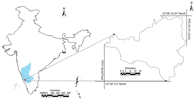
Figure1: Kumaradhara River Basin
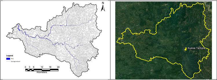
Figure 2: Kumaradhara Drainage network and Basin on Google Earth
Gundia river that flows in Sakleshpura taluk (as tributary) joins Kumaradhara (that flows from Kodagu) at Dolpadi Village and Koodige Ulippu of Kuttruppady Village, Puttur Taluk, Dakshina Kannada district. This river further joins Netravathi river at Uppinangadi village of Puttur taluk.
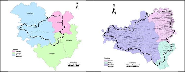
Figure 3: Administrative regions (taluk and village) under Kumaradhara River Basin
The river is located in the Malnad region of Western Ghats, the topography is undulating with moderate hills and linear ridges. Rainfall in the basin varies from 3000 mm to over 4250 mm annually. Spatial variation of rainfall based on the data for the period 1901 to 2010 is depicted in Figure 4.
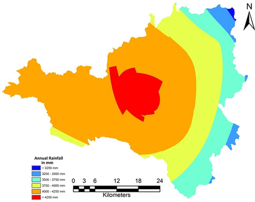
Figure 4: Spatial variation of annual rainfall (1901 – 2010) in the river basin
|
|
T.V. Ramachandra
Centre for Sustainable Technologies,
Centre for infrastructure, Sustainable Transportation and Urban Planning (CiSTUP),
Energy & Wetlands Research Group, Centre for Ecological Sciences, Indian Institute of Science, Bangalore – 560 012, INDIA.
E-mail : cestvr@ces.iisc.ac.in
Tel: 91-080-22933099/23600985,
Fax: 91-080-23601428/23600085
Web: http://ces.iisc.ac.in/energy
Subash Chandran M.DEnergy & Wetlands Research Group, Centre for Ecological Sciences, Indian Institute of Science, Bangalore – 560 012, INDIA.
E-mail:
mds@ces.iisc.ac.in
H. Surya Prakash Shenoy
Member, Tree Authority Mangalore (Rural), Government of Karnataka
G.R. Rao
Energy & Wetlands Research Group, Centre for Ecological Sciences, Indian Institute of Science, Bangalore – 560 012, INDIA.
E-mail:
grrao@ces.iisc.ac.in
S. Vinay
Energy & Wetlands Research Group, Centre for Ecological Sciences, Indian Institute of Science, Bangalore – 560 012, INDIA.
E-mail:
vinay@ces.iisc.ac.in
Vishnu Mukri
Energy & Wetlands Research Group, Centre for Ecological Sciences, Indian Institute of Science, Bangalore – 560 012, INDIA.
Sreekanth Naik
Energy & Wetlands Research Group, Centre for Ecological Sciences, Indian Institute of Science, Bangalore – 560 012, INDIA.
Citation: Ramachandra T.V, Subash Chandran M.D, Surya Prakash Shenoy H, Rao G.R., Vinay S, Vishnu Mukri and Sreekanth Naik, 2012. Kumaradhara River Basin, Karnataka Western Ghats: Need for Conservation and Sustainable Use., Sahyadri Conservation Series 24, ENVIS Technical Report : 54, April 2013, Energy & Wetlands Research Group, Centre for Ecological Sciences, Indian Institute of Science, Bangalore 560 012.
| Contact Address : |
| |
Dr. T.V. Ramachandra
Energy & Wetlands Research Group,
Centre for Ecological Sciences,
New Biological Sciences Building, 3rd Floor, E-Wing, Lab: TE15
Indian Institute of Science, Bangalore – 560 012, INDIA.
Tel : 91-80-22933099 / 22933503(Ext:107) / 23600985
Fax : 91-80-23601428 / 23600085 / 23600683 [CES-TVR]
E-mail : cestvr@ces.iisc.ac.in, energy@ces.iisc.ac.in,
Web : http://wgbis.ces.iisc.ac.in/energy |