|
|
ENVIS Technical Report 124, October 2017 |
CONSTRUCTED WETLANDS FOR TERTIARY TREATMENT OF WASTEWATER |
BANGALORE: CITY OF WETLANDS / LAKES
Most efficient way of rainwater harvesting is through lakes, which also help in mitigating floods, ground water recharge and sustain local livelihood (fish, fodder, etc.)
Bangalore (Figure 2.1) is located in the Deccan plateau, toward the south 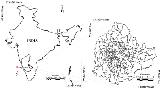 east of Karnataka state extending from 12o49’5”N to 13o8’32”N in latitude and 77o27’29” E to 77o47’2”E in longitude. Bangalore city was known as “LAND OF LAKES”, taking the advantage of undulating terrain, earlier rulers had created inter connected water bodies (during 1800) to meet the drinking water and irrigation water requirement. There were 1452 water bodies in the current spatial extent (741 sq.km.) of Bangalore. However, during post independent era, with globalization the city lost its glory due to unplanned, unrealistic and irresponsible urbanisation with the fragmented governance by the senseless decision makers.
Figure 2.1: Bangalore (Bengaluru) City
Bangalore City was once aptly known as ‘city of lakes’ due to the presence of large number of lake. These lakes were all interconnected with canals / drains (kaluveys’s) to enable transferring excess water to the next lake. These lakes catered the basic needs such as maintaining and recharging ground water, drinking water to the surrounding people, habitat for fishes and other aquatic ecosystems, sustaining food (fish, etc.) and agricultural activities, etc.
The drainage network in Bangalore carries water to the River Cauvery through its tributaries Arkavathi, Pinakini or Pennar and Shimsha. The central, northern and eastern portion is undulating with the upland tracts occupied by scrubs, while the low lands occupied by series of tanks formed by embanking the streams along the valley. These valleys consists of varying size water bodies from small ponds to large lakes. The southern portion of the land consists of hills that are close together and are surrounded by thick jungles.
Bangalore being located on the ridge, forms three watersheds as precipitation flows as runoff in three directions along the valleys (Figure 2.2) - Koramangala Challaghatta Valley (K&C Valley), Hebbal Valley (H Valley) and the Vrishabhavati Valley (V Valley). Under the administrative boundary of Bruhat Bengaluru, K&C valley is the largest encompassing an area of 255 square kilometers, followed by Hebbal valley with an area of 207 square kilometers and Vrishabhavati valley with an area of 165 square kilometers. Both K&C valley and Hebbal valley joins at Nagondanahalli village (BBMP Ward 94 – Hagadur) which further flow to Dakshina Pinakini River, where as Vrishabhavati valley joins Arkavathi river which is a tributary of river Cauvery.
The number of lakes in Bangalore has reduced from nearly 285 (spatial extent of Bangalore: 161 sq.km. in early seventies) to 194 (spatial extent of Bangalore: 741 sq.km. in 2006). Unplanned rapid urbanisation during late nineties, witnessed large-scale unrealistic, uncontrolled developmental activities in the neighborhood of lakes, which led to
- encroachment of lakes and storm water drains resulting in decline in ground water table, while increasing the instances of flooding;
- decline in native species of biota in the lake ecosystem;
- dumping of solid waste (MSW), Construction debris, etc. in storm water drains, lake catchment and in lakes.;
- sustained inflow of partially or untreated sewage, polluting existing surface and subsurface water resources;
- reduced water holding capacity due to accumulation of silt; construction debris, etc.;
- topography alterations in the lake catchment;
- sustained inflow of untreated industrial effluents; and
- pollution due to enhanced vehicular traffic.
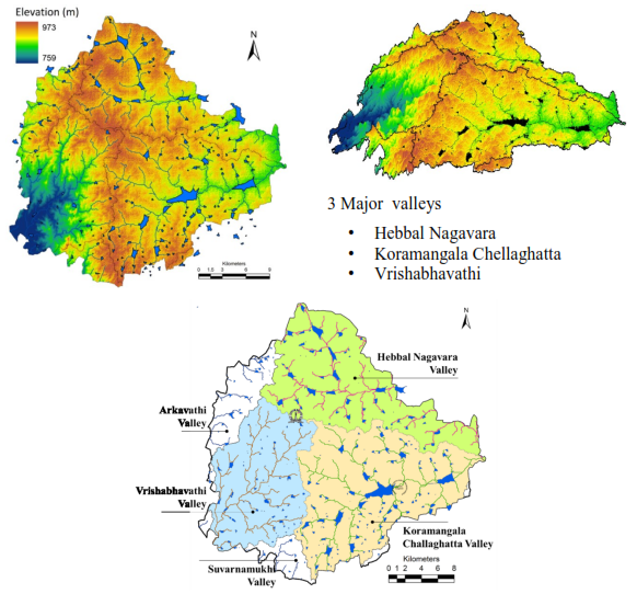
Figure 2.2: River and Lake network along the Major valleys
Anthropogenic activities particularly, indiscriminate disposal of industrial effluents and sewage wastes, dumping of building debris have altered the physical, chemical as well as biological integrity of the ecosystem. This has resulted in the ecological degradation, which is evident from the current ecosystem valuation of wetlands. Valuation of goods and services from a relatively pristine wetland in Bangalore shows the value of Rs. 10,435/ha/day (much higher than global coastal wetland ecosystems with a total annual of US$ 14,785/ha), while the polluted wetland shows the value of Rs.20/ha/day (Ramachandra et al., 2005) and sewage fed Varthur wetland has a value of Rs.119/ha/day (Ramachandra et al., 2011). The pollutants and subsequent contamination of the wetland has telling effects such as disappearance of native species, dominance of invasive exotic species (such as African catfish, water hyacinth, etc.), in addition to profuse breeding of disease.
2.1 STATUS OF LAKES – SCOPE FOR HARVESTING RAINWATER |
The number of lakes in Bangalore has reduced from nearly 285 (1970’s; spatial extent of Bangalore is 161 sq.km) to 194 (2016; spatial extent is 741 sq.km). During the last four decades there has been 79% reduction in water bodies and the number of lakes in Bangalore is given in Figure 2.3.
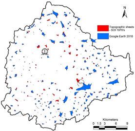
Figure 2.3: Status of Lake in Bangalore
(Red colour indicate lost lakes between 1970’s to 2016)
During 1800, there were 1452 water bodies with the storage capacity of 35 TMC (in the current spatial extent of 741 sq.km.). The current capacity of lakes (193 lakes) is about 5 TMC and due to siltation, the current storage capacity of the lakes is just about 1.2 TMC, i.e., nearly 387 hectares of water bodies lost apart from reduction in the storage capacity by 60%. Bangalore being located on the ridges, forms three watersheds – Koramangala Challagatta valley, Vrishbhavathi valley and Hebbal Nagavara valley. Earlier rulers of the region, created interconnected lake systems taking advantage of undulating terrain. Number of lakes in Koramangala Challaghatta valley is about 81, followed by the Vrishabhavathi valley (56) and the Hebbal Nagavara valley (46). In order to enhance the water retaining capability in the catchment, it is essential to harvest rain water. Lakes are the optimal means of rainwater harvesting at community level. This entails
- Reestablishing interconnectivity among lakes (needs to remove all encroachments without any consideration, as the water security of a region is vital than the vested interests, who have unauthorisedly occupied without respecting future generation’s food and water security. This would also reduce the frequency of floods and consequent damage to life and property,
- removal of all encroachments of lakes and lake bed,
- rejuvenation and regular maintenance of water bodies - this involves desilting of lakes to (a) enhance the storage capacity to retain rainwater, (b) increase the recharge potential – will improve groundwater table, (c) ensure recharging without any contamination,
- allowing only treated sewage (removal of chemical and biological contaminants) through adoption of integrated wetlands ecosystem (Jakkur lake model),
- creation of wetlands with native vegetation and regular harvesting of macrophytes; food and fodder, which supports local people’s livelihood, and
- maintaining at least 33% green cover with native vegetation (grass, trees, shrubs) in the catchment and maintaining riparian vegetation in the buffer region. This would help infiltration of water and retain this water.
Sufficient water is available to meet everyone’s requirement (Figure 2.4: Optimal water management through 5R’s): (i) water harvesting is undertaken through surface water bodies (14.8 TMC); this requires rejuvenation of lakes and reestablishment of interconnectivity; harvesting of rainwater (at decentralized levels), treatment; (ii) treatment and reuse of sewage (16.04 TMC). However, the success of sustainable water path depends on the political will, bureaucracy shedding their colonial style of functioning and more importantly citizen’s assertion for their right for equal quantity and quality of water.
- Average annual rainfall in Bangalore is about 787 mm with 75% dependability and return period of 5 years. Catchment wise water yield analysis indicates about 49.5% (7.32 TMC) of water yield in the Vrishabhavathi valley (including Arkavathi and Suvarnamukhi), followed by 35.2% (5.2 TMC) in Koramangala Challaghatta valley and 15.3% (4.2 TMC) in Hebbal valley and the total annual water yield in Bengaluru is about 14.80 TMC. Domestic demand of water (at 150 lpcd) is 20.05 TMC per year (1573 MLD). This means about 73% of Bangalore’s water demand can be met by efficient harvesting of rain water. Quantification of sewage generated shows that about 16.04 TMC (1258 MLD) of sewage is generated in the city.
- Sewage treatment with complete removal of nutrients and chemical contaminants can be achieved by adopting decentralized treatment plants similar to the success model (secondary treatment plant integrated with constructed wetlands and algae pond) at Jakkur lake. In addition to this, water available with efficient rainwater harvesting is about 14.8 TMC. This accounts to total of 30.85 TMC of water that is available annually would cater the demand of 20.05 TMC, provided the city administration opts for decentralized optimal water management through (i) rainwater harvesting by rejuvenating lakes - the best option to harvest rain water is through interconnected lake systems, (ii) treatment of sewage generated in households in each locality (opting the model functional since 2010 at Jakkur lake – STP (Sewage Treatment Plant) integrated with constructed wetlands and algal pond; (iii) conservation of water by avoiding the pilferages (due to faulty distribution system); (iv) ensuring water supply 24x7 and (v) ensuring all sections of the society get equal quantity and quality of water. Rejuvenating lakes in the region helps in retaining the rain water. Treating sewage and options to recycle and reuse would minimize the demand for water from outside the region.
Availability |
Water yield (rain) |
14.80 TMC |
|
Sewage (generation 20.05 TMC) if treated |
16.04 TMC |
|
Total |
30.84 TMC |
Demand |
Domestic purposes (@ 150 lpcd)
If @ 135 lpcd |
20.05 TMC
18.34 TMC |
Status |
Surplus |
10.79 -12.50 TMC |
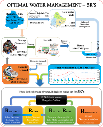
Figure 2.4: Sustenance of Water through Optimal water management with 5R’s |
2.2 RESTORATION OF WETLANDS
The loss of ecologically sensitive wetlands is due to the unplanned urbanisation due to fragmented governance with numerous para-state agencies. This is due to a lack of decentralized governance, which has led to unsustainable use of the land and other resources. Failure to deal with water as a finite resource is leading to the unnecessary destruction of lakes and marshes that provide us with water. This failure in turn is threatening all options for the survival and security of plants, animals, humans, etc. There is an urgent need for:
- Restoring and conserving the actual source of water—the water cycle and the natural ecosystems that support it—are the basis for sustainable water management.
- Reducing the environmental degradation that is preventing in attaining the goals of good public health, food security, and better livelihoods.
- Improving the human quality of life that can be achieved in ways while maintaining and enhancing environmental quality.
- Reducing greenhouse gases to avoid the dangerous effects of climate change is an integral part of protecting freshwater resources and ecosystems.
A comprehensive approach to water resource management is needed to address the myriad water quality problems that exist today from nonpoint and point sources as well as from catchment degradation. Watershed-based planning and resource management is a strategy for more-effective rejuvenation, protection and restoration of aquatic ecosystems and for protection of human health. In this regard, recommendations to improve the situation of the lakes are:
- The need for good integrated governance systems in place with a single agency with statutory and financial autonomy to act as the custodian of lakes for maintenance and action against polluters.
- Effective judicial systems for speedy disposal of conflicts related to encroachment
- Access to information for the public through digitisation of land records and availability of this geo-referenced data with query based information systems
- Measures to clean and protect lakes
- Removal of encroachments from lakes, lake water beds and storm water drains, regular cleaning of lakes.
- Proper measures such as fencing to protect lakes and prevent solid waste from going into lakes
- Install water fountains (music fountains) which enhances the aesthetic value of the lake and also aid as recreation facility to IT professionals (working in IT sector in this locality) and elderly people. This also helps in enhancing oxygen levels through aeration.
- Introduce ducks (which helps in aeration)
- Introduces fish (surface, column and benthic dwellers) which helps in maintaining food chain in the aquatic ecosystem. This has to be done in consultation with fish experts.
- No exotic fish species introduction avoid commercial fish culturing (commercial fishery)
-
Decentralised treatment of sewage and solid waste (preferably at ward levels). Sewage generated in a locality /ward is treated locally and letting only treated sewage into the lake (Integrated wetlands ecosystem as in Jakkur lake). Integrated wetlands system consists of sewage treatment plant, constructed wetlands (with location specific macrophytes) and algal pond integrated with a lake. Constructed wetland aid in water purification (nutrient, heavy metal and xenobiotics removal) and flood control through physical, chemical, and biological processes. When sewage is released into an environment containing macrophytes and algae a series of actions takes place. Through contact with biofilms, plant roots and rhizomes processes like nitrification, ammonification and plant uptake will decrease the nutrient level (nitrate and phosphates) in wastewater. Algae based lagoons treat wastewater by natural oxidative processes. Various zones in lagoons function equivalent to cascaded anaerobic lagoon, facultative aerated lagoons followed by maturation ponds. Microbes aid in the removal of nutrients and are influenced by wind, sunlight and other factors (Ramachandra et al., 2014). This model is working satisfactorily at Jakkur. The sewage treatment plant removes contaminants (evident from lower COD and BOD) and mineralises organic nutrients (NO3-N, PO43- P to inorganic constituents. Integration of the conventional treatment system with wetlands [consisting of reed bed (with typha etc.) and algal pond] would help in the complete removal of nutrients in the cost effective way. Four to five days of residence time in the lake helps in the removal of pathogen apart from nutrients. However, this requires regular maintenance through harvesting macrophytes and algae (from algal ponds). Harvested algae would have energy value, which could be used for biofuel production. The combined activity of algae and macrophytes helps in the removal of ~45% COD, ~66 % BOD, ~33 % NO3-N and ~40 % PO43- P. Jakkur lake acts as the final level of treatment that removes ~32 % COD, ~23% BOD, ~ 0.3 % NO3-N and ~34 % PO43- P. The lake water with a nominal effort of sunlight exposure and filtration would provide potable water. Replication of this model in rapidly urbanizing landscapes (such as Bangalore, Delhi, etc.) would help in meeting the water demand and also mitigating water scarcity through recharging of groundwater sources with remediation.
- Better regulatory mechanisms such as
- To make land grabbing a cognizable, non bailable offence
- Implementation of the polluter pay principle
- Ban on construction activities in the valley zones
- Restriction of diversion of the lakes for any other purposes
- Decentralised treatment of sewage and solid waste and restriction for entry of untreated sewage into the lakes
- Encouraging involvement of local communities: Decentralised management of lakes through involvement of local communities in the formation of local lake committees involving all stakeholders.
|
Dr. T.V. Ramachandra
Centre for Sustainable Technologies, Centre for infrastructure, Sustainable Transportation and Urban Planning (CiSTUP), Energy & Wetlands Research Group, Centre for Ecological Sciences, Indian Institute of Science, Bangalore – 560 012, INDIA.
E-mail : tvr@iisc.ac.in
Tel: 91-080-22933099/23600985,
Fax: 91-080-23601428/23600085
Web: http://ces.iisc.ac.in/energy
Sudarshan P. Bhat Energy & Wetlands Research Group, Centre for Ecological Sciences, Indian Institute of Science, Bangalore – 560 012, INDIA.
E-mail: sudarshanb@iisc.ac.in
Vinay S.Energy & Wetlands Research Group, Centre for Ecological Sciences, Indian Institute of Science, Bangalore – 560 012, INDIA.
E-mail: svinay@iisc.ac.in
Citation:Ramachandra T V, Sudarshan Bhat and Vinay S, 2017. Constructed Wetlands for Tertiary treatment of Wastewater, ENVIS Technical Report 124, Energy & Wetlands Research Group, CES, Indian Institute of Science, Bangalore 560012
| Contact Address : |
| |
Dr. T.V. Ramachandra
Energy & Wetlands Research Group,
Centre for Ecological Sciences, TE 15, New Biology Building, Third Floor, E Wing, [Near D Gate], Indian Institute of Science, Bangalore – 560 012, INDIA.
Tel : 91-80-22933099 / 22933503-extn 107
Fax : 91-80-23601428 / 23600085 / 23600683 [CES-TVR]
E-mail : tvr@iisc.ac.in, energy@ces.iisc.ac.in,
Web : http://wgbis.ces.iisc.ac.in/energy |
|