|
|
 |
| CONSERVATION AND MANAGEMENT OF WETLANDS |
The loss of ecologically sensitive wetlands is due to the uncoordinated pattern of urban growth happening in Bangalore. This is due to a lack of good governance and decentralized administration evident from lack of coordination among many Para-state agencies, which has led to unsustainable use of the land and other resources. Failure to deal with water as a finite resource is leading to the unnecessary destruction of lakes and marshes that provide us with water. This failure in turn is threatening all options for the survival and security of plants, animals, humans, etc. There is an urgent need for:
A comprehensive approach to water resou
Restoring and conserving the actual source of water - the water cycle and the natural ecosystems that support it - are the basis for sustainable water management
Reducing the environmental degradation that is preventing us from reaching goals of good public health, food security, and better livelihoods world-wide
Improving the human quality of life that can be achieved in ways while maintaining and enhancing environmental quality
Reducing greenhouse gases to avoid the dangerous effects of climate change is an integral part of protecting freshwater resources and ecosystems.
A comprehensive approach to water resource management is needed to address the myriad water quality problems that exist today from non-point and point sources as well as from catchment degradation. Watershed-based planning and resource management is a strategy for more effective protection and restoration of aquatic ecosystems and for protection of human health. The watershed approach emphasizes all aspects of water quality, including chemical water quality (e.g., toxins and conventional pollutants), physical water quality (e.g., temperature, flow, and circulation), habitat quality (e.g., stream channel morphology, substrate composition, riparian zone characteristics, catchment land cover), and biological health and biodiversity (e.g., species abundance, diversity, and range).


Figure 5: Temperature profile in various directions. X axis – Movement along the transacts from the city centre, Y-axis - Temperature (°C)

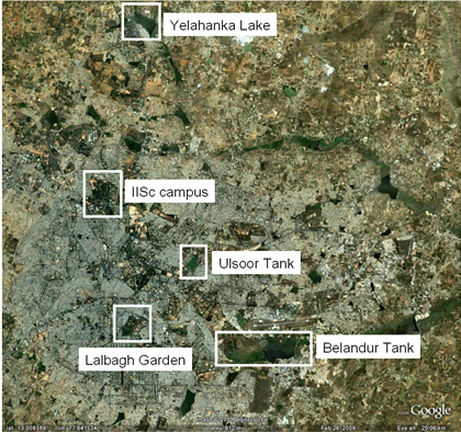
Figure 6: Google Earth image showing the low temperature areas (refer figure 7).
[Source: http://earth.google.com/]