MATERIALS AND METHODS
Study site
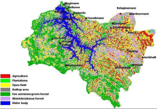
The study area is situated a little interior to the eastern corridors of the great chain of Western Ghat ranges (Shimoga district, Karnataka) gradually climaxing into evergreen as one moves west. The area shown in Figure 1 is a part of a larger study area in Linganamakki catchment region of Sharavathi river basin. It falls under two taluks - Sagar and Hosanagar (74o67’11” to 75o30’63” E and 13o77’08” to 14o7’27” N) of Shimoga district. In the past few decades, large areas under forests have been cleared for hydroelectric projects, plantations, mining, and for agriculture. In the upper catchment area, the forests in eastern regions unlike those of western part are highly fragmented and being surrounded by human habitations. Many of the original evergreen and semi-evergreen forests are surviving as isolated forests administratively classified as minor forests, smaller state forest and bits of ‘proper forests’ under the category Kans. However, some larger forest patches of more than 3000 ha are also present. The same is the case with moist deciduous forests, which makes up most part of the Sagar taluk and to a lesser extent in Hosanagar taluk. Anthropic pressure increases more towards the densely populated eastern parts of the taluks where the human needs are not being paralleled with forest resources as both the taluks depend extensively on these forests for fuelwood and other resources. Hence, even the remaining forests are being gradually transformed into other landuse types.
Figure 1: Linganamakki catchment area (Sagar, Hosanagar and Tirthahalli taluks)
Climate
Rainfall is highly seasonal, with most of the annual 2381.98 mm falling during June to October wet season. However, it decreases as one proceeds towards the east from the Ghats region (west). April is the hottest month with the mean daily maximum temperature 35.8 o C and the mean minimum 22.2 o C. In December the mean daily maximum temperature is 29.2 o C and mean minimum 9 o C.
Methods
To understand the floristic diversity in the region, a transect consisting of alternate 20 x 20 m quadrats were used for sampling the habitat. Transect length depended on the species composition and diversity. All the trees at or above 10 cm diameter at breast height (DBH) or 30 cm girth at breast height (GBH) were enumerated at 1.3 m above ground, identified, or samples collected (whenever possible) if field identification was not possible and were pressed for herbaria for future identification. Other features like epiphytes, climbers, parasites, any disturbances like lopping, logging etc., were also noted. Canopy cover was noted and ground litter quantity was weighed. Shrubs (GBH less than 30 cm and height more than 1 m) were enumerated in two shrub quadrats of 5 x 5 m laid diagonally inside the 20 x 20 m quadrat. Inside each shrub quadrat two 1 x 1 m herb plots (height less than 1 m) were laid diagonally and studied. Also general information such as ground control points using a Global Positioning System (GPS), name of the locality, range, human activities such as lopping, logging, Non-Timber Forest Produce (NTFP), fuel and litter collections, fire incidence, grazing etc. were noted down.