|
Ecological Approach for Mitigation of Urban Flood Risks
|
|
1Energy & Wetlands Research Group, Centre for Ecological Sciences [CES], Indian Institute of Science, Bangalore – 560012, India.
*Corresponding author: cestvr@ces.iisc.ernet.in
Study Area
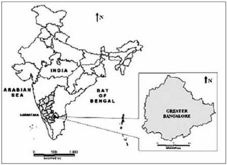
Greater Bangalore (77°37’19.54’’ E and 12°59’09.76’’ N) is the principal administrative,
cultural, commercial, industrial, and knowledge capital of the state of Karnataka with an
area of 741 sq. km. Bangalore city administrative jurisdiction was widened in 2006 by
merging the existing area of Bangalore city spatial limits with 8 neighbouring Urban Local
Bodies (ULBs) and 111 Villages of Bangalore Urban District (Ramachandra and Uttam
Kumar, 2008; Sudhira et al., 2007). Thus, Bangalore has grown spatially more than ten
times since 1949 (69 square kilometers) and is a part of both the Bangalore urban and rural
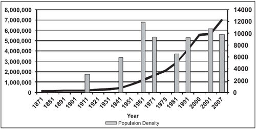
districts (figure 1). Now, Bangalore is the fifth largest metropolis in India currently with a
population of about 7 million (figure 2). The mean annual total rainfall is about 880 mm with
about 60 rainy days a year over the last ten years. The summer temperature ranges from 18°
C – 38° C, while the winter temperature ranges from 12° C – 25° C. Thus, Bangalore enjoys
a salubrious climate all round the year. Bangalore is located at an altitude of 920 meters
above mean sea level, delineating four watersheds, viz. Hebbal, Koramangala, Challaghatta
and Vrishabhavathi watersheds. The undulating terrain in the region has facilitated creation
of a large number of tanks providing for the traditional uses of irrigation, drinking, fishing
and washing. This led to Bangalore having hundreds of such water bodies through the
centuries. Even in early second half of 20th century, in 1961, the number of lakes and tanks
in the city stood at 262 (and spatial extent of Bangalore was 112 sq km). However, number
of lakes and tanks in 1985 was 81 (and spatial extent of Bangalore was 161 sq km).
Figure 1: Study area – Greater Bangalore
Figure 2: Population growth and population density
|
|
Citation : Ramachandra T. V., Uttam Kumar and Bharath H. Aithal, (2012), Ecosystem Approach for Mitigation of Urban Flood Risks. Chapter 7, In: Ecosystem Approach to Disaster Risk Reduction (Eds. Anil K. Gupta and Sreeja, S. Nair). Published by National Institute of Disaster Management (NIDM), Ministry of Home Affairs, Govt. of India, IIPA Campus, New Delhi - 110002, India, pp 103-119.
|