|
RESULTS AND DISCUSSION
MANGROVE AREA ESTIMATES: ADMINISTRATIVE JURISDICTION-WISE
Bhatkal range: Venkatapur estuary (184.6 ha) of the range has some creeks also namely Bhatkal creek (45.43 ha), Belke creek (10 h), Jali creek (7.53 ha) etc. Mangroves are found mainly in Shirali beat of Shirali section, Bhatkal beat of Bhatkal section; and very little area Belke beat (Table 1 & Figures 2-3&4)
| Table. 1: Beat wise Area under Mangroves and potential area in Honavar Forest Division |
| RANGE |
SECTION |
BEAT |
Beat Area (ha) |
Mangrove area (ha) |
Total area for planting (ha) |
Rivers |
Taluk |
| Bhatkal |
Belke |
Belke |
2773 |
0.07 |
NA |
Belke creek |
Bhatkal |
| Hadeen |
2074 |
0.14 |
NA |
Belke creek, Tannirmadi creek |
Bhatkal |
| Bhatkal |
Bhatkal |
4538 |
25.39 |
8.676 |
Venkatapur estuary |
Bhatkal |
| Shirali |
Shirali |
3931 |
10.79 |
14.089 |
Venkatapur estuary |
Bhatkal |
| Manki |
Mavalli |
Mavalli |
3738 |
3.35 |
NA |
Mavalli creek |
Bhatkal |
| Manki |
Manki |
2648 |
0.62 |
0.467 |
Manki creek |
Honavar |
| Honavar |
Hadinbal |
Hadinbal |
2227 |
0.22 |
NA |
Sharavathi estuary(Hadinbal river) |
Honavar |
| Jalvalli |
2605 |
0.53 |
0.525 |
Sharavathi estuary(Hadinbal river) |
Honavar |
| Honavar |
Haldipur |
3232 |
13.53 |
26.13 |
Badgani estuary |
Honavar, Kumta |
| Honavar |
5707 |
49.07 |
30.57 |
Sharavathi-Badgani esturine complex |
Honavar |
| Kasarkod |
4507 |
54.48 |
99.43 |
Sharavathi estuary |
Honavar |
| Salkod |
Aunsalli |
2952 |
9.96 |
4.454 |
Badgani estuary |
Honavar, Kumta |
| Kumta |
Chandavar |
Chandavar |
3038 |
0.87 |
NA |
Badgani estuary |
Kumta, Honavar |
| Kumta |
4820 |
22.99 |
67.866 |
Badgani estuary, Kumta creek, Dhareshwar creek |
Kumta, Honavar |
| Manaki |
5158 |
26.49 |
22.827 |
Aghanashini estuary |
Kumta |
| Katgal |
Katgal |
Katgal |
2386 |
0.24 |
NA |
Aghanashini estuary |
Kumta |
| Mirjan |
Mirjan |
3287 |
83.85 |
35.669 |
Aghanashini estuary |
Kumta |
| Hiregutti |
Gundubala |
Kenkani-Shivapura |
1926 |
3.93 |
1.402 |
Gangavali estuary |
Ankola |
| Moralli |
1534 |
0.35 |
NA |
Gangavali estuary |
Ankola |
| Hiregutti |
Hiregutti |
2756 |
21.94 |
157.69 |
Aghanashini estuary |
Kumta |
| Madangeri |
Madangeri |
7233 |
61.93 |
549.30 |
Gangavali estuary, Aghanashini estuary |
Kumta, Ankola |

Figure. 2: Beat-wise mangrove area vs number of patches
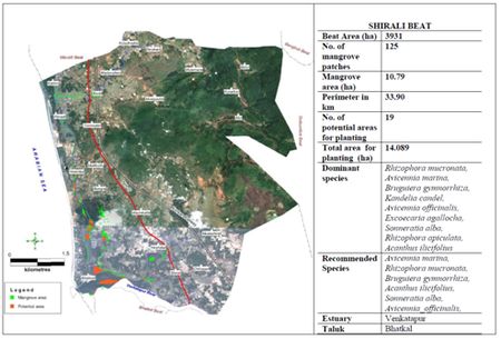
Figure. 3: Shirali beat
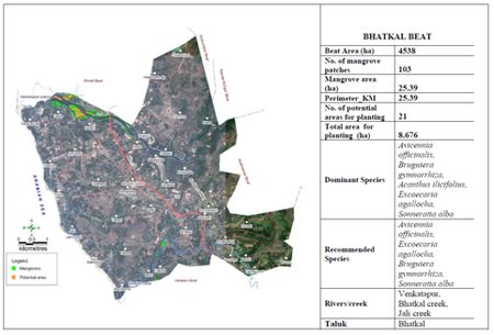
Figure. 4: Bhatkal beat
Honavar Range: Of the 3043 ha of Sharavathi –Badgani esturine complex, 2240 ha falls in Honavar Range. Mangroves occur in Kasarkod, Honavar and Haldipur beats of Honavar section, Aunsalli beat of Salkod section and Hadinbal and Jalvalli beats of Hadinbal section (Table 1 & Figures 2,5,6&7).
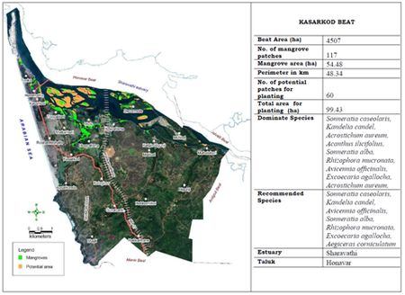
Figure.5: Kasarkod beat
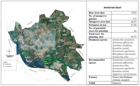
Figure. 6: Honavar beat
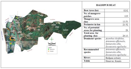
Figure.7: Haldipur beat
Kumta Range: Out of Aghanashini estuarie’s total waterspread area of 4,950 ha, 1,466 ha and 255 ha of Badagini estuary falls in the range, apart from Kumta creek (238 ha) and Dhareshwar creek (4 ha). Mangroves are found in Kumta, Manaki and Chandavar beats (Table 1 & Figures 2,8&9).
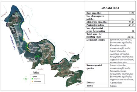
Figure.8: Manaki beat
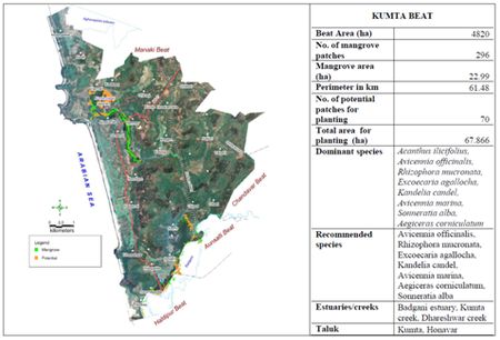
Figure. 9: Kumta beat
Katgal Range: About 1158 ha of Aghanashini is under this range. Mangroves occur in Mirjan and Katgal beats (Table 1 & Figure 2&10).
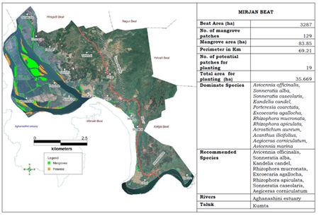
Figure.10: Mirjan beat
Hiregutti Range: By far most area under mangroves in Honavar Forest Division is under this range which has parts of Gangavali and Aghanashini estuaries under it (Table 1 & Figures 2, 11&12).
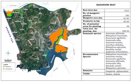
Figure.11: Madangeri beat
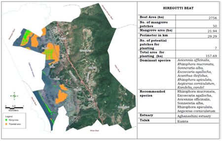
Figure. 12: Hiregutti beat
ESTUARY-WISE MANGROVE SITUATION
HONAVAR FOREST DIVISION: Among the estuaries Aghanashini topped the list with 169 ha of mangroves and 711 ha of potential area for planting followed by Sharavathi-Badgani estuarine complex (136 ha and 184 ha respectively -Table 2 & Figure 13) apart from t creeks to a lesser extent.
Table 2. Estuary and creek-wise details of mangrove area and potential area for planting
| Sn |
Estuary name |
Mangrove area(ha) |
Potential area (ha) |
Total water spread Area (ha) |
| 1 |
Gangavali estuary, |
45.93 |
95.29 |
817.10 |
| 2 |
Aghanashini estuary |
169.40 |
711.00 |
5236.00 |
| 3 |
Kumta creek |
14.23 |
42.42 |
238.10 |
| 4 |
Dhareshwar creek |
1.43 |
2.57 |
4.02 |
| 5 |
Sharavathi-Badgani estuarine complex |
136.20 |
184.40 |
3415.00 |
| 6 |
Apsarkonda creek |
0.14 |
0.00 |
1.30 |
| 7 |
Manki creek |
0.62 |
0.47 |
21.63 |
| 8 |
Mavalli creek |
3.06 |
0.00 |
17.80 |
| 9 |
Murudeshwar creek |
0.37 |
0.00 |
35.37 |
| 10 |
Venkatapur estuary |
20.54 |
22.77 |
219.20 |
| 11 |
Jali creek |
0.02 |
0.00 |
5.40 |
| 12 |
Bhatkal creek |
1.69 |
0.00 |
53.22 |
| 13 |
Huvilmadi creek (Hadeen Creek) |
0.10 |
0.00 |
13.71 |
| 14 |
Belke creek |
0.12 |
0.00 |
5.97 |
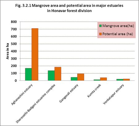
Figure.13: Estuary -wise details of mangrove area vs. number of patches
GANGAVALI ESTUARY: The Gangavali or Bedti River, forming the northern boundary of Honavar Division (Figure 14), has 571 ha of estuary. The mangroves are more of fringing type in linear formations near borders. Some denser patches occur in Nadumaskeri, Agragon, Hadav, Joog, and Ulware. Dense mangroves, linear mangroves and sapling areas are also shown in the figure. Nadumaskeri has the largest area (18.57 ha) under mangroves and more potential area (17.24 ha) for planting (Table 2). Using IRS p6L4 MX5 M imagery the details of landscape/waterscape elements observed in the estuarine belt as a whole (total waterspread area) are given in the Table 3 & Figure-15.
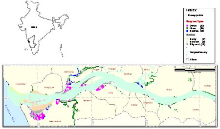
Figure 14. Gangavali estuary: mangrove areas and nature of bottom sediments
Table 3. Gangavali estuary: Area under tree mangroves (for 3 species) and other landscape/waterscape elements (based on 2010 IRS p6L4 MX5 M imagery)
| Category LSE/WSE |
Area in ha |
% |
| Rhizophora mucronata |
3.010 |
0.46 |
| Sonneratia alba |
1.903 |
0.29 |
| Avicennia_officinalis |
2.088 |
0.32 |
| Other vegetation |
36.465 |
5.58 |
| Open water |
620.996 |
76.6 |
| Estuarine fields |
102.622 |
15.72 |
| Plantations |
6.693 |
1.03 |
| Total area |
817.1 ha |
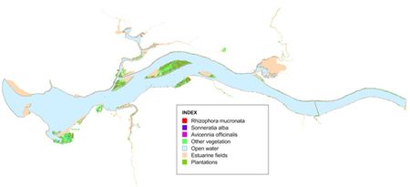
Figure 15. Gangavali estuary: species-wise tree mangrove distribution and other landscape/waterscape elements (based on 2010 IRS p6L4 MX5 M imagery)
AGHANASHINI ESTUARY: The estuary is 13 km long and 2 to 6 km broad. The expansive and shallow nature of the estuary and the presence of several mudflats make it ideal for mangroves. Details of village-wise area under mangroves and potential area for mangrove planting are shown in Table 2. Masurkurve 32 ha and Hiregutti with 23 ha have more area under mangroves. Hiregutti has 151 ha suitable area for planting followed by Madanageri with 128 ha. With almost 733 ha of potential areas for planting Aghanashini estuary could be developed as one of the finest mangrove areas of Karnataka (Figure-16).
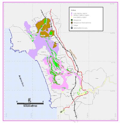
Figure 16. Aghanashini estuary: mangroves, salinity zones and potential area for planting
Using RS data from 2410 IRS p6L4 MX5 M estimates could be made of only three dominant tree mangroves namely Avicennia officinalis, Rhizophora mucronata and Sonneratia albaalongwith other landscape/waterscpe elements (Table 4 for details). The interpreted imagery is given in Figure-17
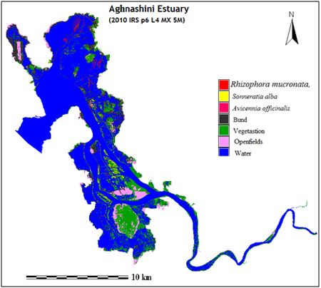
Figure 17. Aghnashini estuary: tree mangroves, other landscape/waterscape elements
Table 4. Aghnashini estuary: area under individual tree mangroves (for 3 species only) and other landscape/waterscape elements as deciphered from 2410 IRS p6L4 MX5 M imagery
| Category |
HA |
% |
| Rhizophora mucronata |
74.27 |
1.42 |
| Sonneratia alba |
33.72 |
0.65 |
| Avicennia officinalis |
5.40 |
0.11 |
| Vegetation |
857.46 |
16.37 |
| Water |
3615.19 |
69.05 |
| Open fields |
259.13 |
4.94 |
| Bund |
390.83 |
7.46 |
| Total area |
5236.00 |
SHARAVATHI -BADGANI estuarine complex: The Sharavathi River from the Western Ghats joins the sea at Honavar with an estuarine spread of 2695.8 ha, including the estuary of a smaller river Badgani, merging with former. River flows between richly wooded banks fringed with mangrove bushes. The execution of Linganmakki and Gersoppa dams for power generation resulted in dipping of salinity conditions to low levels (<0.5 ppt most of the year) resulting in the disappearance of most of high and medium salinity tolerant mangrove species from the estuary, leaving behind mostly low brackish water ones. Total area under mangroves in the Sharavathi part of estuary was about 54 ha and potential area for planting 124.7 ha. The Badgani estuary that merges with Sharavathi has higher salinity but the the mangroves are in small fragments (16.4 ha) and the potential area is only 55 ha (Table 2). Using remote sensing imagery from 2010 IRS p6L4 MX5 M area under tree mangrove species was estimated and along with other waterscape/landscape elements given in the Table 5 & Figure 18.
Table 5. Sharavathi-Badgani estuarine complex: Area under tree mangroves and other waterscape/landscape elements (based on 2410 IRS p6L4 MX5 M imagery)
| Category |
Ha |
% |
| Avicennia officinalis |
10.70 |
0.31 |
| Sonneratia alba |
23.00 |
0.67 |
| Kandelia candel |
6.81 |
0.20 |
| Rhizophora mucronata |
5.41 |
0.16 |
| Sonneratia caseolaris |
81.96 |
2.40 |
| Plantations |
219.65 |
6.44 |
| Vegetation |
515.21 |
15.08 |
| Water |
1334.90 |
39.08 |
| Open space |
1218.12 |
35.66 |
| Total area |
3415.75 |
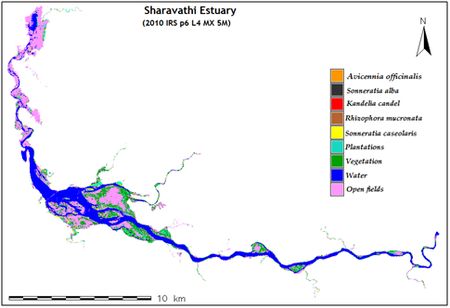
Figure 18. Sharavathi-Badgani estuarine complex: distribution of tree mangroves (4 species) and other landscape/waterscape elements
VENKTAPUR ESTUARY: Venktapur is a small west flowing river from the Western Ghats near Bhatkal town towards south-west of Uttara Kannada. (Figure 19). It has 21 ha of mangroves and 23 ha of potential area for planting (Table 2). Venktapur estuary is the only estuary in the Division with the rare presence of Bruguiera gymnorrhiza. Details from 2010 IRS p6L4 MX5 M imagery are given in Table 6 & Figure 20.
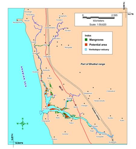
Figure 19. Venkatapur estuary: mangrove areas and potential areas
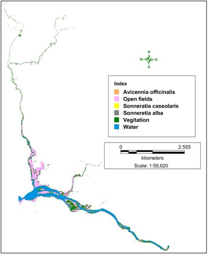
Figure 20. Venkatapur estuary: tree mangroves and other landscape/ waterscape elements
Table 6. Venkatapur estuary: area under tree mangroves (for 3 species only) and other landscape/waterscape elements (based on 2010 IRS p6L4 MX5 M imagery)
| Category |
HA |
% |
| Avicennia officinalis |
9.928 |
4.53 |
| Sonneratia caseolaris |
0.711 |
0.32 |
| Sonneretia alba |
5.636 |
2.57 |
| Vegitation |
56.545 |
25.81 |
| Open fields |
70.933 |
32.38 |
| Water |
75.336 |
34.39 |
| Total area |
219.089 |
KUMTA CREEK: This is the only notable independent creek with mangroves in the division, others being smaller and dealt with as part of the estuaries with which they are linked. The Kumta is situated on its north bank. Details regarding mangrove areas and potential areas are given in Table 2 and Figure 21
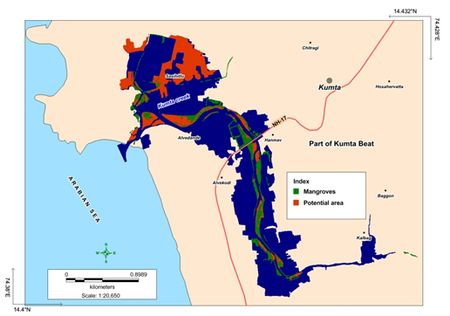
Figure 21. Kumta creek: mangroves and potential area for planting
|
