|
MATERIALS AND METHODS
Study region: Location – geography, climate, vegetation
A 600 MW Thermal Power Plant (13.158 °N, 74.797 °E) located at Yellur panchayath has been operational since June 2010 and supplying electricity to the power distribution company, MESCOM. Field investigations were carried out in a buffer zone of 6 km of TPP (Figure 1) in Yellur as well as surrounding villages of Padebetu, Nadsal (Tenka Yermal), Nandikur, Santhoor, Karnire, Bada and Palimar (and parts of other villages) located in Udupi taluk, Udupi district, Karnataka . Water and soil samples were collected from location marked in Figure 2, mainly in the core zone of 2 km around Yellur village. An ash pond is also situated nearly 3.5 km from the TPP in Santhur village (Figure 2).
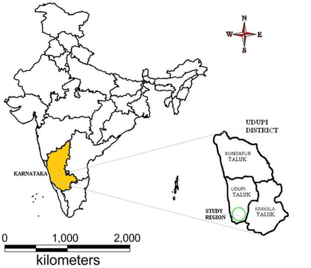
Figure 1: Study region
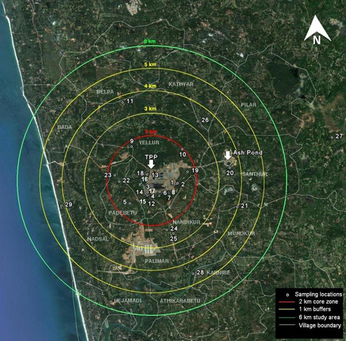
Figure 2: Sampling locations in the study region with village boundries; concentric circles 1 km apart depict the different strategic sampling zones
The region has four distinct seasons: 1) rainy season (June-September), 2) warm and damp post-monsoon season (October-November), 3) winter season (December-February) and 4) summer season (March-May). It has a maritime climate with temperatures ranging from 22°C to 36°C, annual average rainfall of 4035 mm and humidity ranging from 61 to 91 %. (India water Portal, http://www.indiawaterportal.org).
The vegetation in the region is tropical semi-wet with evergreen and deciduous type. Some of the terrestrial flora includes Acacia spp., Albizzia spp., etc. Paddy is the major crop of the region. Pulses like black gram, green gram, horse gram, cow pea; fruits like mango, banana, pineapple, jackfruit, sapota; vegetables like pumpkin, gourd, sweet potato, bean, brinjal, lady’s finger, tomato, onion, garlic; and horticultural crops like coconut, arecanut, pepper are grown in the region (Bhat, 2003). There is no any major irrigation scheme in Udupi district. The minor irrigation schemes include both surface water and ground water schemes. The ground water schemes consists of dug wells, shallow and deep tube wells, while surface water schemes includes mainly lift irrigation schemes and surface flow (tanks, anicuts, pickups, barrages).
Udupi is one of the three coastal districts of Karnataka. Nearly 20% of the work forces are cultivators and 15% are agricultural labourers. About 14% of rural people are involved in household industries. Agriculture is the predominant activity and the net sown area is highest in the taluk (37%). Low cropping intensity is reported due to lack of irrigation facilities. The area under cropping is in decline also due to high cost of cultivations and labour scarcity. Well organized and mechanized marine fishing is a major source of income for the coastal inhabitants. Large and medium scale industries in the region include cashew-nut processing, rice mills, coconut powder units, fish canning and processing, fish meals and fish oil units, fish net manufacturing, printing units, granite units, readymade garments, auto parts etc (Udupi district, Human development report 2008).The study region is part of Padubidri Industrial Area as recognized by the Karnataka Industrial Areas Development Board (KIADB).
Method
Water samples were collected depending upon accessibility and availability from open-wells, bore-wells, ponds, streams etc. within a 2 km core zone as well as 6 km buffer zone around the TPP site during August 2011. These sampling locations were assigned codes (ranging from 1 to 29) and spatially mapped over the study region (Figure 2). Two villages beyond the buffer zone were also visited for sampling to understand the impact (if any) beyond the study region. Table 1 lists the sampling locations along with villages collected during field visits. Water samples were collected in one litre disinfected (acid washed) polythene bottles. Water quality parameters were analyzed as per the standard protocol (APHA, 1995). Water samples from the core zone were analyzed for heavy metals like cadmium, chromium, copper, iron, manganese, nickel, lead and zinc. The quantitative estimation of heavy metals was done with the help of ICP - OES (Thermo-iCAP 6000 Series) to know the concentrations of heavy metals in water.
Table 1: Sampling locations in the study region
| Sampling code |
Latitude |
Longitude |
village |
sampling site |
| 1 |
13°15'68'' |
74°80'746'' |
Yellur |
Well water |
| 2 |
13°9'25.46'' |
74°48'27.89'' |
| 3 |
13°9'12.3'' |
74°47'43.55'' |
| 4 |
13° 9' 9.0354" |
74° 47' 5.1314" |
| 5 |
13° 9' 10.476" |
74° 47' 1.4594" |
| 6 |
13°9'13.09'' |
74°48''1.28'' |
| 7 |
13°9'11.56' |
74°48'14.76'' |
| 8 |
13° 9' 11.844" |
74° 48' 4.572" |
| 9 |
13° 10' 18.1554" |
74° 47' 18.239" |
| 10 |
13° 10' 14.2674" |
74° 48' 34.74" |
| 11 |
13° 11' 21.552" |
74° 47' 6.576" |
| 12 |
13° 9' 57.6354" |
74° 48' 5.22" |
| 13 |
13°9'38.73'' |
74°47'43.4'' |
Yellur |
Stream water |
| 14 |
13° 9' 10.5114" |
74° 47' 41.352" |
| 15 |
13°9'4.79'' |
74°47'46.78'' |
| 16 |
13°9'38.95'' |
74°47'44.18' |
| 17 |
13°9'8.69'' |
74°47'45.03'' |
Yellur |
Pond water |
| 18 |
13° 9' 38.7354" |
74° 47' 43.403" |
| 19 |
13°9'41.9'' |
74°48'42.74'' |
Santhur |
Well water |
| 20 |
13°9'47.63'' |
74°49'45.12'' |
| 21 |
13° 8' 51.072" |
74° 49' 56.1" |
| 22 |
13° 9' 27.4674" |
74° 47' 1.248" |
Padebetu |
Well water |
| 23 |
13° 9' 36.8994" |
74° 46' 54.804" |
| 24 |
13° 8' 47.652" |
74° 48' 1.332" |
Nandikur |
Well water |
| 25 |
13° 8' 12.9114" |
74° 48' 21.636" |
| 26 |
13° 10' 54.4434" |
74° 48' 7.8514" |
Kathyar |
Well water |
| 27 |
13° 10' 31.044" |
74° 52' 5.7794" |
Belman |
Well water |
| 28 |
13° 7' 14.8434" |
74° 48' 0.7594" |
Karnire |
Well water |
| 29 |
13°8'52.73'' |
74°45'35.54'' |
Nadsal |
Well water |
|
