|
Methods
Study area –
The field investigations were carried out in two neighbouring watersheds with similar topography, one with a sacred grove and the second without a sacred grove, in the Honavar taluk of Uttara Kannada district in the central Western Ghats of Karnataka State. The Karikan hill with a maximum height of about 450 mt. (14°20.25" – 14°22.95" N and 74°29.40" – 74°31.50" E), covered with a sacred forest of primeval dipterocarps is at the source of a stream that recharges the ground water in the Bangarmakki village in the valley below. In the vicinity of the grove is the Karikanamman temple, a popular place of mother goddess worship in the district. The Karikan watershed is spread over 460 ha, of which about ~178 ha is forest, including the sacred grove. The grove is today part of the State Reserved Forest of Karnataka, and as such has no sharp boundaries to distinguish it from the secondary forest surrounding it.
The second study area was Sambegadde, A hill, also with also maximum height of about 450 mt. with a village by same name towards its base (14°21.54" – 14°22.77" N and 74°30.50" – 74°31.58" E). The forest cover on the hill is of secondary nature, and less evergreen than Karikan with several deciduous trees. The forest turned secondary due to slash and burn cultivation in the past and no taboos associated with it regarding resource extraction (Chandran 1997, 1998). A stream draining the watershed enters the Sambegadde village. The total drainage basin covers an approximate area of ~1004 ha of which forest cover is ~239 ha. Both the study areas receive average rainfall 3713.4 mm and the temperature ranges from 15-320° C.
Major land use types in the Bangarimakki village are areca nut (Areca catechu) gardens with black pepper (Piper nigrum), betel leaf (Piper betel), banana (Musa paradisiaca) and coconut. Sampegadde has rain-fed rice (Oryza sativa) as main crop followed by ragi (Eleusine coracana) and sugarcane (Saccharum officinarum) as seasonal field crops (Table 1). Garden crops are grown in lesser areas compared to Bangarmakki. The study areas were digitized from Survey of India 1:50,000 toposheets (Fig 1.)
Table 1. Land use under major cultivated crops in the study area
|
Bangarmakki(ha) |
Sambegadde(ha) |
Areca Nut (Areca catechu) garden |
20.123 |
10.491 |
|
0.111 |
25.398 |
paddy (Oryza sativa) |
|
|
sugarcane (Saccharum officinarum) |
|
0.082 |
ragi (Eleusine coracana) |
|
0.044 |
Total cultivated land |
20.234 |
36.015 |
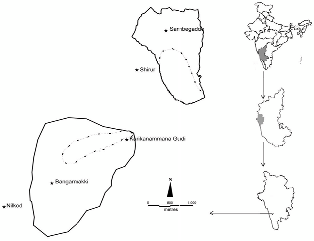
Fig 1. Study area details (Toposheet (SOI) 48_J_7, 48_J_11). Continuous line indicating watershed boundary and dotted line indicates study forest boundary.
Vegetation study –
Study of the forests covering the drainage basins of the two streams, has been carried out using transect-cum – quadrat method. Each catchment was divided into three altitudinal zones viz. low (< 200 m.), middle (200-400 m.) and high (> 400 m.). A line transect of 180 m. was laid in each altitudinal zone. Five quadrats of 20 m. X 20 m. for tree (30 cm gbh or more) inventory were laid at equal distances from each other alternately along left and right of this transect covering a total of 2000 m2 forest area. 5m. X 5m. quadrats, two each within a tree quadrat, for shrub layer including tree saplings (< 30 cm gbh) and 1m. X 1m. nested quadrat for herbs, two each within a shrub layer quadrat, were laid along the line transect .
Soil study –
Soil in the study area is broadly classified under clayey, kaolinitic and ustic kandihumults category (Anonymous 1998). Soil samples (at 0-20cm) were collected for moisture content, bulk density and total carbon. For moisture content, five samples were collected from every altitudinal zone month-wise covering the post- and pre monsoon period (January-May). Therefore, a total of 75 samples were collected from each watershed (5 samples X 3 altitudes X 5 months). Moisture content was analysed through gravimetric method, organic carbon using Walkley-Black method and bulk density through core method (Baruah & Barthakur 1997).
Ground water monitoring -
The study period was divided into pre-monsoon (April-May), monsoon (June-September) and post-monsoon (October-March) according to local weather and water availability scenario. The Sambegadde village stream dries up from late post-monsoon in January to May end in pre-monsoon, making villagers entirely depending on open wells for irrigation. The Bangarmakki stream experiences intermittent flows during the pre-monsoon. As ground water level is high villagers better use open wells for water. Therefore, we measured ground water levels in open wells and the quantum of water pumped out of them for farming and domestic needs. We selected 15 wells each in Bangarmakki and Sambegadde villages for monitoring ground water for 18 months from January 2009 to May 2010. All these wells were at an average altitude of ~50-55 m. The depth to water table was measured manually following standard techniques suggested by World Meteorological Organisation (Anonymous 1994). Data on quantities of water pumped for irrigation and domestic use, was collected through interviews.
Socio-economic survey -
Socio-economic survey was conducted in the two villages using structured questionnaire and market price method was used to estimate the cost and benefits of the ecosystem goods i.e. mainly of agricultural and horticultural crops.
Data Analysis –
Data related to ground water, soil moisture and water usage were analysed for central tendency and t-test was done for comparative analysis. Vegetation data was analysed through multivariate statistical techniques (PAST version 2.14.) (Hammer et al. 2001) included Nonmetric Multi Dimensional Scaling (NMDS), Analysis of similarity (ANOSIM) and similarity percentage analysis (SIMPER) for understanding the differences in species composition between the sites. Species richness was estimated through non-parametric richness estimators viz., ACE, ICE, Chao1, Chao2, Jack1 and Jack2 and species diversity-dominance was calculated through several indices like Fischer’s alpha, Shannon-Wiener, and Simpson (Estimate S version 8.2) (Colwell 2009). Girth class distribution was compared through Kolmogrov-Smirnov test. Canonical Correspondence Analysis (CCA) was performed with vegetation and soil data to explore the site-species relationship with soil characters. For cost – benefit analysis, expenses related to cost and profit were calculated on data collected from twenty respondents from each site, which was then summed up and averaged. Total cost and benefit were calculated by multiplying this average value with total area under horticultural and crops and the value was expressed in terms of hectare.
|
