Urban agenda: governance and infrastructure |
An important aspect of a city is how well it is planned, managed and administered, activities which form the core part of an urban agenda governance. However, appropriate state mechanisms through organisational structures, procedures and policies are needed to enable these. Also, apart from the formal administrative structures, the presence and involvement of civil society significantly drive the urban agenda.
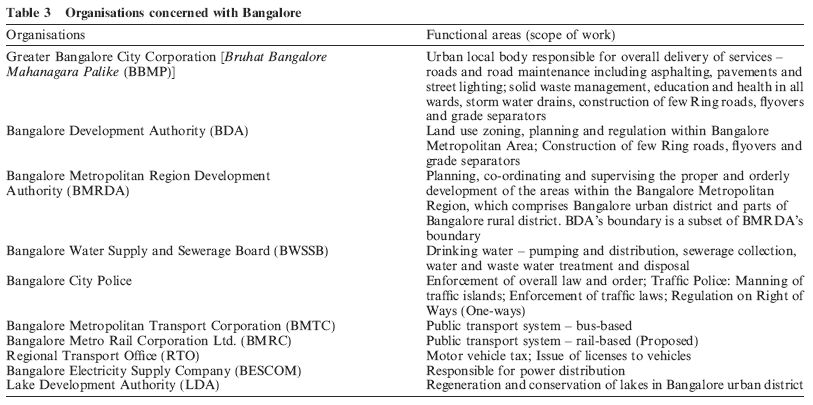
Planning in the form of land use zoning and regulation are vested with Bangalore Development Authority (BDA), a parastatal agency, in spite of the 74th Constitutional Amendment Act, passed by the national parliament in 1993. This Act requires that the planning function be vested with the (elected) urban local body and not with any parastatal agency. But, in the case of Bangalore, the Corporation have not been granted adequate powers by the State to plan, decide and administer their city! Furthermore, the State has created numerous other organisations of its own to manage various services such as water supply, law and order, energy, etc. The result is the existence of many parastatal organisations, each acting in its own geographic area, leading to complication and confusion in coordinating different activities. Apart from the issue of a common geographical unit and the lack of coordinated effort, even basic information related to different sectors is extremely diffi- cult to collect, collate and to correlate. For effective planning it is imperative that all the basic information be gathered across a common geographical unit with the effect of creating a robust city information system.
In addition to the official bodies, civil society of Bangalore is known for its vibrant community participation. The spectrum of their activities ranges from literacy and green brigades to urban governance, ensuring continuous interactions with the local administration. Notable spheres of activity of these non-governmental organisations (NGOs) include: improving urban governance by Citizens Voluntary Initiative for the City (CIVIC) and Janaagraha;improving living conditions in slums by AWAS, APSA, Paraspara, etc.; addressing child literacy by Preranaand the India Literacy Project; taking on environmental issues by the Environment Support Group, Hasiru Usiru, etc. Apart from the NGOs, there are numerous resident welfare associations, trade and commercial organisations, and professional organisations that have played a major role in some of the important activities of local bodies and influencing their decision- making. Civil society has contributed considerably in shaping the policies and governance structures and has always intervened whenever there has been any apathy on the part of the administration towards activities of interest to society at large. An experiment to promote public private partnership and bring together citizens, NGOs, industry representatives and the erstwhile local bodies resulted in Bangalore Agenda Task Force (BATF). This experiment was about to be benchmarked as one of the best practices in urban local governance, when it faced strong criticisms from several civil society groups for setting aside priorities favouring the urban poor and was accused of making a back door entry towards policy making (Ghosh, 2005). In the event, the activities of BATF came to a standstill with the change of guard at the State government two years ago and it is currently dormant. Another instance of strong action by civil society groups, was seen when the local government started tree felling and pruning for road widening. Members of the green brigade, Hasiru Usiru, staged protests, held an all night vigil, stormed the Commissioners office and also moved to High Court and fi- nally got the actions stayed. The High Court also ruled later that Hasiru Usiru members should inspect the trees along with the designated Tree Officer from the Forest Department before any tree felling and pruning of branches was begun.
Urban activities require the support of infrastructure. Broadly, urban infrastructure can be divided into social and economic infrastructure. Social infrastructure encompasses facilities like health care, education, housing, commercial (shops, markets and hotels), sports, recreation and entertainment. With mixed land use being practiced in most parts of Bangalore, shops and markets are the most commonly found amenities (approximately 1 shop per 100 persons) in the urban agglomeration(10) (Karnataka Urban Infrastructure Development and Finance Corporation, 2006). The provision and maintenance of primary health care, elementary education, sports, recreation, and entertainment are administered mostly by the Corporation, while BDA also facilitates some of the social infrastructure like shopping complexes, with provisions for private participation. Economic infrastructure encompasses water supply, wastewater treatment, storm water drainage system, solid waste management, telecommunication network, and transportation network.
Bangalore Water Supply and Sewerage Board (BWSSB) is the parastatal agency responsible for drinking water supply, and wastewater collection and treatment in the city. Bangalore is on a ridge and does not have its own year-round sources of water. Drinking water is pumped from the river Cauvery, a distance of about 100 km over an elevation of 500 m with an energy expenditure of 75 MW for approximately 900 million litres per day (MLD). Apart from the river Cauvery supply, ground water and water from the river Arkavathy are also tapped. However, while water supply distribution is 100% in the former Bangalore City Corporation limits, only about 20% of the Municipal Council households are serviced. In view of the rapid growth of the city, and recent notification of Greater Bangalore, it remains a challenge to service the remaining areas.
Regarding collection and treatment of wastewater, the sewerage system is based on the citys four natural river valleys already noted and BWSSB is the nodal agency. There are three major treatment plants with a total capacity of about 450 MLD (the outlets of Koramangala and Challaghatta valleys are combined to form the K&C Valley Treatment Plant at Bellandur). Wastewater stress on natural water bodies is evident from the fact that the present wastewater treatment capacity in the city is around 450 MLD as against an estimated generation of domestic wastewater of 700 MLD. Although more secondary wastewater treatment plants are in progress, they are yet to be completed. Another problem is the frequent clogging of storm water drains, resulting in pollution of natural water bodies. Hence it is now proposed to rehabilitate and remodel all the major trunk sewers to prevent any discharge into the storm water drains.
Addressing mobility in Bangalore city, an overview of transportation and traffic reveals the following facts. Bangalore city is estimated to have vehicle population of about 2.6 million while the current city population is about 7 million. The vehicle to person ratio is far higher than any other city in India. This has led to increased congestion in road networks across the city and frequent traffic jams. Manning signalling at traffic islands have also become unmanageable with the amount of traffic plying across junctions. Again, in this sector different components related to mobility are vested with different parastatal bodies.
Public transportation forms one of the key functionalities for mobility in any urban area. In Bangalore where the working population is around 2 million, the Bangalore Metropolitan Transport Corporation (BMTC) operates on any given day with 4144 schedules, 4262 buses, 60,475 trips, and carries 3.5 million passengers. It earns Rs. 20.5 million per day and pay Rs. 0.955 million to the government as taxes (Bangalore Metropolitan Transport Corporation, 2006). Further, according to recent estimates, there are about 1.6 million two-wheelers, 0.32 million motor-cars, 80,000 autorickshaws, and 0.17 million other vehicles totalling to around 2.2 million vehicles on road (Regional Transport Office, 2006).
The onus of maintaining and improving road networks lies with the Corporation. Although a study for the City by consultants iDeCK and Rites (2005) identified 52 high and medium traffic intensity corridors requiring various interventions by different organisations, the former City Corporation proposed only to widen some of these roads. A key aspect ignored while addressing mobility is the role of land use in generating traf- fic demand. Failure by the city to acknowledge this, and in particular the implications of changes in land use from residential to commercial or industrial, has led to stereotypical approaches in addressing mobility such as road widening, creation of new flyovers and underpasses, or conversion into one-ways. In general Bangalore has over a period promoted mixed land use which at some level has led to inefficient usage of land. With the Citys compartmentalised approaches to widening of roads or construction of flyovers and grade separators, the problem of mobility is far from being solved.
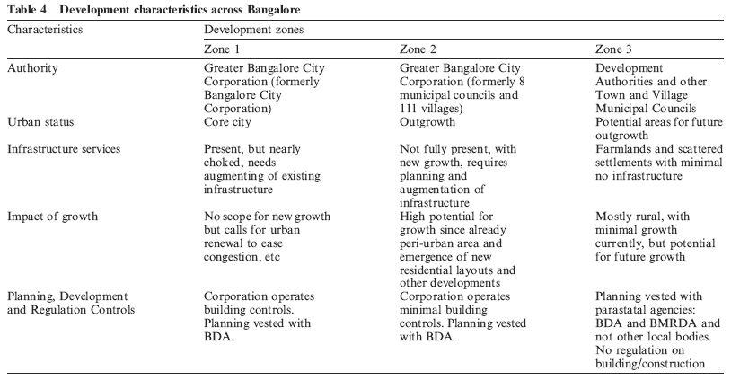
To understand the development characteristics of the Bangalore metropolitan area, it may help to distinguish three concentric zones zones which correspond closely with previous current local authority areas. The first zone would comprise the erstwhile city corporation area of 226 km2. The second zone would include the areas of the former 8 neighbouring municipal councils and 111 villages, which together form the peri-urban areas and are now incorporated into the Greater Bangalore City Corporation. The third zone would include other villages extending up to the Bangalore Metropolitan Area limits as proposed by Bangalore Development Authority. The development characteristics and agencies across these zones are summarised in Table 4 and depicted in Figure 1.
Traditionally, planning has been restricted to land use planning, being vested with BDA for the region under Bangalore urban agglomeration, and with Bangalore Metropolitan Region Development Authority (BMRDA) for the larger peripheral area comprising the rest of Bangalore Urban District(7). BDA obtains the land, develops it as residential layouts which eventually are handed over to the city corporation, often involving the extension of city limits. Land use plans are formalised through the Comprehensive Development Plans (CDP) prepared every 10 years. Accordingly, the last CDP, prepared in 1995 for the period up to 2011, was revised in 20052006 for the period up to 2015 and is currently awaiting approval. A key aspect of these CDPs are that they indicate the amount and location of land use allocated for various uses (like residential, commercial, industrial, etc.) as well as restricting development in specific areas demarcated as Green Belt and Valley Zones. However, another organisation similar to BDA, the Karnataka Industrial Area Development Board (KIADB), is responsible for development of industrial areas. These industrial estates are situated for the most part in the outskirts of the city and KIADB has powers under the law to take over agricultural lands for the purpose.
Generally, however, the regulation and enforcement of land use zoning regulations are dismal, leading to a large number of illegal developments and encroachments on public land problems which have led Karnataka State to constitute a legislative committee to look into irregularities in and around the city. In the particular case of growth occurring around outer industrial areas, the urban local bodies are generally unable to provide basic infrastructure and services, thus further aggravating inefficient utilisation of land and other natural resources. With such instances prevailing especially in the areas of the former Municipal Councils, the new Corporation faces a great challenge to deliver basic infrastructure and services.
On 3rd December 2005, the Ministry of Urban Development, Government of India, launched the Jawaharlal Nehru National Urban Renewal Mission (JNNURM). This countrywide programme addresses renewal of urban areas for 63 cities encompassing nearly 70% of total urban population, its primary aim being to link the revitalisation of urban infrastructure with a specific agenda of institutional reforms. Bangalore is one of the benefi- ciaries under this programme with an estimated outlay of US $ 1.7 billion over the next six years. The key mission of this programme is to support reforms- driven, fast track, planned development with focus on improving efficiency in urban infrastructure and service delivery mechanisms, through community participation and ensuring accountability of urban local bodies and parastatals towards citizens. JNNURM is made operational with two sub-missions:
In accordance with the JNNURM guidelines, the erstwhile Bangalore City Corporation prepared the City Development Strategy Plan (CDSP) for both UIG and BSUP (Bangalore Mahanagara Palike, 2006). The CDSP outlines only an investment plan and financial strategy for taking up various initiatives envisaged in the mission. Under BSUP, 218 declared slums in the former City Corporation limits would be taken up by KSCB for redevelopment. Further, there are 169 slums under the erstwhile City Corporation jurisdiction that remain undeclared, which would be redeveloped by the new Corporation. There are, in addition, 155 slums in the neighbouring former municipal council areas that would be redeveloped by the new Corporation and KSCB. However a draft community participation law has not been enacted and in Karnataka State most of the infrastructure projects and redevelopment plans have been administered by ULBs and parastatal agencies and not through community participation as envisioned by the mission. The result is a continuation of top-down rather than bottom-up modes of planning and delivering infrastructure and services. This calls for introspection on the implementation and achievement of the mission objectives. However, with various initiatives under JNNURM underway, it does offer hope, and perhaps promise, and in improving the essential urban infrastructure and services in city.
(9) Corporation refers to the recently noti- fied Greater Bangalore City Corporation unless otherwise stated.
(10) The urban agglomeration refers to the area formally administered by Bangalore City Corporation and the 8 councils.