Geography and environment |
Bangalore is located at  north
latitude and
north
latitude and  east longitude,
almost equidistant from both eastern
and western coast of the South Indian
peninsula, and is situated at an altitude
of 920 m above mean sea level.
The mean annual total rainfall is
about 880 mm with about 60 rainy
days a year over the last 10 years.
The summer temperature ranges from
east longitude,
almost equidistant from both eastern
and western coast of the South Indian
peninsula, and is situated at an altitude
of 920 m above mean sea level.
The mean annual total rainfall is
about 880 mm with about 60 rainy
days a year over the last 10 years.
The summer temperature ranges from
 , while the winter temperature
ranges from
, while the winter temperature
ranges from  Thus, Bangalore enjoys a salubrious
climate all round the year.
Thus, Bangalore enjoys a salubrious
climate all round the year.
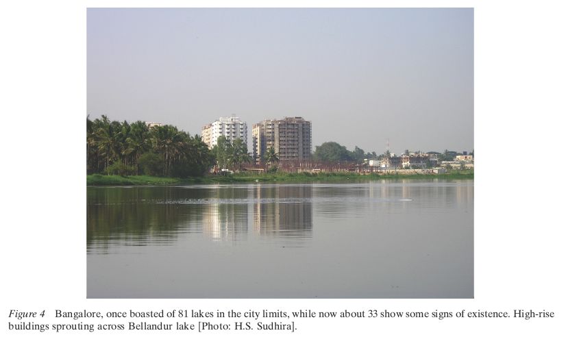
Bangalore is located over ridges delineating four watersheds, viz. Hebbal, Koramangala, Challaghatta and Vrishabhavathi watersheds. The undulating terrain in the region has facilitated creation of a large number of tanks providing for the traditional uses of irrigation, drinking, fishing and washing. Their creation is mainly attributed to the vision of Kempe Gowda and of the Wodeyar dynasty. This led to Bangalore having hundreds of such water bodies through the centuries. Even in early second half of 20th century, in 1961, the number of lakes and tanks in the city stood at 262. These, and open spaces generally, were seriously affected however with the enhanced demand for real estate and infrastructure consequent to urbanisation. Official figures for the current number of lakes and tanks vary from 117 to 81,(5) but recent satellite imagery (dated 2003) gives a different picture altogether, showing only 33 lakes visible,(6) out of which only about 18 are clearly delineated while another 15 show only faint signs of their former existence. With the citys unprecedented growth, the large number of public open spaces diminished over the years. Much of the loss in green cover is due to the rapid change in land use. As the city grew over space and time, inner areas got more crowded and congested. Initiatives to ease congestion on road networks have led to axing numerous road-side trees. Many lakes have been converted into residential layouts, bus stands, play grounds and stadiums, etc. (Figure 4). The built-up area in the metropolitan area was 16% of total in 2000 and is currently estimated to be around 2324%. The rest of the area is occupied by either agriculture lands, quarries or other vacant land.
In the aspect of nurturing flora and fauna, the situation in Bangalore is quite complex. With prominent green spaces like Lalbagh and Cubbon Park almost at the city centre and a few water bodies, such as Ulsoor, Sankey, Lalbagh, Yediyur and Madiwala, scattered across citys landscape, the remaining green spaces in the periphery harbour a great number of species. In a compilation of fauna present in and around Bangalore within a radius of 40 km from city centre (Karthikeyan, 1999), about 40 species of mammals, more than 340 species of birds, 38 species of reptiles, 16 species of amphibians, 41 species of fishes and 160 species of butterflies have been recorded. A new ant species, Dilobocondyla bangalorica, was discovered in Bangalore recently (Varghese, 2006). In another study, Sudha and Ravidranath (2000) have investigated the floral assemblage in different land-use categories and the changes in vegetation over Bangalore City. 164 species were identified in different residential areas, of which 149 were recorded within compounds and 87 were avenue trees. The rich diversity speaks for the volume of life still persisting in spite of rapid urban growth.
In recent times, the increase in vehicular traffic (see Section Urban Agenda addressing Infrastructure) has increased suspended particulate matter and other oxides of carbon, nitrogen and sulphur in the environment. Air pollution and the reduction in tree cover have induced the urban heat island effect resulting in variations in local temperature and sudden unanticipated showers during late afternoon.
(5) IDIP Report, prepared by STEM for KUIDFC, pp. 2, Chapter 8.
(6) Sudhira, 2006. Bangalore Lakes, Wayfaring Map. Available Online: http://www. wayfaring.com/maps/show/19613 Last Accessed: 14th Nov. 2006, 13:00 GMT.