 |
ANTS HABITAT MAPPING USING REMOTE SENSING AND GIS
Ramachandra T. V. and Ajay N. |
 |
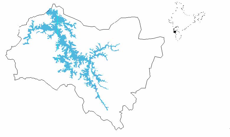
Study Area The Linganamakki catchment of the Sharavathi river basin is located between 13°43′24 N and 14°11′57 N, 74°40′58 E and 75°18′34 E in the central Western Ghats (Fig 1), with an elevation ranging between 80 and 1340 m. It spans Hosanagar, Sagar, and Thirthahalli taluks covering a total area of 2000 sq kms. Maximum rainfall occurs during the monsoon between June and September. (data collected from Drought Monitoring Cell, Bangalore). Figure 1. Location of Study area Large patches of undisturbed evergreen forests are present towards the western region of the study area (Fig 1) at Nagodi, Karni and Kodachadri wherein indicators of climax vegetation as Poeciloneuron indicum, Myristica dactyloides along with Dipterocarpus indicus, Aglaia anamallayana, Holigarna grahamii and Ficus nervosa are present. Poor regeneration of the deciduous species as Terminalia paniculata, Terminalia tomentosa, Terminalia bellarica, Lagerstroemia microcarpa, ascertained the presence of fire in the past. The shrub layer is dominated by Psychotria flavida, Pinanga dicksoni, Polyalthia fragrance, Strobilanthus species. A scrub savannah habitat with barren hilltops characterizes the 25km stretch from the reservoir on the western region to Tumri. Along the southeastern region, evergreen forests are found as small fragments along with deciduous species, covering Sharavathi state forest, Hilkunji, Nilvase and Kavaledurga. The extreme levels of encroachment and land utilization for various anthropogenic purposes were seen in the planes towards the eastern region. This suggests the uneven jagged topography in the southeast to have been the savior of these forests. Large areas of state forests towards the northeast have been converted to monoculture plantations of Acacia. The eastern region also had an unprecedented increase in the agricultural and wasteland area, built-up regions and tree savannahs. In the northeastern region the invasive weed Euphatorium odoratum dominated, indicating extreme degree of disturbance. Anthropogenic activities in recent times has resulted in large scale fragmentation, creating a mosaic of land cover patterns of agricultural fields, monocultures of acacia, eucalyptus, rubber, arecanut, pine, casuarina and cashew along with evergreen forests, moist deciduous and scrub jungles in the river basin. |

| E-mail | Sahyadri | ENVIS | GRASS | Energy | CES | CST | CiSTUP | IISc | E-mail |