A 2-m state-of-the-art telescope (National Large Solar Telescope - NLST) aimed at understanding the fundamental processes taking place on the Sun has been proposed at Pangong lake site at Merak due to the optimum atmospheric properties (the number of sunshine hours, sky brightness and good atmospheric window enabling observations over long periods). This unique facility with the innovative design and backend instruments will enable observations with an unprecedented high spatial resolution that will provide crucial information on the nature of magnetic fields in the solar atmosphere and also night-time astronomy. This being a multi-purpose telescope, with state of the art post-focus instruments will permit Indian scientists to carry out cutting edge research towards understanding the fundamental processes taking place on the Sun.
The proposed NLST would involve the construction and operation of a modified reflecting Gregorian-type telescope that would deliver images of small part of the sun (300” ×300”) onto instrument stations mounted on the telescope and on a rotating platform located below the telescope. The facilities would include: the observatory facility, which includes the telescope (kept at a height of nearly 26 m), its pier, and the rotating instrument platform, the telescope enclosure, the telescope building with a diameter of approximately 15 m and an aluminizing chamber at a separate location sufficiently far off from the site.
Constitution of the team: The current study was undertaken by a multidisciplinary team of scientists and engineers that comprised of ecologists, environmental engineers, , GIS and remote sensing experts, botanists, zoologists, soil and water scientists, and wildlife experts. The team visited the site and carried out field work during 25-28th September 2010.
Aspects/Facets of the study:
Environmental Impact Assessment of the National Large Solar Telescope Project and its ecological impact in Merak area. This involves land use analysis and investigations of flora and fauna
Landscape: Land use, Land cover analyses; Biodiversity; Aquatic ecosystem: Soil, water and sediment characterization, impacts of the proposed work, proposed environment management plan to mitigate the likely impacts
Study Area: The proposed location for commissioning a 2 m state-of-the-art telescope class telescope (National Large Solar Telescope (NLST) is at Merak, close to the Pangong Tso Lake and inside the Changthang Wildlife Sanctuary. Changthang Wildlife Sanctuary is a habitat for endemic, endangered species, vulnerable, and near threatened species. The area is of adequate ecological, faunal, floral, geomorphological and natural significance, and also link one protected area with another. The area of Pangong Tso Wetland is one of the Wet-site of the Changthang Wildlife Sanctuary. The area of 4000 Sq.Kms stands notified as Wildlife Sanetnary since 19-03-1987. The same wet-site is protected under the overview of J&K Wildlife Protection Act 1978.
Methods:
- Land use analysis: Remote sensing data along with collateral data
- Ecology and Biodiversity: Field visit, consultation with the local forest department officials and published literature
- Documentation of the existing flora in the proposed corridor
- Documentation of animal paths (bird migratory paths, if any)
- Documentation of endemic species
- Assessing the Environmental Impacts
- Arriving at environmental management plan to achieve the least disturbance to the existing flora and fauna
- Development of Environment Management Plan: This is based on the understanding of ecological and environmental impacts (if any) – quantification was done based on the detailed field visit.
Significant Findings:
- The Pangong Tso wetland (at elevation of 4258 m), is the longest lake in Ladakh, with about 50 km stretch within Indian territory and over 100 km long stretch in the Tibetan plateau of neighbouring China. It is fed by glacial waters and is well known for its deep blue colour. Over the years, the outflows got blocked and the lake became mildly brackish. Therefore, except for the locations of fresh glacial waters, the lake does support marine life evident from under-water plants and algae. The lake is said to be in a seismically safe zone. It runs between two mountain ranges in the NW to SE direction which steadily widen towards south of south-east, before bending eastward into China
- The Pangong Tso Wetland is home to a wide range of fauna ranging from migratory birds to mammals of various species. The black-necked Siberian crane, bar-headed geese and waterfowl are recorded at the lake. Many cranes sp. (i.e. species) such as red crowned crane, bar headed goose and the high souring raptors cross high ranges to enter India and finally leave towards Africa during the winter. The Siberian birds do also enter the country through the north eastern Himalayan ranges and traverses through the Western Ghats and southern parts of India before leading to Africa.
- During the construction phase, there is likelihood of local disturbance on the silent and pristine ecosystem. Movement of vehicles and the transfer of raw materials and consequent noise and vibration would disrupt the local fauna habitat. The salinity of the water is around 10, 000 mg/l. Special care should be taken for the metals like Fe and Cu, which have ample chances of a very high corrosion.
- Earlier studies indicate of increasing water levels and there is gradual submersion of some elevated regions along the beaches of the lake. The proposed site (incursions into the lake) has mixed origins which are parts of sedimentary deposits. These necessitate appropriate structure through geotechnical investigations.
- During the operation of the telescope, highly focused and concentrated reflected light attract the birds. The very reflection and glare might disturb the birds passing by the region. This excessive or obtrusive artificial light which hinders the movement of organisms is referred as photo pollution or luminous pollution. This reflected light from the mirror can confuse animal navigation and cause physiological harm. Birds have tendency to get attracted to the intense light energy, and hit the mirror which might even damage the mirror.
- The field investigations and subsequent synthesis of field data indicate that the proposed project has minimal impact on the environment and appropriate mitigation measures would help in addressing these impacts.
Environment Management Plan:
- Suppression of dust during the movement of vehicles –operation phase
- Construction work and movement of vehicles only during the day time so that the fauna are not affected during the night.
At site:
- Shadow plate covering the primary mirror protects it from the vision of birds.
- The mitigation measure involves change in angle to 30 degrees at the heat stop so that the reflection from the heat stop is diffused and directed towards a far off point in the ground and hence flying bird/birds are insulated from any reflections.
- Use of low energy ultrasound transmitters to ward off the birds around the telescope in an area of around half an acre.
- Planting of native species of flora would aid as heat sinks
- Setting up science centre and primary health centre for the employees and local public (part of the social commitment)
Merak near Pangong lake is the most suitable site for commissioning and operation of National Large Solar Telescope. The activities will involve minimal environmental impacts. Setting up of NLST would boost the region as it would provide employment opportunities, and associate benefits (like medical facilities, education, etc.) to the local people. This also gives visibility to the region in the global perspective and might prevent further land encroachments. Bird’s death is reported in migratory path sue to Sky scrapers which are constantly lit (high intensity illumination).
Reports reveal that about five million birds, representing about 250 species (most of them are nocturnal migrants), fly through Chicago twice a year get confused with the night time lights of high rise buildings. These birds either crash into high intensity reflection of these buildings or get disoriented causing them to circle around and around, finally setting exhausted in a street tree or bush. These birds tend to fly into glass windows as they fly towards a reflection. Mitigation measures adopted by local residents are to dim or turn off decorative lighting late at night and to minimize the use of bright interior lights during migration season.
In this context, considering the proposed building height of NLST building and implementation of the suggested mitigation measures (- Shadow plate covering the primary mirror protects it from the vision of birds; change in angle to 30 degrees at the heat stop so that the reflection from the heat stop is diffused and directed towards a far off point in the ground and hence flying bird/birds are insulated from any reflections and use of low energy ultrasound transmitters to ward off the birds around the telescope in an area of around half an acre) would minimise the impact on birds.
II Project Description
Description of project rationale: A 2-m state-of-the-art multi-purpose National Large Solar Telescope (NLST) at Merak with state of the art post-focus instruments has been proposed to carry out cutting edge research with an aim to understand the fundamental processes taking place on the Sun. It’s innovative design and backend instruments will enable observations with an unprecedented high spatial resolution that will provide crucial information on the nature of magnetic fields in the solar atmosphere. This would be the largest solar telescope in the world and fills the longitude gap between Japan and Europe. NLST will be a telescope, which will be equipped. This would represent a continuation and extension of the tradition of solar studies established at Kodaikanal more than a century ago.
The selection of a site with optimum atmospheric properties, such as the number of sunshine hours and good “seeing” over long periods are critical to the successful implementation of NLST. In this regard site characterization has been conducted at locations such as Hanle, Merak and Devasthal. The data obtained so far suggest that the Pangong lake site at Merak has excellent “seeing” conditions suited for a 2-m class solar telescope.
Site survey, selection criteria and reasons for selecting the proposed site at Pangong Lake: Critical to the successful implementation of NLST is the selection of a site with optimum atmospheric properties. Absence of clouds is one of the primary criteria. Another is the presence of good seeing over long periods of time with clear skies. The diffraction limit of a 2 meter solar telescope at 500 nanometers is 0.06 arc sec which corresponds to about 40 km on the solar surface. With the use of adaptive optics, features on the sun can be resolved nearly up to the above limit provided the atmospheric ‘seeing’ conditions of the site where the telescope is located are very good, say in the range of 1” or better for significant periods of time. This forms a major requirement for the site. Reconnaissance surveys were carried out in Ladakh. Hanle was chosen for evaluation due to the advantage of logistics of already existing stellar observatory there.
Among the lake sites, the Pangong lake appeared more promising than Tso Morari or other major lakes in Ladakh, due to the following advantages; its 30 km stretch within India, the several land incursions into the lake, the almost east – west elongation, the wind ducting from east to west, and the large flat land at the southern shore allowing good access to the southern declination, necessary for solar observations at this latitude of about 34 degree north. The essential parameters monitored were total annual sunshine hours, sky brightness, atmospheric seeing at various heights of up to tens of meters above ground, micro thermal conditions, meteorological parameters such as precipitation, wind speed, wind direction, humidity, irradiance, temperature range, aerosol distribution at site and etc. Regular observations of seeing and other related parameters were carried out by IIA at Hanle for over two years, at Merak for over one year.
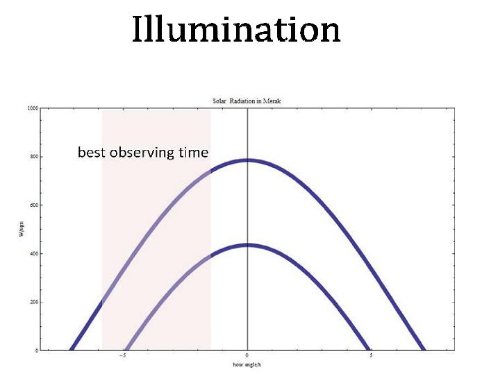
The Pangong lake site at Merak appears to be very promising - it provides excellent spells of continuous sub arc second periods of seeing (Figure 1). The wind speeds of a few meters per second for most part of days help to stabilize the thermals. The total annual sunshine hour is comparable to Hanle, being in the range of 1700 hours. However the afternoons in Hanle have periods of strong winds.

Figure 1: Intensities of solar radiations at Merak
Need for a 2 m Telescope: A 2-m class telescope with a sufficiently large aperture, is required to observe processes occurring on spatial scales of tens of kilometers (as crucial physical processes like vortex flows, dissipation of magnetic fields and the generation of MHD waves can occur efficiently on length scales even as small as 10 km). Telescope operating at its diffraction limit is required in order to resolve structures with sub-arc sec resolution in the solar atmosphere as well as to carry out spectropolarimetry. Good angular resolution with a high photon throughput is necessary for spectropolarimetric observations to accurately measure vector magnetic fields in the solar atmosphere with a good signal to noise ratio. In order to resolve structures with sub-arc sec resolution in the solar atmosphere as well as to carry out spectropolarimetry, a sufficiently large aperture telescope is required. Resolving structures observationally is of utmost importance to study and improve our understanding of the different physical processes involved. This helps in understanding the interaction of magnetic fields with plasma for interpreting various processes in the atmosphere of the Sun. Unfortunately apertures needed to resolve solar features to this level at visible wavelengths limit even the largest current solar telescopes. Presently, the best spatial resolution that the existing generation of solar telescopes can attain during moments of good seeing and using adaptive optics is limited to about 0.13 arc sec corresponding to nearly 90 kms on Sun. NLST would provide a superior platform for performing high quality solar research and aid as an unique research tool for several talented solar astronomers and is expected to bring in enormous growth in scientific development for the local region and the state. This would demand great technological challenges, give several spin-offs both direct and indirect to the country.
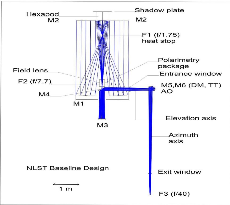
NLST is a 3-mirror, Gregorian on-axis telescope with a 2-m aperture primary mirror and a final f/40 focal ratio. NLST has a high throughput, which is highly desirable for polarimetry and speckle interferometry. The telescope has a high-order adaptive optics (AO) system to ensure diffraction limited performance. A 2-m parabolic primary mirror M1 (f/1.75) forms an image of the solar disk with a diameter of 33 mm at the prime focus F1. Here a cooled heat stop rejects and dissipates all the energy which does not pass through the stop. The primary mirror is cooled from below to keep it close to the ambient temperature. A beam, providing total field of view (FOV), passes through the centre hole with 3.4 mm diameter. An elliptical mirror M2 creates f/7.7 beam and forms a secondary focus F2 at a distance of ~600mm in front of M1 and about 200 mm above the elevation axis. Here a FOV of 200 arc sec corresponds to a scale of 15 mm. The modulation and calibration of the polarimetric package is kept here to exploit the symmetry property. A weak negative field lens is also situated here (see Fig. 2). The F2 image is sent to another elliptical mirror M3 which changes the f-ratio to f/40 in the beam that produces a final image at F3 where we have the desired image scale of 2.5 arc sec mm-1. Additional specifications are listed in Table 1.
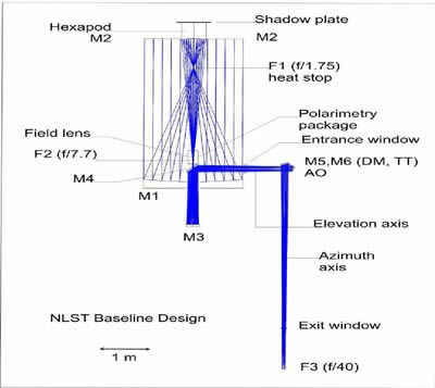
Figure 2: Optical layout of NLST
Table 1: Optical Specifications
| Aperture ( primary mirror M1 ) |
: 2 metre |
| Focal length |
: 4 metre |
| Optical configuration |
: 3 mirror, Gregorian on axis |
| Aberration free Field of view |
: f / 40 |
| Image scale |
: 2.58 arc sec mm-1 |
| Optical quality |
: 80 % of energy to be within circle of 0.1 arc sec or less over the entire field of view of nearly
3 arc min diameter at 5000 Å. |
| Wavelength of operation |
: 3800 Å to 2.5 microns |
| Polarization accuracy |
: better than 1 part in 10,000 |
| Scattered light level within telescope |
: < 1 % |
| Active and Adaptive optics |
: to realize near diffraction limited performance;
Strehl ratio >0.5 within Isoplanatic patch |
| Spatial resolution |
: < 0.1 arcsec at 5000 Å. |
M4 is a flat mirror with a central hole that reflects the beam into the elevation axis. The mirror group M5/M6 reflects the beam into the azimuth axis which in our design is by the side of the primary mirror. By means of the field lens in F2, the pupil is imaged on M6 which can serve as the tip tilt mirror of the AO. M5 is a deformable mirror. F3 is about 6200 mm below the elevation axis which allows for convenient access of the focus points in the building. A mechanical turntable behind the telescope moves the whole post focus assembly which compensates for the rotation of the image due to the alt-azimuth telescope system. NLST has a mounting which is optimized for natural air flush in order to minimize mirror seeing. Heat near the primary focus is taken out of the system with a heat stop.
NLST is housed in a building which is optimized aerodynamically in order to minimize turbulence above the telescope. The telescope has an open design with a simple retractable dome that will cover the telescope during the period when there are no observations.
Basic principles:
Solar constant outside atmosphere: 1360 W/m2
Solar radiation at surface is given by the following equation:

Precautions have been taken to mitigate the likely impacts of reflection from the mirror and likely impacts on birds. These include:
- Shadow plate covering the primary mirror protects it from the vision of birds.
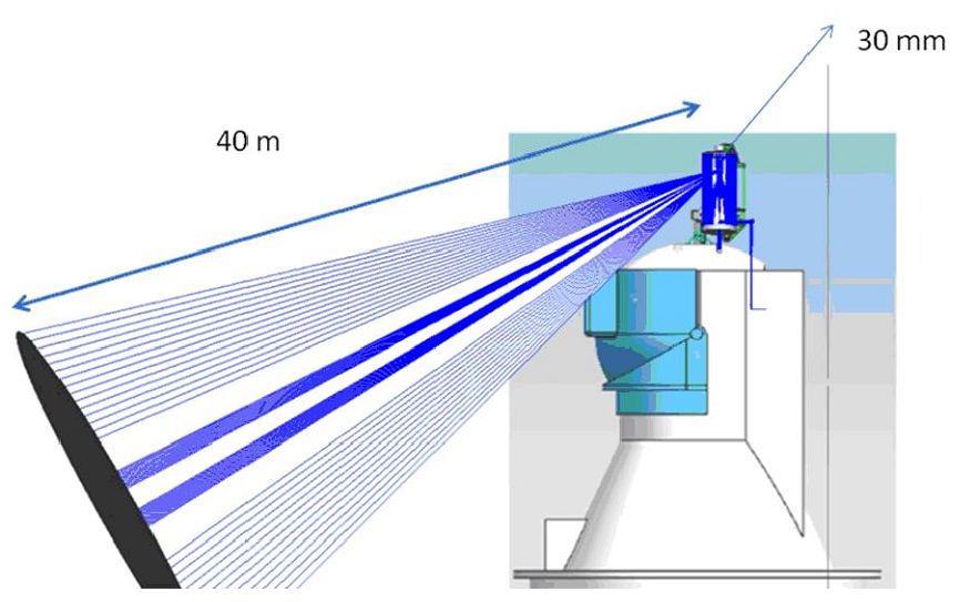
- Change in angle to 30 degrees at the heat stop so that the reflection from the heat stop is diffused and directed towards a far off point in the ground and hence flying bird/birds are insulated from any reflections (figure 3).
- Use of low energy ultrasound transmitters to ward off the birds around the telescope in an area of around half an acre.

Figure 3: Beam Geometry
The Merak site at Pangong lake has sky conditions which are comparable to that of the Big Bear Solar Observatory lake site, combined with the advantages of the high altitude desert. It certainly appears to be well suited for locating a two meter or even a larger solar telescope for optical and near infra red observations. The following major criteria were used for preliminary selection:
- Annual number of clear sunshine hours (in the range of 2000),
- Significant number of 1 hour spells with median Fried parameter (r0) of 7 cm or better and 30 min spells of r0 better than 10 cm,
- High altitude for excellent transparency & dry conditions for NIR observations, &
- Lake sites with winds of 4 to 8 mps, as they are known to be good for day skies.
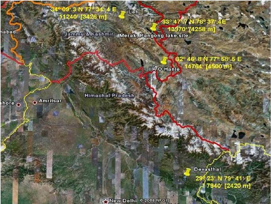
Consideration and evaluation of project alternatives: The exploratory surveys were carried out in Hanle, Devasthal and Pangong Tso (Figure 4). The mountain desert conditions of Ladakh provide good number of sunshine hours with minimal precipitation and have the additional advantages of high altitude desert, such as excellent transparency and low humidity. Therefore, Hanle, at an altitude of 4500 m in the Great Himalayan range in Ladakh, with demonstrated good conditions for astronomical seeing for the night sky, having median of 1.07 arc sec, which was selected through a survey of the region during 1995-2000, was chosen as one of the sites for evaluation.
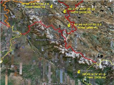
Figure 4: Locations of the three probable sites, Hanle, Devasthal, & Merak
Similarly, Devasthal, at an altitude of 2540 m in the Shivalik Hills of the Central Himalayan range and has been shown, through a survey during 1980-1990, to have good night sky conditions with medians of 1.1 to 1.4 arc sec (Sagar et al 2000), was chosen for detailed evaluation since it provided an alternative topographical environment in the Himalayan range. Besides, these two sites would have the advantage of the logistics available in an existing astronomical observatory.
Several lakes in Ladakh were examined for prospective sites. Tso Morari, Pangong Tso, Tso Kar, and Twin lake, in the altitude range of 4200 to 5000 m, were considered. The Pangong Tso lake, with a long stretch of about 50 km, was readily recognized to be the most promising lake site for detailed evaluation. The desirable land protrusion into the lake, the steady wind flowing over the water body for most part of the day, and the clear access to the southern sky, were found to be most favourable at a site along the shore near village Merak. This site was selected for detailed evaluation.
Description of the sites selected: Three sites Hanle, Devasthal and Merak were identified for the detailed investigations.
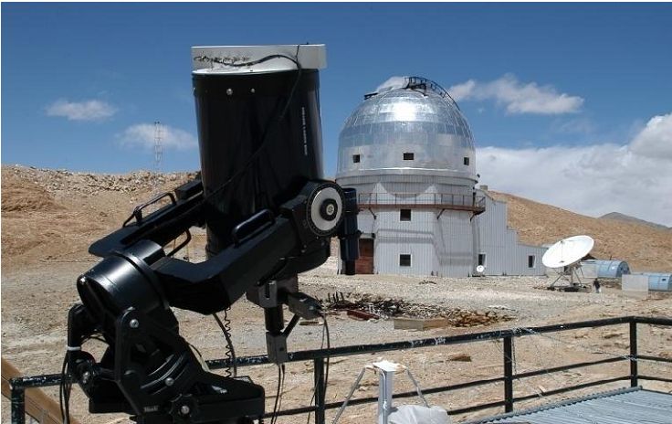
Hanle: This site was selected to be most prospective for night time astronomy, based on a detailed study of meteorological data, satellite imagery, and site reconnaissance trips to six high-altitude sites in the Great Himalayan Ranges. Site characterization starting 1995 proved that Hanle in the high altitude cold desert of south eastern Ladakh is among the best high altitude sites in the world for astronomical observations. A 2 m optical telescope, with remote operational facility from near Bangalore, started functioning in the year 2000 (Figure 5). A site adjoining the 2 m optical telescope, at 32° 46' 47" N, 78° 57' 50" E, and at an altitude of 4486 m, was selected for detailed study of the day time conditions.
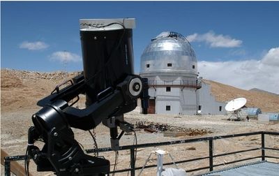
Figure 5: NSO S-DIMM at Hanle
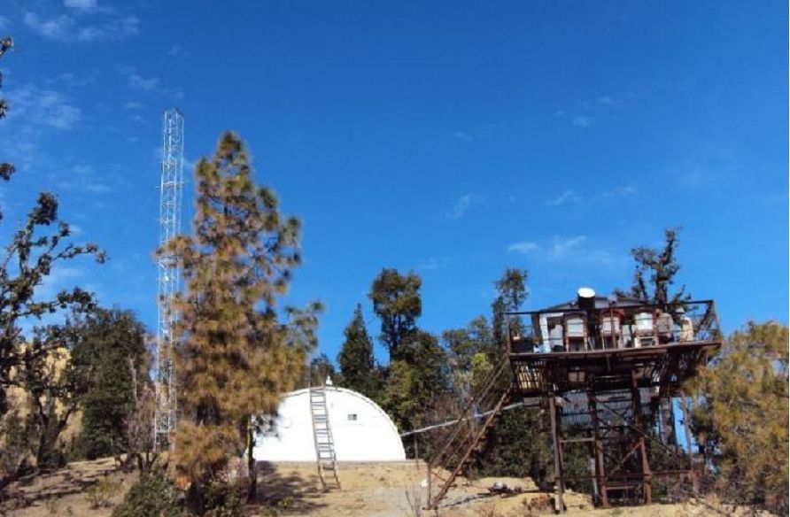
Devasthal: After a preliminary survey, carried out during 1982-91 and Devasthal turned out to be the choice in terms of the prevailing night time seeing, meteorological conditions, and also the logistics involved. A 1.3 m optical telescope has become operational in 2010, while a 3.6 m optical telescope, in collaboration with TIFR, Mumbai, is in an advanced stage of procurement. Both the telescopes are to be used for night time astronomy.
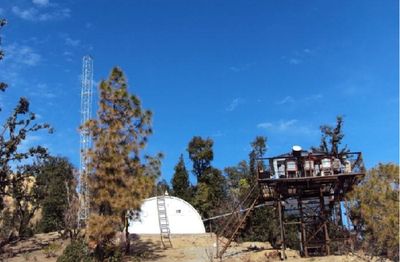
Figure 6. Devasthal site with instruments on towers and the observation hut.
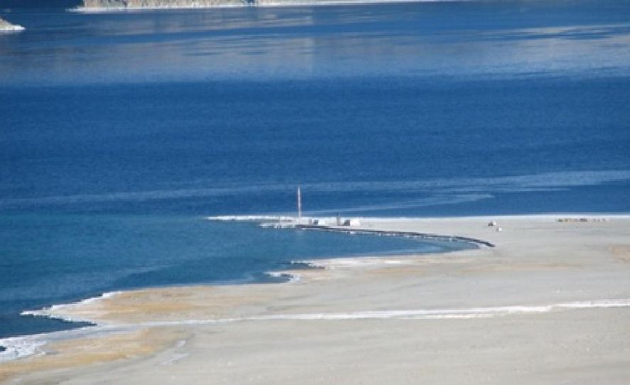
Merak: The picturesque Pangong lake, at an elevation of 4258 m, is well known for the deep blue colour of its water body. It is the longest lake in Ladakh, with about 50 km stretch within Indian territory and over 100 km long stretch in the Tibetan plateau of neighbouring China. Fed by glacial waters, the lake once drained into the Tangshe river. Over the years, the outflows got blocked and the lake became mildly brackish. Therefore, except for the locations of fresh glacial waters, the lake does support marine life. The lake is said to be in a seismically safe zone. It runs between two mountain ranges in the NW to SE direction which steadily widen towards south of south-east, before bending eastward into China
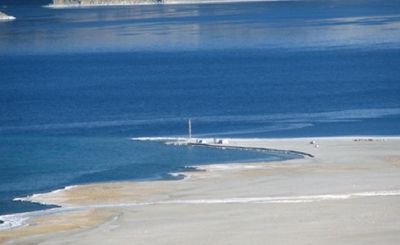
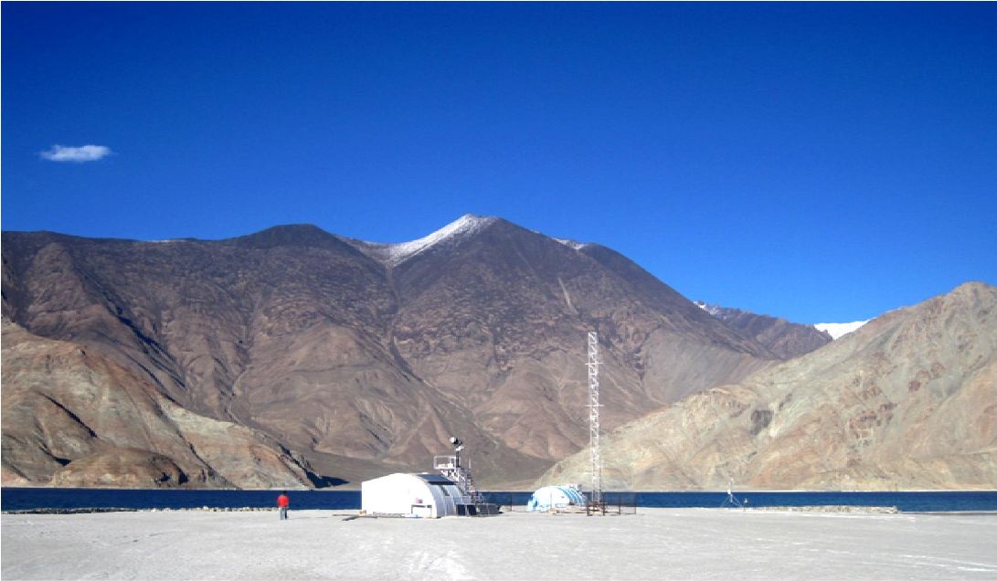
Figure 7: The Merak site with the lake. Cluster of towers & instruments, and the observing hut are noticeable
The western shore of the lake has two villages, Spangmik and Merak. Following a survey of the entire shore, the land protrusion near Merak at 33° 47' 42" N, 78° 37' 08" E, was selected for implementing NLST. The prevailing wind is channeled over the water body for most part of the day, at a steady speed of a few mps, and this was readily recognized to be a major advantage of the site. The lake is well connected by road up to its starting point at Lukung, which is five hours drive from Leh via Chang La pass. A motorable mud road further connects Spangmik, Merak, and Chushul.
Methods used to identify, predict and assess impacts
- Land use analysis: Remote sensing data along with collateral data
- Ecology and Biodiversity: Field visit, consultation with the local forest department officials and published literature
- Documentation of the existing flora in the proposed corridor
- Documentation of animal paths (bird migratory paths, if any)
- Documentation of endemic species
- Assessing the Environmental Impacts
- Arriving at environmental management plan to achieve the least disturbance to the existing flora and fauna
- Development of Environment Management Plan: This is based on the understanding of ecological and environmental impacts (if any) – quantification would be done based on detailed field visit.
III Description of the Baseline Environment
The land protrusion near Merak at 33° 47' 42" N, 78° 37' 08" E, close to the Pangong Tso Lake and inside the Changthang Wildlife Sanctuary was selected for commissioning a 2 m state-of-the-art telescope (National Large Solar Telescope - NLST). Changthang Wildlife Sanctuary is a habitat for endemic, endangered species, vulnerable, and near threatened species. The area is of adequate ecological, faunal, floral, geomorphological and natural significance, and also link one protected area with another. The area of Pangong Tso Wetland is one of the Wet-site of the Changthang Wildlife Sanctuary. The area of 4000 Sq.Kms stands notified as Wildlife Sanctuary since 19-03-1987. The same wet-site is protected under the overview of J&K Wildlife Protection Act 1978. its 30 km stretch within India, the several land incursions into the lake, the almost east – west elongation, the wind ducting from east to west, and the large flat land at the southern shore allowing good access to the southern declination, necessary for solar observations at this latitude of about 34 degree north. The essential parameters monitored were total annual sunshine hours, sky brightness, atmospheric seeing at various heights of up to tens of meters above ground, micro thermal conditions, meteorological parameters such as precipitation, wind speed, wind direction, humidity, irradiance, temperature range, aerosol distribution at site and etc. The next sections will discuss of Himalaya (geological aspects, evolution), origin of lake as the proposed site is land incursion into the lake
Himalaya: Description
Being the highest mountain range in the world the Himalayas extends along the northern frontiers of Pakistan, India, Nepal, Bhutan, and Burma. Its origin was geologically driven as a result of the collision of the Indian subcontinent with Asia. This process of plate tectonics is ongoing, and the gradual northward drift of the Indian subcontinent still causes earthquakes. Lesser mountain ranges proceed southward from the main body of the Himalayas at both the eastern and western ends. The Himalayan system spanning about 2,400 kilometers in length and varying in width from 240 to 330 kilometers, is made up of three parallel ranges i.e. the Greater Himalayas, the Lesser Himalayas, and the Outer Himalayas and are sometimes collectively called the Great Himalayan Range.
The Greater Himalayas, or northern range, average approximately 6,000 meters in height and contain the three highest mountains on earth: Mount Everest (8,796 meters) on the China-Nepal border; K2 (8,611 meters, also known as Mount Godwin-Austen, and in China as Qogir Feng) in an area claimed by India, Pakistan, and China; and Kanchenjunga (8,598 meters) on the India-Nepal border. Many major mountains are located entirely within India, such as Nanda Devi (7,817 meters) in the state of Uttar Pradesh. The snow line averages 4,500 to 6,000 meters on the southern side of the Greater Himalayas and 5,500 to 6,000 on the northern side. Because of climatic conditions, the snow line in the eastern Himalayas averages 4,300 meters, while in the western Himalayas it averages 5,800 meters.
The Lesser Himalayas range from 1,500 to 5,000 meters in height and are located in northwestern India in the states of Himachal Pradesh and Uttar Pradesh, in north-central India in the state of Sikkim, and in northeastern India in the state of Arunachal Pradesh. Shimla (Simla) and Darjiling (Darjeeling) are the hill stations located in the Lesser Himalayas. It is in this transitional vegetation zone that the contrasts between the bare southern slopes and the forested northern slopes become most noticeable. The Outer or Southern Himalayas, averaging 900 to 1,200 meters in elevation, lie between the Lesser Himalayas and the Indo-Gangetic Plain. In Himachal Pradesh and Uttar Pradesh, this southernmost range is often referred to as the Siwalik Hills. The northernmost range, known as the Trans-Himalaya and is located entirely on the Qinghai-Xizang Plateau, north of the great west-to-east trending valley of the Yarlung Zangbo river. Although the Trans-Himalaya Range is divided from the Great Himalayan Range for most of its length, it merges with the Great Himalayan Range in the western section as the “Karakoram Range” where India, Pakistan, and China congregate. The southern slopes of each of the Himalayan ranges are too steep to accumulate snow or support much tree life; the northern slopes generally are forested below the snow line. Between the ranges are extensive high plateaus, deep gorges, and fertile valleys, such as the vales of Kashmir and Kulu. The Himalayas serve a very important purpose as they provide a physical screen within which the monsoon system operates and are the source of the great river systems that water the alluvial plains below. As a result of erosion, the rivers coming from the mountains carry enormous quantities of silt that enrich the plains. The area of northeastern India adjacent to Burma and Bangladesh consists of numerous hill tracts, averaging between 1,000 and 2,000 meters in elevation, that are not associated with the eastern part of the Himalayas in Arunachal Pradesh. The Naga Hills, rising to heights of more than 3,000 meters, form the watershed between India and Burma. The Mizo Hills are the southern part of the northeastern ranges in India. The Garo, Khasi, and Jaintia hills are centered in the state of Meghalaya and, isolated from the northeastern ranges, divide the Assam Valley from Bangladesh to the south and west.
Evolution of Himalaya:
It is now widely accepted that the collision between the Indian Plate and the collage of previously sutured micro-continental plates of Central Asia occurred during the mid to late Eocene, at approximately 50-45 Ma (Million yrs. Ago) (Alleigre et al., 1984; Searle et al., I987). The timing of terminal collision of the two plates is deduced from (i) the ending of marine sedimentation in the Indus Suture Zone (ISZ), (ii) the beginning of continental molasse sedimentation along the suture zone, (iii) the ending of Andean-type calc-alkaline magmatism along the Trans-Himalayan (Ladakh-Kohistan-Gangdese) batholith and (iv) the initiation of the major collision-related thrust systems in the Himalayan Ranges. Palaeo-magnetic data indicate that over 2000-2500 km of southern (Neo) Tethys separated 55 Ma (Klootwijk, I979) and terminal collision at about 40 Ma (Molnar & Tapponnier 1975; Klootwijk & Radhakrishnamurthy, 198I). The northward relative motion of the Indian Plate decreased threefold at 40 Ma from average rates of 14.9 + 4.5 cm/a to 5.2 + 0.8 cm/a (Pierce, 1978). Seafloor spreading rates in the Indian Ocean also decreased drastically at anomaly 22 (given in the fig. below), which corresponds in time to ca. 50 Ma (Sclater & Fisher 1974; Johnson et al. 1976). Major directional shifts in the relative motion of the Indian Plate at anomalies 22 and 21 (given in the fig. below) (50-48 Ma) are also thought to indicate the onset of collision (Patriat & Achache, 1984). Another major shift occurred at anomaly 13 (36 Ma) after which India resumed stable northwards convergence with a constant rate of 5 cm a-' (Patriat & Achache, I984).
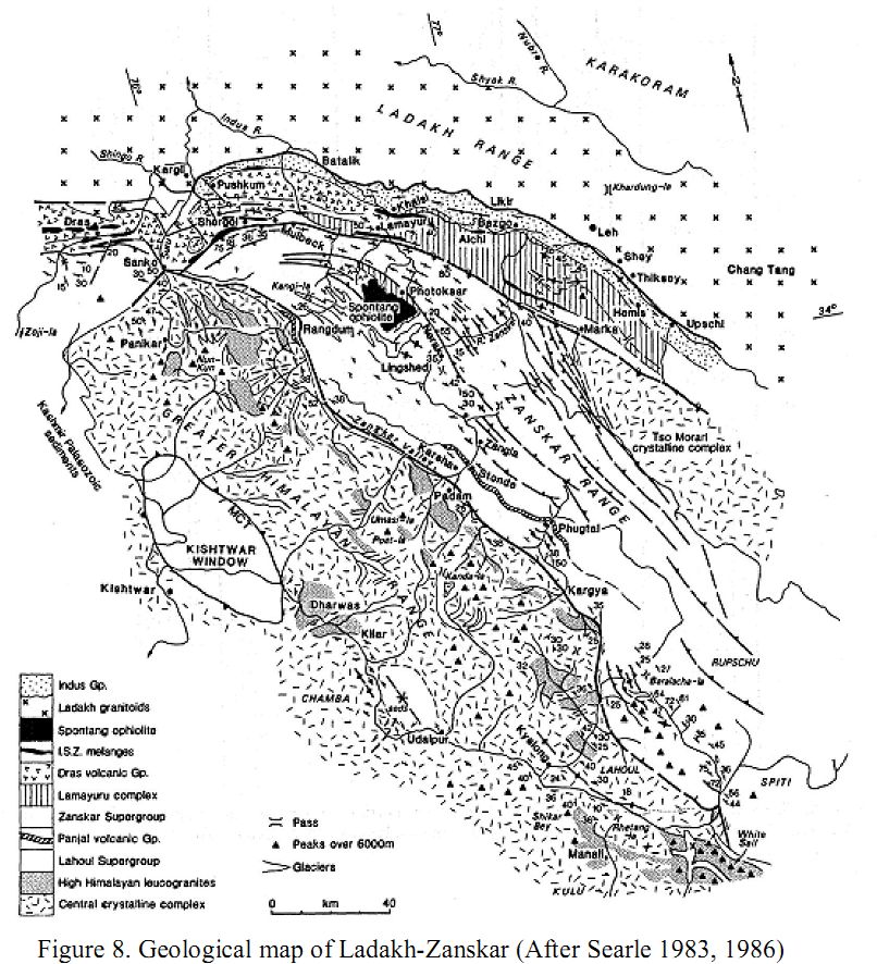
The post-collision crustal shortening in the Indian Plate can only be deduced from the restoration of balanced cross sections across the Himalaya. It is widely recognized that in general terms, southward-propagating thrust stacking had occurred across the Himalaya since the mid-Eocene collision and suturing (Molnar 1984; Mattauer 1986; Searle et al., 1987). The climax of crustal shortening and thrust stacking occurred during the mid-Tertiary in the High Himalaya and Zanskar Ranges, with thrusts propagating southwestwards from the Main Central Thrust (MCT) system to the Lesser Himalaya and the late Tertiary Main Boundary Thrust (MBT) system (Figure 8). The youngest thrusts occur along the southern boundary of the Himalaya, in the Siwalik molasse deposits of the Indian foreland basin, where the Main Frontal Thrust (MFT) terminates at tip lines below the Indo-Gangetic plains. Four major tectonic zones constitute the Ladakh-Zanskar Himalaya. These are, from north to south, the Ladakh (Transhimalayan) batholith, the Indus Suture Zone, the Tibetan-Tethys (Zanskar shelf) Zone, and the High Himalaya. A generalized geological map depicting these zones is shown in figure. 2. Figure 3 shows a late Cretaceous and Tertiary time chart for the Ladakh-Zanskar Himalaya (after Searle 1983, 1986) updated with all radiometric ages and stratigraphic time spans for the four tectonic zones.
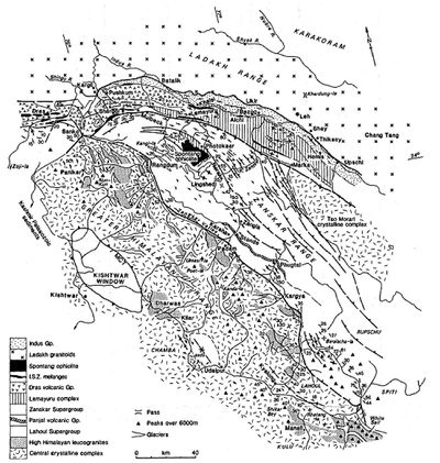
Figure 8. Geological map of Ladakh-Zanskar (After Searle 1983, 1986)
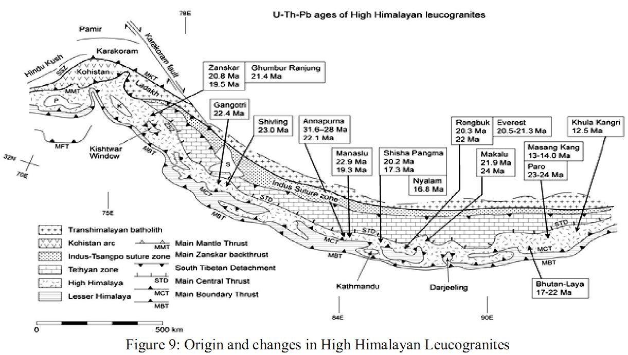
Ladakh Batholith: Batholiths are large emplacement of igneous intrusive (also called plutonic) rock that forms from cooled magma deep in the earth's crust. Batholiths are almost always made mostly of felsic or intermediate rock-types, such as granite, quartz monzonite, or diorite. The Ladakh batholith, a part of the 2000 km long Transhimalayan batholith, is situated to the north of the ISZ (Indus Srture Zone) in the Ladakh Ranges (figure 9). The Transhimalayan belt continues westward to include the Kohistan batholith in northern Pakistan (Petterson & Windley, I985) and eastward to include the Gangdese batholith in south Tibet (Alleigre et al., 1984; Tapponnier et al. 1981). The Ladakh batholith ranges in composition from olivine-norite (types of rocks) to leucogranites with grandiorites dominating (Thakur, 1981; Honegger et al., 1982). Olivine-orthopyroxene-bearing norites, gabbros, diorites, granodiorites, granites and leucogranites are all represented and collectively represent a continental, subduction-related batholith (Honegger et al. i982). The presence of granitic gneisses and meta-sedimentary sequences in the Ladakh Range provides evidence for the existence of precursory continental crust (Honegger & Raz, 1985). Furthermore, a substantial component of inherited lead in zircons extracted from samples of the batholith implies involvement of continental crust during ‘petrogenesis (Scharer et al., 1984).
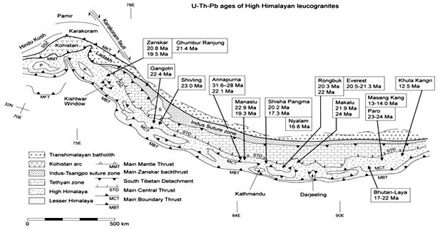
Figure 9: Origin and changes in High Himalayan Leucogranites
Initial 87Sr/86Sr ratios of around 0.704 (Scharer et al., 1984) and 0.705 (Honegger et al., 1982) are un-enriched, inferring a primary mantle that is a derivation of the magmas. The amount of isotopic enrichment due to the envisaged crustal component remains to be quantified. Available geo-chronological determinations indicate that the Ladakh batholith is composite and dominated by pre-collisional magmatic events. U-Pb zircon ages of 103+3 Ma (Honegger et al., 1982) and 101+2 Ma (Scharer et alt., 1984) from samples collected near Kargil refer to important mid-Cretaceous magmatism. A second U-Pb determination of monazite/allanite from a biotite-granite near Leh gave an age of 60.7+0.4 Ma, whereas a Rb-Sr isochron age of 73+2.4 Ma (Scharer et at. 1984) and a 39Ar/40Ar age of 82 + 6 Ma (Sckirer & Allbgre, 1982) may indicate a continuity of magmatic activity for some 40 Ma, finally terminating with continent-continent collision (figure 10). Likewise, a span of K-Ar mineral ages of 50-40 Ma is considered to reflect a cooling period associated with uplift.
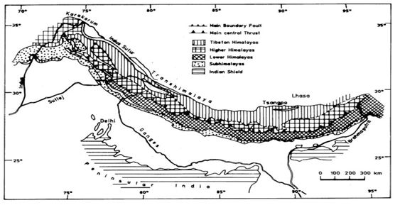
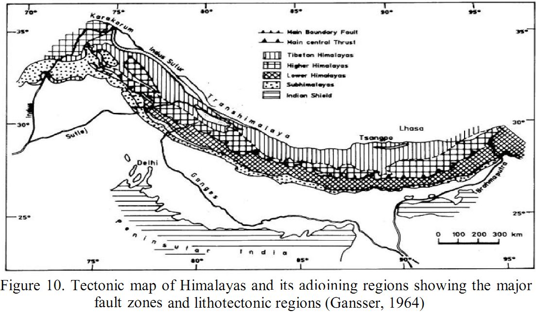
Figure 10. Tectonic map of Himalayas and its adjoining regions showing the major fault zones and lithotectonic regions (Gansser, 1964)
Source: http://www.scielo.org.mx/img/revistas/geoint/v46n1/a4f1.jpg
The termination of granitic magmatism in the Ladakh batholith is at the same time with the closing of Neo-Tethys along the ISZ and the change from marine to continental sedimentation. Clasts of granites, andesites and rhyolites are particularly widespread in the conglomerates of the Chogdo, Nurla and Hemis Formations of the Indus Group molasse, which unconformably, overlies the batholith. Volcanic rocks overlying the Ladakh batholith include andesites and rhyolites (Srimal et al., 1987). Late-stage garnet-muscovite leucogranitic dykes intrude the granite and may reflect a final phase of intracrustal melting after the 50 Ma collision along the ISZ. Granitoids of the Ladakh batholith intrude the Dras island arc volcanics and rocks of the suture zone around Kargil. This provides strong evidence that the Dras island arc was accreted to the Karakoram-Lhasa Blocks by the mid-Cretaceous and that the Shyok (Northern) Suture between the Ladakh and Karakoram terranes closed in the mid-Cretaceous (Coward et al., 1986; Pudsey, 1986; Searle et al., 1988) and not in the late Tertiary (Thakur, 1981, 1987). The Ladakh batholith has undergone an unknown amount of post-collision shortening evidenced by thrusting within the granitoids. Near Kargil, a number of late stage shear zones with mylonitized amphibolites and greenschists cut intrusive rocks of the batholith are found.
Indus Suture Zone (ISZ): The Indus Suture Zone (ISZ) defines the zone of the collision between the Indian Plate and the Karakoram-Lhasa Block to the north (Gansser, 1964, 1977; Allegre et al., 1984; Searle et al. 1987) and can be traced for over 2000 km from Kohistan and Ladakh in the east right across southern Tibet to the NE Frontier region of India-Burma. In Tibet it is commonly referred to as the Yarlung-Tsangpo Suture; in the western Himalaya it is the Indus Suture Zone. To the west of Ladakh, the ISZ is folded around the giant Nanga Parbat fold, a 35 km wavelength, upright anticlinorium that exposes Indian Plate gneisses equivalent to the Central Crystalline Complex in its core (figure 11). The ISZ has been offset by the late Tertiary culmination of Nanga Parbat and downfaulted west of Nanga Parbat along the Rakhiot Fault zone. It continues westwards as the Main Mantle Thrust (MMT) across southern Kohistan (Tahirkheli & Jan, 1979). In Ladakh, the Indus Suture is bounded to the south by the backthrust shelf sediments of the Zanskar Supergroup and the Tso Morari crystalline complex, and to the north by the Ladakh batholith. The geology of the ISZ has been described by Gupta & Kumar (1975), Shah et al. (1976), Andrieux et al. (1981), Fuchs (1977, 1979), Bassoullet et al. (1978, 1981), Frank et al. (1977), Baud et al. (1982), Brookfield & Andrews-Speed (1984a, b), Thakur (1981, 1987) and Searle (1983, 1986). The Indus Suture Zone in Ladakh consists essentially of three major linear thrust belts, the Lamayuru complex, the Nindam-Dras Volcanic Group and the Indus Group molasse. They are separated by major fault zones or ophiolitic melange belts (figure 7 a, plate 1). Figure 4 is a palaeogeographic reconstruction of the Neo-Tethyan basin showing the pre-Eocene stratigraphy of the rocks now preserved in the ISZ in Ladakh.
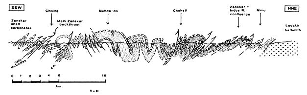
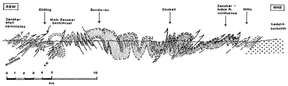
Figure 11: Structural section along the Zanskar River between Chilling and Nimu about 40 km west of Leh.
Indus Group molasses: The term “molasses” refers to the sandstones, shales and conglomerates formed as terrestrial or shallow marine deposits in front of rising mountain chains. A continental clastic sequence approximately 2000 m in thickness, comprising alluvial fan, braided stream and fluvio-lacustrine sediments, constitutes the Indus Group (Brookfield & Andrews-Speed, 1984 a,b; Van Haver, 1984). Clasts in the conglomerates were derived mainly from the uplifted and eroded Ladakh batholith to the north, but also from the suture zone itself (cherts, limestones, serpentinised peridotites) and from the Zanskar shelf carbonates to the south. Palaeo-currents show dominantly east to west basin axis-parallel sediment transport paths (Pickering et al., I987). Near Kargil the Indus molasse unconformably rests on the Ladakh granitoids along the northern margin of the ISZ. The collision of India with the Karakoram and Lhasa Blocks and the closing of Tethys at 50 Ma mark the initiation of Indus Group molasse sedimentation (Searle et al., 1987). The Chogdo Formation at the base of the molasse rests stratigraphically above late Palaeo.
Tectonic Origin of the Himalayas: The magnificent heights to which the Himalayas have been uplifted is as a result of several orogenic movements. The tectonic history of the Himalayas is a much debated subject. Some workers have recognized five phases of deformation on the basis of small scale shortening structures. Others have deciphered four major tectonic movements, the earliest dating back to the Precambrian or Lower Paleozoic, while the other three postdating the Permian. A few workers however, recognise only three episodes of orogenic activity, post-dating the Cretaceous.
The first phase of Himalayan orogeny-the Daling event (Precambrian or Lower Paleozoic) is marked by medium grade metamorphism but intense deformation accompanied by both acid and basic igneous intrusives. The second phase of orogeny known as the Ladakh phase involved the beginning of earth movements which were responsible for the major uplift of the Himalayas. It is during this phase that the Indian plate is believed to have collided with the Asian plate. This caused a shallowing of seas, emplacement of ophiolites along the Indus Suture zone, granitic intrusions, palingenesis, and granitization. Patches of Eocene rocks over the Tal (Jurassic), Krols (Permo-Trias), Simla Slates (Paleozoic), and Deoban rocks (Paleozoic) indicate folding and erosion of these sedimentary basins before transgression of the sea in Eocene period, and subsequent deposition of Eocene sediments. This phase of the Himalayan orogeny was active from Late Cretaceous to early Eocene times.
The third and most vigorous of all orogenic movements is termed the Dharamsala phase which culminated in the Middle Miocene. The consequent compression due to under-thrusting of the Indian plate beneath the Tibetan (=Asian) plate caused large scale isoclinal and recumbent folding of the Precambrian crystalline rocks. This resulted in the thrusting of huge blocks of these rocks that moved southwards, and came to rest upon the younger sedimentaries. Most of the thrust sheets of the Lesser Himalayas and widespread regional metamorphism and acid igneous activity are associated with this phase. Due to the great uplifting, a foredeep was created in front of the rising Himalayas into which the Siwalik molasse sediments were deposited.
The fourth phase of Himalayasn orogeny is the Siwalik phase. This phase was very active from the Late Pliocene to Middle Pliestocene period. Most of the present structures of the Himalayas developed during this phase. The Siwalik sediments were also uplifted. Tectonic creep along some of the thrust faults of the Himalayas, translation of upper Siwalik rocks over the subrecent gravel beds, and seismicity in the region strongly suggest that this phase has not yet ceased.
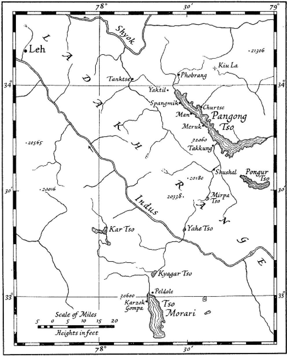
Increase in the level of Indo-Tibetian Highland lakes assosciated with Climatic changes: The earlier visits to Tibetan high altitude lakes (Figure 12) by Godwin Austen in 1866 recorded and evidenced the Ice Age, which out shed the attention of the important processes like erosive and bathymetric evidences of recent climatic oscillatory changes. In 1905 Huntington E observed Pangong Tso showing a set of benches and beach lines which lie lower than any of the older terraces surrounding the lake. During summer 1932 Terra and Hutchinson visited several lakes like Pangong, Pongur, Mirpa, Morari and Kar in eastern ladakh along Kashmir-Tibetian Boundary. The investigations have provided new informations regarding changes of depth, of shore features, and related phenomena attributed to regional climatic oscillations. The reasons for the recent changes of the high altitude lake-levels were attributed to topographic, physiographic and hydrographic alterations.
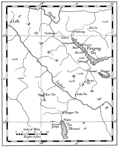
Figure 12: The topto map showing the Pangong Tso lake and other high altitude Indo-Tibetian lakes
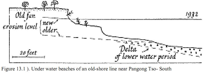
The Pangong Tso, being the largest mountain lake north of the Himalaya (13, 915 feet above sea-level), gave the first evidence of recent topographic changes. Terra and Hutchinson (1932) noticed the base of the cliffs near northern shore between Churtse and Lukung were flooded and observed the earlier path for traveling could be seen to lead into the lake, where the path continued 5 feet below the water and around the cliff. Two drowned beaches at 3 and 5 feet which may also be recognized on Figure 13.1).
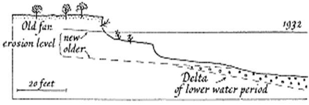
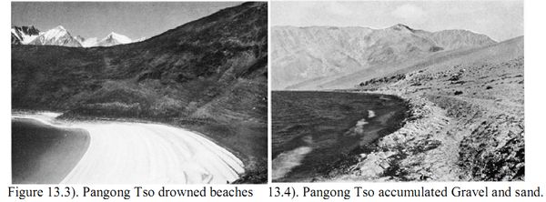
Figure 13.1 ). Under water beaches of an old-shore line near Pangong Tso- South
According to Hutchinson the landmark a rocky islet (1/4 th of a mile from the shore at Yaktil) had been marked as lying 5 feet above the lake-level on the old survey sheet does not exist during the visit. As the shallowest water was 13.1 feet at the spot where the islets had been in 1861. Thus the lake had risen since then at-least 18 feet.
Along the Southern part of Pangong Lake from Lukung to Man and Takkung further strengthened the rising levels of the lake by strong physiographic evidences. The fan formation making the lake front is seen to be superimposed on the pleistocene deposits and is therefore of post-glacial origin. At the slope of a cliff between Yaktil and Spangmik two distinct beach lines were recorded at 3 and 5 feet above the water, and a third could be seen in the clear water 2 to 3 feet below the level of the lake. Shortly before reaching this spot the path makes a detour around the advancing water of a shallow bay. In some of the shallower flood channels a more recent heavy accumulation of gravel had taken place.
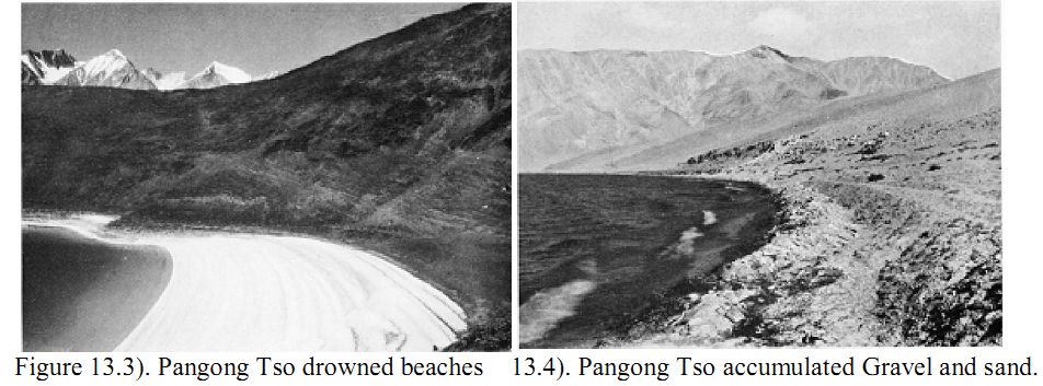
Twelve miles south-east of Takkung the underwater beaches were seen to follow the contours of an old shore-line (Fig. 13.3). A small delta had here been built into the lake, and as the underwater beaches broke abruptly off along the drowned shallow flood-channel of the rivulet it is evident that the beach preceded the delta. Larger bushes could still be seen clinging to the upper beaches while others had already become uprooted and were tossed about by the waves. The rising lake water had then flooded these shore features until the lake is now cutting into the front of the older fan.
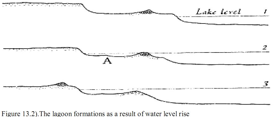
Another interesting and important physiographic change connected with the rise of the Pangong is the formation of small lagoons. They appear in parallel rows along the shore and in one place two could be seen at distances of 3 and 10 feet from the shore. Fig. 13.2) illustrates how their peculiar arrangement can be explained by a progressive rise of the lake-level. Their formation is greatly assisted by preceding shore-ice action. The accumulation of gravel and sand in the form of ridges is a common feature along Tibetan lakes (Figure 13.4.). Owing to the severity of the frost, which keeps the lakes solidly icebound during four or five months of the year, shore-ice is a much greater factor of accumulation than around lowland lakes in middle latitudes. Most lagoons on Pangong can be traced back to the same process; particularly where low terraced fans have become inundated, this indicates a recent rise of the lake-level.
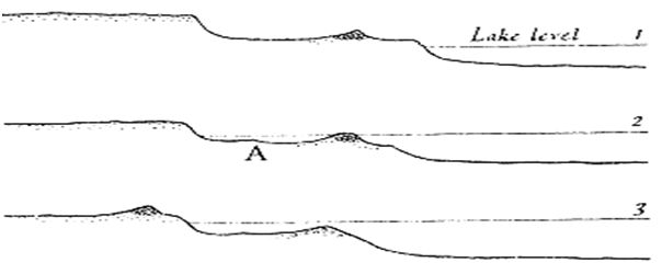
Figure 13.2). The lagoon formations as a result of water level rise
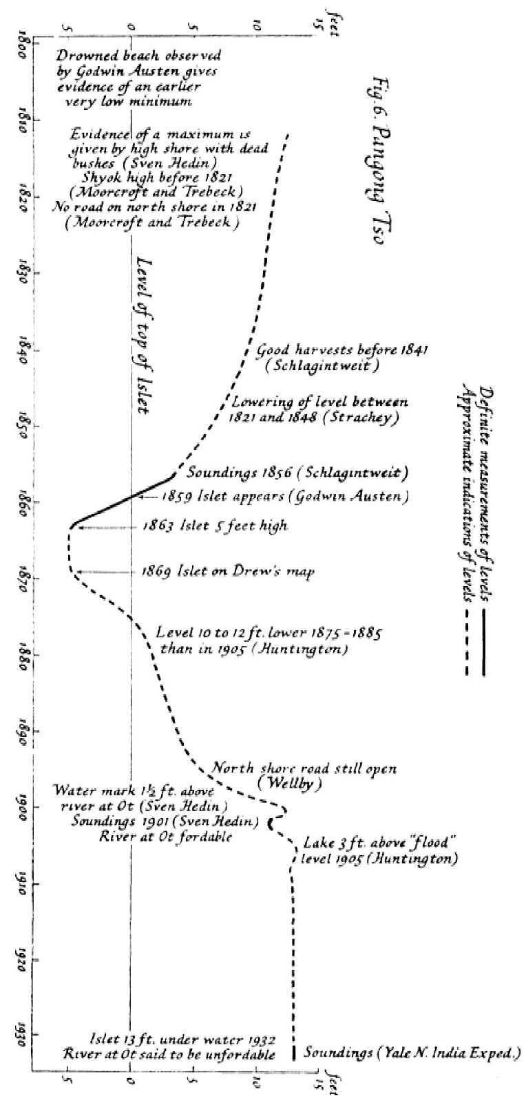
Historic records indicative of the sequence in changes of Pangong lake water level:
Figure 13.5 documents the changes in water level in Pangong lake.
- W. Moorcroft and G. Trebeck in 1831 gave the first account of Pangong Tso and mention the lack of a road along the northern shore in 1821.
- H. Strachey who visited the lake in 1848, remarks on the outflow of the eastern Pangong at Ot. They said that the lake had perceptibly receded in the last twenty-seven years.
- H. von Schlagintweit relates native information according to which higher lake-levels in connection with good harvests were frequent before 1841. In 1856 soundings were made but no rock islet is mentioned.
- H. H. Godwin Austen surveyed the rock islet in 1863 which appeared in 1859 above the lake-level. Shore roads were passable. He observed five to six beach-lines, 1 foot distant from each other, and also a submerged lake terrace, 10 feet below the 1863 level. From these phenomena they inferred climatic oscillations.
- In 1869 F. Drew observed pictures of the islet and mentions a total seasonal rise and fall of the lake by 3 feet.
- M. S. Wellby in 1898, had the choice to use either the shore route or the longer but safer one across the Poranda La.
- Sven Hedin gives soundings of 1900 and comments on the condition of the northern shore route which was inundated, but the river at Ot was fordable. The existence of an older road, 10 m.above the path which he followed, makes him believe that his road of 1900 was once flooded.
- E. Huntington observed in 1905 three to four small drowned beaches 10 to 12 feet below the level, and gives native information according to which the lake was 10 to 12 feet lower during I875-85. Although he recognized that oscillations were recent he attempted to couple them with the formation of clay and gravel deposits near Man which Godwin Austen in 1866 had rightly interpreted to be of glacial and interglacial origin.
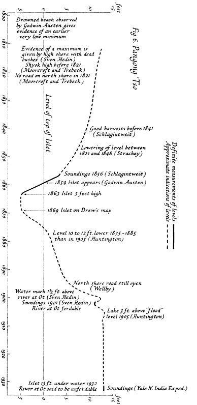
Figure 13.5). History of rising levels of Pangong Tso lake
Ladakh Region: Ladakh is situated between 30° to 36° E latitude and 76° to 79° N longitude. It is part of the state of Jammu and Kashmir, has an area of 96,701 sq. km and comprising a population of 200,000 habitants. Ladakh is bounded on the north by the eastern range of the Karakoram Mountains and the Tibetan Plateau. Across the Kashmir Valley and over the famous Zoji La pass (Zozi La pass) lies Ladakh – “the Land of High Passes”. It is a magical land, so completely different from the green landscape of some other parts of the Himalayas. It is nature at its extreme. A land of freezing winds and burning hot sunlight, Ladakh is a cold desert lying in the rain shadow of the Great Himalayas and other smaller ranges. Little rain and snow reaches this dry area, where the natural forces have created a fantastic landscape. Parts of Ladakh are under the illegal occupation of Pakistan and China, respectively. The border of Ladakh touches those of Afghanistan, Pakistan, China, the Kashmir Valley (India) and Himachal Pradesh (India).
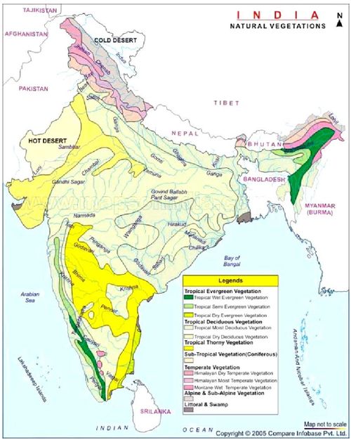
Figure 14: Indian vegetation with biogeographic regions
Sources: http://www.mapsofindia.com/maps/india/natural-vegetation-india.jpg
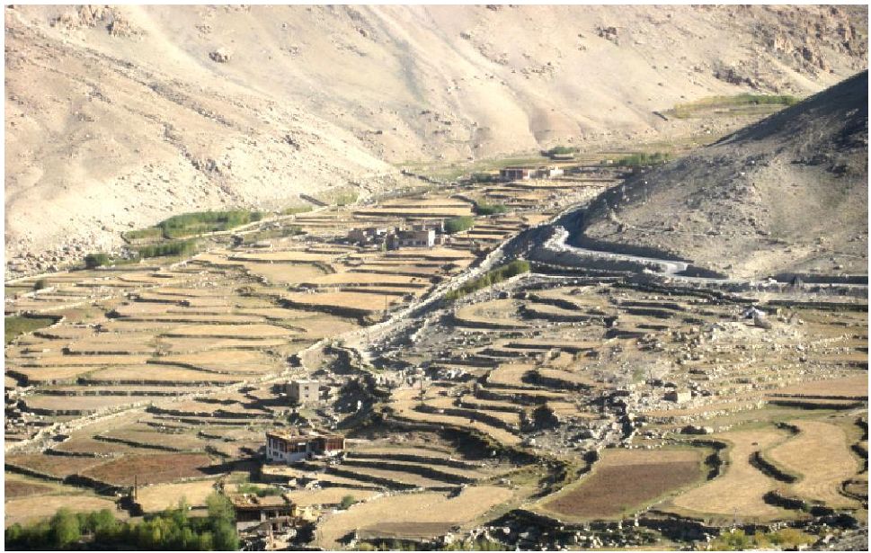
Ladakh has an average elevation of 2,700 m to 4,200 m. The aridity of this region is due to its location in the rain shadow area of the Great Himalayas, elevation and radiation of heat from the bare soil. The great Himalaya mountain, lying to the south, forms a barrier to monsoon in this area. The most striking physical feature of Ladakh, however, is the parallelism of its mountain ranges. The region is extremely dry, with rainfall as low as 10 cm each year. . It has many lakes and springs, the famous springs are the sulphar springs of Panamic (Nobra), Chumathang and Puga of Changthang, which are famous for early curing of joints/ rheumatic diseases. Many mineral springs are also found in some remote parts of Ladakh. People of region use the spring water as medicine to prevent and cure themselves from many diseases. In Ladakh, large rivers and their tributaries have carved deep gorges far below their steep banks. However, their water is not of much use as the terraced fields (Figure 15.1) lie high above the gorges.
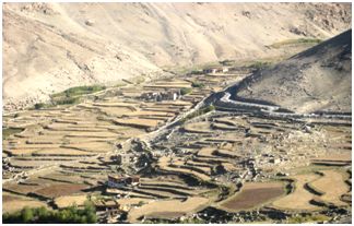
Figure 15.1. The terrace type of cultivation in the cold arid deserts of Leh, Ladakh.
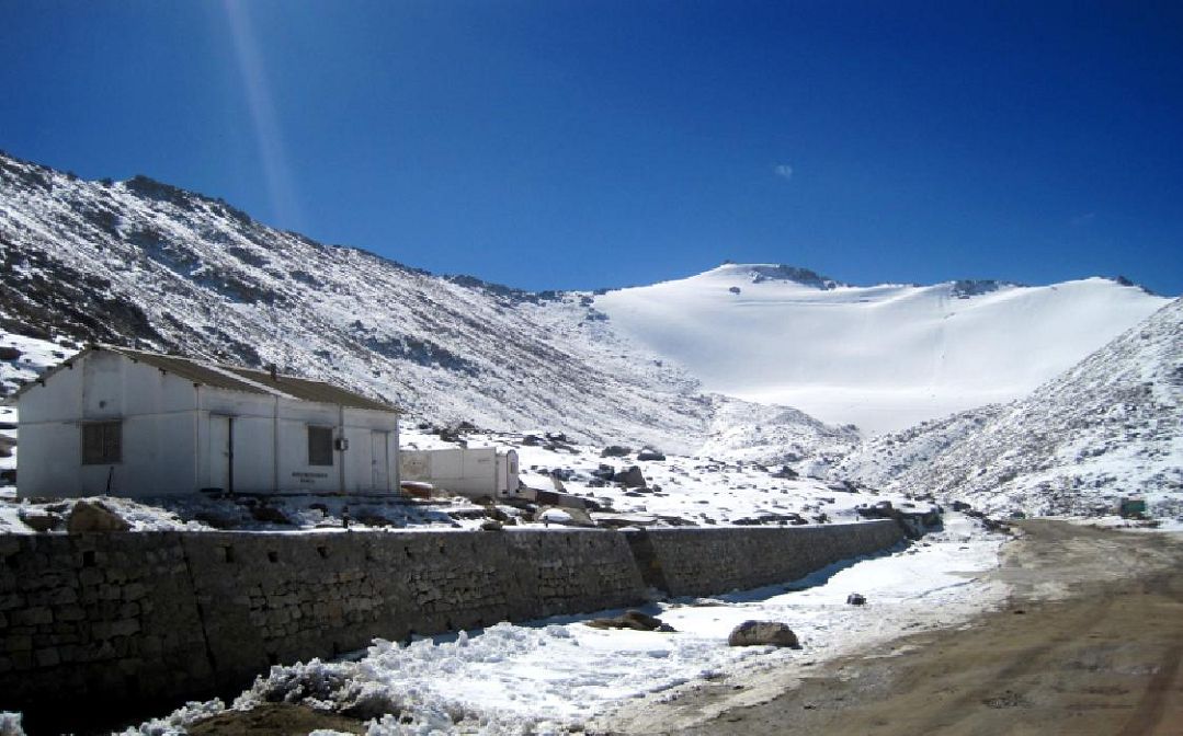
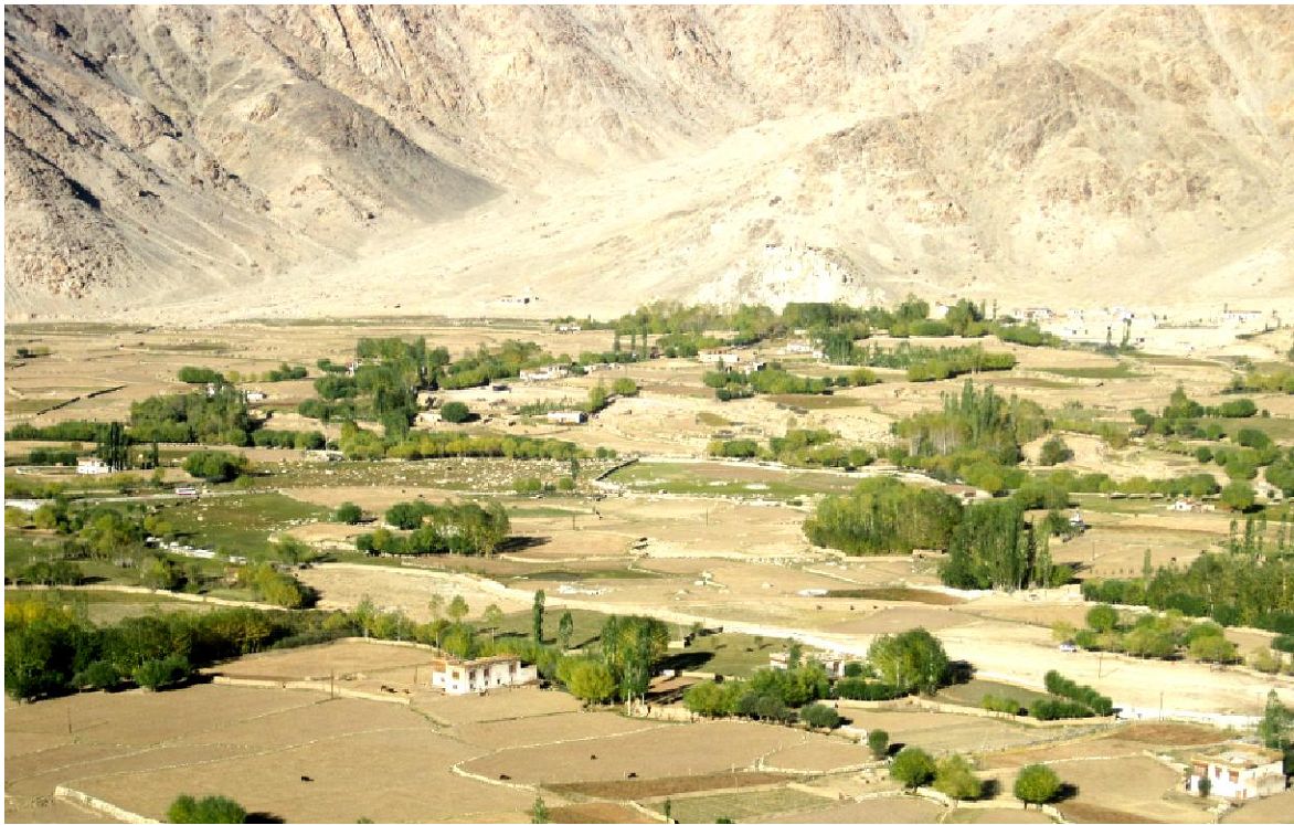
Earlier Ladakh could only be reached over high passes (Figure 15.2). The Zoji La pass connecting Ladakh to Kashmir is at 14,000 ft and is the lowest approach from the west. The south east approach has to cross the 18,200 ft high Tanglang La. And to the north lie the Saser La and Karakoram passes, gateways to Central Asia from where trading caravans used to come for many centuries. The altitude ranges from 3000 m (lower Indus and Nubra valleys) to 7600 m (Zanskar and Karakoram ranges) (Gujja et al., 2003). The region of Ladakh normally remains land locked between November to June every year as Srinagar-Ladakh and Ladakh - Manali highways, which connect Ladakh with the other parts of the country, remain closed during this period because of snow and rigorous winter. Due to this region Ladakh is an isolated cold desert region. Figure 15.3 gives the glimpse the dry vegetation mostly Poplar and Willow at Leh, Ladakh.
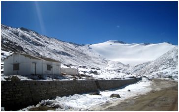
Figure 15.2. The Changla pass on the way to Pangong Tso.
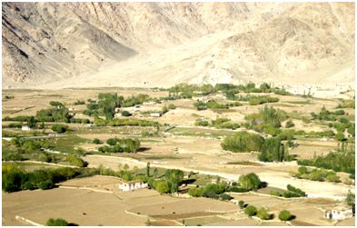
Figure 15.3: The dry vegetation mostly Poplar and Willow at Leh, Ladakh.
There are two districts in the Ladakh region, Leh and Kargil, with Leh as the administrative capital. The 21,000 sq.km Changthang sub-division is part of Leh district, with high mountains, wide-open valleys, natural grasslands, and snow-fed streams (jammukashmir.nic.in).
The State Government intends to declare an area of 4000 sq.km in eastern Ladakh at Changthang as a sanctuary (Fig. 16). This area is a barren cold desert sparsely wooded and experiences the severe cold in the region. Thus named as High altitude cold desert Changthang Wildlife Sanctuary. It is located in the North-east of Leh and constitutes the eastern parts of the Ladakh region, at a distance of about 130 km from Leh. The area falls at 34 – 79 degree north longitude and 33 – 79 degree east latitude. This sanctuary includes the water catchment of the Indus River, Hanlay, and Pangong Tso enrooting south-eastern catchment up to China border.The boundaries of Changthang Wildlife Sanctuary are as follows: (i) North – Chilam and Lukoong (ii) South – Kaigar – Tso and Hanlay (iii) East – International boundary of China. And (iv) West – Spanger – Tso and Spangong – Tso.
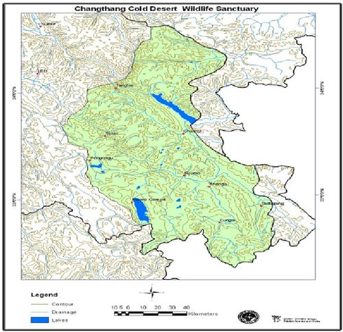
Figure 16:. Changthang Wildlife Sanctuary.
Study Area: Pangong tso
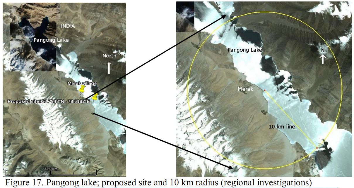
Pangong Tso is a part of the protected area (Figure 17). It has been proposed for Ramsar site due to its biological cultural and geological values (Chatterjee et al., 2002). The Ministry of Environment and Forest, Government of India has identified Pangong Tso under the Wetland conservation Programme (Islam & Rahmani, 2008). The Salim Ali Centre for Ornithology and Natural History, Coimbatore has recommended it to be declared as a Ramsar Site (Prasad et al., 2004).
Pangong Tso represents unique brackish ecosystem example of the highest (4300 m) and largest (50 x 6 km) in India side and remain 75 x 6 km in Tibetan (Chinese) side wetland of the Trans-Himalayan biogeographic Zone of the Indian sub-continent. The adjoining areas of the wet-side abodes high diversity of endemic, rare, and vulnerable species. Pangong Tso is an important breeding area for Ruddy Shelduck and Bar-headed Goose. This lake acts as a stagging and foraging ground for birds, especially on the marshes on the fringe of this Lake (Pfister, 2005; Chandan et al., 2005). Local people graze their livestock in the marshes and meadows, and harvest the grasses for fodder very close to the nesting birds is a conservation issues (Islam & Rahmani, 2008).
The tourists have been seen in Pangong Tso during summer months, from the year 1993, with the opening of the Changthang Wilderness area to the outsiders. The adjacent areas of the Pangong Tso- Wetland having steppe cold desert ecosystem is bestowed with many types of floral species. These provide ample grounds to the “Changpa” pastoral-nomads who take advantage of these grounds on seasonal basis. Since, all the adjacent village-folk are dependent on the raring of the “Pashmina goat”. The wetland invariably helping the economy of the local people.
Pangong Tso- is one of the Wet-site of Changthang Cold desert Wild life sanctuary. The area remained notified as Wildlife Protected area under SRO no. 155 dt. 19-03-1987 issued under the purview- of the J&K Wildlife protection Act (1978) section 17. The ownership of the wet-site remains with the Department of Wildlife Protection J&K State Leh Division” However, some of the surrounding areas of Spangmik, Man, Merak, Chushul are belonging of the local Pangong Tso, at Man-Merak is owned by Indian Astronomical Observation to understand the fundamental processes taking place on the Sun. The current proposal is to construct a 2 m state-of-the-art telescope class telescope (National Large Solar Telescope (NLST)) at this site (Fig. 17 and 18). The proposed site is very close to the Pangong Tso Lake and inside the Changthang Wildlife Sanctuary, which has endemic, endangered species.
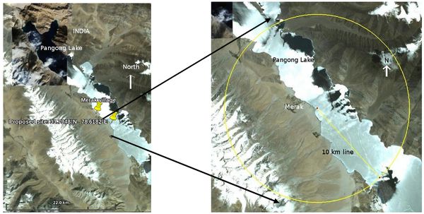
Figure 17. Pangong lake; proposed site and 10 km radius (regional investigations)
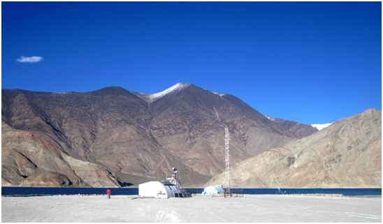
Figure 18. Merak Observatory
The area is of adequate ecological, faunal, floral, geomorphological or natural significance, for the purpose of protecting, propagating or developing wildlife or its environment, including areas adjacent to national parks and those which link one protected area with another. One of the most spectacular lakes in Ladakh is the Pangong Tso, which lies across the Changla Pass from Leh. At an altitude of almost 4,500 metres, the Pangong Tso is only 8 km wide at its broadest point, but is an amazing 134km long. The Pangong is considered to be the longest lake in Ladakh. It is a saltwater lake formed in much the same way as the Tso Morari lake during the Ice Age.
It is a lake situated far away in barren land in Ladakh. This lake is known for its calm, clear and unending expanse. It is the one of biggest lake in Asia. Its area falls under both India and China. One third of it is in India and remaining in China. It is 130 km long and 7 km wide. It is located on the Changtang plateau in eastern Ladakh, around 140 km South-east of Leh, at an altitude of over 14000 feet. Pangong Tso is also known as hollow lake. It is clear symbol of natures craftsmanship. Its brackish water plays with sun light to produce different colour effect. This area falls under army control and requires pass from deputy commissioner of Leh. To reach this lake one has to travel 30 km down the Manali-leh highway to reach karu. From where the road splits, one goes to Manali and one 113 km long to Pangong tso. After the verification of paper at karu, one moves ahead through a green lush valley. This is very uncommon to see a green valley at this height. There are total five army check posts are on the road to Pangong Tso. The second check post is at Zingral (15,500 ft). Here army keeps a copy of the permit. This is rocky area and porn for land slide.
This rocky terrain leads to Chang La (at 17,350 ft), the third-highest motor able pass in the world. Traces of snow along the road welcome us. One crosses the valley on the sinking road. The mountains appeared to be painted in hue of green, violet and brown. A school of mountaineering is situated here, which imparts training in various degree of rock climbing Soon we found our self in pasture which is filled with yaks, mountain cows. The rocky mountain changes into sandy area. The road is full of causeway due water on the road.
Pangong appears suddenly while passing through this area. Just two km short of lake one passes through the gravelly terrain, which is open on the left side. After crossing Lukung, the lake emerges out of its veil in right. This land lock lake stretches through the whole length of Ruthog region towards neighboring Chushul. Stretched towards indo-china border, it enters into china. Most of the fresh water inlets that feed the lake are in Tibet. It is 100 metres deep at certain places.
The sun plays a unique role in displaying the different colours in lake. Its crystal clear water plays with sun light to display the bands of blue, green, purple, violet, orange and red on the surface, like a rainbow. This presents a very beautiful seeing. The lake looks like canvas painted in the different colours of nature. With no outlet, Lake Basin has deposited wealth of mineral, by the melting of snow. The lake is home to a wide range of fauna ranging from migratory birds to mammals of various species. The black-necked Siberian crane, bar-headed geese and waterfowl can be spotted at the lake.
Pangong Tso Wetland Reserve: Pangong Tso – Tsogul Tso wetland situated on the “North East” of Leh city, is 150 kms away from it. The Leh district administrative district. The population of the Leh town as per 1991 census was 11000. The Tangtse town falling on the North – west of the wet-site is 110 kms from it and the nearest Centre/ village of the wetland is Spangmik on its Southern side just near the shore of lake. The jurisdiction of the wetland rests with the Govt of Jammu and Kashmir State (India) and the functional Jurisdiction of the wetland lies with the Deptt . Of Wildlife Protection, J&K State and its Divisional Wing, Wildlife Division, Leh Ladakh.
The population of the Centre/ village Spangmik, Man, Merak and Chushul with its cattle-head 1993-1994 was: 111 families and 219 persons. Livestock details are given in Table 2.
Table 2: Livestock
| Cow |
Sheep |
Goat |
Horse |
Yalk/Demo |
Donkey |
Dzo/zomo |
Total |
| 290 |
3396 |
9126 |
337 |
816 |
15 |
7 |
13987 |
Hydrologicl values: Due to high velocity and frost actions around the wet-site on regular basis, plays a major role in rock denudation and its transportation. Huge quantities of sand segments are deposited in the Wetland.
Ecological features: The lake shows monomictic and oligotrophic to ultra -oligiotrophic status. The deeper parts of the lake are devoid off of any vegetation. However, the vegetation appear near the margins of the wetland, on the steppe mounts, wet meadows and the bogs have abundant plant life. The steppe vegetation includes, Herbs/Legumes, like,
- Pedicularis longifolia.
- Polygonium spp.
- Parmassia cabuilica.
- Gentiana leucomeleana.
- Oxytropis microphylla.
- Potentila aniserina.
- Leontopodium spp.
- Astragalus confertus.
- Juncus spp.
Towards the northern and eastern side of the wetland, some sedge and grass species dominate the area. They are:
- Carex steaophylla.
- Heontopodium spp. Or Trigolochin pulustoel.
- Caragana brivifolia.
- Dracocepholium spp.
Besides, this Caragana spp. dominate the northern end had played major role in sand trapping. Among macrophytes, Potamageton pectinatius is the dominating species, whereas zooplanktons are more varied than the Phytoplanktons, they are:
- Keratella spp.
- Alona spp.
- Daphnia spp.
- Gammarus spp.
- Cyclops spp.
Besides this algal species oocystis species can be seen in this area. The people of the Spangmech, Man, Merak developed some crops vegetation of Barley (Hordeum spp.); Goosbery (Ribes); towards southern area of the wetland.
Noteworthy flora: The flora including sonme wild legumes, macrophytes, grasses, sedges and some other above mentioned plants are all representatives of the steppe vegetation of the Trans-Himalayas ecosystem and thus all play their vital role in the system.
Social and cultural values: With the opening of the Changthang Wilderness area to the outsiders from the year 1993 tremendous influx of the tourist have been seen in Pangong Tso. Tourist approach the area in thousands during summer months. The nmber is mainly of foreigners who approach the area from Leh. All the tourists are being accompanied by the local tour operator and travel agents leading in-direct ecological benefits to the Spangmik, Mulbek villages.
The adjacent areas of the Pangong Tso Wetland having steppe cold desert ecosystem bestowed with many types of floral species. These provide ample grounds to the “Changpa” pastoral-nomads who take advantage of these grounds on seasonal basis. Since, all the adjacent village-folk are dependent on the raring of the Pashmina goat. The wetland invariably helps the economy of the local people.
Cultural land use: The human activities inside the proposed Ramsar site ie. Pangong Tso wetlands are nil. However the adjacent areas of the wetland are mainly used by the local people. All the village-folk around or outside the wet-site area are dependent on the rearing of the Pashmina Goat and are mostly living Pastoral-nomadic life. They are solely dependent upon the availability of the floral species existing around the steppe-mounts of the wetland. Since 1994. Tourism trade helped a little to the people of the village falling around wetland Agricultural practices are being exercised by the local people of Spangmik, Man, Merak on the southern steppe side of the lake. They grow Millets, Barley and local pea species.
Factors past present or potential adversely affecting the sites ecological character including changes in land use and development projects: The regular speedy winds transport large amount of sand into the wetland. Besides it huge soil erosion took place during summer. Months due to glaciations from the surrounding mounts. The ice melting water straight way merge into the wetland through five perennial and three small streams. All these natural calamities bring large amount of sand and soil reducing the wetland size helping in its shrinkage.
Overgrazing of the area by the Live-Stock Changpa Pastrol and nomads who are dependent on rearing of "Pashmina" goats have posed adverse impact on the biodiversity on the wetland. As overgrazing results in pasture degradation increased soil erosion it also leads to the less availability of grasses for wild herbivore and indirectly the Carnivores are invading the Cattle-pens rendering heavy loss to the nomads.
The area of Pangong Tso Wetland is one of the Wet-site of the Changthang Wildlife Sanctuary. The area of 4000 Sq.Kms stands notified as Wildlife Sanetnary since 19-03-1987. The same wet-site is protected under the overview of J&K Wildlife Protection Act 1978. Since the people living around Pangollg Tso are fond of Wildlife, cases of hunting/poaching are almost zero. Any kind of developmental activities would not be carried out without the cognizance of the Wildlife Protection Department, as all the powers about the wetland vests with the Department. With the opening of the Pangong Tso Wetland to tourist in 1994 the influx of the tourist especially from Western Countries like France, Belgium, Sweden, Germany, and asian country like Israel, has increased exponentially. The tourist who made their way through Leh (J&K) and Delhi are being attracted by the wetlands remoteness it is variegated and unique flora fauna pristine high desert landscapes, culture tradition of Buddhist and age old Monastery of "Tangtse". These tourists are being allowed to enter in the wetland only after obtaining a “Inner Line Permission" from the Deputy Commissioner Leh.