 |
WEB BASED SPATIAL DECISION SUPPORT SYSTEM FOR SUSTENANCE OF WESTERN GHATS BIODIVERSITY, ECOLOGY AND HYDROLOGY |
 |
aEnergy & Wetlands Research Group, Center for Ecological Sciences [CES],
bCentre for Sustainable Technologies (astra),
c Centre for infrastructure, Sustainable Transportation and Urban Planning [CiSTUP]
Indian Institute of Science, Bangalore, Karnataka, 560 012, India
dLab of Spatial Informatics, IIIT-H, Hyderabad, India.
http://ces.iisc.ac.in/energy; http://ces.iisc.ac.in/biodiversity
E Mail: cestvr@ces.iisc.ac.in; tara@ces.iisc.ac.in; settur@ces.iisc.ac.in
E Mail:cestvr@ces.iisc.ac.in; tara@ces.iisc.ac.in; settur@ces.iisc.ac.in
|
RESULTS
The WSDSS provides and integrate framework for easy access of information and evaluation with a unified user interface, comprising fully menu-driven graphical user interface, with a built in context sensitive help features, designed by incorporating web technologies and open source tools special feature of the database is its handling, display and analysis of observation time series data, with a linkage to real time data and monitoring with comparative analyses of various scenarios and effective graphical outcomes. The user interface is as outlined in Fig. 3. Multiple options are visualized (state/district wise) with the Western Ghats as backdrop (OpenStreetMap or Bhuvan) is shown in Fig. 4. The selected district is highlighted with various variables information (Fig. 5-8). The Uttara Kannada region is considered for visualization and WSDSS evaluation. The user has option to select and query variables under each theme to evaluate (Fig. 9). The querying is allowed to generate user defined maps, for example population density map generated based on the query. The aggregated rank corresponding to biological, ecological, geo-climatic, renewable energy and social variables is analyzed to prioritize ecologically sensitive regions (ESR) and graded as ESR 1, ESR 2, ESR 3 and ESR 4 respectively (Fig. 10). Uttara Kannada district has 209 panchayats and among these, 102 panchayats are in ESR 1, 37 panchayats in ESR 2, 33 panchayats in ESR 3 and 37 in ESR 4. Sahyadri and eastern part of coastal regions represents highest ecological sensitivity.
The ESR 1 represents ecologically highly sensitive requiring strict conservation measures with sustainable management involving VFCs (Village forest committees). ESR 2 is as good as ESR 1, except degradation of forest patches in some localities. ESR 3 represents moderate conservation region and only regulated development is allowed in these areas. ESR 4 represents less ecological sensitiveness. The non-spatial data also been provided for the better understanding of region’s status in terms of reports. The regulated and restricted activities in ESR also provided as a report form to further aid in decision making. The sustainable developmental framework has provided for the management of ESR with improvement of environment by public private partnership and distributed development. This also points out to establish a well ordered decision making process by regulatory authorities, which include stake holder’s involvement and their priorities for livelihood. Moreover, maps can be integrated with real-time analysis and visualization tools into collaborative environments to support group decision-making.
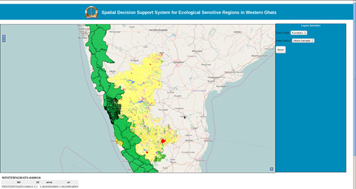 Fig. 3: Western Ghats WSDS. Fig. 3: Western Ghats WSDS.

Fig. 4: The Western Ghats as shown in OpenStreetMap backdrop (WMS).
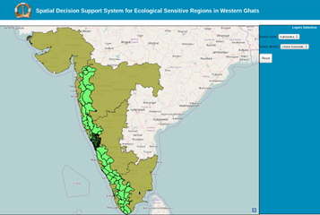
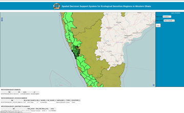

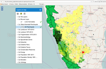
Fig. (5-8): The selection of region in Wester Ghats based on user input.
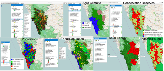
Fig. 9: The thematic maps of various variables considered and their information.
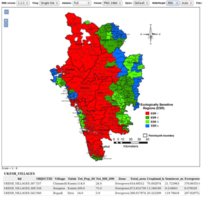
Fig. 10: Ecologically sensitive regions of Uttara Kannada based on MCDA.
|
|
Citation : T.V. Ramachandra, Tara N M , Bharath Setturu, (2017). Web Based Spatial Decision Support System for Sustenance of Western Ghats Biodiversity, Ecology and Hydrology. Creativity and Congition in Art and Design, Edited by Aneesha Sharma and Jamuna Rajeswaran, PP: 58–70.
|