¦ ¦ ¦ ¦ ¦
ENVIS Technical Report 91,   April 2015
ENVIRONMENTAL FLOW ASSESSMENT IN YETTINAHOLE:
WHERE IS 24 TMC TO DIVERT?
1Energy & Wetlands Research Group, Centre for Ecological Sciences, 2Centre for Sustainable Technologies (astra),
3Centre for infrastructure, Sustainable Transportation and Urban Planning [CiSTUP], Indian Institute of Science, Bangalore, Karnataka, 560 012, India.
E Mail: cestvr@ces.iisc.ernet.in; vinay@ces.iisc.ernet.in; bharath@ces.iisc.ernet.in, Tel: 91-080-22933099, 2293 3503 extn 101, 107, 113
Study Area

Yettinaholé catchment as a whole has a pristine ecosystem with rich biodiversity. The proposed dam/weir sites falls in Sakaleshpura taluk of Hassan district of Karnataka. In order to tap electricity from the stream water, multiple weirs area proposed across various catchments of the yettinaholé and immediate water sheds, the details of the same are as depicted in Figure 4 and table 1, the catchments extend from 12044’N to 12058’N Latitude and 75037’E to 75047’E longitude encompassing total area of 179.68 km2. The terrain (figure 5) is undulating with altitude varying from 666m above MSL to 1292m above MSL leading to higher density of stream network (figure 6). Geologically, rock types consists of Gneiss, the soils are loamy ranging from sandy loamy to clay loamy. Soils (figure 7) in the region are fertile and highly permeable, hence allowing the precipitated water to percolate easily into the subsurface recharging ground water and storing water in the sub surfaces and hence keeping the water source perennial to the catchment and the downstream users during and post monsoon.

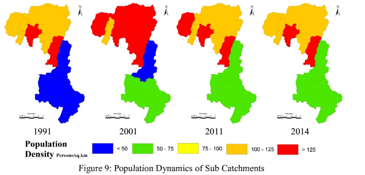
Decadal Population in Sakleshpura taluk of Hassan is as depicted in figure 8 and table 2 shows a declining trend post 2001, this could be attributed to the migrated population. Population dynamics of the catchments also follows the dynamics of Sakleshpura taluk. Total Population of all the catchments with respect to census data was estimated as 17005 in 2001, has declined to 16345 in 2011 at a decadal rate of 3.88%. Population for the year 2014 was calculated as 16156 based on the temporal data. Population density for each of the sub catchments are as depicted in figure 9 and table 3.

Table 1: Study Area

Sub basin id

Stream Name

Area (Ha)

1

Yettinaholé

4878.7

2

Yettinaholé T2

781.1

3

Yettinaholé T1

991.1

4

Kadumane holé 2

761.4

5

Kadumane holé 1

1362.4

6

Keri holé

5676.6

7

Hongada halla

2198.3

8

Yettinaholé lower reach

1319.1

Table 2: Population Growth of Sakleshpura Taluk

Census Year

1921

1931

1941

1951

1961

Population

44115

44300

43765

53398

77522

Census Year

1971

1981

1991

2001

2011

Population

91175

114008

124753

133657

128633

Source: Census India, http://www.hassan.nic.in/htmls/stat.htm

Figure 4: Study Area


Table 3: Population density (persons per sq.km)

Sub Basin Id

Sub basin

1991

2001

2011

2014

1

Yettina holé

117.86

126.92

122.00

120.59

2

Yettina holé T2

116.12

125.08

120.22

118.81

3

Yettina holé T1

126.52

136.31

130.96

129.45

4

Kadumane holé 2

108.36

116.76

112.17

110.98

5

Kadumane holé 1

121.33

130.65

125.58

124.12

6

Hongadahalla

47.26

50.89

48.92

48.36

7

Keri hole

32.71

35.25

33.89

33.48

8

Yettina holé lower reach

151.46

163.14

156.85

155.03

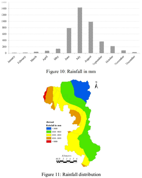
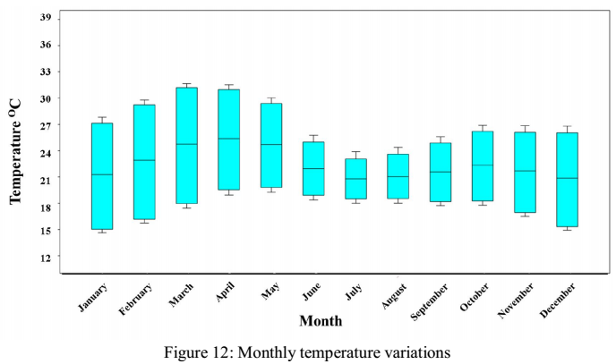
The region receives an annual rainfall of 3500 to 5000 mm across the catchment. Monthly variation of rainfall is as depicted in Figure 10 (Directorate of Economics and Statistics, Karnataka). Precipitation in the catchment during June to September is due to the southwest monsoons, with July having maximum rainfall over 1300 mm. Spatial variation of rainfall across the catchments was assessed based on 110 years data (1901 to 2010) from the rain gauge stations in and around the catchment (depicted in Figure 11). Monthly temperatures variations are as depicted in Figure 12 (http://worldclim.org), temperature in the catchment vary from as low as 14.7 °C in January to as high as 31.6 °C in March.

3.1 DATA: Data required for hydrological and spatial analyses were compiled from multiple agencies. Table 4 describes the various data used for assessment of the hydrological regime across the catchments. Data used include satellite remote sensing data acquired through Landsat 8 series of 2014. Rainfall data was acquired from Bureau of Economics and Statistics, Karnataka, Temperature data was sourced from worldclim of 1km resolution. Census data from government of India, state and district census departments. This data was supplemented with secondary data from various sources as tabulated in table 4. Data inventory was also done through field investigations and feedback from public


Table 4: Data used for land use and assessment of hydrologic regime

Data

Source

Description

Remote sensing data – spatial data

Landsat 8 Satellite, 2014 from USGS earth explorer (http://landsat.usgs.gov, http:// glcf.umd.edu/data/landsat/, http:// landsat.gsfc.nasa.gov/, http:// www.landsat.org/

Remote sensing data of 30m spatial resolution and 16 bit radiometric resolution were used to analyse the land use at catchment level

Rainfall

Rain gauge station wise – compiled from Directorate of Economics and Statistics – Karnataka (http://des.kar.nic.in/), India Meteorological Department (IMD), Pune (http://imdpune.gov.in).

Daily rainfall data for 110 year between 1901 and 2010. Used to assess the rainfall distribution over the basin

Crop Calendar

Agriculture Department of Karnataka, (http://raitamitra.kar.nic.in/), iKisan (http:// www.ikisan.com), National Food Security Mission (http://www.nfsm.gov.in/.

To understand when, where and which crops are grown which helps in understanding the crop water requirement based on the growth phases

Crop Coefficient

Food and Agriculture Organization- FAO (http://www.fao.org), Agriculture Department of Karnataka (http:// http://raitamitra.kar.nic.in/KAN/index.asp).

Each land use has its own evaporative coefficients, used to estimate the Actual Evapotranspiration.

Temperature (max, min, mean), Extraterrestrial solar radiation

Worldclim (http://www.worldclim.org/), FAO (http://www.fao.org), http://www.cru.uea.ac.uk, http:// climate.nasa.gov/, http:// data.giss.nasa.gov/gistemp/

Temperature data of 1km spatial resolution, available for each month. Extra-terrestrial solar radiation, every 10 North latitude available across different hemispheres for various months. Used to estimate the Potential Evapotranspiration

Population Census

Census India (http://censusindia. gov.in) 1991, 2001 and 2011

Data available at village level, used to estimate the population at sub basin level for the year 2014, and estimate the water requirement for domestic use at sub basin level

Livestock Census

Hassan District at a glance 2012-2013  (http://www.hassan.nic.in)

Taluk level data was used to estimate the livestock population and estimate water requirement at each of the river basins.

Digital Elevation data

Cartosat DEM from NRSC-Bhuvan (http://bhuvan.nrsc.gov.in)

Carto-DEM of 30m resolution. Used to derive the catchment boundaries, stream networks in association with Google earth and Toposheets

Secondary Data

Google Earth (http://earth. google.com), Bhuvan (http://bhuvan.nrsc.gov.in), French Institute Maps (http://www.ifpindia.org/.), Western Ghats biodiversity portal (http:// thewesternghats.indiabiodiversity.org/), the Survey of India topographic maps  (http://www.surveyofindia.gov.in/)

Supporting data in order to assist land use classification, delineation of streams/rivers/ Catchment, Geometric correction

Field data

GPS based field data,  data form public (stratified random sampling of households)

Geometric Corrections, Land use classification, Crop water requirement, livestock water requirement estimate

.       

E-mail     |     Sahyadri     |     ENVIS     |     GRASS     |     Energy     |     CES     |     CST     |     CiSTUP     |     IISc     |     E-mail