Silt Yield in Uttara Kannada District
6.1 Summary:
Soil erosion is the result of complex processes involving alteration of landscape structure due to denudation and transportation of surface soils, the process of frosting and thawing action of rocks, which is controlled by climatic, topographic, geologic, geomorphic, and land use characteristics. Anthropogenic activities leading to deforestation and agricultural intensification influence the rate of erosion and sedimentation. This section quantifies the silt yield based on land use of sub –basin and suggest measures to regulate unsustainable extraction of sand in this region.
Keywords: Silt yield, sedimentation
6.2 Introduction:
Soil erosion is a major environmental problem worldwide (Guobin et al 2006) where the sediment is detached from the soil surface both by raindrop impact and by the shearing force of flowing water (Manoj and Kothyari, 2001) and a major hazard threatening the productivity of agriculture (Julien and Simons 1985). Soil erosion is the result of complex processes of land denudation (CS/AR-22/1999-2000 NIH Roorkee; Bishop et al, 2002) involving the process of frosting and thawing action of rocks, denudation and transportation of surface soils, which is controlled by climatic, topographic, geologic, geomorphic, and land use characteristics (Chanarmohan et al 2002). Anthropogenic activities such as deforestation, urbanization and agricultural intensification influence the rate of erosion and sedimentation (Rabin and Dushmanta 2005). Climatic factors that affect the process of erosion include precipitation, temperature and wind (CS/AR-22/1999-2000 NIH Roorkee). Removal of vegetation cover and high intensity rainfall in Sharavathi river catchment has contributed to the transportation of silt corresponding to top layer of soil in the upstream (Ramachandra et al., 2007). Removal of top productive layer of soil has led to the reduction in soil productivity. This forced the farmers to switch over to inorganic fertilisers and pesticides. Consumption of fertilizer and pesticide is prevalent in the eastern part compared to other parts. This has contributed to pollution of water in the streams (Ramachandra et al., 2007). Based on the intensity of rainfall in the catchment associated with the land use and the soil characteristics, the exposed surface soil and weathered rock particles is carried along the water bodies and deposited along the stream/river beds, along the estuaries Varying temperatures causes the effect of expansion and shrinkage of rock surfaces, evaporation and transpiration, in the process the combined surface particles isolates. The soil particles that get transported through water get deposited in the bed and banks of dams, rivers, streams, canals, estuaries, and so on. Common types of water erosion are Ril and Interrill erosion (Fernandez et al 2003).Winds changes the velocity and angle of impact of raindrops, in the absence of rain, the winds carry the dust particles and displace to other locations.
The sediment deposition is a major problem that determines the reservoir life. It results in storage capacity losses, damage to valves and conduits and changes in water quality. The problem of sedimentation is taken care by providing sufficient dead storage. The rate of sedimentation is largely determined by the watershed characteristics. The amount of silt deposited in Linganamakki reservoir is estimated to be 130.08 Mm3 in the last forty years of reservoir operation. This estimation takes into account only the contribution from the Linganamakki catchment. Other contributions may be due to the destabilization of huge landmasses leading to slides, bank erosion of the reservoir due to turbulent motion of water within the reservoir (Ramachandra et al., 2007). The field observations made by the central water commission (2000) revealed that about 171.83 Mm3 of silt is deposited over a period of 36 years. The total life of the reservoir is estimated to be 68 years. Sedimentation has reduced the reservoir active life and the estimates indicate the life of the reservoir is reduced by 32 years considering the present siltation rate in the catchment.. Thus undulating terrain of Western Ghats with numerous drainages are prone to soil erosion in the absence of vegetation cover and can be regarded as highly sensitive zones to any land-use changes. Conversion of forests to other types of land-uses has also reduced the water holding capacity of the soil, which is evident from the soil analysis. Reduction of reservoir life, decreased productivity and water holding capacity of soil are the consequences of improper land-use practices. This emphasizes the requirement of appropriate catchment treatment measures, which can increase the life of the reservoir (Ramachandra et al., 2007). The deposition of coarse sediments reduces the reservoir storage and channel conveyance for water supply, irrigation and navigation, and causes extensive damage to streams, while the suspended sediment reduces the water clarity and sunlight penetration thereby affecting the biotic/ aquatic ecosystem (Reetesh et al 2006, Zarris et al 2002). Sediments deposition in the streams/river beds and banks has caused widening of the flood plain during floods (Kothyari et al 2002).
Numerous studies have attempted to estimate/measure sedimentation rate in river basins in India (Kothyari et al 2002; Bishop et al 2002; Kothyari 2007; Vipin and Jayappa 2011, Aswathanarayana 2012) and across the globe (Walling and Webb 1996, Zarris et al 2002, Chao-Yuan et al 2002, Bagherzadeh and Daneshva, 2010) aided by Remote Sensing and GIS technologies (Ramachandra et al., 2007). Topographic elevation data resulting from the process of remote sensing through sensors such as ASTER, SRTM (http://glovis.usgs.gov, www.usgs.gov), Cartosat (http://www.nrsc.gov.in, http://www.isro.org), defines the effect of gravity on the movement of water and sediments in a catchment, and play a considerable role in hydrologic simulation, soil-erosion and landscape-evolution modeling (Zhang et al 1993). For modeling of hydrological and soil erosion process, parameters such as slope, direction of slope i.e., aspect are derived from DEM (Zhang and Montgomery 1994, Montgomery and Foufoula 1993). Temporal change analysis of land use and land cover characteristics along with the elevation database plays an important role in deciding the quantity of hydrological discharge as runoff into streams and erosion of soils. Land use is derived from temporal remote sensing data considering the characteristics of different land use as the spectral signature.
The information upon the sediment yield at the mouth of the river basin and along the river course would provide information about the rate of soil erosion in the upstream of the watershed that can be associated with land use and its dynamics, and also for the assessment of rate soil erosion as to how fast soil is being eroded which would be helpful in planning conservation work, developing policies and prioritizing water sheds, controlling the de-silting activities from the rivers.
The process of removal of silt i.e., de-silting is necessary to mitigate the problems caused due to settling of sediments in the river basin as they tend to increase the flood plains during floods (Kothyari et al 2002), decrease the storage capacity of reservoirs, displacement of mouth of estuaries, causing meanders and oxbows etc. in turn affecting the regional ecosystem. Generally silt is extracted from the river beds which are used for construction purposes, but due to illegal sand mining activities (Figure 1), this resource is being over exploited, and exported outside the administration boundary or overseas by the sand mafia involving various profile of people by violating the laws paved down by the authorities that has been reported in various location along river coarse and near the coasts, in Karnataka, Andhra Pradesh, Maharashtra, Kerala and Tamilnadu respectively.
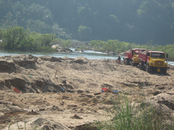
Figure 1: Sand Mining at Ulippu along Kumaradhara River, Dakshina kannada, date: 5/12/2013
Mining from, within or near a riverbed has a direct impact on the stream’s physical characteristics, such as channel geometry, bed elevation, substratum composition and stability, in stream roughness of the bed, flow velocity, discharge capacity, sediment transportation capacity, turbidity, temperature, etc. Alteration or modification of the above attributes may cause hazardous impact on ecological equilibrium of riverine regime. This may also cause adverse impact on in stream biota and riparian habitats. This disturbance may also cause changes in channel configuration and flow-paths. The major hazards caused due to mining of sand/gravel include the following (Geological Survey of India, http://www.portal.gsi.gov.in):
- Stream habitat: Mining results in an increase of river gradient, suspended load, sediment transport, sediment deposition, turbidity, change in temperature, etc. Excessive sediment deposition for replenishment/ refilling of the pits affect turbidity, prevent the penetration of the light required for photosynthesis of micro and macro flora which in turn reduces food availability for aquatic fauna. Increase in river gradient may cause excessive erosion causing adverse effect on the biota in stream habitats.
- Riparian habitat: This includes vegetation cover on and adjacent to the river banks, which controls erosion, provide nutrient inputs into the stream and prevents intrusion of pollutant in the stream through runoff. Bank erosion and change of morphology of the river can destroy the riparian vegetation cover.
- Degradation of Land: Mining pits are responsible for river channel shifting as well as degradation of land, causing loss of properties and degradation of landscape.
- Lowering of groundwater table in the floodplain area: Mining may cause lowering of riverbed level as well as river water level resulting in lowering of groundwater table due to excessive extraction and draining out of groundwater from the adjacent areas. This may cause shortage of water for the vegetation and human settlements in the vicinity.
- Depletion of groundwater: Excessive sand mining especially in abandoned channels generally result in depletion of groundwater resources causing severe scarcity, which affects irrigation and potable water availability. In extreme cases, it may also result in creation of ground fissures and land subsidence in adjacent areas.
- Polluting groundwater: In case the river is recharging the groundwater, excessive mining will reduce the thickness of the natural filter materials (sediments), infiltration through which the ground water is recharged. The pollutants due to mining, such as washing of mining materials, wastes disposal, diesel and vehicular oil lubricants and other human activities may pollute the ground water.
- Choking of filter materials for ingress of ground water from river: Dumping of final material, compaction of filter zone due to movement heavy machineries and vehicles for mining purposes may reduce the permeability and porosity of the filter material through which the groundwater is recharging, thus resulting in steady decrease of ground water resources. The riverbed mining may be allowed considering minimization of the above mentioned deleterious impacts. The guidelines of National Water Policy of India should also be followed which states that watershed management through extensive soil conservation, catchment area treatment, preservation of forest, increasing of forest cover and construction of check dams should be promoted. Efforts shall be made to conserve the water in the catchments.
Objectives: Objective of this study is to estimate the silt yield in river basins of Uttara Kannada district.
6.3 Method:
The estimation of sediments using the empirical equation is as depicted in figure 2. The DEM and topographic maps of 1: 50000 were used to delineate the sub basin, followed by estimation of slope and drainage density.
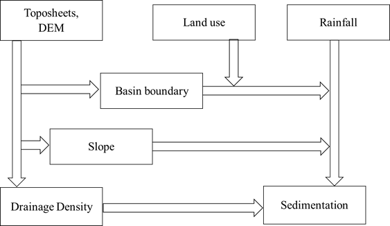
Figure 2: Method to quantify silt yield
Slope function of elevations of surrounding 8 pixels (as in figure 3) and is estimated using Horn’s equation, as
Figure 3: Kernel for deriving slope
Slope = ……..1
Where
δz/δx : Slope along x axis = [(C + 2F + I) – (A + 2D + G)]/(8*Cell size) …… 2
δz/δy : Slope along y axis = [(G + 2H + I) – (A + 2B + C)]/(8*Cell size) ……. 3
The drainage density in every sub basin is estimated as the ratio of drainage length per hectare based on the drainages delineated from the Topographic maps and DEM.
The annual sedimentation in the rive brains is estimated using the following empirical formulae
- Khoslas Equation
- Dhruva and Narayan Babu’s equation
- Garde and Kothyaris equation
- Average of all the three
Khoslas equation considers the total area under the river basin (A) and an erosion factor (Ke) to determine the annual rate of siltation (Vs).
…………4
Where, A is in sq.km
Ke = 0.00232
Dhruva Narayan and Babu used the data from 18 river basins in India, and obtained relation between annual sedimentation rate (Vs) and runoff in the river (R)
…………5
R is in Million Hectare meters or 10 Mega cubic meters.
Garde and Kothyari used the data from 50 small and large catchments of Indian rivers along with the hydro-meteorological, geological, physiographical, topographical characteristics to determine the sedimentation yield. The factors such rainfall (P), slope(S), drainage density (Dd), erosion factor (Ke) that is dependent upon the land use characteristics play an important role in determining the sedimentation (Vs).
……………6
Where P is the average annual rainfall; Pmax is the average maximum monthly rainfall.
6.4 Results:
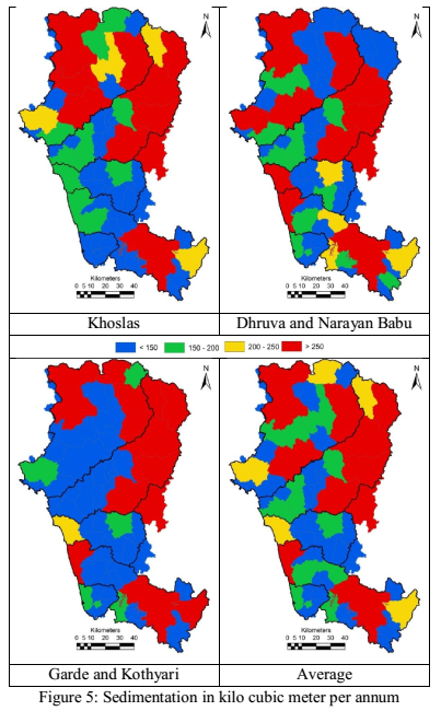
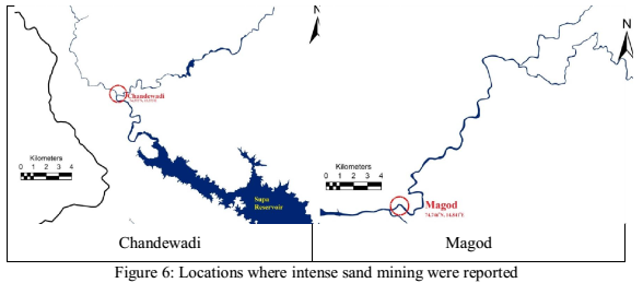
Silt yield per hectare computed as discussed in Methods section (based on 4 scenarios) is depicted in figure 4. Quantification of silt yield based on equation 6 (Garde and Kothyari) indicated lower silt yield in the Sahyadri with good vegetation cover of thick forests, forest plantations, etc. The plains due to the higher lands under irrigation and are open lands, the silt yield is comparatively higher than that of other topographic regions. Figure 5 gives the total silt yield in each sub-basin of the district. Sand mining at Chandewadi forest area (Figure 6) upstream of Supa dam of Kali river basin, as per government records is 360 kilo cubic metres per annum, whereas the estimated silt yield at Chandewadi is about 228 kilo (table1) cubic metres indicating that quantity of sand mined is more than silt yield in the respective basin. Over exploitation of sand has led to loosening of top soil along the river banks. Reports indicate that around 1100 hectare of forest land of Chandewadi is under threat due to the mining activity, that would lead to instability in soil would affect the dam (Supa). The change in land use over time has led by conversion of forest to agriculture and horticulture fields have also led to increase in silt yield, as at Magod (Figure 6) of Gangavali river basin. The silt yield at Magod in 2001 was estimated as 830 kilo cubic meters per annum (Ramachandra et al, 2001), which has increased to 1536 kilo cubic metres per annum (table 1), in 2010 due to removal of vegetation cover/forests in Bedthi basin.
Table1: Silt yield using empherical equations
Silt Yeild in kilo cum/ annum |
Chandewadi |
Magod |
Khoslas |
249.2 |
1293.6 |
Dhruva Narayan and Babu |
226.5 |
1014.5 |
Garde and Kotyari |
209.7 |
2300.2 |
Average |
228.4 |
1536.1 |

At the mouth of the river basins, the estimated silt yield is as in table 2. The sediment yield in basins such Gangavali, Sharavathi and Venkatapura, is very high with more than 6m3/Ha/year, the annual silt yield is very high in Gangavlai river basin of 2500 x 103 m3/year, Agnashini and Venkatapura are the lowest with less than 1000 x 103 m3/year.
Table 2: Sedimentation at mouth of the river basins
River Basin |
Area Ha |
Annual Silt Yield |
103 m3 |
m3/ha |
Kali |
508593 |
2345 |
4.61 |
Gangavali |
393573 |
3056 |
7.76 |
Agnashini |
144877 |
900 |
6.21 |
Sharavathi |
304271 |
2180 |
7.16 |
Venkatapura |
45969 |
360 |
7.83 |
Impacts of Sand Mining: Sand mining has an adverse and destructive impact, at the same time it has some positive impacts also, if the amount extracted is less than the quantity of silt yield per annum. Field assessment reveals that the removal of sand from the riverbeds has exceeded the natural replenishment, making it unsustainable.
Taking into consideration the places of occurrences of the adverse environmental impacts of river sand mining, Kitetu and Rowan (1997) classified the impacts broadly into two categories namely Offsite impacts and Onsite impacts. The offsite impacts are, primarily, transport related, whereas, the onsite impacts are generally channel related. The Onsite impacts are classified into Excavation impacts and water supply impacts. The impacts associated with excavation are channel bed lowering, migration of excavated pits and undermining of structures, bank collapse, caving, bank erosion and valley widening and channel instability. The impacts on water supply are reduced ground water recharge to local aquifers, reduction in storage of water for people and livestock especially during drought periods, contamination of water by oil, gasoline and conflicts between miners and local communities. The depletion of sand in the streambed of coastal region, which has caused deepening of rivers and estuaries, and the enlargement of river mouths and coastal inlets, leading to saline-water intrusion. Thus, sand mining results in the destruction of aquatic and riparian habitat through large changes in the channel morphology. Impacts include bed degradation, bed coarsening, lowered water tables near the streambed, and channel instability. In a recent study it is reported that sand mining from the Achankovil River over the past few decades has caused notable changes in the eco-biology of benthic communities (Sunil Kumar, 2002). It is well understood that mining changes the physical characteristics of the river basin, disturbs the closely linked flora and fauna, and alters the local hydrology, soil structure as well as the socioeconomic condition of the basin in general (UNEP 1990, Kundolf 1994a 1997, Padmalal 2001, Sunil Kumar 2002 and Padmalal et.al., 2003). Kundolf(1993) reported that sand mining in streams have resulted in channel degradation and erosion, head cutting, increased turbidity, stream bank erosion and sedimentation of riffle areas. All these changes adversely affect fish and other aquatic organisms either directly by damage to organisms or through habitat degradation or indirectly through disruption of food web. Effect of excessive sand and shell mining are evident from the reports of:
- Weakening of Piers of the Konkan Railway bridge across Kali River (http://www.thehindu.com/todays-paper/tp-national/tp-karnataka/illegal-sand-mining-is-posing-a-threat-to-rail-bridge-across-kali/article4008219.ece)
- At Tamilnadu, Karnataka , depletion of groundwater, lesser availability of water for industrial, agricultural and drinking purposes, destruction of agricultural land, loss of employment to farm workers, threat to livelihoods, human rights violations, and damage to roads and bridges
(http://www.narmada.org/related.issues/kali/workshop/sand.mining.dossier.doc.).
- This illegal sand mining is leading to a loss of revenue to the tune of at least Rs. 10 crores (www.narmada.com).
- Endangered the estuary area: Sea erosion has intensified in Shiriya Kadappura area due to the sand mining and even the sea walls are being engulfed by the sea. (http://thecanaratimes.com/epaper/index.php/archives/10779).
- Illegal sand mining has contaminated well waters and has turned them saline, contaminating agriculture fields.
(http://thecanaratimes.com/epaper/index.php/archives/12628).
- Coastal ecosystem is under threat losing its endemic fishes and breeding grounds, bivalves…etc.(Ramachandra et al ETR 48 )
To overcome the excessive sand mining along the river basins polices are need to be maintained, framed, and revised to restore the balance and so on. Some of the polices on sand mining includes:
- Sand mining policy of Tamilnadu
- Sand mining policy of Kerala
- Sand mining policy of Maharashtra.
- MoEF policy on minerals
And many more
Similar framework needs to be incorporated in the Western Ghats scenario to protect the ecosystem against excessive sand mining. Locations are to be identified in consultation with the hydrologists and geologists suitable for sand extraction from the river bed through the non-mechanized process. Different zonation’s with respect to the stream type and characteristics, specifying the time during which the mining is allowed followed by the strict monitoring of sediment extraction. Table 3 lists the strategies to overcome the excessive silt extraction or sand mining.
Table 3: Strategies to regulate excess sand extraction
Slno |
Strategy |
Discretion |
1 |
Creation of No Development Zones (NDZ) |
Industries needs to be classified based on their type, and polices shall be amended upon which between 500 m to 10 km either sides of the river as listed in Table 4 and CRZ 1 (Coastal Regulation Zone 1) |
2 |
Fixing of time for silt removal |
Removal of sand be permitted between 7 AM and 4 PM |
3 |
Fixing of sand removal location and quantity |
Based on category of river, sand removal shall be allowed only from the river bed, and no sand removal operation be allowed within 10 m of the river bank.
No sand removal is allowed within 500 m from any bridge, irrigation project, pumping stations, retaining wall structures, religious places, etc.
Quantity of sand extracted at particular location shall not exceed the quantity of silt yield per annum.
Weighing bridges are to be fixed at identified locations to regulate the quantity of sand extracted during a year. |
4 |
Fixing vehicle loading points |
Vehicles shall be parked at least 25 to 50 m away from the river banks, no vehicles shall be brought near the river bank.
Erecting of pillars to demarcate vehicle restriction regions, beyond which vehicle should not be allowed |
5 |
Restriction on mechanized removal |
No pole scooping or any method shall be carried out in sand removal operation |
6 |
Restriction or ban on sand removal |
Sand shall not be removed from likely places where saline waters mixes with fresh water
Sand removal quantity per year based on scientific assessment and approval of on expert committee of district
Sustainable harvesting of sand considering the yield at point of extraction
Regions such as breeding habitat of fishes and other aquatic organisms, endemic species of riparian vegetation, and basins where ground water extraction is prevalent, are to be identified in the river basins for restricting sand mining
District collector may ban sand removal in any river or river stream during monsoons, based on Expert Committee.
Based on the acts, rules and orders made by the GOI/ state the expert committee shall prepare river development plans for protection of river to keep up the biophysical environment along the river banks |
7 |
Liability of District Collector |
Fifty percent of the amount collected by the local authorities shall be contributed as river management fund and shall be maintained by the district collector. |
8 |
No construction between 500 m to 1 km from flood plain |
To protect life and property damages in cases of flash floods |
9 |
Different stretch of rivers different regulations |
Rivers are dynamic, they come across different geomorphic, climatic, sociopolitical settings. Due to this different stretches of rivers faces different issues. Rivers where rivers originate, they are at the highest purity level which needs to be maintained as it is the source contributor for the downstream. |
10 |
Flood Plain protection |
To protect against the damage that affects the floral and faunal diversity, intern maintaining the aesthetical and economic value of the river basins
No chemical based agriculture or fertilizers shall be used in the agricultural fields that affect the river channel polluting and affecting the ecosystem |
11 |
Creating awareness among the stake holders |
Very essential in order to protect the riparian vegetation, stake holders includes fishermen, dhobi’s, cattle heard’s, manufacturer’s, entrepreneurs, environmentalists etc… all of those shall be made aware of impact of their activities on the environment/ rivers |
12 |
Afforestation |
To prevent the erosion of soil
To prevent landslides along the banks of rivers |
Table 4: Class of Rivers and Allowable developments
Class of stream |
NDZ for any type of Industry |
Only Green and Orange category of industries with pollution control devices |
Any category of industries with pollution control devices |
I |
3 km on either sides of river w.r.t HFL |
3 km to 8 km from the HFL on either sides |
Beyond 8 km from HFL |
II |
1 km on either sides of river w.r.t HFL |
1 km to 2 km from the HFL on either sides |
Beyond 2 km from HFL |
III |
1/2 km on either sides of river w.r.t HFL |
1/2 km to 1 km from the HFL on either sides |
Beyond 1 km from HFL |
IV |
1/2 km on either sides of river w.r.t HFL |
1/2 km to 1 km from the HFL on either sides |
Beyond 1 km from HFL |
Industries based on type and scale are classified as red, orange and green
Table 5 compares the policy guidelines of national and international agencies. Geo scientific considerations suggested to be taken into account for sand/ gravel mining in India are (http://www.portal.gsi.gov.in/gsiDoc/pub/riverbed_mining_guidelines.pdf Geographical Survey of India):-
- Abandoned stream channels on terrace and inactive floodplains may be preferred rather than active channels and their deltas and floodplains. Replenishment of ground water has to be ensured if excessive pumping out of water is required during mining.
- Stream should not be diverted to form inactive channel,
- Mining below subterranean water level should be avoided as a safeguard against environmental contamination and over exploitation of resources,
- Large rivers and streams whose periodic sediment replenishment capacity are larger, may be preferred than smaller rivers,
- Segments of braided river system should be used preferably falling within the lateral migration area of the river regime that enhances the feasibility of sediment replenishment,
- Mining at the concave side of the river channel should be avoided to prevent bank erosion. Similarly meandering segment of a river should be selected for mining in such a way as to avoid natural eroding banks and to promote mining on naturally building (aggrading) meander components,
- Scraping of sediment bars above the water flow level in the lean period may be preferred for sustainable mining,
- It is to be noted that the environmental issues related to mining of minerals including riverbed sand mining should clearly state the size of mine leasehold area, mine lease period, mine plan and mine closure plan, along with mine reclamation and rehabilitation strategies, depth of mining and period of mining operations, particularly in case of river bed mining.
- The Piedmont Zone (Bhabbar area) particularly in the Himalayan foothills, where riverbed material is mined. This sandy- gravelly track constitutes excellent conduits and holds the greater potential for ground water recharge. Mining in such areas should be preferred in locations selected away from the channel bank stretches. Areas where channel banks are not well defined, particularly in the braided river system, midstream areas should be selected for mining of riverbed materials for minimizing adverse effects on flow regime and in stream habitat.
- Mining of gravelly sand from the riverbed should be restricted to a maximum depth of 3m from the surface. For surface mining operations beyond this depth of 3m (10 feet), it is imperative to adopt quarrying in a systematic bench- like disposition, which is generally not feasible in riverbed mining. Hence, for safety and sustainability restriction of mining of riverbed material to maximum depth of 3m.is recommended,
- Mining of riverbed material should also take cognizance of the location of the active channel bank. It should be located sufficiently away, preferably more than 3m away (inwards), from such river banks to minimize effects on river bank erosion and avoid consequent channel migration,
- Continued riverbed material mining in a given segment of the river will induce seasonal scouring and intensify the erosion activity within the channel. This will have an adverse effect not only within the mining area but also both in upstream and downstream of the river course. Hazardous effects of such scouring and enhanced erosion due to riverbed mining should be evaluated periodically and avoided for sustainable mining activities.
- Mineral processing in case of riverbed mining of the sandy gravelly material may consist of simple washing to remove clay and silty area. It may involve crushing, grinding and separation of valueless rock fragments from the desirable material. The volume of such waste material may range from 10 to 90%. Therefore, such huge quantities of mine wastes should be dumped into artificially created/ mined - out pits. Where such tailings / waste materials are very fine grained, they may act as a source of dust when dry. Therefore, such disposal of wastes should be properly stabilized and vegetated to prevent their erosion by winds,
- Identification of river stretches and their demarcation for mining must be completed prior to mining for sustainable development
- The mined out pits should be backfilled where warranted and area should be suitably landscaped to prevent environmental degradation.
- Mining generally has a huge impact on the irrigation and drinking water resources. These attributes should be clearly evaluated for short-term as well as long-term remediation.
Ministry of Environment & Forests (MoEF: http://envfor.nic.in/content/report-moef-sand-mining) also stipulates the following recommendations on mining of minor minerals/ construction materials:
- Mining Lease (ML) area should be demarcated on the ground with Pucca Pillars.
- For river sand mining, area should be clearly specified for mining operations in the region. The area should be properly surveyed and mapped with the help of GPS to assign geo coordinates and accordingly erect boundary pillars so as to avoid illegal unscientific mining.
- Within the ML area, if any forest land is existing, it should be distinctly shown on the map along with coordinates.
- While considering the sanction of ML area, due attention should be paid to the presence of any National Park/Sanctuary/Ecologically Sensitive landscape. In such cases order of the Hon’ble Supreme Court in .W.P (C) No. 337/1995) should be strictly followed.
- For mining lease within 10 km of the National Park/Sanctuary, recommendation/ permission of National Board of Wild Life (NBWL) have to be obtained as per the Hon’ble Supreme Court order in I.A. No. 460/2004.
- Site-specific plans with eco-restoration should be considered/ implemented.
As per the Ministry of natural resources and environment department of irrigation and drainage Malaysia, the following policies should be taken into consideration before approving sand and gravel mining permits:-
- Ensure conservation of the river equilibrium and its natural environment.
- Avoid aggradation at the downstream reach especially those with hydraulic structures such as jetties, water intakes etc.
- Ensure the rivers are protected from bank and bed erosion beyond its stable profile.
- Avoid interfering the river maintenance work by Department of Irrigation and Drainage (DID) or other agencies.
- No obstruction to the river flow and water transport.
- Avoid pollution of river water leading to water quality deterioration.