Amit S. Yadav, Gururaja K.V., Karthik B., Rao G. R., Vishnu Mukri, Subash Chandran M.D. & Ramachandra T.V.
1. Summary
The Western Ghats (Sahayadri Hills) of India also known as is identified as one of the richest regions in terms of biodiversity and it is often referred to as a biodiversity hotspot(Daniels, 2003). The Western Ghats is the source of 38 east flowing and 37 west flowing river systems. The ecosystem has experienced tumultuous changes due to river valley and other developmental projects in the last 60 years. Inventorying and monitoring the biodiversity and ecology of river basins would help in the formulation and implementation of appropriate conservation and management strategies in the Western Ghats. This report documents the biodiversity and ecological significance of the flood plains of Kali river basin
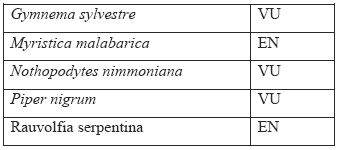
Nearly 45 endemic to Western Ghats and 73 endemic plants to both Western Ghats and Sri Lanka were recorded from the study area. Plants such as Aristalochia indica, Arundinella metzii, Canthium parviflorum, Smithia hirsuta, Flacourtia Montana, Geissaspis cristata, Crotalaria lutescens. Rhynchospora wightiana, Trees such as Artocarpus heterophyllus, Artocarpus hirsute, Caryota urens, Garcinia indica, Holigarna arnotiana, Hopea ponga, Hydnocarpus laurifolia, Ixora brachiata, Lagerstroemia microcarapa, Litsea laevigata, Mammea suriga, Mangifera indica, Memecylon talbotianum, Myristica malabarica, Polyalthia fragrans etc., are endemic to Western Ghats. Many of the plants such as Hemidesmus indicus, Cassia fistula, Pongamia pinnata, Nothopodytes nimmoniana, Embelia ribes, Rauvolfia serpentina etc., are medicinal plants. The water quality of the streams in the Kali flood plain region is in pristine condition. The Salinity level decreases gradually from the downstream to upstream in these streams. In terms of organic pollution the stream water quality was found to be good for the whole stretch. The total dissolved solids increases during the November month; it may be attributed by the excess water discharged from the paddy field during the cultivation. The phosphate and nitrate levels are recorded in very meager level. The freshwater zone of these streams supports unique stream flora and fauna, among which most are endemic odonates to Western Ghats like Euphaea fraseri, Euphaea dispar. The existing water quality also supports lot of unique aquatic organisms ranging diatoms, aquatic insects, reptiles and birds. Among the 20 species of anurans recorded, nearly 45% are endemic to the Western Ghats. The place records the presence of once thought to be extinct species of frog (Philautus cf.leucorhinus) while one of the recorded species of frog belongs to vulnerable (Philautus tuberohumerus) and three belong to near threatened category (Ramanella montana, Clinotarsus curtipes, Sylvirana temporalis ). 50 birds belonging to 13 different orders and 31 different families were recorded from the study area. One of the near threatened birds which is endemic to Western Ghats the Malabar pied hornbill (Anthracoceros coronatus) was observed in the region. Indian peafowl (Pavo Cristatus) which belongs to the Scheduled I of protected animals according to the Wild life protection act 1972 was observed in the region. Six major dams across the river, a nuclear power plant and the paper and sugar industries on its bank have already caused tremendous loss of the biodiversity in the region. Any further development be it a hydro electricity project or any thermal power plant in the district is likely to cause a lot of damage to the left over biodiversity as well as it will harm the fish production capacity of the region.
A large scale removal of mangroves in swampy area (74.18767° N, 14.88362° E) is noticed near Hankon jog within 100 meters from the flow of river. This activity is a violation of CRZ 1991 (amended in 2001) as the region falls within the prohibited activities. As per the Clause (d) of sub-rule (3) of Rule 5 of the Environment (Protection) Rules, 1986, rules 5(3)(d) of the environment (protection) rules, 1986 and also CRZ 1991, the coastal stretches of seas, bays, estuaries, creeks, rivers and backwaters which are influenced by tidal action (in the landward side) upto 500 metres from the High Tide Line (HTL) and the land between the Low Tide Line (LTL) and the HTL are mandated as Coastal Regulation Zone (CRZ). CRZ 1991 (amended in 2001) prohibits land reclamation, bunding or disturbing the natural course of sea water or dumping of ash or any wastes from thermal power stations.
This study re-affirms hottest hotspot status of the Western Ghats, a repository of biological wealth of rare kind, both in its aquatic and terrestrial ecosystems and indicates strongly the need for adoption of holistic eco-system management for conservation of particularly the rare and endemic fauna of the Western Ghats. The premium should be on conservation of the remaining evergreen and semi-evergreen forests, which are vital for the perenniality of streams and sustenance of biodiversity. Through appropriate management there still exists a chance to restore the lost natural evergreen to semi-evergreen forests. Considering the ecological significance and rich biodiversity, entire district be declared as an Eco-sensitive region as per sub section (1) with clause (v) of sub section (2) of section 3 of the Environment (Protection) Act, 1986 (29 of 1986) and clause (d) of sub rule (3) of rule 5 of the Environment (Protection) Rules, 1986 in concurrence with the provisions of the Indian Forests Act, 1927 (16 of 1927) and Forest (Conservation) Act, 1980 (69 of 1980) the Wildlife (Protection) Act, 1972 (53 of 1972) and also Biological diversity act 2002.
Ecological status of an area is determined by assessing the biodiversity of a region, the environmental conditions prevailing there and their interaction. It represents the overall health and sensitivity of an ecosystem. Ecological status assessment becomes essential for arriving at an appropriate conservation and sustainable management strategies. This assessment is done by evaluating the components along with its functional abilities of an ecosystem. This includes the assessment of species diversity, their abundance, and threats to their habitat by anthropogenic activities (like mining, dam construction, making of road or railway lines, spread of gas pipelines, building of an industry) which may alter the physical, chemical and biological integrity of the system (Ali et al, 2007, Ramachandra et al, 2006). An attempt has been made to assess the ecological status of flood plains of Kali river in the Central Western Ghats, India considering bioindicators, assessment of water quality and land cover.
Birds serve as a good ecological indicator as they inhabit almost every kind of habitat, they are at the top of food chain and thus vulnerable to bioaccumulation of toxic chemicals, they have representatives feeding on full range of animal diets (from insectivores to frugivores). For a healthy number and range of species a diverse ecosystem is needed, a lower number than expected number or range of species in an environment indicates poor ecological diversity. Amphibians are typically living at the interface between terrestrial and aquatic habitats. They are the only vertebrate group with dual life stages (i.e., tadpoles and adults) and considered as biological indicators for their sensitivity and response to very small changes in the surrounding environment. New species are discovered at much higher rate in the past two decades, paradoxically, they are on decline globally. Habitat destruction and overexploitation are the major threat for amphibians, apart from Chytrid fungus and other synergistic effects of human induced changes. Considering these aspects, it was felt that monitoring amphibian diversity and their distribution would provide an insight on the prevailing conditions of an ecosystem and its health, which in turn helps in prioritizing the region for immediate conservation and management action in the Western Ghats, India.
2.1 India - A Mega Diversity Country: Glance of biodiversity
A region with vast reservoir of floral and faunal diversity is often referred as hotspots of biodiversity. The presence of two of the worlds biodiversity hotspots in the vast terrain makes India one of the top 10 mega diversity countries in the world. Indias biodiversity constitut e 7% of the worlds flora and 6.5% of the fauna spread in the 10 biogeographic areas namely Trans- Himalaya, Himalaya, Desert, Semi Arid, Gangetic Plains, Western Ghats, Deccan Plateau, Coast and Andaman and Nicobar Islands. (Jafar and Rehman 2008). There are about 614 species of amphibians and reptiles, 1225 species of birds and 350 species of mammals in India. Among which 173 species of mammals, 75 species of birds and 208 species of reptiles are considered threatened. With 1.0287 billion populations (year 2001) the human density of India reached 325 individuals per square kilometer (21.3 % rise from the previous year), the population of India is projected to be between 1.4 to 1.5 billion by the year 2050. With this rapid increase in population the pressure on the natural resources is bound to increase at the same time for the sustenance of life conservation of the natural resources should also be given a priority. The large demand for the land and the socio economic issues is posing challenges in declaring an area as protected. Hence, the focus now is to protect the areas with high biodiversity or which are inhabited by rare or threatened organisms, or have unique habitat or under threat to destruction.
2.2 Western Ghats: Hottest Hotspot of Biodiversity
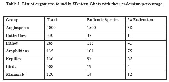
The Western Ghats, is a chain of mountains, stretching north south along the western peninsular India for about 1,600 km, harbours rich flora and fauna is one among 34 global biodiversity hotspots (Myers, et al., 2000, Sreekantha et al., 2007). Various forest types such as tropical evergreen, semi-evergreen, moist and dry deciduous and high altitude sholas mingle with natural and manmade grasslands, savannas and scrub, in addition to, agriculture, plantation crops, tree monocultures, river valley projects, mining areas and many other land-uses. Over 4,000 species of flowering plants (38% endemics), 330 butterflies (11% endemics), 289 fishes (41% endemics), 135 amphibians (75% endemics), 156 reptiles (62% endemics), 508 birds (4% endemics) and 120 mammals (12% endemics) are among the known biodiversity of the Western Ghats (Daniels, 2003., Babu, et al., 2004., Dahanukar et al., 2004., Gururaja, 2004., Sreekantha, et al., 2007). Table 1 lists the number of organisms found in Western Ghats with their endemism status.
This rich biodiversity coupled with higher endemism could be attributed to the humid tropical climate, topographical and geological characteristics, and geographical isolation (Arabian Sea to the west and the semiarid Deccan Plateau to the east). The Western Ghats forms an important watershed for the entire peninsular India, being the source of 37 west flowing rivers and three major east flowing rivers and their numerous tributaries. The four major rivers (Kali, Bedthi, Aghanashini and Sharavathi) of Uttara Kannada district of Karnataka together account for 92 fish species. However, these ecosystems have been, experiencing tumultuous changes due to unplanned developmental activities, especially during the last century. The drainage basin of River Kali is one such biodiversity rich region in the Western Ghats of Uttar Kannada district, which has been over exploited for the production of energy.
2.3 Uttara Kannada district, Central Western Ghats: Land of local Biodiversity hotspot
Uttar Kannada is the Northern most of the three coastal districts of Karnataka state namely Mangalore, Udupi and Uttar Kannada. Uttar Kannada is one of the least populated districts of the state. According to the census of India 2001 Karnataka had a population of 52,850,562 of which 1,353,644 comes from Uttar Kannada. The district extends north south to a maximum of 180 km. and west- east to a maximum of 110 km. Lying between 13o55 -15o32 N latitude and 74o 05- 75o 05south longitude the districts covers an area of about 10,291 sq. km. of which 6502 sq.km comes under dense forest and 1305 sq.km comes under open forest. (State of forest report 2001).75.86 % of the district is covered by forest which makes it the richest forest district of Karnataka. The district boasts of its 140 km of coast line (which is the most populated part of the district) which is also producer of large amount of coconuts. Of the five National Park and twenty-one Sanctuaries present in Karnataka, Uttar Kannada has three of them respectively, namely- Anshi National Park (250 sq.km), Dandeli Wild life sanctuary (475.02 sq.km) and Attiveri Bird Sanctuary (2.23. sq.km). The district is blessed with large number of Perennial Rivers and many small seasonal hill streams which make the fresh water supply to the district apart from being home to many of the aquatic organisms like diatoms, fishes, bivalves, and crabs etc. which make the livelihood of a large proportion of the coastal population. Kali, Gangavati-Bedthi, Aghanashini and Sharavathi are the west flowing rivers perennial rivers of Uttar Kannada which merge in Arabian Sea while Varada River flows eastwards and joins the Tunga River. Sixty percent of the Western Ghats (one of the 34 biological hotspots of the world) lies in Karnataka of which a large chunk is situated in Uttar Kannada District. Sreekantha et al (2007) reported two new species of fish from the genus Schistura Mcclelland in the southern most river (Sharavati) of the district. The tropical climate of Uttar Kannada has well defined monsoon period from June to October. The few localities towards coast line experience annual precipitation of 500 cm while the eastern parts may have the precipitation just above 100 cm with the average rainfall over the district being 250 cm. The winters are not that severe but summers are dry and very humid.
The primary cause of the decay of biological diversity in Uttar Kannada is the habitat destruction that inevitably resulted from the expansion of human population and human activities. Bombay gazetteer (1883) mentions of more or less dense forest growth in the hill tops, slopes and many of the Karwar valleys. The best forests were on the slopes and in the valleys facing the Kali river. However large areas of coastal forests have vanished with remnants of scrub lands. Little interior hills are covered with highly disturbed stunted deciduous forests revealing their massive exploitation by industries. Huge mangrove areas which had earlier covered the Kali estuarine areas and backwaters until Kadra or even further are now isolated in small patches except in some areas such as Kanasgeri, Asnoti and Hankon. Hankon has one of the finest and large mangrove vegetation with large trees of Sonneratia ceseolaris and Avicinnia officinalis reaching a height of 15 m. Mangroves are extremely important breeding grounds and feeding areas for shrimp and fish. Despite their great economic value, mangroves are often cleared for rice cultivation and commercial shrimp and prawn hatcheries, particularly in South- East Asia, where as much as 15% of the mangrove areas have been removed for aquaculture. Mangroves have also been severely degraded by over collecting wood for fuel, particularly charcoal production, construction poles, and timber through the region. Hence in the face of dwindling mangrove vegetation, and the surrounding forest vegetation, the study on t mangroves and other coastal vegetation focus on biodiversity and conservation aspects of these threatened habitats and their vegetation.
This endeavour focuses on the assessment of the ecological status of flood plains of Kali river basin considering large scale land cover changes in recent times in the region, while highlighting the environmental legislations towards the conservation of ecologically sensitive regions.
2.4 Conservation Endeavour in India
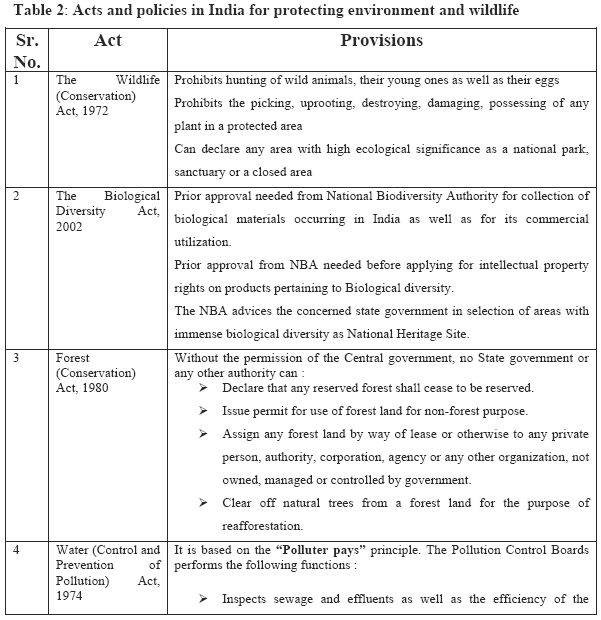
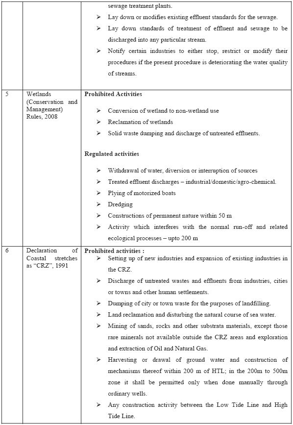
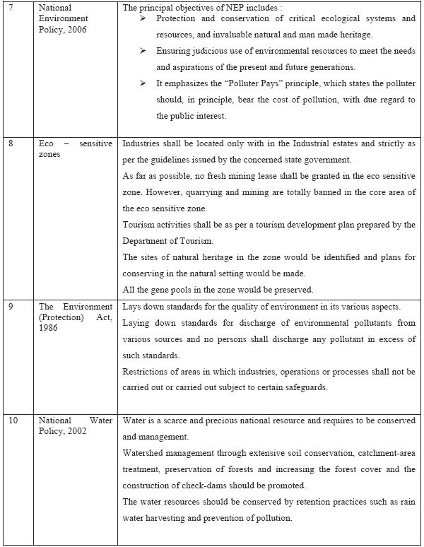
Traditionally India has a long history of conservation that is evident by the fact that India has the longest living civilization which inhabited the earth ever. The nature is worshiped in some form or the other throughout India. The 5000 year old history of civilization is a testimony of the sustainable development being practiced in India. Even legally the first conservation act came as early as 1897- The Indian Fisheries Act, followed by The Indian Forest Act- 1927, The wild life (protection) act -1972, The forest conservation act 1980 and The Environment (protection) act- 1986. The first ever national park in India was established in the year 1935 in the foothills of Himalaya now known as Corbet National Park. At present India has around 94 national park and around 502 wild life sanctuaries. The wild life protection act (1972) describes the guidelines for declaring an area as a national park or sanctuary. Conservation provisions as per the prevailing acts are listed in table 2.
As a follow up to the Convention on Biological Diversity (1993) to which India is a party among 180 odd nations, Government of India passed Biological Diversity Act 2002. Under this act every local body- a municipality or Gram Panchayat needs to have a Biodiversity management committee (BMC) which is supposed to maintain peoples biodiversity register (PBR) enlisting all the species of that area. This will help in making the biodiversity data base at the grass root level (http://wgbis.ces.iisc.ac.in/biodiversity/sahyadri_enews/newsletter/issue15/index.htm).
Biosphere reserves : The programme of Biosphere Reserve was initiated under the 'Man & Biosphere' (MAB) programme by UNESCO in 1971. Biosphere Reserves are areas of terrestrial and coastal ecosystems promoting solutions to reconcile the conservation of biodiversity with its sustainable use. They are internationally recognized, nominated by National Governments and remain under sovereign jurisdiction of the states where they are located. Biosphere Reserves serve in some ways as 'living laboratories' for testing out and demonstrating integrated management of land, water and biodiversity (http://wgbis.ces.iisc.ac.in/biodiversity/sdev/index.htm, UNESCO, 2005., IUCN, 1979). As of today 531 biosphere reserves have been setup in 105 countries all over the world of which 14 fall in Indian Territory. Each Biosphere Reserve is intended to fulfill three basic functions, which are complementary and mutually reinforcing a conservation function (to contribute to the conservation of landscapes, ecosystems, species and genetic variation), a development function - to foster economic and human development which is socio-culturally and ecologically sustainable, a logistic function - to provide support for research, monitoring, education and information exchange related to local, national and global issues of conservation and development (UNESCO, 2005; http://ces.iisc.ac.in/envis/sdev/bios.htm)
Some of the international treaties which are obligatory pertaining to ecologically fragile regions
Ramsar Convention : Under the convention on wetlands (Ramsar, Iran 1971) interest was shown by many nations in protecting the wetland ecosystem of high conservation value. As of January 2008, there are 25 Ramsar Sites in India covering 6, 77,131 ha. 135 potential sites were identified in India which can be declared as Ramsar sites. (Islam and Rahamani, 2008)
IBA : The selection of Important Bird Areas (IBAs) has been a particularly effective way of identifying conservation priorities. IBAs are the programme initiated by Bird Life International. IBAs are key sites for conservation small enough to be conserved in their entirety and often already part of a protected-area network, if significant numbers of one or more globally threatened species of birds, are one of a set of sites that together hold a suite of restricted-range species or biome-restricted species and have exceptionally large numbers of migratory or congregatory species. A site is recognized as an IBA, based on the occurrence of key bird species that are vulnerable to global extinction or whose populations are otherwise irreplaceable. An IBA must be amenable to conservation action and management. Of the 466 IBAs in India, 435 support globally threatened species, 208 have restricted range species, and 123 have biome restricted species, while 141 qualify as IBAs because they hold large congregations of water birds or migratory birds.
The ecological status assessment was carried out in the flood Plains of Kali River, Uttar Kannada district, Karnataka state, India (figure 1). The catchment basin of River Kali lies between 74deg 05 7.63 to 74deg 57 39.05 East longitude and 14deg 43 11.8 to 15deg 33 44.9 North latitude and the river basin extends over an area of 4943.43 sq. km. and covers the entire taluks of Supa, Haliyal, Karwar and partially covers the district of Ankola and Yellapur from the Uttar Kannada District. The Karwar beaches receive the water from the river. Karwar is a tourists destination famous for its long serene beaches. Karwar is the northern most coastal town of Karnataka and is also the district headquarters of Uttar Kannada. The taluk has a population of 72,852 of which majority have fishing as their source of living.
Kali river extending to a length of 184 kilometer earlier originated near the village Diggi in Supa taluk, as Karihole. The drainage network in the Kali river basin is given in Figure 2. After the construction of the dam near Supa, the entire region has disappeared and the taluk, which was once Supa, is now submerged in the reservoir. Two branches of the main stream - the Pandri and the Ujli originated in the extreme north. The two streams join at Supa, about 32 km, in the south east of the source of Pandri. Later the stream Tattihalla also joins it (the Tattihalla is a stream with a winding southerly course of about 56 km to the north of Haliyal). Near the confluence of these streams is the stepped Lalguli falls. Below its meeting with the Tattihalla, the Kali flows 16 km west where it is joined on the right by the Nujji, which originates from the southeast course of about 40 km from Goa. The Kaneri and the Vaki are its two tributaries. Kaneri originates near the village Kundal in the Supa taluk. Vaki starts near Nujji in the same taluk, takes a southeast direction and finally joins Kali near Tulasgeri. Near Kadra, Thananala (originating from Goa) joins the river. In all, the catchment area of the river is about 5,104 sq. km and the annual river discharge is 6,537 million cu. M. There are four major dam projects on this river now - the Supa reservoir near the headwaters, the Bommanhalli reservoir near the Dandeli forests, the Kodasalli dam near Ganeshgudi and finally, one at Kadra, which is the part of the Kaiga nuclear project and the other two minor dams being at Kaneri and Tattihala. The six dams together generate 1200 MW of electricity and an additional 400 MW are generated by the Kaiga power plant. The river Kali has paper mill at Dandeli which discharges a majority of its effluents into the river apart from a sugar mill which draws water from the river. Mean annual rainfall for Kali river basin from 1901-1987, is given in Figure 3. Contour of 3427 mm representing maximum rainfall are found near the coastal region and average rainfall of 2207 mm toward the centre of the basin and least rainfall of 925 mm toward the plains. The seasonality (most of the annual rain pouring down during June - September leaving the remaining months relatively dry) is caused by the moisture-laden southwestern monsoon winds encountering the steep Western Ghats, and, in contrast, the northeastern monsoon is dry. Thus, the humidity varies from 55% during dry months to 99% during monsoon months. Annual rainfall measured during the last 87 years is in the range 850 -3200 mm. Figure 4 gives the land use in the Kali river basin and the related details in Percentages is given in Table 3. The region has 35% evergreen to semi-evergreen forests.
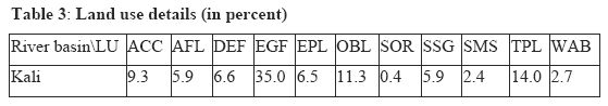
Where-Agriculture/Fallow Land: AFL, Areca/Coconut/Cashew: ACC, Exotic Plantation: EPL, Teak Plantation: TPL, Evergreen Forest: EGF, Deciduous Forest: DEF, Scrub Savannas/ Grasslands: SSG, Settlements: SMS, Open/Barren Land: OBL, Sand/Oyster/Dry River Bed/Prawn Culture/Salt pans: SOR, Water Bodies: WAB
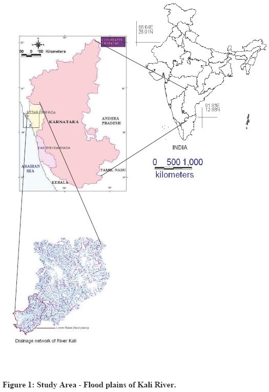
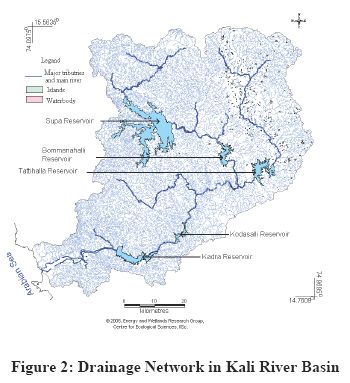
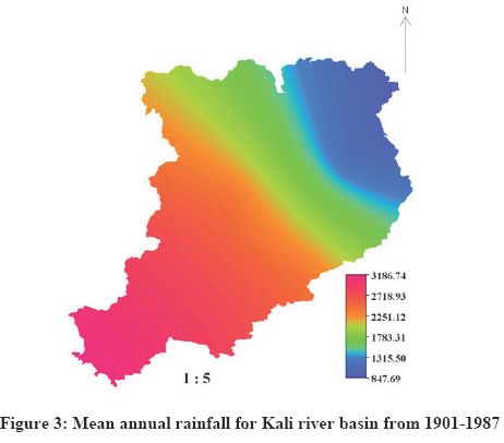
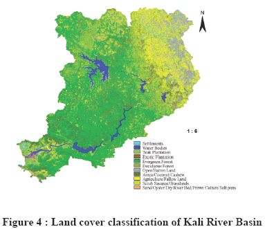
Figure 5 shows a part of Kali river as seen from Hankon village. The river records the presesnce of around 133 water birds as well as aquatic organisms. Bhat (2001) has reported an endangered fish species Horabagrus brachysoma from the River Kali near Kadra Dam. The fish has been reported only from Kali and Aghanashini basin and in the south its record comes only from Kerala skipping the two southern coastal districts of Karnataka. The place also marks the upper distribution limit for many of the endemic birds and amphibians of Western Ghats.
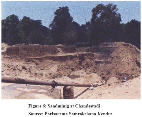
Considering the ecological status of the river Kali the proposed seventh dam near Dandeli for generating 18 MW electricity was kept in abeyance. The withdrawl of water by Bharat Sugar mills situated downstream to Dandeli was protested by local people and an NGO. (http://www.indiaenvironmentportal.org.in/node/38942). The West Coast Paper Mill established in the year 1955 having approved production capacity of 1, 19,500 tones per annum is one of the biggest polluter of River Kali. (http://www.narmada.org/related.issues/kali/workshop/wcpm.dossier.html). Figure 6 gives the evidence of illegal sand mining along the bank of River Kali.

4. Methods
To assess the ecological importance of the region, a study was undertaken covering vegetation, aquatic ecosystems, amphibians and birds:
Vegetation : Random opportunistic survey covering different habitats were visited including mangroves. The plants collected were identified according the Hookers system of classification. Rare plants were photographed and/or pressed for herbarium collection. The location of the area was recorded using a Global Positioning System (GPS).
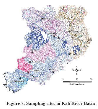
Aquatic Ecosystem : A standard method was used for water sampling. Water samples were collected in polyethylene bottles 0.5m below the surface at ten sample sites along the river stream (Figure 7) in all seasons (during 2007). All glass and plastic ware used for sampling and analyses were rinsed with distilled water. All lab measurements were performed within the threshold limit day of respective parameters. EXTECH combined electrode probe were used for determination pH, Water temperature, conductivity and Total dissolved solids, Thermo Orion Nitrates Ion Selective Electrode used for NO3 determinations, Secomam spectrophotometer were used for Phospahtes and Sulphates determinations, Systronics Flame Photometer was used for sodium and potassium determination. All reagents were analytical grade and it is supplied by the instrument makers or prepared as per the Americam Public Health Association Standard Methods. Standard methods (APHA, 1998) were used for determination of free carbon-di oxide, dissolved oxygen, alkalinity, chlorides, total hardness, calcium hardness, magnesium hardness on site and analysis of phosphates, sulphates, sodium, and potassium on lab.
Amphibian diversity : Systematic surveys were carried out in 10 sampling localities of the Kali river catchment in all seasons (during 2007-08). Visual encounters, calls, tadpoles, foam nests, spawn are used to record the amphibians in the field. Two man hours of searching is made using torch lights between 19:00-20:00 hr, by walking across the streams, forest floors, gleaning leaf litters, prodding bushes, wood logs, rock crevices etc. All the species encountered are identified up to species level (if not up to genus level) using the keys of Bossuyt and Dubois (2001) and Daniels (2005). Opportunistic encounters are also recorded to enlist the species of the region.
Bird diversity : Birds were observed from 8:00 am to 10:00 am in the morning and 4:00 pm to 6:00 pm in the evening. Birds seen or heard were recorded. An Olympus 10X 50 binocular was used and Field guide for Birds of Indian Subcontinent was referred for identification of birds.
5. Results and Discussion
Hill tops, slopes and many of the Karwar valleys were covered with a more or less dense forest growth (Bombay gazetteer, 1883). The best forests were on the slopes and in the valleys facing the Kali River. The study area (flood plains of Kali) falls within 25 km from the boundary of Anshi Dandeli Tiger reserve (which is the third for the state of Karnataka). Anshi Dandeli Tiger reserve is spread over an area of approximately 825 sq. km and encloses Anshi National park (250 sq. km) and Dandeli Wild Life Sanctuary. Black Panther a melanistic variety of leopard (Panthera Pardus) has also been reported from this region (Unpublished record). A group of Hanuman Langur (Semnopitheaus entellus) was observed near to the Hankon Village.
The different types of vegetation covered during the study include Coastal interior vegetation belt, tropical moist deciduous forests, tropical semi evergreen forests, tropical evergreen forest, scrub land, grass land, wetlands, and wasteland and open fields. Now large areas of coastal forests have vanished with remnants of scrub lands. Little interior hills are covered with highly disturbed stunted deciduous forests revealing their massive exploitation for fuel wood, grazing and timber. Huge mangrove areas which had earlier covered the Kali estuary and backwaters up till Kadra or even further are now isolated in small patches except in some areas such as Kanasgeri, Asnoti and Hankon. Hankon has one of the finest and large mangrove vegetation with good population of large trees such as Avicinnia officinalis and Sonneratia ceseolaris reaching to a height of 15 m.
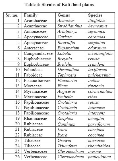
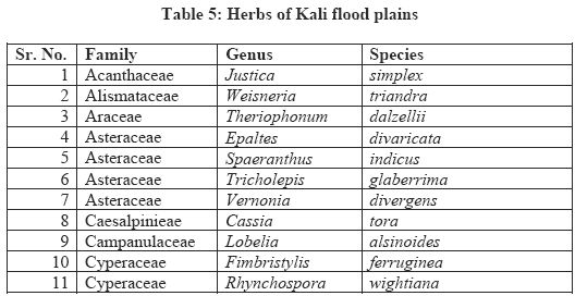
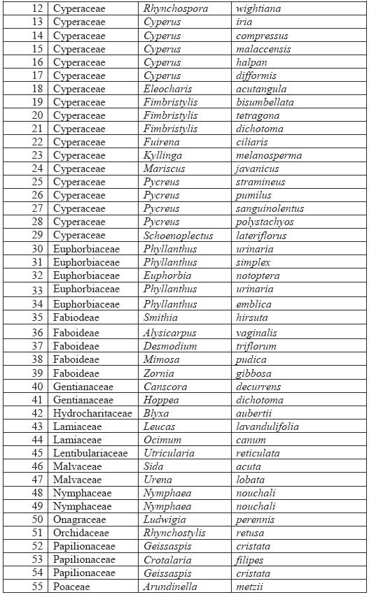
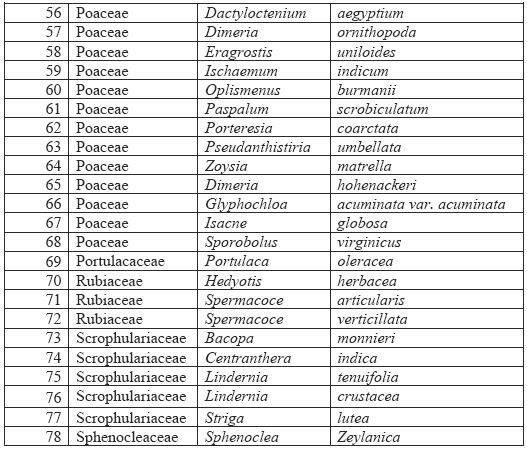
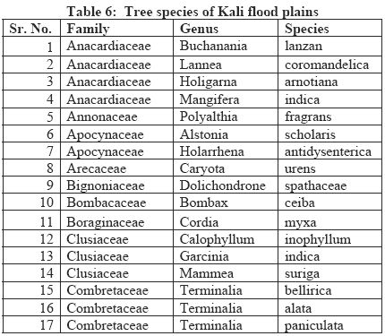
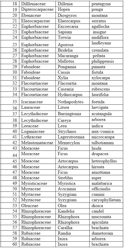
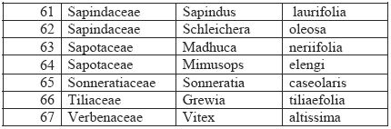
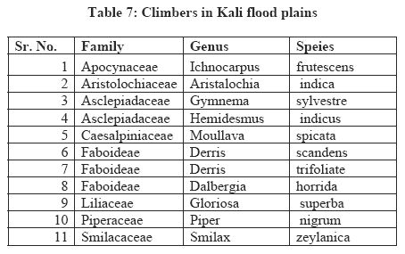
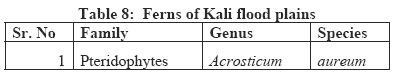
From the opportunistic study of vegetation from the area, one species of fern, 78 species of herbs belonging to 23 families, 26 species of shrubs belonging to 15 families, 11 species belonging to 8 families of climbers, and 67 species of tree from 33 families were recorded (tables 4,5,6,7 and 8). Table 4 lists shrubs, Table5 lists herbs, Table 6 lists trees, Table 7 lists climbers and Table 8 lists fern found during the sampling. Some of the rare and threatened plants from the study area are listed in Table 9.
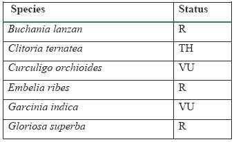 Table 9: Some of the rare and threatened plants:
(R-Rare, TH- Threatened, R-Rare, VU- Vulnerable,
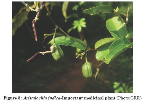
EN-Endangered (Red data list, FRLHT priority list)Nearly 45 endemic to Western Ghats and 73 endemic plants to both Western Ghats and Sri Lanka were recorded from the study area. Plants such as Aristalochia indica (Figure 8), Arundinella metzii, Canthium parviflorum, Smithia hirsuta, Flacourtia Montana, Geissaspis cristata, Crotalaria lutescens. Rhynchospora wightiana, Trees such as Artocarpus heterophyllus, Artocarpus hirsute, Caryota urens, Garcinia indica, Holigarna arnotiana, Hopea ponga, Hydnocarpus laurifolia, Ixora brachiata, Lagerstroemia microcarapa, Litsea laevigata, Mammea suriga, Mangifera indica, Memecylon talbotianum, Myristica malabarica, Polyalthia fragrans etc., are endemic to Western Ghats. Many of the plants such as Hemidesmus indicus, Cassia fistula, Pongamia pinnata, Nothopodytes nimmoniana, Embelia ribes, Rauvolfia serpentina etc., are medicinal plants.
5.2 Mangrove destruction | TOP
|
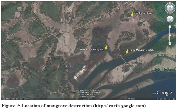
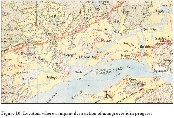
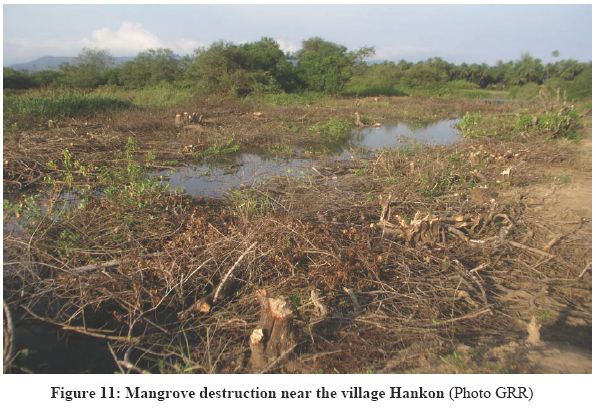
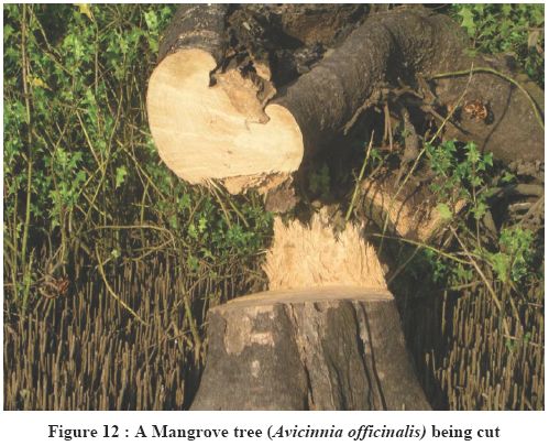
A large scale removal of mangroves in swampy area (74.18767° N, 14.88362° E) near Hankon jog was noticed. The area is a marshy land as can be seen and is well within 100 meters from the flow of river. The remote sensing image (Figure 9), toposheet (Figure 10) given below indicate the location and the scale of destruction. Authorities need to intervene immediately considering the ecological importance of mangroves (nesting site for fishes, flood prevention, protection from cyclones, tsunami, etc.). A recently chopped down tree of Avicinia of around 15 meter height (figure 11 and 12) were seen at the place. This activity is a violation of CRZ 1991 (amended in 2001) as the region falls within the prohibited activities. As per the Clause (d) of sub-rule (3) of Rule 5 of the Environment (Protection) Rules, 1986, rules 5(3)(d) of the environment (protection) rules, 1986 and also CRZ 1991, the coastal stretches of seas, bays, estuaries, creeks, rivers and backwaters which are influenced by tidal action (in the landward side) up to 500 metres from the High Tide Line (HTL) and the land between the Low Tide Line (LTL) and the HTL are mandated as Coastal Regulation Zone (CRZ). CRZ 1991 (amended in 2001) prohibits land reclamation, bunding or disturbing the natural course of sea water or dumping of ash or any wastes from thermal power stations.
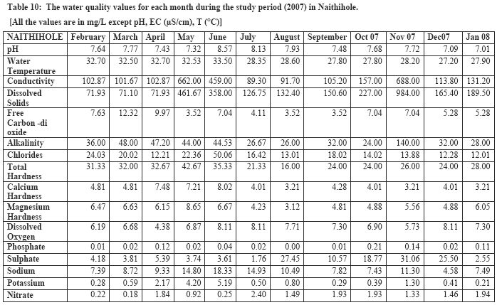
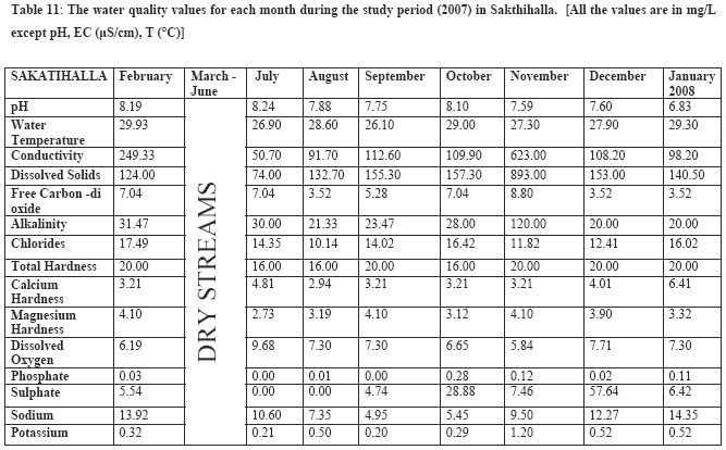
5.3 Water Quality
The water quality of the streams in the Kali flood plain region is in pristine condition. Tables 10 and 11 provide the water quality values for the monthly samples collected from two different locations in the basin. The Salinity level decreases gradually from the downstream to upstream in these streams. In terms of organic pollution the stream water quality was found to be good for the whole stretch. The total dissolved solids increases during the November month; it may be attributed by the excess water discharged from the paddy field during the cultivation. The phosphate and nitrate levels are recorded in very meager level. The freshwater zone of these streams supports unique stream flora and fauna, among which most odonates are endemic to Western Ghats like Euphaea fraseri, Euphaea dispar. The existing water quality also supports lot of unique aquatic organisms ranging diatoms, aquatic insects, reptiles and birds.
5.4 Amphibian diversity | TOP
|
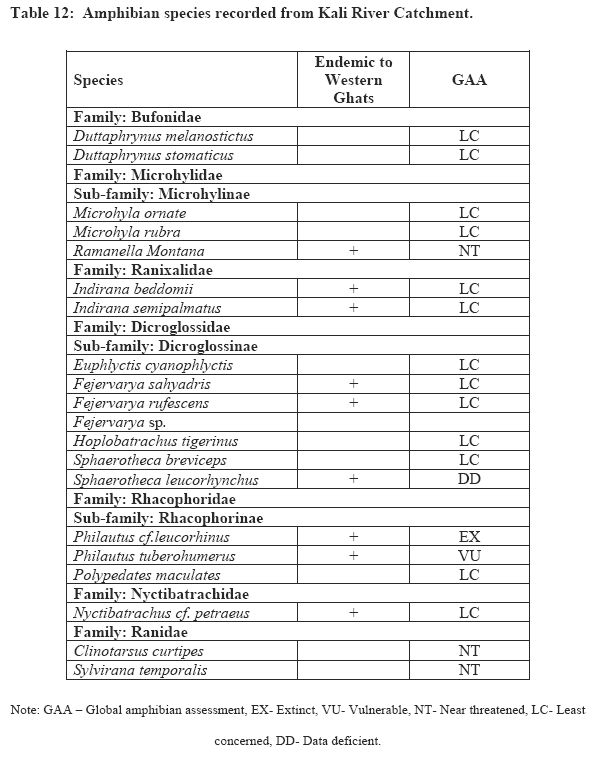
In the present study, 20 species represented by seven families were recorded in the study area. Dicroglossidae represented highest number of species (7) followed by Microhylidae (3) and Rhacophoridae (3). Table 11 depicts the species diversity in the catchment with their Global Amphibian Assessment status (GAA). Similar studies in Bedthi (33 species), Aghanashini (28 species) and Sharavathi (45 species) show higher species diversity in this region, highlighting the need for appropriate management strategies to conserve these biodiversity rich ecosystems in central Western Ghats.
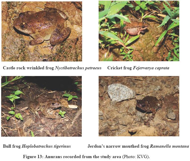
Among the 20 species recorded, nearly 45% of them are endemic to the Western Ghats. The place records the presence of once thought to be extinct species of frog (Philautus cf.leucorhinus) while one of the recorded species of frog belongs to vulnerable (Philautus tuberohumerus) and three belong to near threatened category (Ramanella montana, Clinotarsus curtipes, Sylvirana temporalis). It is interesting note that 13 species are least concerned, while only one vulnerable and three are near threatened. This could be due to prevailing dominant vegetation cover (dry-moist deciduous) providing suitable habitat for more common and generalist species. Figure 12 provides some of amphibians recorded from the area.
5.5 Avian Diversity
The survey recorded 50 birds belonging to 13 different orders and 31 different families (Table 13). Order Passeriformes dominated with 18 species followed by order Ciconiiformes and order Coraciiformes with each of them being represented by 6 species. One of the near threatened birds which is endemic to Western Ghats the Malabar pied hornbill (Anthracoceros coronatus) was observed in the region. Indian peafowl (Pavo Cristatus) which belongs to the Scheduled I of protected animals according to the Wild life protection act 1972 was observed in the region.
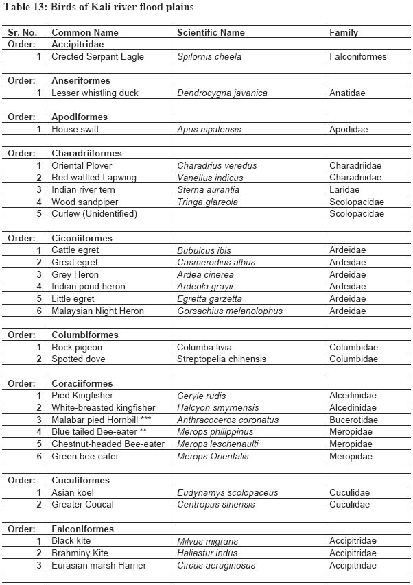
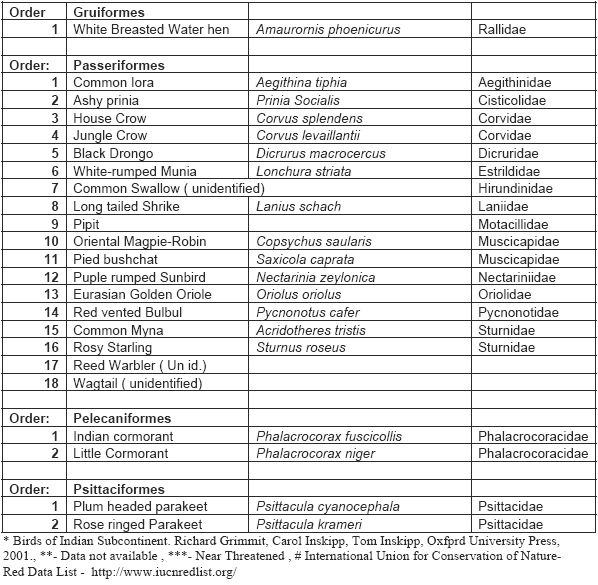
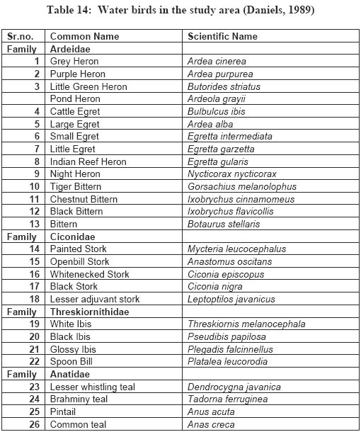
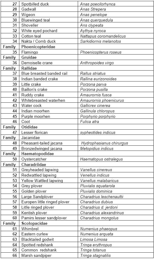
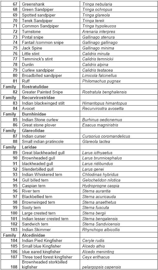
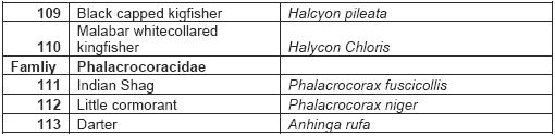
Review of literature shows that a thorough survey of bird diversity of Uttar Kannada has been done earlier by Sir Davidson (from 1890- 1895), Koelz from (1983) and Daniels (1983-1988). Biogeographically Uttar Kannada belongs to the southern Malabar of Malabar province of Oriental region. A total of 419 bird species have been recorded by Daniels et al (1990) including the contribution of Campbell, Davidson, Koelz, skin collection at BNHS and amateur bird watchers. The avifauna of Uttar Kannada represents 70 families under 18 orders. 25% of the bird taxa of the district are water birds, of which a little more are winter visitors. The major sources of water that these birds utilize are the sea, estuaries, backwaters, and the associated salt water marshes, salt pans, larger irrigation reservoirs and seasonal, vegetation covered ponds and tanks. The district also records the presence of the endangered and endemic bird from Malabar- Nilgiri wood piegeon (Columba elphinstonii) (Vulnerable C2a (ii) - IUCN). Daniels (1989) records the presence of Sandwich tern (Sterna sandvicensis) at Karwar which is an exceptional record from this part of country. He has also reported 133 water birds from Uttar Kannada (including the records of Davidson) belonging to 20 different families which inhabit estuaries, marsh land, rivers or lakes/ponds (Table 14). The lower basin of Kali River covers all these habitats suitable for these bird species.
5.6 Landscape based conservation : | TOP
|
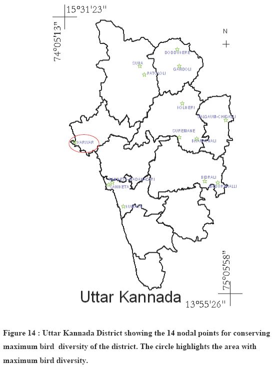
Daniels (1991,1994) have emphasized on the landscape based conservation of bird diversity in the Uttar Kannada district. The study done by Devdar et al. (2001) also highlights the need of conserving key stone habitats which maintain regional biodiversity on a priority basis for the conservation of species and management of the tropical biodiversity. As the demand for land is ever increasing conservation of large areas becomes difficult. However small patches for land representing different kinds of habitat (given the name as nodes) can be preserved to facilitate conservation of maximum bird taxa. The condition being that each node must differ significantly from other with respect to habitat type and must represent large number of bird taxa. Based on his study Daniels (1994) suggested 14 localities which can be maintained as nodes for conserving almost 80 % of the bird taxa. They are as follows-
Doddukere (L), Gundoli (L), Supa (L), Patololi (C) Kolikeri (X), Salgaum-Chigalli (L), Suremane (C) , Bharatnalli (L), Karwar (P), Saniketa-Madanagiri (R), Saniketta (R), Kumta (Z), Bidralli (C) and Madurahalli-Coodnapur (L).
[Note: the letter in parenthesis denote the habitat type of the region: C- Ever-green, L-Freshwater marsh, P- beach, R- Estuary, X- Moist deciduous forest, Z- Urban}.
The minimum area of each node is suggested to be 25 sq km for effective conservation of the habitat. Karwar showing the maximum number of water birds is the place suggested as the node for their effective conservation. Figure 14 shows the 14 nodal points identified for bird conservation .in the district (Daniels, 1994)
The six major dams across the river, a nuclear power plant and the paper and sugar industries on its bank have already caused tremendous loss to the biodiversity of the region. Any further development be it a hydro electricity project, any thermal power plant in this river basin is likely to cause a lot of damage to the left over biodiversity as well as it will harm the fish production capacity of the region.
The Uttar Kannada district with 144 km of Coast line has around 5 fishing harbors and 16- fishing centre which are famous for catching Mackerels, Sardines, Prawns and other fishes having high demand in the international market thus creating revenue for the state. The average fish catching in the district is 47800 km with inland fishing contributing an additional of 79%. Shrimp culture is also very famous activity in the coastal area. River Kali basin contributes in a major way to this fish harvest. Deterioration of in physical, chemical or biological way will certainly hamper the fish production of the place and will thus affect the lively hood of the people dependent on it.
Major projects like thermal power projects should not be implemented in the region as it would affect the forests, which in turn affect the water yield in river catchment and biodiversity of terrestrial, rivers and coastal ecosystems
The power plants, particularly those fueled by fossil or nuclear fuels, can have the most profound and wide ranging negative impacts on water quality. According to a study by Pace University, New York (2000), the following procedures occur during routine operations and maintenance of power plants and each can significantly impact water quality:
- Boiler blowdown : This waste stream results from periodic purging of the impurities that become concentrated in steam boiler systems. These pollutants include metals such as copper, iron and nickel, as well as chemicals added to prevent scaling and corrosion of steam generator components.
- Coal pile run-off : This waste stream is created when water comes in contact with coal storage piles maintained on the power plant site. While most piles are kept covered, active piles used to meet the power plants immediate needs are often open to the elements. Metals and other naturally occurring contaminants contained in coal leach out with the rainfall and are deposited in nearby water bodies.
- Cooling process wastes : Water used for power plant cooling is chemically altered for purposes of extending the useful life of equipment and to ensure efficient operation. Cooling tower blowdown contains chemicals added to prevent biological growth in the towers and to prevent corrosion in condensers.
- Boiler cleaning wastes : These wastes derive from the chemical additives intended to remove scale and other byproducts of combustion.
- Thermal pollution : The water used for cooling the thermal plants typically comes from adjacent water bodies or groundwater sources and is discharged back into the water body at significantly higher temperatures. The discharged heat can affect the aquatic organisms in either direct way by affecting their metabolism ( as most of them are cold blooded animals) or indirectly by decreasing the solubility of oxygen in the water therby depleting the amount of dissolved oxygen in water.
Impact of acid rain on vegetation: The forest soils are mostly acidic in reaction, as is characteristic of heavy rainfall tropics. The impact of release of particularly SO2 and NOX, during the rainy season, could be defoliation and forest death apart from the impact of increased acidity on soil biota, and also on crop plants.
Increased air temperature : Release of waste heat into the atmosphere is common feature of all thermal power plants. This matter is much relevant in Uttara Kannada where there are just four months of heavy rainfall and two months of light rains. The evergreen-semi-evergreen forests use the water stored in the soil for the rest of the year, and almost behave like a rain forest. In fact these forests are very sensitive to any temperature increase, as desiccation could set in and chances increase of devastating forest fires.
Flyash pollution : Flyash is the major particulate matter released into the air from coal based power plants. The surge in energy demand in south Asia, characterized by the region's dependence on coal (particularly in India), has manifest itself in major increases in airborne pollution. Urban air quality has deteriorated largely on account of growth in industrial activity, transportation needs, and energy production. Fly ash, combined with emissions from the increased use of coal, has emerged as a major environmental concern. It is also estimated that about 30-40 million tons of fly ash, (100 million according to some other studies) is generated by thermal power plants each year in India, of which a mere 2%-3% is recycled. In 1990, areas with acid loads in excess of the critical levels were in parts of northern India and Bangladesh. Recent evidence from atmospheric studies of the Indian Ocean shows high concentrations of small particles, known as aerosols, consisting primarily of soot, sulfates, nitrates, organic particles, fly ash, and mineral dust suspended over a very large area of the northern Indian Ocean, including the Arabian Sea and much of the Bay of Bengal. The studies indicate that the long-term impact of air pollution on climate through radical changes in the hydrological cycle will be widely felt throughout the region (Chatterjee et al., 2000).
Flyash impact on leaf chemistry : A study conducted on the impact of flyash generated from Shaktinagar (UP) Thermal Power Plant on leaf chemistry of Ipomea cornes, Cassia tora and Acacia nilotica, naturally growing on flyash dyke, shows that flyash severely affects the plants by changing the chemical and biochemical compositions. Protein, carbohydrates, chlorophyll and ascorbic acid decrease significantly with a significant increase of phenols (Banerjee et al., 2003). Coarse particles of fly ash affects the composition of mangrove soils and mudflats, which are indeed centres of biological productivity.
Disturbances on the mangroves : Mangroves are rated among the top ecosystems of the world in terms of productivity, ranking at par with coral reefs. Humans do not make any inputs into the mangrove ecosystem, but make heavy harvests of fish, shellfish, prawns, oysters, crabs etc from it. The minerals of the sea and the silt-laden alluvial soils brought by the rivers mingle in the mangrove swamp and make it very fertile. Constant churning of the shallow water by the tidal currents oxygenate the water, making it ideal for aquatic animals. Mangrove detritus itself forms the food for various benthic animals, which play important role in the food-web of the estuary and the coastal sea.
The key to the success of the mangroves seem to be the fine, soft and silty mud in which they grow. Mangroves grow on predominantly silty soils. A study in Taiwan shows that silt constitutes 54 to 72% of mangrove soils, and sand constitutes only less than 20% (Hseu & Chen, 1999). A greater mixture of sand or other coarse particles can alter mangrove soils and most mangroves disappear from sandy soils or from soils having rough elements in it. Mangroves grow in shallow and peaceful part of the estuaries. The mangrove soils are exposed during low tides. Therefore the key to the success of the mangroves and therefore the richness of the ecosystem lies in the nature of the soil.
Estuary mangroves in Uttara Kannada suffered in the recent times when permanent bunds were built to protect the gazni rice fields. These permanent bunds replaced the earlier earthen embankments, fortified alongside by planting of mangroves. The mangroves suffered heavily when they were totally eliminated from the very vicinity of shrimp farms. Intensive shrimp culturing began in the estuary in the late 1980s.
6. Conclusion
This study re-affirms hottest hotspot status of the Western Ghats, a repository of biological wealth of rare kind, both in its aquatic and terrestrial ecosystems and indicates strongly the need for adoption of holistic eco-system management for conservation of particularly the rare and endemic fauna of the Western Ghats. The premium should be on conservation of the remaining evergreen and semi-evergreen forests, which are vital for the perenniality of streams and sustenance of biodiversity. Through appropriate management there still exists a chance to restore the lost natural evergreen to semi-evergreen forests.
Considering the ecological significance and rich biodiversity, entire district be declared as an Eco-sensitive region as per sub section (1) with clause (v) of sub section (2) of section 3 of the Environment (Protection) Act, 1986 (29 of 1986) and clause (d) of sub rule (3) of rule 5 of the Environment (Protection) Rules, 1986 in concurrence with the provisions of the Indian Forests Act, 1927 (16 of 1927) and Forest (Conservation) Act, 1980 (69 of 1980) the Wildlife (Protection) Act, 1972 (53 of 1972) and also Biological diversity act 2002.
7. Acknowledgements
We are grateful to the Ministry of Environment and Forests, Government of India for the financial assistance to the ecological research in Western Ghats. We thank Mr.Shrikant for the assistance during the field work. People of flood plains of Kali river helped us in providing local logistics.
- Ali Sameer, G.R Rao., K. Mesta Divakar, Sreekantha, Mukri Vishnu D., M.D Subhash Chandran., Gururaja K.V., Joshi N.V. and Ramchandra T.V.(2007). Ecological Status of Sharavathi Wild Life Sanctuary. Prism Books Pvt. Ltd. Pp.1-5.
- Babu, K.K.S. and Nayar, C.K.G. A new species of the blind fish Horaglanis Menon (Siluroifea: Claridae) from Parappukara (Trichur District) and a new report of Horaglanis krishnai Menon from Ettumanur (Kottayam district), Kerala. Journal of Bombay Natural History Society, 2004, 101, 296-299.
- Banerjee, S., Singh A.K. and Banerjee, S.K, 2003. Impact of flyash on foliar chemical and biochemical composition of naturally occurring ground flora and its possible utilization for growing tree crops. Indian Forester, 129(8), 964-977.
- Bhat A.(2001). New report of the species, Horabagrus brachysoma in Uttar Kannada district in Karnataka. Journal of Bombay Natural History Society. 98(2),pp. 294-296.
- Bhat, K.G. 2003: Flora of Udupi, Indian Naturalist, Udupi.
- Bombay Gazetteer: 1883 The Bombay Presidency, Vol. XV.-Part I and Part II, Kanara; Government Central Press, Bombay, 1883.
- Chatterjee, R., Mehra, M. and Banerjee, S. 2000. Environmental security in South Asia. Indian Energy Sector.
- Cooke, T. 1903: The Flora of the Presidency of Bombay Vol. 1; Tailor and Francis, London. (Bishen Singh Mahendra Pal Singh, Dehradun
- Dahanukar, N., Raut, R. and Bhat, A. Distribution, endemism and threat status of freshwater fishes in the Western Ghats of India. Journal of Biogeography, 2004, 31, 123-136.
- Daniels R. J. R. 1989. A Conservation strategy for the birds of Uttara Kannada District. PhD Thesis, Indian Institute of Science.
- Daniels, R. J. R. and Joshi, NV and Gadgil, Madhav (1990). Changes in the Bird Fauna of Uttar Kannada, India, in Relation to Changes in Land Use over the past century. Biological Conservation. 52(1).37-48.
- Daniels R.J. R, Hegade Malati, Joshi N.V., Gadgil Madhav (1991) Assigning conservation values: A case study from India. Conservation Biology, Vol. 5, No. 4, pp. 464-475
- Daniels R. J. R. 1994. A landscape approach to conservation of birds. Journal of biosciences, 19(4), 503-509.
- Daniels, R.J.R. Biodiversity of the Western Ghats: An overview. In: Wildlife and Protected Areas, Conservation of Rainforests in India, A.K. Gupta, Ajith Kumar and V. Ramakantha (eds.), ENVIS Bulletin, 2003, 4, 25-40
- Devdar Priya, Yoganand K. and Ganesh T. (2001).Distribution of forest birds in the Andaman Islands: importance of key habitats. Journal of Biogeography. 28, 663-671.
- Gururaja, K.V. Sahyadi Mandooka: Western Ghats Amphibians, Sahyadri e-news, 2004,
http://wgbis.ces.iisc.ac.in/biodiversity/newsletter/issue6/index.htm
-
Hooker, C. B. 1885. Flora of British India. (7 volumes) International book distributors, Dehradun, India.
- Hseu, Z.Y and Chen, Z.S. 2000. Monitoring the Changes of Redox Potential, pH and Electrical Conductivity of the Mangrove Soils in Northern Taiwan. Proc. Natl. Sci. Counc. ROC(B) Vol. 24, No. 3, 2000.
- Islam M.Zafar-Ul, Rahamani Asad R (2008) Potential and Existing Ramsar Sites in India. Indian Bird Conservation Network: Bombay Natural History Society, Bird Life International and Royal Society for the Protection of Birds. Oxford University Press. Pp. 1-18.
- Myers, N., Mittermeier, R.A., Mittermeier, C.G., Da Fonseca, G. A. and Kent, J. Biodiversity hotspots for conservation priorities. Nature, 2000, 403, 853-858.
- Primack B. Richard., 1998. Essentials of Conservation Biology. Second edition, Sinauer associates, Inc., USA.
- Ramachandra, T.V., Subash Chandran, M.D., Gururaja, K.V. and Sreekantha, 2006. Cumulative Environmental Impact Assessment, Nova Science Publishers, Inc., New York.
- Saldanha, C. J. 1984: Flora of Karnataka Vol. 1. Oxford & IBH Publishing Co. New Delhi.
- Sreekantha, Subhash Chandran M.D., Mesta D K, Rao G. R., Gururaja K.V. and Ramchandra T.V. (2008). Fish Diversity in relation to landscape and vegetation in Central Western Ghats, India. Current Science, Vol. 92, No.11, Pp 1592.
- Sreekantha, Gururaja K.V., Ramadevi K, Indra T. J. and Ramchandra T.V. (2007) Two new fish species of the genus Schistura Mcclelland (Cypriniformes: Baltitoridae) from Western Ghats, India. Zoos print journal, 21(4): 2211-2216
- Talbot, W. A. 1909; Forest Flora of the Bombay Presidency and Sind. Photozincographic, Department, Poona
- Uttar Kannada Gazetteer, 1985., Government of Karnataka