Dr. T.V. Ramachandra H.S. Sudhira B. Karthick K.G. Avinash
Scope of the Study
The Bellandur Lake catchment has been subjected to extreme environmental stress mainly due to the rampant unplanned developmental activities in the catchment in recent years. Part of catchment area also falls under the Bangalore city municipal limits, which is mainly responsible for most of the sewage that flows into the lake apart from the natural storm water that drains into the lake. Of late, with the increasing pressures on land in the municipal limits, the land belonging to the lakebed has also been subjected to ad-hoc development approaches as evinced from the field investigations. The functional ability of the ecosystem is impaired due to structural changes in the ecosystem. This is evident from poor water quality, breeding of disease vectors, contamination of ground water in the catchment, frequent flooding in the catchment due to topography alteration, decline in ground water table, erosion in lake bed, etc. The development plans of the region (current as well as the proposed) ignore the integrated planning approaches considering all components of the ecosystem. Serious threats to the sustainability of the region due to lack of holistic approaches in aquatic resources management are:
- Land use changes: Conversion of watershed area of the lake to residential and commercial layouts has altered the hydrological regime while enhancing the silt movement lowering water yield in the catchment affecting the ground water recharge.
- Alteration in landscape topography: This activity is heinous, as it alters the integrity of the region affecting all biotic (all inhabitants including humans) and abiotic components of the lake catchment. This would also have serious implications on the storm water flow in the catchment.
- Poor water quality: Major portion of untreated city sewage (400+ MLD) is let into the lake thus hampering the ecological balance of the system as the quantity of the pollutant entering the lake is beyond the neutralising ability of the lake. This has lead to the enrichment of nutrients and has resulted in the lake eutrophication. The treatment units are designed for primary and secondary treatment only. This makes inorganic pollutants like NPK, will get into the lake from the treated water. With the partial treated wastewater and insufficient capacity of Sewage Treatment Plant (STP) the lake would continue to receive nutrients. As per the current plan, the treated water would be let into the lake, which is likely to get mixed with the untreated sewage as the present and proposed capacity of 248 MLD is unable to handle the citys waste water (which is about 400+MLD).
- Bellandur lake forms a part of Pennar river catchment. Water from Bellandur flows to Varthur lake which ultimately joins the Pennar river. Hence, the waste water treatment would help the downstream users as well. Apart from this, the treatment plants would provide organic nutrients. Thus the Citys wastewater could be a boon to the downstream users.
- Instead of centralised STPs authorities should plan for decentralised treatment plant in each corporation ward / zone, so that plan for reuse of water could be implemented, which would be economically viable.
- Lack of plan for treated water: Current plan for treatment design capacity is 248 MLD which is about 45% of the sewage getting into the lake. The current plan is to leave the treated water in to the lake. This would get mixed with untreated waste water, rendering the treatment exercise futile. Authorities should plan for supply of this treated water in a separate network to meet the garden and toilet requirements of the city.
- Mismanagement of municipal solid wastes: City solid wastes ranging from building demolition wastes, bulky wastes (carcasses), garbage, etc. are being dumped in the shoreline affecting the shoreline ecology, water quality and aesthetics.
- Increased population in the region is mainly due to implementation of most of the developmental projects in the city (ignoring other parts of the state) and these skewed developmental approaches have led to large scale migration. The declining quality of the city is evident from enhanced travel time (due to traffic congestions), lack of basic amenities (drinking water, electricity, etc.), decline in quality of natural resources (air, surface water, ground water, land, etc.).
1. Aquatic Ecosystems
Freshwater ecosystems provide drinking water and supply water for industry, irrigation, and hydropower. These ecosystems support complex and important food web interactions and provide habitat needed to support numerous threatened and endangered species. The area or region in which all water, sediments, and dissolved materials flow or drain from the land into a common river, lake, ocean, or other body of water is referred as a watershed, also called a drainage basin. Watershed thus is the area that drains to a common waterway, such as a stream, lake, estuary, wetland, or even the ocean -- and human actions can directly affect it.
Watershed conditions will influence the character and hydrological regime of the ecosystems. Land use changes in the form of deforestation, conversion to agriculture or other land uses removes the water-holding capacity of the soil, then soil erosion becomes more pronounced. Wetlands are important elements of a watershed because they serve as the link between land and water resources.
The quality of the region's water resources is directly linked to the quality of the watershed surrounding these waters. Understanding watershed structure and natural processes is crucial to grasping how human activities can degrade or improve the condition of a watershed, including its water quality, its fish and wildlife, its forests and other vegetation, and the quality of community life for people who live there. Knowing these watershed structural and functional characteristics and how people can affect them sets the stage for effective watershed management.
Watershed protection and management programs are most effective when natural resource management programs addresses issues such as flood control, water supply, protection of fish and wildlife, recreation, surface and ground water protection, control of storm water, point and non-point source pollution. This requires integrated approaches in watershed management to successfully manage problems for a given aquatic resource by addressing the interconnections between water resources and the land, air, and water environment surrounding the resources. The watershed approach thus includes not only the water resource, but also the surrounding land from which the water drains. This area can be as large as the Krishna River drainage basin or as small as Bellandur lake catchment.
Aquatic ecosystems provide many services and commodities to humanity. Regional lakes are integral parts of larger landscapes; their functions and values to the people in these landscapes depend on both their extent and their location. Each lake / wetland thus is ecologically unique. Wetlands perform numerous valuable functions such as to recycle nutrients, purify water, attenuate floods, maintain stream flow, recharge ground water, and also serve to provide drinking water, fish, fodder, fuel, wildlife habitat, control rate of runoff in urban areas, buffer shorelines against erosion and offer recreation to the society. The interaction of man with wetlands during the last few decades has been of concern largely due to the unplanned developmental activities based on ad-hoc approaches has lead to pollution by domestic sewage, industrial effluents and agricultural run-offs, such as fertilizers, insecticides and feedlot wastes. The fact that ecosystem values are overlooked has resulted in threats to the source of these benefits.
Lakes and Wetlands in Bangalore are increasingly facing severe urbanisation due to several anthropogenic pressures arising out of lack of vision in regional planning and implementation of the developmental activities. The rapidly expanding human population, large-scale changes in land use/land covers, burgeoning development projects and improper use of watersheds have all caused a substantial decline of aquatic resources. Significant losses have resulted from its conversion threats from industrial, agricultural and various urban developments. These have led to hydrological perturbations, pollution and there effects.
2. Urbanisation and Urban Growth | |
An urban area is defined based on the number of residents, the population density, the percent of people not dependent upon agriculture, or the provision of such public utilities and services as electricity and education. The term urban has its origin from the Roman name Urbanus which meant "city dweller" in Latin. The precise definition of an urban area can vary from country to country. Some countries define an urban area as any place with a population of 2,500 or more while some countries set a minimum of 20,000 for this criteria. In general, there are no universal standards and so each country develops its own set of criteria for distinguishing urban areas. In India, an area is designated as urban if the population is more than 5000 with a population density of more than 400 persons per sq. km and at least 75 % of the population involved in non-agricultural occupations (Census of India, 2001).
Urbanisation refers to the proportion of the total population concentrated in urban settlements, or else the rise in this proportion. It is argued that since urbanisation would account for the total population composed of both urban and rural, the proportion urban is a function of both of them. Accordingly cities can grow with out urbanisation provided the rural population grows at an equal or greater rate. Urbanisation, as such, is not seen as a threat to the environment and development. It is the unplanned urbanisation and urban growth, or the sprawl that affects the land-use of any region prone to extensive urbanization with loss of prime agricultural lands. Any loss of arable lands, ecologically sensitive habitats owing to urbanisation is irreversible and detrimental to the economy and environment in the long run. It is thus imperative to study and bring out the intricacies and implications associated with the problem of unplanned urban growth or the sprawl on the ecosystem.
The process of urbanization is fairly contributed by ruralurban migration leading to the higher proportional population growth of urbanrural and infrastructure initiatives, resulting in the growth of villages into towns, towns into cities and cities into metros. In India, today, already 28% of the population live in urban areas, with urban population growth of 3% as against the total population growth at 1-2%. The cities are expanding like never before, with inadequacies in facilities for transportation, water supply and sanitation, energy demands, etc. With a moderate economic activity and large populations in unorganised sectors of employment and inadequate housing the rise of slums and squatters in urban areas seem inevitable.
Typically the planning machinery and administrators are less equipped to address the issues of sprawl. Furthermore, with the imbalanced economic activity in practice by the government towards urban and rural economies, the rural urban migration is on the rise. The city planning is mostly addressed at catering to the future projected population and the facilities the civic authorities need to cater for that forecast of population, which are normally a static master plans or development plans.
Proper implementation of Master Plans / Development Plans is a critical aspect in the regulated development of urban areas. Although 1200 master plans / development plans for important towns and cities have been prepared so far, their implementation has not been satisfactory due to a variety of reasons, which in turn have resulted in mushrooming of slums and squatters, unauthorized and haphazard development and above all environmental degradation and transportation problems within and around the urban areas. Further, the development plans / master plans are mostly documents prepared with limited forecasting capabilities without capturing the entire dynamics and are generally not responsive to dynamic problems and responsive to policy changes.
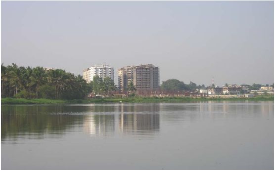
Bangalore in the recent past has succumbed to excessive population growth and uncontrolled urbanisation. According the recent census, the population in Bangalore urban district is about 65.2 lakhs (CMIE, 2000). The Bangalore Development Authority (BDA) is the nodal government agency responsible for controlling, monitoring and facilitate urban development in the Bangalore metropolitan area. The BDA has recently prepared the draft Master Plan for 2015 CE, which is a vision document for development in Bangalore metropolitan area. It has been evinced from the master plan, with the local planning area of about 1306 square kilometres, the area for development earmarked is about 786 square kilometres and the green belt and agricultural areas to be left un-urbanised is only 455 square kilometres. Further, the projected population for the metropolitan area is about 88.4 lakhs. With the prevalent rates of urbanisation taking place in Bangalore, the city has been a victim to loss of wetlands and green cover with drastic land use changes that can create ecological imbalances. Among the largest wetlands of Bangalore is the Bellandur Lake. This Lake has been subjected to more than one-third of the domestic sewage (about 400+ MLD) generated in Bangalore city is on the verge of an imminent ecological disaster. This report aims at bringing out the ecological implications of short sighted developmental activities in the Bellandur Lake catchment.
2.1. Description of Bellandur Lake Catchment
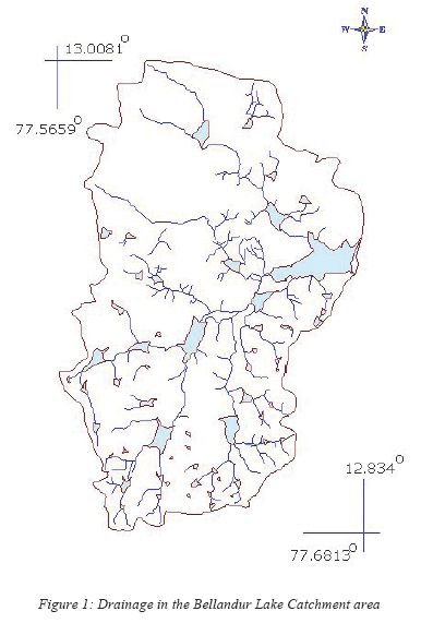
Geographically, the study area is located between 77° 35´ west and 77° 45´ east and latitude 12° 50´ south and 13° 00´ north (toposheet 57 H/9, scale: 1:50,000). The over all catchment area is about 287.33 sq. km with a water spread area of 361 ha (Water Resources Department, 2003). The terrain of the region is relatively flat and sloping towards south of Bangalore city. Relative slope of the region is found to be very gentle to gentle slope. The relative contour height is 930 m above mean sea level and the lowest is 880 m. The height is found to be 870 m above mean sea level near the tank. The drainage pattern is dendrite type and is characterized by gneiss and gneiss granite rocks. Three main streams join the tank, which form the entire watershed. One of the streams originates at the northern part of the region, Jayamahal and covers the eastern portion and is referred to as the eastern stream. Another stream originates from the central part of the city, Krishna Raja Market and covers the central part of the region before joining the tank and is called the central stream. Another stream commands southwestern part of the region called the western stream. Further, before the confluence with Bellandur Tank, all the streams come across two to three tanks (Sreekantha and Narayana, 2000). The rainfall data is available for the last 100 to 110 years. Rainfall varies from 725.5 mm to 844.8 mm. The district receives 51 % of the total annual rainfall in the southwest monsoon period, i.e. June to September. The average annual rainfall in the catchment was 859 mm in 1999. April is usually the hottest month with the mean daily maximum and minimum temperature of 33.4° C and 21.2° C respectively. December is generally the coolest month with the mean daily maximum and minimum temperature of 25° C and 15.3° C respectively. The temperature drops down to 8° C during January nights. Relative humidity is high from June to October (80 to 85 %). Thereafter, it decreases and from February to April becomes 25 to 35%. The relative humidity in the morning is higher than in the evening, giving rise to the formation of fog.
3. Environmental Status in Bellandur Lake Catchment | |
Population and Urbanisation in Bellandur Lake Catchment
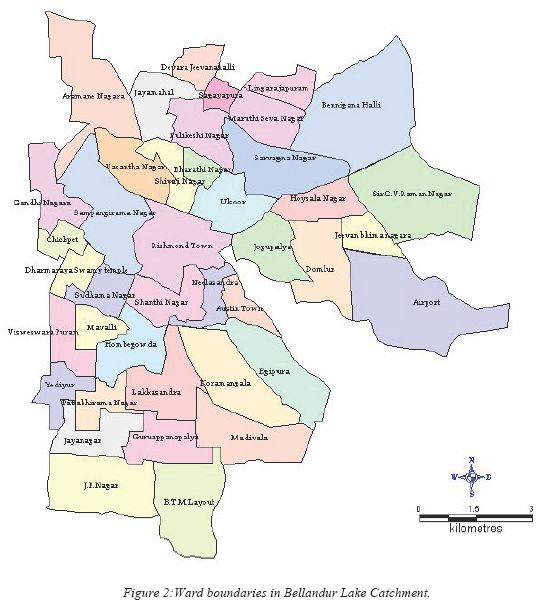
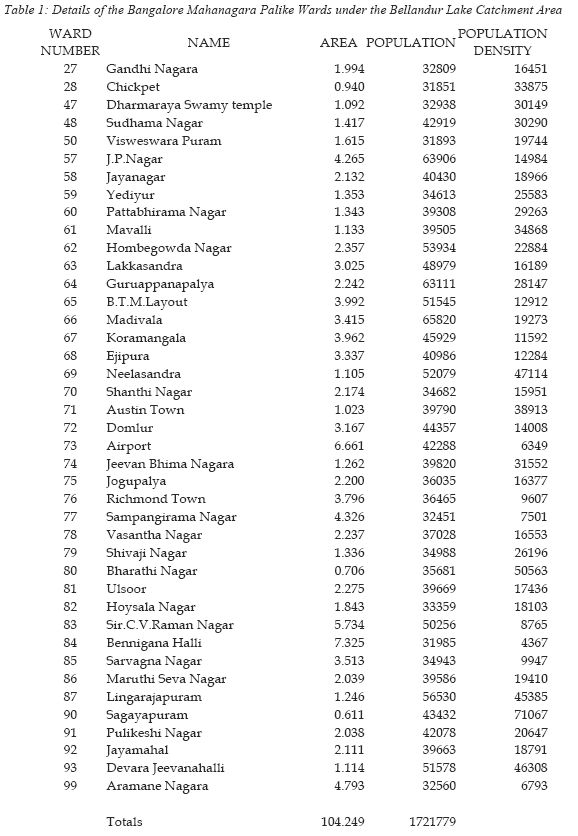
he Bellandur lake catchment area falls into almost 41 wards of the Bangalore Mahanagara Palike (the city municipal corporation). The Figure 2 shows the details of the corresponding wards that come under this catchment. It can be seen that the Bellandur Lake has to bear the natural drainage that flows into the lake from all these wards including both storm water and sewerage water. The urbanisation in Bellandur Lake catchment has been evident from the population prevalent in the region (Table 1).
It is observed that the population in the lake catchment under the municipal limits is about 1721779 persons as per the 2001 census. This is almost one-third of the Bangalore citys population for which the lake catchment is catering to. With the natural topography of the catchment sloping towards the lake in the entire catchment, any storm water run off eventually makes its way into the lake. Further, with the increased presence of urban areas in the catchment, the lake is also receiving wastewater generated in these areas that flow along the natural drainage.
Urban Water Supply and Wastewater Treatment Scenario in the Catchment
Bangalore Water Supply and Sewerage Board (BWSSB) is the nodal agency for Bangalore city to manage the water supply and wastewater collection, treatment and disposal. The water supply to the city is made possible by pumping the water from river Cauvery. The wastewater is collected according to the three important drainage basins, Hebbal valley, Vrishabhavathi and Koramangala and Challaghatta valley (K&C valley). The K&C valley essentially comprises the northern and eastern part of the Bellandur Lake catchment.
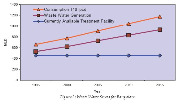
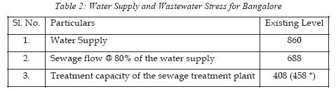
As can be seen from the table 2, the water supply at 140 lpcd for about six and half million population is about 860 MLD, while the corresponding sewage flow at the rate of 80% of water supply would amount to 688 MLD. Apparently, the prevalent wastewater treatment capacity for Bangalore is only 458 MLD. This indicates the stress on wastewater treatment in Bangalore city, with a lag of 230 MLD treatment facility for the current years population and this lag is projected to deepen for 2015 (Figure 3) unless the treatment facilities are appropriately augmented.
In the wake of such shortcomings in the sewage treatment capacities, the untreated raw sewage ends up in the storm water drains and eventually drains to the natural water bodies. Accordingly, the Bellandur Lake is also subjected to the untreated wastewater. The estimated capacity of the treatment plant at the K&C valley is about 248 MLD, while the raw sewage flow into the lake is about 400+MLD.
The sewage treatment plant (STP) set up by the Bangalore Water Supply and Sewerage Board (BWSSB), is not functional to its installed capacity and also the augmentation of the units would be unable to handle the present capacity of wastewater (about 400+ MLD, while the treatment units are being augmented is of 248 MLD). Apparently, only 30 MLD is currently operational as the 163 MLD unit is under renovation, and a 55 MLD unit is under construction. Thus of the estimated 400+ MLD of sewage that is generated in the catchment only about 30 (248 ideally!) MLD is treated and the treatment units are designed for primary and secondary treatment only. This makes inorganic pollutants like NPK, will get into the lake from the treated water. With the partial treated wastewater and insufficient capacity of STP the lake would continue to receive nutrients. As per the current plan, the treated water would be let into the lake, which is likely to get mixed with the untreated sewage as the present and proposed capacity of 248 MLD is unable to handle the citys waste water (which is about 400+MLD).
Bellandur lake forms a part of Pennar river catchment. Water from Bellandur flows to Varthur lake which ultimately joins the Pennar river. Hence, the waste water treatment would help the downstream users as well. Apart from this, the treatment plants would provide organic nutrients. Thus the Citys wastewater could have been a boon to the downstream users.
Currently, sewage ends up into the lake rendering the lake unfit for many aquatic life forms to sustain life. In order to ascertain the magnitude of the pollution load on the lake due to the domestic wastewater a water quality analysis was carried out.
| Bellandur Lake Water Quality Analysis | |
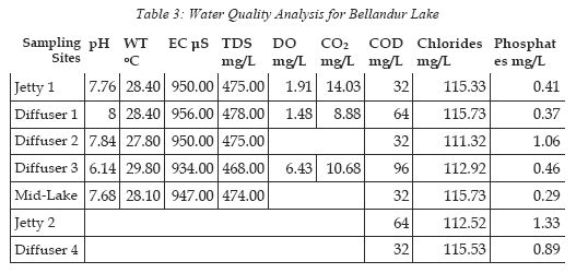
The water quality analysis was carried out for the following parameters at various locations within and around the lake. The details of the same are as in Table 3 below.
The water quality analysis revealed the following:
- The lake water is slightly alkaline
- There is high amount of dissolved solids, which includes Phytoplankton (Euglenophyceae members), calcium ions, bicarbonates, chlorides, P, N, other ions and resulting in an increased Turbidity of more than 100 NTU
- The lake water has very less Dissolved Oxygen. This may be attributed due to high organic waste from Sewage and high algal growth
- The lake is also found to have high amount of COD. This high concentration is attributed to the presence of organic matter (from the raw sewage)
- The chlorides are also found to be significant although less than the standards (IS: 10500). The presence of chlorides may due to the faecal contamination and effluent/ sewage discharge into the lake
- High phosphates in the lake may be due to detergents
Solid Waste Disposal in the Catchment
Mismanagement of city solid waste is evident from indiscriminate dumping of municipal waste (garbage), bulky waste (animal carcasses), poultry farm wastes, building demolition wastes on shoreline of the lake. As per the reports, private contractors (identified by the City Corporation for collection of municipal wastes) are responsible due to lack of vigilance by the regulatory authorities.
Land Use Changes in the Catchment
The land use changes in the catchment have been studied using a combination of the satellite remote sensing data and field investigations. From the remote sensing data for the years 1973 (Landsat MSS), 1992 (Landsat TM) and 2000 (Landsat ETM+), the false colour composites (Figure 4) were created to visually interpret the land use changes. It can be seen from Figure 4, the magnitude of land use changes in the region. In the 1973 data, the network of tanks was well connected with each other the vegetation (seen in red) prevailed along the drainage linking these tanks. By 1992, with urban sprawl extending outwards, these are seen to diminish. However, in the recent data of 2000, the entire catchment is almost succumbed to urban sprawl. This is evident from the disappearance of the water bodies, vegetation across the drainage and the drainage itself. It can also be seen that the urban sprawl has now extended up to the south west of the Bellandur Lake especially in the region in and around Madiwala, Koramangala and Ejipura. Apparently, these wards, Madiwala, Koramangala and Ejipura are also the hub of immense activity for the software industry and thus have been a centre for attracting growth. At this juncture, with the loss of green spaces and effective drainage in the region, any amount of further development can be disastrous. Subsequently, with the alteration of topography especially in the lakebed by residential or commercial layout developers has affected the integrity of watershed and has severely affected the natural course of the storm water runoff. This can cause flooding in times of heavy downpour as evinced from the recent deluges in parts of Bangalore (Bannerghatta Road and JP Nagar) and Mumbai. It is thus imperative of the planning and administration to take adequate precautions from preventing any such large scale topography alterations in the catchment. Government should initiate action to penalise the individuals and agencies responsible in the heinous crime of topography alterations with immediate effect.
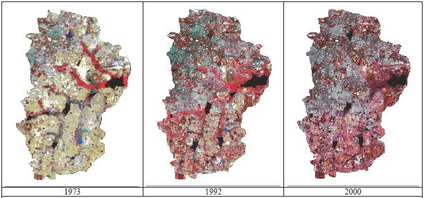
Figure 4 : False Colour Composites of Remote Sensing Data for the Bellandur Lake Catchment Area
4. Conservation of Bellandur Lake Catchment | |
At this juncture of progress, it seems very essential that a thorough introspection on the direction of development be made. This call for such introspection stems out of the fact due to the current status of Bellandur Lake catchment, which is succumbing to the urbanisation defined by the unplanned developmental activities devoid of ecosystem approaches in regional planning. While pro-development community may argue that the development has to be towards urbanisation, the indicators of urbanisation especially in terms of ecology are not favourable. On the one hand ecologists would feel imperative that the entire catchment be protected, while, developers might want to exploit the region for the simple fact that it is closer to the larger city and also enjoys proximity to key growth centres of Electronic City and Whitefield. It is not that development per se is itself questioned. But, the suggestion that development has to be based on proper integrated planning in a holistic manner acknowledging the feedbacks that might occur due to any intervention in the natural system is stressed here.
The Bangalore Development Authority (BDA) has recently prepared the draft master plan of Bangalore city for 2015. A preliminary review of the draft master plan suggests that the BDA has earmarked some of these localities as green spaces (as is situation) while some of these are also earmarked for further development. It is noted here that any further development can lead to ecological imbalance in the system, which can be disastrous. Such indications of development depicting the lack of any holistic approaches would be largely unplanned and a futile attempt. In this regard, some of the implications of the unplanned development in the Bellandur Lake catchment are discussed below.
Implications of Unplanned Development in the Bellandur Lake Catchment
Rampant Urbanisation along the Catchment :
- Land use changes : Conversion of watershed area of the lake to residential layout has altered the hydrological regime. This has impaired the sustained water yield in the catchment apart from lowering ground water recharge and enhancing silt movement in the catchment.
- Loss of Drainage Network : Rampant urbanisation in the catchment area has resulted in the loss of drainage networks. The erstwhile drainage networks were effectively catering to the storm water runoff. With the prevalent urbanisation, these are now carrying the domestic wastewater. At certain places, the courses of these drainage networks are altered to suit the construction activities. With such alteration and loss of these drainage networks, during heavy downpour, there are no mechanisms for the excessive storm water to drain and thus the water stagnates flooding in the surroundings itself. These flooded waters apart from carrying the storm water runoff would also carry the domestic sewage.
- Alteration in landscape topography : This activity is heinous, as it alters the integrity of the region affecting all biotic (all inhabitants including humans) and abiotic components of the lake catchment. This would also have serious implications on the storm water flow in the catchment.
The dumping of construction waste along the lakebed has altered the natural topography thus rendering the storm water runoff to take a new course that might get into the existing residential areas. Such alteration of topography would not be geologically stable apart from causing soil erosion and lead to siltation in the lake.
- Loss of Shoreline : The loss of shoreline along the lakebed results in the habitat destruction for most of the shoreline birds that wade in this region. Some of the shoreline wading birds like the Stilts, Sandpipers; etc will be devoid of their habitat forcing them to move out such disturbed habitats. It was also apparent from the field investigations that with the illogical land filling and dumping taking place in the Bellandur lakebed, the shoreline are gobbled up by these activities.
Disposal of Domestic Wastewater into the Lake :
- Degradation of Lake Water Quality: With the excessive disposal of domestic wastewater up to the magnitude of about 400 MLD, the lake is severely polluted as also evinced from the water quality analysis. The loss of water quality will render the lake water unfit for any usage (drinking, irrigation, etc.). The high nutrient load can also gives rise to the weeds like Water Hyacinth that can cover a large portion of the lake. The degradation of lake water quality has severely affected the aquatic flora and fauna. This is hampering the ecological balance of the system as the quantity of the pollutant entering the lake is beyond the neutralising ability of the lake. This has lead to the enrichment of nutrients and has resulted in the lake eutrophication. As this lake forms the part of chain of lakes, the quality of lakes in downstream region is also affected.
Restoration and Conservation of the Bellandur Catchment Area
- Planning to be holistic! Ecology, Natural resources, Land use, Energy, etc. all to be considered during planning of any new residential or commercial establishments.
- Acknowledge feedbacks for each and every key variable from resources to energy and economics.
- Stringent legislations have to be passed barring other municipal bodies to authorise for any medium and large-scale development activity.
- Along with the legislations is the equally effective enforcement of the same. Any lapses in the enforcement of such legislations can have serious implications in the long run.
BWWSB, 1996. Hand Book Statistics. No. BWSSB/DDS/SB-6/95-96. Bangalore Water Supply and Sewerage Board, Bangalore.
BWWSB, 2005. Sewerage Treatment, BWSSB Website. Available Online: http://www.bwssb.org/sewerage_treatment.html Last accessed: 7th September 2005.
Sreekantha and K. P. Narayana, 2000. An overview of human activities polluting Bellandur tank in Bangalore. Paper presented during Lake 2000 held at Indian Institute of Science, Bangalore.
Water Resources Department, 2003. DPR for Remediation and post remediation pollution prevention project for Bellandur Lake, Bangalore. Water Resources Department (Minor Irrigation), Government of Karnataka.