Summary
Gottigere lake with a water spread area of about 14.98 ha is located in the Bellandur Lake catchment of the South Pennar River basin. In recent years, this lake catchment has been subjected to environmental stress mainly due to the rampant unplanned developmental activities in the catchment. The functional ability of the ecosystem is impaired due to structural changes in the ecosystem. This is evident from poor water quality, breeding of disease vectors, contamination of groundwater in the catchment, frequent flooding in the catchment due to topography alteration, decline in groundwater table, erosion in lake bed, etc. The development plans of the region (current as well as the proposed) ignore the integrated planning approaches considering all components of the ecosystem. Serious threats to the sustainability of the region due to lack of holistic approaches in aquatic resources management are land use changes (removal of vegetation cover, etc.), point and non-point sources of pollution impairing water quality, dumping of solid waste (building waste, etc.). Conservation of lake ecosystem is possible only when the physical and chemical integrity of its catchment is maintained. Alteration in the catchment either due to land use changes (leading to paved surface area from vegetation cover), alteration in topography, construction of roads in the immediate vicinity are detrimental to water yield in the catchment and hence, the sustenance of the lake. Open spaces in the form of lakes and parks aid as kidney and lung in an urban ecosystem, which maintain the health of the people residing in the locality. Identification of core buffer zones and conservation of buffer zones (500 to 1000 m from shore) is to be taken up on priority for conservation and sustainable management of Bangalore lakes. Bangalore is located over a ridge delineating four watersheds, viz. Hebbal, Koramangala, Challaghatta and Vrishabhavathi. Lakes and tanks are an integral part of natural drainage and help in retaining water during rainfall, which otherwise get drained off as flash floods. Each lake harvests rainwater from its catchment and surplus flows downstream spilling into the next lake in the chain. The topography of Bangalore has uniquely supported the creation of a large number of lakes. These lakes form chains, being a series of impoundments across streams. This emphasises the interconnectivity among Bangalore lakes, which has to be retained to prevent Bangalore from flooding or from water scarcity. The main source of replenishment of groundwater is the rainfall.
The slope of the terrain allows most of the rainwater to flow as run-off. With the steep gradients available in the major valleys of Bangalore,
the rainwater will flow out of the city within four to five hours. Only a small fraction of the rainwater infiltrates into the soil. The infiltration of water into the subsoil has declined with more and more buildings and paved road being constructed in the city. Thus the natural drainage of Bangalore is governed by flows from the central ridge to all lower contours and is connected with various tanks and ponds. There are no major rivers flowing in Bangalore and there is an urgent need to sustain these vital ecosystems through proper conservation and management measures. The proposed peripheral ring road connecting Hosur Road (NH 7) and Mysore Road (SH 17) at Gottigere lake falls within the buffer zone of the lake. This would alter the catchment integrity and hence water yield affecting flora, fauna and local people, and ultimately lead to the disappearance of Gottigere lake. Developmental activities in lake catchments, which has altered lakes ecological integrity is in violation of the Indian Fisheries Act 1857, the Indian Forest Act 1927, Wildlife (Protection) Act 1972, Water (Prevention and Control of Pollution) Act 1974, Water (Prevention and Control of Pollution) Act 1977, Forest (Conservation Act) 1980, Environmental (Protection) Act 1986, Wildlife (Protection) Amendment Act 1991 and National Conservation Strategy and Policy Statement on Environment and Development 1992. Considering 65% decline of waterbodies in Bangalore (during last three decades), decision makers should immediately take preventive measures to ensure that lake ecosystems are not affected. This report discusses the impacts due to the proposed infrastructure developmental activities in the vicinity of Gottigere tank.
Lakes and tanks have been an inherent aspect of the landscape and key ecological components aiding in invaluable ecological functions. Lake ecosystems vital functions such as recycling of nutrients, purification of water, recharge of groundwater, augmenting and maintenance of stream flow and habitat provision for a wide variety of flora and fauna along with their recreation values necessitates their sustainable management through appropriate conservation mechanisms. Failure to maintain these ecosystems will result in extinction of species or ecosystem types and cause permanent ecological damage. Lakes have played a prominent role serving the needs of agriculture and drinking water. But the burgeoning population accompanied by unplanned developmental activities has led to the drastic reduction in their numbers. The existing waterbodies are contaminated by residential, agricultural, commercial and industrial wastes/effluents. Major threats to lake ecosystems (Ramachandra, 2005) are:
- Land use changes : Conversion of watershed area of the lake to residential and commercial layouts has altered the hydrological regime while enhancing the silt movement lowering water yield in the catchment affecting the groundwater recharge.
- Alteration in landscape topography : This activity is heinous, as it alters the integrity of the region affecting all biotic (all inhabitants including humans) and abiotic components of the lake catchment. This would also have serious implications on the storm water flow in the catchment.
- Poor water quality : Major portion of untreated sewage is let into the lake in most localities thus hampering the ecological balance of the system as the quantity of the pollutant entering the lake is beyond the neutralising ability of the lake. This has lead to the enrichment of nutrients and has resulted in the lake eutrophication. Gottigere, Madivala, Agaram, Bellandur, etc. forms a part of Pennar river catchment. Water from Bellandur flows to Varthur lake which ultimately joins the Pennar river. Hence, the wastewater treatment would help the downstream users as well.
- Mismanagement of solid wastes : Solid wastes ranging from building demolition wastes, bulky wastes (carcasses), garbage, etc. are being dumped in the shoreline affecting the shoreline ecology, water quality and aesthetics.
There is an urgent need for
- Restoring and conserving the actual source of water - the water cycle and the natural ecosystems that support it is the basis for sustainable water management;
- Environmental degradation is preventing us from reaching goals of good public health, food security, and better livelihoods world-wide;
- Improving the human quality of life can be achieved in ways that also maintain and enhance environmental quality;
- Reducing greenhouse gases to avoid the dangerous effects of climate change is an integral part of protecting freshwater resources and ecosystems.
Action plan to address impending water crisis in the city are:
- Rainwater harvesting through tanks and ponds would be more economical and viable proposition, considering the acute shortage of water in many parts of Bangalore. Undulating terrain coupled with permeable soil allow optimal collection of water for use along the plateau. It is possible to improve the groundwater table, by improving waterbodies.
- The topography of the region should not be altered and large scale land use changes have to be banned in Bangalore
- Storm water drains are to be redesigned to ensure rainwater is channelled to the lakes.
- Efforts should be made to ensure that these tanks are not polluted by discharge of effluent and industrial wastes.
- Existing tanks should be deweeded and aquatic life must be developed.
- Buffer zone is to be created and maintained to enhance the water yield and hydrology of the waterbody. 500 to 1000 m across waterbody and valley zones should be declared no activity zones.
- Encroachment of lake beds is to be handled through the implementation of prevention of encroachment act.
- BWSSB should come up with appropriate action plan to collect and treat sewage and refrain from current approach of polluting waterbodies or inundate low lying open spaces. The responsibility for the maintenance of waterbodies in clean and safe conditions should be entrusted to Bangalore Water Supply and Sewage Board.
- Considering the unrealistic growth of planning, consequent to unplanned developmental activities, more open spaces are to be created in Bangalore, which can aid as lung spaces for the city. If necessary, adjoining lands should be acquired for the development of recreation spots and providing more lung spaces as well as improving ecology to attract migrating birds.
- The State should adopt disaggregated growth giving emphasis to all regions of the state than concentrating growth of Bangalore.
- Limit to growth is evident as Bangalore is experiencing the trauma of enhanced travel time, water and energy crisis, enhanced pollution levels, increased crime rates and changes in microclimate (increased temperature due to heat islands) and more importantly changes in human behaviour.
- Disused tanks in the metropolitan area could be utilised for rainwater harvesting, developing tree parks and recreational forests. Development of forest nurseries could also be taken up in such disused tanks.
- The live tanks in the metropolitan area and the green belt area provide a vast extent of land for foreshore planting. Such foreshore planting without obstructing the feeder flow channels of the tank will help to prevent silting apart from providing greenery around. In addition, the planting of trees and development of tree parks will help to prevent the encroachment of tank beds.
- Biological control of water pollution is to be taken up on priority.
- Waterbodies aid in recharging groundwater on the downstream. This will help to draft water through dug wells/borewells meant for domestic purposes. These existing tanks should not be breached but retained as waterbodies.
- Dumping of solid waste in the lake catchment and usage of plastics should be banned. Defaulters (implementers for non-action and individuals involved in polluting) should be penalised.
- The existing tanks in the periphery of Bangalore city are going dry due to mismanagement of water. Inflow channels have been altered / destroyed and sedimentation in these lakes necessitates desilting, restoration and management
Bangalore : Bangalore is the principal administrative, cultural, commercial, industrial, and knowledge capital of the state of Karnataka. Greater Bangalore, agglomerating the neighbouring outgrowth and municipal councils was notified over an area of 741 square kilometres recently. A tiny village in the 12th century, it grew to become one of the fastest growing cities in the world by 21st century and to figure among the million-plus cities in India. Bangalore has grown spatially more than ten times since 1949. Bangalore is located at 12.59º north latitude and 77.57º east longitude, almost equidistant from both eastern and western coast of the South Indian peninsula, and is situated at an altitude of 920 metres above mean sea level. The mean annual total rainfall is about 880 mm with about 60 rainy days a year over the last ten years. The summer temperature ranges from 18° C 38° C, while the winter temperature ranges from 12° C 25° C. Thus, Bangalore enjoys a salubrious climate all round the year. Bangalore is located over ridges delineating four watersheds, viz. Hebbal, Koramangala, Challaghatta and Vrishabhavathi. The undulating terrain in the region has facilitated creation of a large number of tanks providing for the traditional uses of irrigation, drinking, fishing and washing. Their creation is mainly attributed to the vision of Kempe Gowda and of the Wodeyar dynasty. This led to Bangalore having hundreds of such waterbodies through the centuries. Even in early second half of 20th century, in 1961, the number of lakes and tanks in the city stood at 262. These, and open spaces generally were seriously affected with the enhanced demand for real estate and infrastructure consequent to urbanisation.
After Independence, Bangalore, now a State capital, saw an influx of population migrating to the city, since 1941-1951. Population growth during the 1970s could be ascribed to numerous public sector industries and other defence establishments that came up during the period and fuelled significant immigration. By this time, incidentally, Bangalore had lost its tag of Pensioners Paradise, gained before Independence. Although the advent of IT is attributed to the late 1980s, major growth and expansion of this industry happened only during the late 1990s. Still, population growth in Bangalore in the last census decade, 1991-2001 (38%), was substantially less than in 1971-1981 (76%). Nevertheless, the physical growth of the city has been phenomenal over the last few years, and the glaring evidence of this is increased travel-times and the escalating real-estate prices. The City is expanding from its city centre and is growing in all directions in an irregular radial pattern. Bangalore's unplanned boom, especially during the last decade, has seen single-unit residential dwellings paving way to multi-storied apartments. These apartments, some of which have even been built in violation of norms, are on tiny plots of land. There are no vacant areas that can act as soak pits during a heavy downpour. This random and unplanned development has caused a plethora of civic and traffic problems since the existing system - roads, drainage or storm water drains - has just not been designed to take the additional load. Sewage management has been a major area of neglect. Bangalore sewage is let into lakes in many localities. Bangalore's existing underground sewerage lines on any given road were designed with a few dozen houses in mind, but with apartments springing up almost overnight, the system is just not able to cope. Discharge of sewage water into Lakes has rendered them unhealthy, ugly apart from contamination of the groundwater table. The tanks within and around the city have now become prolific sources of mosquitoes because of sewage contamination. Fresh rainwater gets polluted due to the flow of sewage and sullage in all the storm water drains. The first few showers of the monsoon rains bring in large quantity of pollutants organic matter, putrescent matter, oil spilled by automobiles, heavy metals, solid wastes, sewage and industrial effluents, leading to episodes of fish deaths.
With urbanisation in vogue, since the industrial revolution led by the fossil-fuel driven economy, has pushed for humans to adapt to different livelihood options, leaving the traditional agro-economy in despair. With traditional rural backdrop, now set to embrace the inevitable and uninvited urbanisation has also meant the transformation of these landscapes. Approaching the large scale infrastructure development projects with lack of sensitivity to landscape in general and the tanks that dot these landscapes in particular, runs the risk of depriving communities of valuable socio-ecological services and functions provided by natural systems. These tanks support peoples livelihoods in a number of ways fishing, washing clothes, groundwater recharge, recreation, etc. Some of the potential benefits to local populations from the seasoned multi-tank systems are:
- The water table remains high due to widespread percolation, and irrigation water from wells becomes more available. It is favoured by farmers for its flexibility.
- Water becomes available in larger areas and to a larger number of farms, either as flow, tank, or as groundwater irrigation.
- Land use improves as some tank beds are cultivated part of the year (petta cultivation) instead of remaining submerged.
- Non-agricultural categories of the population gain access to water: for domestic use, but also for fisheries, livestock and industries.
- Social customs and links are preserved or revived in building and maintaining traditional water-harvesting structures and in negotiating water use.
These complex socio-ecological systems have become integrated into the community in many ways, and should not be disturbed by sudden change or reversals without proper planning and analysis. Tanks in and around Bangalore are increasingly facing severe threats due to several anthropogenic pressures arising out of lack of vision in regional planning and implementation of the developmental activities. The rapidly expanding human population, large-scale changes in land use/land covers, burgeoning development projects and improper use of watersheds have all caused a substantial decline of aquatic resources. These have led to hydrological perturbations, pollution and their effects.
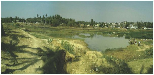
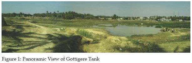
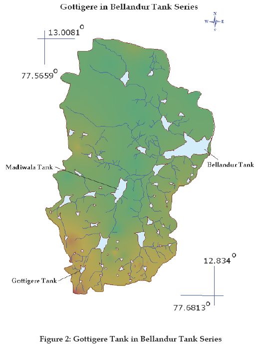
The Gottigere tank is part of the South Pennar river basin and is an important feeder tank to the Hulimavu and Madiwala tanks, which eventually feed to Bellandur and Varthur tanks. It has a water-spread area of 14.98 Ha. The location of the tank in the Bellandur tank series is depicted in Figure 1 and Figure 2, which gives a panoramic overview of the tank and the tank in Belandur watershed. The rainfall data for the region is available for the last 100 to 110 years. Rainfall varies from 725.5 mm to 844.8 mm. The district receives 51 % of the total annual rainfall in the southwest monsoon period, i.e. June to September. The average annual rainfall in the catchment was 859 mm in 1999. April is usually the hottest month with the mean daily maximum and minimum temperature of 33.4° C and 21.2° C respectively. December is generally the coolest month with the mean daily maximum and minimum temperature of 25° C and 15.3° C respectively. The temperature drops down to 8° C during January nights. Relative humidity is high from June to October (80 to 85 %). Thereafter, it decreases and from February to April becomes 25 to 35%. The relative humidity in the morning is higher than in the evening, giving rise to the formation of fog.
Conservation of Gottigere Lake | TOP
|
Gottigere lake is under pressure from large scale developmental activities, which is detrimental to its sustenance. Topography in the catchment should not be altered and a large scale land use change has to be banned for the survival of the lake. Storm water drains are to be redesigned to ensure rainwater is channelled into this lake. Efforts should be made to ensure that these tanks are not polluted by the discharge of effluent and industrial wastes. Existing tanks should be deweeded and aquatic life must be developed. Buffer zone (500 m from the shore line) is to be created and maintained to enhance the water yield and hydrology of the waterbody. 500 m across waterbody and valley zones are to be declared no activity zones. Peripheral ring road either over or adjacent to the tank will alter the ecology and hydrology of the lake and the lake catchment (up to 500 m from shoreline should not be disturbed). Two alternate alignments suggested at Gottigere, part of peripheral ring road is depicted in Figure 3. Alignment 1, passing over the tank covers significant amount of tanks surface blocking the amount of light that penetrates into the waterbody, which can have serious ecological implications (discussed below). On the other hand, the Alignment 2 passes around the tank, taking away some amount of land over the inflow to the tank. This study attempts to bring out the short-comings of both these approaches and highlights likely ecological implications on the tank.
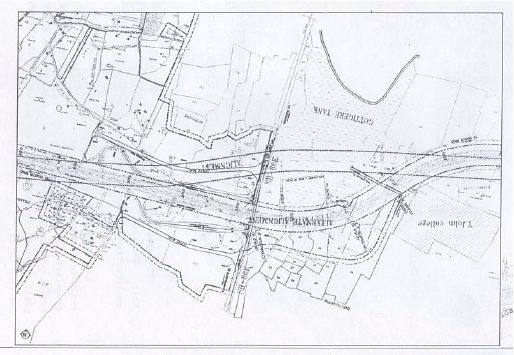 Figure 3 : Proposed Alignment of Expressway at Gottigere
Land Use Changes in the Catchment
The land use changes already initiated by the alignment of the Peripheral Ring Road (PRR) is analysed based on the satellite remote sensing data for the years 2000 and 2006. The satellite remote sensing data of Landsat ETM+ for 2000 was obtained from Global Land Cover Facility and the LISS-III data for 2006 was obtained from National Remote Sensing Agency, Hyderabad. These data were pre-processed for image geo-registration and rectification. The false colour composites (FCC) for these two time periods were created (Figure 4 and 5) to compare the land use changes through visual interpretation.
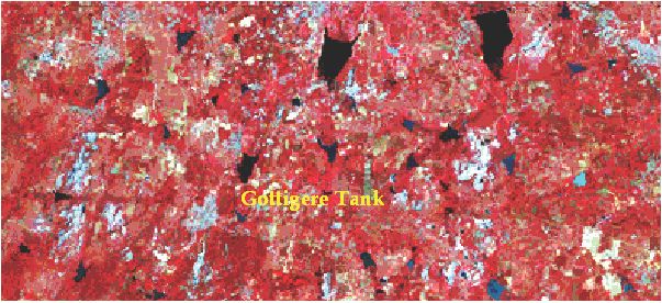 Figure 4: False Colour Composite around Gottigere in 2000
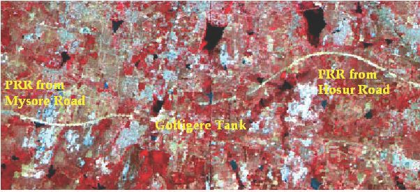 Figure 5: False Colour Composite around Gottigere in 2006
Comparative analysis of Figure 4 and Figure 5 shows the land use changes due to the construction of PRR with the increased urban (built-up) pockets in the lake catchment. Creation of ring roads around the city aids as sinks of sprawl thus implicating the change in land use significantly. Owing to poor planning practices and enforcement of the development plans, the feedbacks and implications of such infrastructure projects are not captured. As in the case of most infrastructure development projects that the city has embraced, this is yet another such project which has overlooked certain critical implications on land use and the corresponding implications on the socio-economic aspects of the people directly affected by the project and the ecological implications of the project.
The alignment of PRR over the tank affects the ecology of tank significantly by the obstruction of incident light into the water. This can have serious implications on the biological organisms especially the primary producers, which thrive on sunlight for converting the incident light into energy. Light is the factor that fundamentally determines the level of primary production. In the tank ecosystem primary productivity is controlled by bottom-up factors (nutrient levels) and secondary effects due to biological factors (zooplankton grazing). The light regiment experienced by algae is determined largely by mixing of the water column. The processes of photo inhibition and light attenuation combine with the resultant lightdark adaptation to shape the low productivity profile and it eventually ends in affecting the higher organisms in the lake food chain.
Phytoplankton and phytobenthos show large interspecific variability in terms of light (and Ultra-Violet in particular) sensitivity and tolerance. Even closely related algal species might differ considerably in their defense strategy against incident radiation (UVR, 280400 nm) (Quesada & Vincent, 1997). Changes in the incident sunlight would cause a shift in community structure and species composition (Santas et al., 1997). Beyond the species-specific resistance there are several other factors influencing the effect of incident sunlight (UVBR, 280320 nm) such as vertical mixing in the water column (Karentz et al., 1994), the duration of exposure (Villafañe et al., 1995) or nutrient supply (Lesser et al., 1994; Wulff et al., 2000). Furthermore, the reactions of photoautotrophic organisms brought about by UVR may be modulated by the level of concomitant exposure to photosynthetically active radiation (PAR, 400700 nm) as well (Beardall et al., 1997). Although most studies have focussed on UVBR, some authors pointed out that photosynthetic inhibition in the ultraviolet range in phytoplankton communities is caused mostly by UVA radiation (UVAR, 320400 nm) (Bühlmann et al., 1987; Villafañe et al., 1995; Bertoni & Callieri, 1999; Villafañe et al., 1999). In the study (Palffy & Vörös, 2003) on photo inhibition in freshwater lakes, it was found that even temporary inhibition of light using cut-off filters resulted in as much as 72-78% of surface photo inhibition. At approximately 0.5 m depth, there is maximal photosynthesis causing depletion of nutrients. Photo inhibition will result in low photosynthesis and the lake will be left with huge amounts of nutrients. The huge amount of nutrients with low sunlight will lead to eutrophication, resulting in the growth of huge mats of particular algae (mostly Blue green algae, BGA). This will result in low dissolved oxygen (DO) and high Biochemical Oxygen Demand (BOD). It is to be noted that most fish death in tanks occur due to low levels of DO. Thus, if the alignment of the PRR is to be over the tank, the resulting shading can have a considerable impact on potential primary productivity and would affect the phytoplanktoncyanobacterial community structure within the tanks ecosystem.
Restoration and Conservation of Gottigere Tank | TOP
|
This research strongly suggests that the best strategy for both irrigation authorities and donor agencies involved in infrastructure development is to view tanks as complex socio-ecological systems with multiple stakeholder groups. Instead of addressing the landscape as open resource meant only for infrastructure development, the focus should rather be on a wider, river basin or macro-watershed development and management approach leading to sustainable development. Socio-ecological systems, like living beings, subsist on complex and delicate balances between nature and various parts of the population living in the same territory. These complex socio-ecological systems have become integrated into the community in many ways, and should not be disturbed by sudden change or reversals, without proper planning and analysis. It is observed that with the completion of PRR the land use would certainly undergo drastic changes with significant implications on landscape. Further, the alignment of PRR over the tank clearly depicts the short-sightedness of the planners which can have drastic implications on the tank ecosystem itself. Yet, with these transformations, the key sufferers were and will be the people residing in the peri-urban areas and its landscape.
During recent years, the degradation of freshwater ecosystems by a variety of stressors has increased logarithmically. As a result, many aquatic ecosystems are in need of some drastic corrective measures / restoration. Restoration is the "return of an ecosystem to a close approximation of its condition prior to disturbance" or the reestablishment of predisturbance aquatic functions and related physical, chemical and biological characteristics. It is a holistic process that is not achieved through the isolated manipulation of individual elements. The objective is to emulate a natural, self-regulating system that is integrated ecologically with the landscape in which it occurs. Often, restoration requires one or more of the following processes: reconstruction of antecedent physical conditions, chemical adjustment of the soil and water; and biological manipulation, including the reintroduction of absent native flora and fauna. These principles focus on scientific and technical issues, but as in all environmental management activities, the importance of community perspectives and values is to be considered. Coordination with the local people and organisations that may be affected by the project can help build the support needed to get the project moving and ensure long-term protection of the restored area. In addition, partnership with all stakeholders can also add useful resources, ranging from finance and technical expertise to volunteer help with implementation and monitoring (Ramachandra, 2005). Restoration principles are
- Preserve and protect aquatic resources: Existing, relatively intact ecosystems are the keystone for conserving biodiversity, and provide the biota and other natural materials needed for the recovery of impaired systems.
- Restore ecological integrity: Ecological integrity refers to the condition of an ecosystem -- particularly the structure, composition, and natural processes of its biotic communities and physical environment.
- Restore natural structure: Many aquatic resources in need of restoration have problems that originated with harmful alteration of channel form or other physical characteristics, which in turn may have led to problems such as habitat degradation, changes in flow regimes, and siltation.
- Restore natural function: Structure and function are closely linked in river corridors, lakes, wetlands, estuaries and other aquatic resources. Reestablishing the appropriate natural structure can bring back beneficial functions.
- Work within the watershed and broader landscape context: Restoration requires a design based on the entire watershed, not just the part of the waterbody that may be the most degraded site. Activities throughout the watershed can have adverse effects on the aquatic resource that is being restored. By considering the watershed context in this case, restoration planners may be able to design a project for the desired benefits of restoration, while also withstanding or even helping to remediate the effects of adjacent land uses on runoff and non-point source pollution.
- Understand the natural potential of the watershed: Restoration planning should take into account any irreversible changes in the watershed that may affect the system being restored, and focus on restoring its remaining natural potential.
- Address ongoing causes of degradation: Identify the causes of degradation and eliminate or remediate ongoing stresses wherever possible.
- Develop clear, achievable, and measurable goals: Goals direct implementation and provide the standards for measuring success. The chosen goals should be achievable ecologically, given the natural potential of the area, and socio-economically, given the available resources and the extent of community support for the project.
- Focus on feasibility taking into account scientific, financial, social and other considerations.
- Anticipate future changes: As the environment and our communities are both dynamic, many foreseeable ecological and societal changes can and should be factored into restoration design.
- Involve the skills and insights of a multi-disciplinary team: Universities, government agencies, and private organisations may be able to provide useful information and expertise to help ensure that restoration projects are based on well-balanced and thorough plans.
- Design for self-sustainability: Ensure the long-term viability of a restored area by minimising the need for continuous maintenance of the site. In addition to limiting the need for maintenance, designing for self-sustainability also involves favouring ecological integrity, as an ecosystem in good condition is more likely to have the ability to adapt to changes.
- Use passive restoration, when appropriate: Simply reducing or eliminating the sources of degradation and allowing recovery time will allow the site to naturally regenerate. For some rivers and streams, passive restoration can re-establish stable channels and floodplains, regrow riparian vegetation, and improve in-stream habitats without a specific restoration project. Passive restoration relies mainly on natural processes and it is still necessary to analyse the site's recovery needs and determine whether time and natural processes can meet them.
- Restore native species and avoid non-native species: Many invasive species outcompete natives because they are expert colonisers of disturbed areas and lack natural controls.
- Use natural fixes and bioengineering techniques, where ever possible: Bioengineering is a method of construction combining live plants with dead plants or inorganic materials, to produce living, functioning systems to prevent erosion, control sediment and other pollutants, and provide habitat. These techniques would be successful for erosion control and bank stabilisation, flood mitigation, and even water treatment.
- Monitor and adapt where ever changes are necessary: Monitoring before and during the project is crucial for finding out whether goals are being achieved. If they are not, "mid-course" adjustments in the project should be undertaken. Post-project monitoring will help determine whether additional actions or adjustments are needed and can provide useful information for future restoration efforts. This process of monitoring and adjustment is known as adaptive management. Monitoring plans should be feasible in terms of costs and technology, and should always provide information relevant to meeting the project goals.
These principles focus on scientific and technical issues, but as in all environmental management activities, the importance of community perspectives and values should not be overlooked. The presence or absence of public support for a restoration project can be the difference between positive results and failure. Coordination with the people and organisations that may be affected by the project can help build the support needed to get the project moving and ensure long-term protection of the restored area (Ramachandra, T.V. et al. 2002). Thus, a sustainable water system encompasses issues such as:
- Environment : watershed protection, ecosystem balance, waste-water and bio-solids
- Community : sufficient and reliable water supply, participation in planning and recreational use of water.
- Economy : Evolution and diversification, Sustainable and long-term growth.
Within this overall vision, water management system will require, among other steps, the following actions to be taken:
- Strategic partnerships among national agencies, provincial agencies and local/city departments
- Developing alternate water sources - reclaimed/treated water, desalination, rainwater and water reuse.
- Implementing new technologies for water fees/metering, leak detection and water auditing systems
- Engage the community through education, local and regional planning processes and outreach to cultural and community groups.
- Scientific investigations involving aquifer monitoring, coastal marine environment study, supply-demand forecasting and pollution prevention.
Acknowledgements :
We thank the Ministry of Science and Technology (DST), Government of India for the financial assistance.