| |
Sayhadri Conservation Series 73 |
ENVIS Technical Report: 135, December 2017 |
 |
IRRATIONAL ALLOTMENT OF COMMON LANDS - KAN SACRED FORESTS IN SAGAR TALUK, SHIMOGA DISTRICT, KARNATAKA FOR NON-FORESTRY ACTIVITIES
 |
|
| T.V. Ramachandra Vinay S
Vishnu D. Mukri M.D.Subash Chandran |
Energy & Wetlands Research Group, Centre for Ecological Sciences,
Indian Institute of Science, Bangalore, Karnataka, 560 012, India.
E Mail: tvr@ iisc.ac.in,
Tel: 91-080-22933099, 2293 3503 extn 101, 107, 113
|
|
Irrational allocation of common lands - Khata Kan Sacred Groves in Sagra taluk, Shimogga
Khata kans, are the common lands(forests) of the village who were supposed to use the same for fire wood, extraction of medicinal products, and many other NTFP’s. These patch of forests provided perennial resource to the villagers. Since ages, the head of the village was responsible for maintaining these Khata kans. But, in the current years, influential community claims the ownership of these lands, altering the landscape from forested to Agriculture/Horticulture.
Case Study: the current study focuses on the assessment of Khata Kan of Nargodu-Koppa Village Survey number 43, Sagara Taluk, Shimoga District, Karnataka. Nargodu village is located in Sagara taluk about 12 kilometers from Sagara City. Nargodu Revenue map with suevery numbers is as depicted in Figure 1. Survey number 43 of Nargodu-Koppa village has an area of 24 Acres 18 Guntas. Spatial landscape dynamics since 1972 is as depicted in Figure 2. Temporal Satellite imageries doesn’t indicate any changes in survey number 43 until 2016 i.e., Forest had remained intact, whereas in 2017 forest has started to degrade through large scale tree cutting activities.
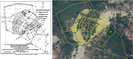
Fig. 1: Nargodu Village
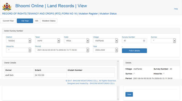
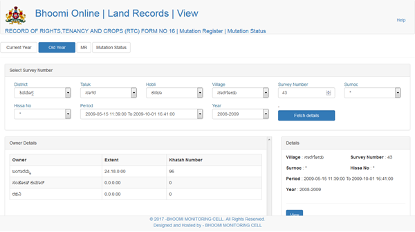
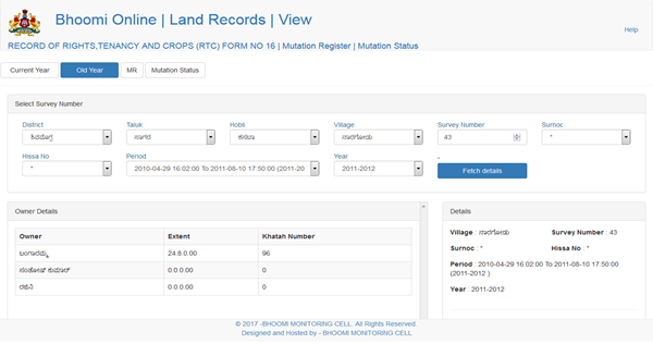
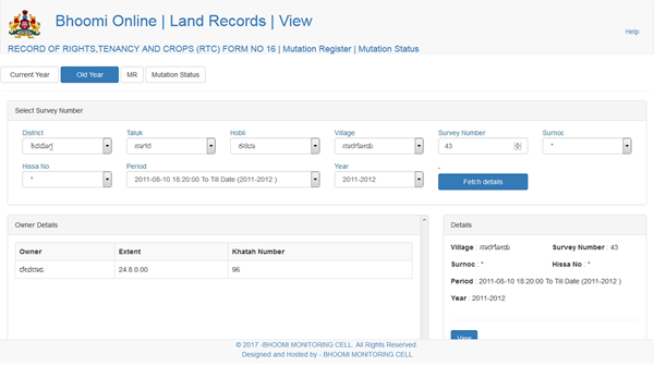
Land records accessed from Bhoomi web page indicates that Survey number 43 was Khata Kan unitll 2009, which was further in name of Bangaramma and Devaraju since 2012 till date (Figure 3, Table 1) due to irrational allotments by the senseless district administration and local politicians.
Table 1: Nargodu Land records
Slno |
Year |
Owner - Bhoomi Land Records |
Area (Ac.Gu) |
1 |
untill 2009 |
Khata Kan |
24.18 |
2 |
2011/12 – 2017 |
Bangaramma, Devaraju |
24.08 |
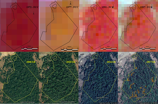
Fig. 2: Land use dynamics (24.08 acre forest lands)
 |
2000 - 2001 |
|
2001 – 2009 (15 May 2009) |
|
2009 (15 May to 1 October) |
|
2009 until 10 August 2011 |
|
10 August 2011 till date (2017) |
Fig. 3: Mutation Status – Bhoomi Land Records
(Source: https://landrecords.karnataka.gov.in , Accessed on 13 December 2017)
The current owner of the land claims that the land is being used for growing crops such as ginger, jowar etc. Record of Rights, Tenancy and Crops (R.T.C) doesn’t indicate any crop being grown in the region (Figure 4) and temporal remote sensing data (and field investigations) highlights the presence of good patch of native forests.
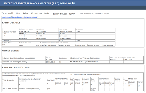
Fig. 4: Record of Rights, Tenancy and Crops (R.T.C) – Bhoomi Land Records
(Source: https://landrecords.karnataka.gov.in , Accessed on 13 December 2017)
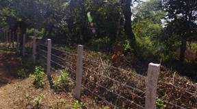
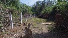
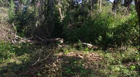
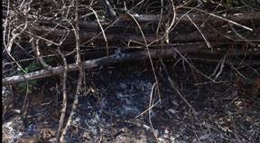
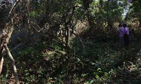
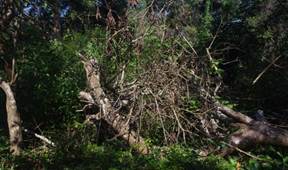
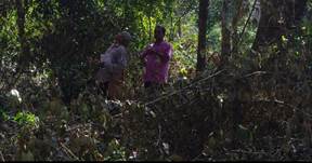
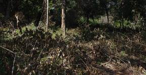
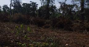
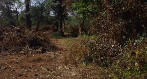
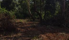
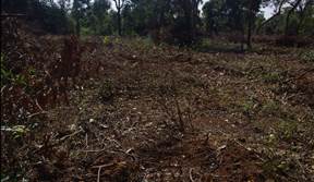
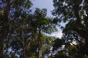
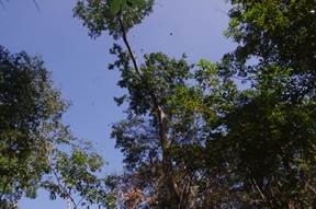
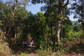
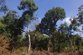
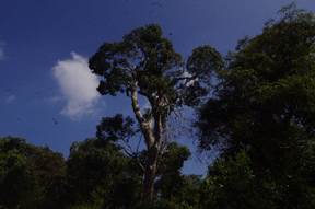
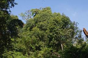
Field work carried out at Sagara on 28 November 2017 and GPS track is indicated in Figure 5. Field work photo graphs of field investigations are depicted in Figure 8. Field work shows that survey number 43 is a pristine forest having about 84 species of trees, 36 species of shrubs, 21 species of climbers (Table 2), conforming the presence of pristine forests, which is clandestinely alloted to an individual for private activities while depriving the community their right to use the forest for livelihood.
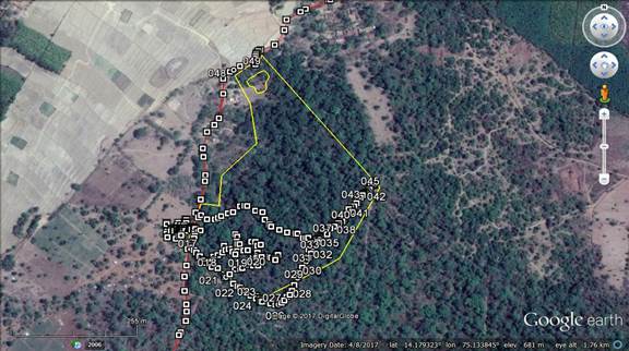
Fig. 5: Survey on 28 November 2017
 |
|
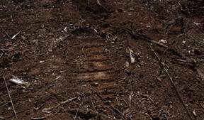
FENCE |
|
|
|
|
|
|
|
|
|
|
|
|
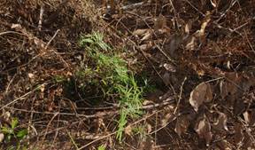
TREE FELLING |
|
|
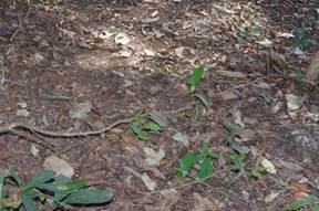
REGENERATION |
|
|
|
|
|
|
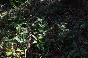
Glimpse of mature natural vegetation |
Fig. 6: Field work Photographs
|
Dr. T.V. Ramachandra
Centre for Sustainable Technologies, Centre for infrastructure, Sustainable Transportation and Urban Planning (CiSTUP), Energy & Wetlands Research Group, Centre for Ecological Sciences, Indian Institute of Science, Bangalore – 560 012, INDIA.
E-mail : tvr@ iisc.ac.in
Tel: 91-080-22933099/23600985,
Fax: 91-080-23601428/23600085
Web: http://ces.iisc.ac.in/energy
Vinay SEnergy & Wetlands Research Group, Centre for Ecological Sciences, Indian Institute of Science, Bangalore – 560 012, INDIA.
E-mail: svinay@iisc.ac.in
Vishnu D. MukriEnergy & Wetlands Research Group, Centre for Ecological Sciences, Indian Institute of Science, Bangalore – 560 012, INDIA.
E-mail: vishnudevumukri@gmail.com
Subash Chandran M.DEnergy & Wetlands Research Group, Centre for Ecological Sciences, Indian Institute of Science, Bangalore – 560 012, INDIA.
E-mail: subhashc@iisc.ac.in
Citation:Ramachandra T V, Vinay S, Vishnu D Mukri, M D Subash Chandran, 2017. Irrational Allotment Of Common Lands - Kan Sacred Forests In Sagar Taluk, Shimoga District, Karnataka For Non-Forestry Activities, Sahyadri Conservation Series 73, , ENVIS Technical Report 135, Environmental Information System, CES, Indian Institute of Science, Bangalore 560012.
| Contact Address : |
| |
Dr. T.V. Ramachandra
Energy & Wetlands Research Group,
Centre for Ecological Sciences, TE 15, New Biology Building, Third Floor, E Wing, [Near D Gate], Indian Institute of Science, Bangalore – 560 012, INDIA.
Tel : 91-80-22933099 / 22933503-extn 107
Fax : 91-80-23601428 / 23600085 / 23600683 [CES-TVR]
E-mail : tvr@ iisc.ac.in, energy.ces@iisc.ac.in ,
Web : http://wgbis.ces.iisc.ac.in/energy |
| |