| |
Sayhadri Conservation Series 73 |
ENVIS Technical Report: 135, December 2017 |
 |
IRRATIONAL ALLOTMENT OF COMMON LANDS - KAN SACRED FORESTS IN SAGAR TALUK, SHIMOGA DISTRICT, KARNATAKA FOR NON-FORESTRY ACTIVITIES
 |
|
| T.V. Ramachandra Vinay S
Vishnu D. Mukri M.D.Subash Chandran |
Energy & Wetlands Research Group, Centre for Ecological Sciences,
Indian Institute of Science, Bangalore, Karnataka, 560 012, India.
E Mail: tvr@ iisc.ac.in,
Tel: 91-080-22933099, 2293 3503 extn 101, 107, 113
|
|
Sacred Groves (Kans) of Sagara - ಸಾಗರದ ದೇವರ ಕಾಡುಗಳು
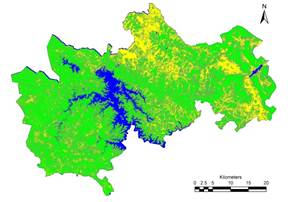
Sagara taluk (Figure 1) is located in the Shivamogga district of Karnataka state. Extending from 13.8549O N to 14.3427O N and 74.6259O E to 75.2955O E, Sagara taluk has an area of 1933 sq.km. Sagara taluk has numerous lakes and tanks (over 450) and streams which join either River Varada (Tungabhadra) or River Sharavathi (Figure 2).
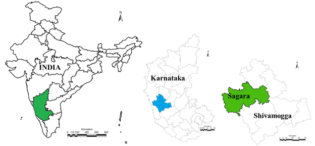
Figure 1: Study area
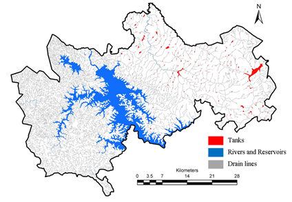
Figure 2: Drainage network in sagara taluk
Rainfall (Figure 3) in Sagara taluk varies from as low as 2000 mm towards the plains to as high as over 4500 mm at the Ghats. Monthly rainfall variation in Sagara is as depicted in figure 4, indicating rainfall is due to the south west monsoons and over 85% occurring between June to September.
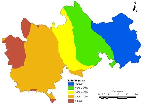
Figure 3: Annual Rainfall (1901 – 2010 average) in mm
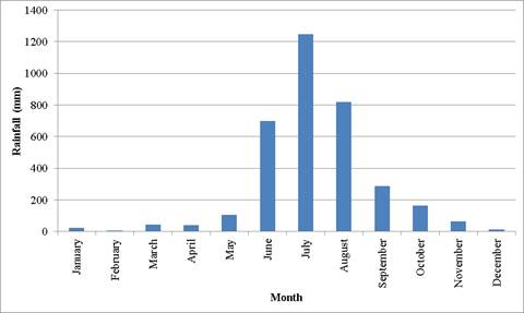
Figure 4: Monthly Rainfall distribution
Temperature (Figure 5) varies from as low as 15 Degree Celsius during the months of December and January to as high as 32 degree Celsius in the months of March, April and May. Potential evapotranspiration (Figure 5) is high in the peak summers i.e., over 5 mm per day, and reduces to 3 mm per day during monsoon which is catered by the intercepted rainfall waters, and is almost constant during winter nearly 3.8 to 4 mm per day.
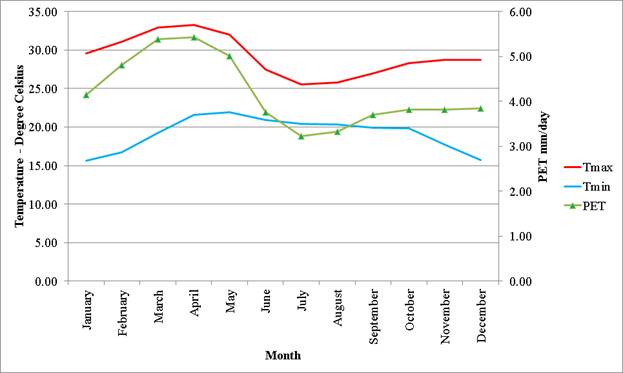
Figure 5: Temperature and PET dynamics in Sagara
Demographically, Sagara has a population of 206112 persons (2011 census) which has grown at a decadal rate of 2.55% since 2001.
Land use Analysis: Land use Land cover (LULC) dynamics is a major concern, as the abrupt changes has a negative impact on ecology, climate, hydrological regime, ecological flow, and also people’s livelihood in the region. LULC dynamics are specific to a region and vary from region to region. Land Cover refers to the observed physical cover on the earth’s surface. Land cover essentially distinguishes the region under vegetation with that of non-vegetation. Land use refers to use of the land surface through modifications by humans and natural phenomena. Land use can be classified into various classes such as water bodies, built up, forests, agriculture, open lands, sand, soil, etc. Land use modifications alter the structure of the landscape and hence the functional ability of the landscape. The modification includes conversion of forest lands, scrublands to agricultural fields, and cultivation lands to built-up, construction of storage structures for water bodies leading to submergence of land features that may vary from small scale to large scale.
Landscape is heterogeneous land area of interacting systems which forms an interconnected system called ecosystem. The functional aspects (interaction of spatial elements, cycling of water and nutrients, bio-geo-chemical cycles) of an ecosystem depends on its structure (size, shape, and configuration) and constituent’s spatial patterns (linear, regular, aggregated). The status of a Land use land cover can be visualized using the LULC information. Land use land cover information of a region provides a base for accounting the natural resources availability and its utilization. The information pertaining to LULC provides a framework for decision making towards sustainable natural resources management sensors.
Satellite remote sensing technology provide consistent measurements of landscape condition, allowing detection of both abrupt changes and slow trends over time for managing natural resources. Remote Sensing (RS) data with Geographic Information System (GIS) and Global Positioning System (GPS) helps in effective measure of landscape dynamics in cost effective manner.
Method involved in classification of a remotely sensed data using GIS is as depicted in Figure 6. Data Acquisition involves collection of the remotely sensed satellite data, ancillary data include cadastral revenue maps (1:6000), the Survey of India (SOI) topographic maps (1:50000 and 1:250000 scales), vegetation map of South India developed by French Institute (1986) of scale 1:250000. Topographic maps provided ground control points (GCP’s) to rectify remote sensing data and scanned paper maps. French institute maps were delineated to identify the forest cover and used to classify the RS data. Other ancillary data includes land cover maps, administration boundary data, transportation data (road network), etc. Pre-calibrated GPS (Global Positioning System - Garmin GPS units) were used for field data collection, which were used for RS data preprocessing, classification as well as for validation. Satellite data of 1973 to 2012 were used to understand the landscape dynamics in Sagara taluk.
Figure 6: Method - land use analysis
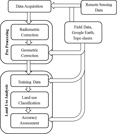
Pre-processing of data: The remote sensing data is checked for radiometric errors and geometric errors. The radiometric errors are rectified through radiometric correction, and the image is geometrically rectified by geo-referencing the image. Geo-registration of remote sensing data has been done using ground control points collected from the field using pre calibrated GPS and also from known points (such as road intersections, etc.) collected from geo-referenced topographic maps published by the Survey of India. The geo-referenced image is cropped to the study area. Vector data of the district, taluk, river basins and village boundaries, drainage network, water bodies (lakes, ponds) were digitized from the Survey of India topographic maps, cadastral maps and digital elevation models. Population census and taluk wise village boundaries were collected from the Directorate of Census Operations (http://censuskarnataka.gov.in).
Land use classification and accuracy assessment: The method involves i) generation of False Colour Composite (FCC) of remote sensing data (bands – green, red and NIR). This helped in locating heterogeneous patches in the landscape ii) selection of training polygons covering 15% of the study area and uniformly distributed over the entire study area, iii) loading these training polygons co-ordinates into pre-calibrated GPS, vi) collection of the corresponding attribute data (land use types) for these polygons from the field, iv) Supplementing this information with Google Earth/Bhuvan. Land use classification was done using supervised pattern classifier - Gaussian maximum likelihood algorithm based on various classification decisions using probability and cost functions Land uses during the different period were computed using the temporal remote sensing data through open source GIS: GRASS- Geographic Resource Analysis Support System (http://ces.iisc.ac.in/grass). The land use was classified into five major categories such as Built up, Water, Agriculture, Plantation, Forest. 60% of the derived signatures (training polygons) were used for classification and the rest for validation. Statistical assessment of classifier performance based on the performance of spectral classification considering reference pixels is done which include computation of kappa (κ) statistics.
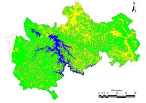
Land use dynamics of Sagara taluk is presented in table 1 and figure 7. Land use analysis shows that the forests have reduced from 57.3%in 1973 to 42.57% in 2013 due to intense agriculture and horticulture activities.
Table 1: Land use dynamics of Sagara (all units in %)
Year |
Urban |
Vegetation |
Water |
Others |
Plantations |
1973 |
0.08 |
57.29 |
4.90 |
26.98 |
10.76 |
1990 |
0.11 |
44.17 |
7.71 |
12.13 |
35.87 |
2001 |
0.13 |
46.03 |
6.35 |
10.73 |
36.77 |
2012 |
0.13 |
42.57 |
6.81 |
13.29 |
37.20 |
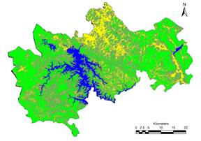
Status of Forest in Sagara indicating various land use categories as per the French institute maps (Pascal 1982) is depicted in Figure 8. In addition to the land use analysis using temporal medium resolution satellite imageries, Google earth was use to map kan boundaries according to the cadastral maps. These cadastral maps were rectified for geometric errors considering various prominent points on the ground as well as on the maps. The rectified maps were converted to Keyhole Markup Language files (KML files) and encroachments were delineated for Sagara kans (selected kans from Forest Working plan of Sagara division 2001-11). The results of encroachment areas are depicted in Table 2.
Figure 7: Land use dynamics in Sagara
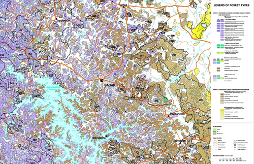
Figure 8: French Institute map of Sagara Taluk
Table 2: Status of Kan forest in Sagara division
Village Name |
Cadastral Survey number |
Cadastral Map Area in Ha |
Encroachment Area in Hectare |
2004 |
2014 |
Change between 2004 - 2014 |
Adhranthe |
62 |
4.74 |
0.67 |
0.71 |
0.04 |
Arehuda |
80 |
19.57 |
0.00 |
0.00 |
0.00 |
Avinalli |
101 |
48.45 |
1.36 |
2.91 |
1.55 |
Avinalli |
35 |
10.69 |
0.09 |
0.26 |
0.17 |
Bardavalli |
285, 286 |
56.82 |
5.60 |
6.72 |
1.12 |
Barur |
136 |
199.11 |
63.78 |
71.09 |
7.32 |
Bellanne |
44 |
12.23 |
0.00 |
0.00 |
0.00 |
Bellenne |
50 |
8.28 |
0.42 |
0.61 |
0.19 |
Belur |
122 |
42.87 |
0.00 |
0.00 |
0.00 |
Belur |
43 |
5.27 |
1.65 |
1.85 |
0.20 |
Belur |
93 |
79.52 |
24.44 |
26.34 |
1.90 |
Bhimneri |
17, 18 |
24.68 |
7.88 |
10.11 |
2.23 |
Chikkanallur |
159, 160 |
32.89 |
0.00 |
0.00 |
0.00 |
Chikkanallur |
168 |
61.87 |
9.86 |
10.70 |
0.84 |
Chikkanallur |
28, 37 |
174.83 |
54.47 |
73.54 |
19.06 |
Chikkanallur |
49, 50 |
49.32 |
18.28 |
24.47 |
6.18 |
Genasinkuni |
121 |
29.05 |
3.59 |
4.75 |
1.16 |
Gulehalli |
15 |
1.33 |
0.00 |
0.00 |
0.00 |
Gulehalli |
37 |
17.87 |
0.72 |
0.97 |
0.25 |
Haitur |
11 |
35.76 |
3.01 |
3.33 |
0.32 |
Heggattu |
24 |
12.85 |
0.73 |
2.22 |
1.49 |
Hirenallur |
231 |
22.93 |
0.00 |
0.00 |
0.00 |
Hirenallur |
242 |
13.64 |
0.00 |
0.00 |
0.00 |
Hirenallur |
249 |
8.24 |
0.00 |
0.00 |
0.00 |
Hirenallur |
284 |
46.50 |
0.00 |
0.00 |
0.00 |
Hosahalli |
35 |
12.77 |
5.06 |
5.06 |
0.00 |
Hosakoppa |
53 |
21.73 |
13.44 |
13.44 |
0.00 |
Hosakoppa |
68 |
11.79 |
0.00 |
0.00 |
0.00 |
Hunsur |
1 |
34.51 |
2.06 |
2.90 |
0.84 |
Lavigere |
104 |
7.96 |
0.47 |
0.82 |
0.35 |
Marsa |
17, 18 |
146.33 |
86.35 |
90.99 |
4.63 |
Marsa |
27 |
16.02 |
16.02 |
16.02 |
0.00 |
Marsa |
44, 46 |
19.66 |
19.66 |
19.66 |
0.00 |
Marthur |
120 |
29.46 |
3.03 |
3.03 |
0.00 |
Marthur |
90 |
7.28 |
7.28 |
7.28 |
0.00 |
Marur |
40 |
211.59 |
86.42 |
133.24 |
46.81 |
Marur |
73 |
18.16 |
6.91 |
9.87 |
2.96 |
Masur |
1 |
101.31 |
44.38 |
48.57 |
4.19 |
Masur |
102, 103, 145 |
67.36 |
14.78 |
15.66 |
0.88 |
Masur |
144, 129 |
58.96 |
11.77 |
12.25 |
0.48 |
Masur |
47 |
63.00 |
5.63 |
10.17 |
4.53 |
Mulkere |
17 |
15.60 |
0.89 |
2.04 |
1.14 |
Nadakalsi |
1 |
160.60 |
92.51 |
97.41 |
4.90 |
Nadakalsi |
111 |
9.97 |
0.00 |
0.00 |
0.00 |
Nadamanchale |
45 |
76.57 |
8.71 |
14.51 |
5.80 |
Sathlalu |
41, 42 |
119.20 |
9.38 |
12.40 |
3.02 |
Shiraguppe |
56 |
58.71 |
19.87 |
21.50 |
1.63 |
Shiravala |
95 |
3.14 |
0.00 |
0.00 |
0.00 |
Shiravala |
99 |
52.40 |
13.85 |
13.85 |
0.00 |
Suntikoppa |
133 |
41.50 |
41.50 |
41.50 |
0.00 |
Suntikoppa |
22 |
4.55 |
4.55 |
4.55 |
0.00 |
Suntikoppa |
234 |
83.19 |
12.16 |
19.57 |
7.41 |
Sydur |
221 |
28.53 |
6.74 |
15.60 |
8.86 |
Sydur |
272 |
13.27 |
3.23 |
6.46 |
3.23 |
Sydur |
352 |
86.43 |
11.93 |
12.29 |
0.36 |
Sydur |
358 |
21.70 |
0.96 |
1.99 |
1.03 |
Sydur |
388 |
23.62 |
3.60 |
7.96 |
4.36 |
Tadagalale |
155 |
16.42 |
16.42 |
16.42 |
0.00 |
Tadagalale |
300 |
146.70 |
29.98 |
29.98 |
0.00 |
Ullur |
29 |
23.26 |
9.11 |
9.59 |
0.49 |
Yalavarsi |
18 |
8.81 |
1.92 |
2.43 |
0.51 |
OBSERVATIONS
Presence of Lakes in the upstream of the well keeps the ground water table intact during all seasons with deviation of less than 0.6m (2ft) with respect to mean.
Presence of forests kept the lakes perennial. Kans with less variability and nonforests had higher variability in lake dynamics across months.
Forest plays major role in the maintaining hydrological status during post monsoons that can be observed by the Ground water (< 1.2 metre variation on an average), well maintained quantity of water in the lake and almost constant flow post monsoon.
Degradation of forest have led to deterioration of water sources, this could be observe in Lavigere lake when compared to Baruru lake (deviation is higher in Lavigere Lake compared to Baruru Lake).
Similarly comparing Kanle, Bilisiri, Varadamoola, Yennehole and Hulkodu shows presence of higher pristine forests in the area, higher quantity of water available in the post monsoons i.e., over 5 times.
During field visits (April 2014 to April 2016), large scale degradation of forest in Lavigere, Baruru, Huttadimba, Hosgunda, Masuru, and other due to anthropogenic activities (agriculture, timber, etc).
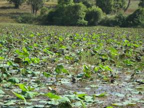
Of all the observed Lakes in Sagara, encroachments were found to be common followed by bad quality of water (where in DO is less than 2) due to complete macrophytes and other floral cover (see Common flora found in lakes of sagara), and siltation.
Some of the lakes in Sagara are well maintained by the village lake committees.
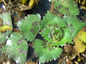
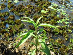
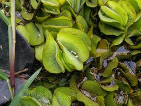
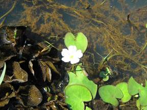
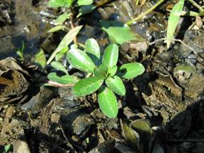
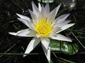
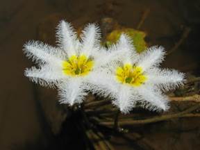
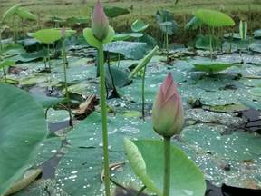
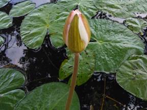
COMMON FLORA FOUND IN LAKES OF SAGARA
 |
|
Trapa |
Polygonum |
|
|
Salvinia |
Nymphaea |
. |
|
Ludvigia |
Nymphaea/Lily |
|
|
Nymphaea |
Nelumbos |
|
|
Nelumbos |
Nelumbos |
Birds in Sagara
Slno |
Family |
Species |
Common Name |
ಕನ್ನಡ |
1 |
Nectariniidae |
Nectarinin zeylonica |
Purple Sunbird |
ಕದಿರುಗಣಿ |
2 |
Picidae |
Dryocorpus javensis |
Great Black Woodpecker |
ಕಪ್ಪು ಮರಕುಟಿಗ |
3 |
Ardelidae |
Ardea cinerea |
Grey Heron |
ಕಬ್ಬಾರೆ ಹಕ್ಕಿ |
4 |
Oriolidae |
Oriolus xanthonuis |
Black Header Oriole |
ಕರೀತಲೆ ಹರಿಶಿನ ಬುರುಡೆ |
5 |
Meropidae |
Merops orientalis |
Small Green Beei-eater |
ಕಳ್ಳಿ ಪೀರ |
6 |
Dicruridae |
Dicrurus macrocercus |
Black Drongo |
ಕಾಜಾಣ |
7 |
Phasiandae |
Gallilnula sonneratti |
Grey Junglefowl |
ಕಾಡು ಕೋಳಿ |
8 |
Charadridae |
Vanellus indicus |
Red-wattled Lapwing |
ಕೆಂಪು ಟಿಟ್ಟಿಭ |
9 |
Coculidae |
Centropus bengalensis |
Lesser Coucal |
ಕೆಂಬೂತ |
10 |
Pycnonotidae |
Pycnonotus cafer |
Red Vented Bull Bulbul |
ಕೆಮ್ಮೀಸೆ ಪಿಕಳಾರ |
11 |
Ardelidae |
Ardeola grayii |
Pond Heron |
ಕೋಳದ ಬಕ |
12 |
Accipitridae |
Halisatur indicus |
Brahmini Kite |
ಗರುಡ |
13 |
Pisttacidae |
Psittacula krameri |
Rose Ringed Prakeet |
ಗಿಳಿ |
14 |
Sturnidae |
Acridotheres tristis |
Indian Myna |
ಗೊರವಂಕ |
15 |
Ardelidae |
Bubulcus ibis |
Cattle Egret |
ಗೋವಕ್ಕಿ |
16 |
Campephagidae |
Pericrocotus flammenus |
Scarlet Minivet |
ಚಿತ್ರಪಕ್ಷಿ |
17 |
Columbidae |
Streptopelia chinensis |
Spotted Dove |
ಚೋರೆ ಹಕ್ಕಿ |
18 |
Rallidae |
Gallilnula chloropus |
Indian Moorhen/ Common Moorhen |
ಜಂಬುಕೋಳಿ |
19 |
Ardelidae |
Casmerodius albus |
Large egret |
ಡೊಡ್ಡ ಬೆಳ್ಳಕ್ಕಿ |
20 |
Jacanidae |
Metopidius indicus |
Bronze-winged Jacana |
ದೇವಕ್ಕಿ |
21 |
Pittidae |
Pitta brachyara |
Indian Pitta |
ನವರಂಗ |
22 |
Phasiandae |
Pavo cristatus |
Common Peafowl/Indian Peafowl |
ನವಿಲು |
23 |
Rallidae |
Fulica atra |
Common Coot |
ನಾಮದಕೋಳಿ |
24 |
Phalacrocoracidae |
Phalacrocorax niger |
Little Cormorent |
ನೀರು ಕಾಗೆ |
25 |
Coraciidae |
Coracias bengalensis |
Indain Roller (Blue jay) |
ನೀಲಕಂಠ |
26 |
Rallidae |
Porphyrio porphyrio |
Purple Moorhen |
ನೀಲಿ ನಾಮದಕೋಳಿ |
27 |
Ciconiidae |
Anastomus oscitans |
Openbill Stork |
ಬಾಯ್ಕಳಕ |
28 |
Monarchinae |
Terpsiphone paradisi |
Asian Paradise-Flycatcher |
ಬಾಳದಂಡೆ ಹಕ್ಕಿ |
29 |
Threskiornithidae |
Thresiornis melanocephalus |
White Ibis |
ಬಿಳಿ ಕೆಂಬರಲು |
30 |
Corvidae |
Corvus splendens |
House Crow |
ಬೂದು ಕಾಗೆ |
31 |
Bucerotidae |
Ocyceros griseus |
Malabar Grey Hornbill |
ಬೂದು ಮಂಗಟ್ಟೆ ಪಕ್ಷಿ |
32 |
Ardelidae |
Egretta garzetta |
Little Egret |
ಬೆಳ್ಳಕ್ಕಿ |
33 |
Dicruridae |
Dicrurus pradiseus |
Racket Tailed Drongo |
ಭೀಮರಾಜ |
34 |
Corvidae |
Dendrocitta vagabunda |
Indian Tree Pie |
ಮಟಪಕ್ಷಿ |
35 |
Musicapidae |
Copsychus saularis |
Magpie Robin |
ಮಡಿವಾಳ |
36 |
Laridae |
Sterna aurantia |
River Tern |
ರೀವ ಹಕ್ಕಿ |
37 |
Accipitridae |
Milvus migrans |
Black Kite |
ಹದ್ದು |
38 |
Musicapidae |
Turdoides striatus |
Jungle Babbler |
ಹರಟೆಮಲ್ಲ |
39 |
Charadridae |
Vanellus malabaricus |
Yellow Wattled lapwing |
ಹಳದಿ ಟಿಟ್ಟಿಭ |
40 |
Rallidae |
Amaurornis phoenicurus |
White Breasted Water Hen |
ಹುಂಡುಕೋಳಿ |
41 |
Ciconiidae |
Leptoptilos javanicus |
Lesser Adjutant |
|
42 |
Anatidae |
Dendrocygna javanica |
Lesser Whistling Teal (Tree Duck) |
|
43 |
Rallidae |
Gallicrex cinerea |
Water Cock |
|
44 |
Columbidae |
Chalcophaps indica |
Emerald Dove |
|
45 |
Cuculidae |
Cuculus micropterus |
Indian Cuckoo |
|
46 |
Megalaimidae |
Megalaima malabarica |
Crimson Throated Barbet |
|
47 |
Picidae |
Dryocopus martius |
Great Black Woodpecker |
|
48 |
Pycnonotidae |
Pycnonotus leucotis |
White eared Bulbul |
|
49 |
Motacillidae |
Dendronanthus indicus |
Forest Wagtail |
|
50 |
Estrildidae |
Lonchura atricapilla |
Black Headed Munia |
|
51 |
Columbidae |
Treron phoenicoptera |
Common Green Pegion |
|
Flora of Sagara Kans and forests
Slno |
Family |
Species |
1 |
Alangiaceae |
Alangium salviifolium |
2 |
Anacardiaceae |
Holigarna arnottiana |
3 |
Anacardiaceae |
Holigarna ferruginea |
4 |
Anacardiaceae |
Holigarna grahamii |
5 |
Anacardiaceae |
Holigarna nigra |
6 |
Anacardiaceae |
Mangifera indica |
7 |
Anacardiaceae |
Nothopegia castaneaefolia |
8 |
Ancistrocladaceae |
Ancistrocladus heyneanus |
9 |
Annonaceae |
Artabotrys zeylanicus |
10 |
Annonaceae |
Demos lawii |
11 |
Annonaceae |
Goniothalamus cardiopetalus |
12 |
Annonaceae |
Orophea zeylanica |
13 |
Annonaceae |
Polyalthia fragrans |
14 |
Annonaceae |
Uvaria narum |
15 |
Apocynaceae |
Alstonia scholaris |
16 |
Apocynaceae |
Ervatamia heyneana |
17 |
Apocynaceae |
Hemidesmus indicus |
18 |
Apocynaceae |
Tabernaemontana alternifolia |
19 |
Arecaceae |
Calamus thwaitesii |
20 |
Arecaceae |
Caryota urens |
21 |
Asteraceae |
Eupatorium odoratum |
22 |
Bignoniaceae |
Pajanelia longifolia |
23 |
Bignoniaceae |
Stereospermum colais |
24 |
Burseraceae |
Canarium strictum |
25 |
Celastraceae |
Lophopetalum wightianum |
26 |
Clusiaceae |
Garcinia gummi-gutta |
27 |
Clusiaceae |
Garcinia indica |
28 |
Clusiaceae |
Garcinia morella |
29 |
Clusiaceae |
Mammea longifolia |
30 |
Clusiaceae |
Mesua ferrea |
31 |
Combretaceae |
Terminalia bellirica |
32 |
Combretaceae |
Terminalia paniculata |
33 |
Combretaceae |
Terminalia elliptica |
34 |
Cornaceae |
Mastixia arborea |
35 |
Datiscaceae |
Tetrameles nudiflora |
36 |
Dichapetalaceae |
Dichapetalum gelonioides |
37 |
Dilleniaceae |
Dillenia pentagyna |
38 |
Dipterocarpaceae |
Hopea ponga |
39 |
Ebenaceae |
Diospyros buxifolia |
40 |
Ebenaceae |
Diospyros candolleana |
41 |
Ebenaceae |
Diospyros montana |
42 |
Ebenaceae |
Diospyros nigra |
43 |
Ebenaceae |
Diospyros oocarpa |
44 |
Ebenaceae |
Diospyros paniculata |
45 |
Ebenaceae |
Diospyros sp. |
46 |
Ebenaceae |
Diospyros sylvatica |
47 |
Elaeagnaceae |
Elaeagnus conferta |
48 |
Elaeocarpaceae |
Elaeocarpus serratus |
49 |
Euphorbiaceae |
Agostistachys indica |
50 |
Euphorbiaceae |
Antidesma menasu |
51 |
Euphorbiaceae |
Aporosa cardiosperma |
52 |
Euphorbiaceae |
Bischofia javanica |
53 |
Euphorbiaceae |
Blachia denudata |
54 |
Euphorbiaceae |
Bridelia retusa |
55 |
Euphorbiaceae |
Fahrenheitia zeylanica |
56 |
Euphorbiaceae |
Macaranga peltata |
57 |
Euphorbiaceae |
Mallotus philippensis |
58 |
Euphorbiaceae |
Margaritaria indica |
59 |
Euphorbiaceae |
Phyllanthus emblica |
60 |
Flacourtiaceae |
Casearia championii |
61 |
Flacourtiaceae |
Flacourtia montana |
62 |
Flacourtiaceae |
Homalium zeylanicum |
63 |
Flacourtiaceae |
Hydnocarpus pentandra |
64 |
Gnetaceae |
Gnetum edule |
65 |
Icacinaceae |
Nothapodytes nimmoniana |
66 |
Lauraceae |
Actinodaphne angustifolia |
67 |
Lauraceae |
Alseodaphne semecarpifolia |
68 |
Lauraceae |
Beilschmiedia roxburghiana |
69 |
Lauraceae |
Cinnamomum malabatrum |
70 |
Lauraceae |
Litsea floribunda |
71 |
Lauraceae |
Litsea laevigata |
72 |
Lauraceae |
Litsea sp. |
73 |
Lauraceae |
Persea macrantha |
74 |
Lecythidaceae |
Careya arborea |
75 |
Leeaceae |
Leea indica |
76 |
Leguminosae |
Acacia auriculiformis |
77 |
Leguminosae |
Albizia lebbeck |
78 |
Leguminosae |
Archidendron monadelphum |
79 |
Leguminosae |
Butea monosperma |
80 |
Leguminosae |
Dalbergia horrida |
81 |
Leguminosae |
Derris sp. |
82 |
Leguminosae |
Entada rheedi |
83 |
Leguminosae |
Erythrina variegata |
84 |
Leguminosae |
Pithecellobium monadelphum |
85 |
Leguminosae |
Pterocarpus marsupium |
86 |
Leguminosae |
Saraca asoca |
87 |
Lythraceae |
Lagerstroemia microcarpa |
88 |
Lythraceae |
Lagerstroemia microcarpa |
89 |
Melastomataceae |
Memecylon talbotianum |
90 |
Melastomataceae |
Memecylon mabaricum |
91 |
Melastomataceae |
Memecylon terminale |
92 |
Meliaceae |
Aglaia elaeagnoidea |
93 |
Meliaceae |
Chukrasia tabularis |
94 |
Meliaceae |
Dysoxylum malabaricum |
95 |
Meliaceae |
Dysoxylum binectariferum |
96 |
Meliaceae |
Reinwardtiodendron anamalaiense |
97 |
Meliaceae |
Toona hexendra |
98 |
Meliaceae |
Trichilia connaroides |
99 |
Moraceae |
Antiaris toxicaria |
100 |
Moraceae |
Artocarpus gomezianus |
101 |
Moraceae |
Artocarpus heterophyllus |
102 |
Moraceae |
Artocarpus hirsuta |
103 |
Moraceae |
Artocarpus hirsutus |
104 |
Moraceae |
Ficus callosa |
105 |
Moraceae |
Ficus nervosa |
106 |
Moraceae |
Ficus sp. |
107 |
Moraceae |
Streblus asper |
108 |
Myristicaceae |
Knema attenuata |
109 |
Myristicaceae |
Myristica malabarica |
110 |
Myrtaceae |
Syzygium caryophyllatum |
111 |
Myrtaceae |
Syzygium cumini |
112 |
Myrtaceae |
Syzygium travancoricum |
113 |
Myrtaceae |
Syzygium gardnerii |
114 |
Myrtaceae |
Syzygium laetum |
115 |
Myrtaceae |
Syzygium sp. |
116 |
Olacaceae |
Strombosia ceylanica |
117 |
Oleaceae |
Chionathus mala-elengi |
118 |
Oleaceae |
Jasminum malabaricum |
119 |
Oleaceae |
Jasminum sp. |
120 |
Oleaceae |
Linociera malabarica |
121 |
Oleaceae |
Olea dioica |
122 |
Pandanaceae |
Pandanus fascicularis |
123 |
Rhamnaceae |
Ziziphus rugosa |
124 |
Rhizophoraceae |
Carallia brachiata |
125 |
Rubiaceae |
Canthium dicoccum |
126 |
Rubiaceae |
Canthium rheedii |
127 |
Rubiaceae |
Catunaregam spinosa |
128 |
Rubiaceae |
Ixora brachiata |
129 |
Rubiaceae |
Ixora coccinea |
130 |
Rubiaceae |
Psychotria dalzellii |
131 |
Rubiaceae |
Psychotria flavida |
132 |
Rutaceae |
Atlantia racemosa |
133 |
Rutaceae |
Toddalia asiatica |
134 |
Rutaceae |
Vepris bilocularis |
135 |
Rutaceae |
Zanthoxylum rhetsa |
136 |
Santalaceae |
Santalum album |
137 |
Sapindaceae |
Allophylus cobbe |
138 |
Sapindaceae |
Dimocarpus longan |
139 |
Sapindaceae |
Harpullia arborea |
140 |
Sapindaceae |
Sapindus laurifolius |
141 |
Sapindaceae |
Schleichera oleosa |
142 |
Sapotaceae |
Chrysophyllum roxburghii |
143 |
Sapotaceae |
Mimusops elengi |
144 |
Sapotaceae |
Xantolis tomentosa |
145 |
Smilacaceae |
Smailx zeylanica |
146 |
Sterculiaceae |
Helicteres isora |
147 |
Sterculiaceae |
Pterospermum diversifolium |
148 |
Sterculiaceae |
Sterculia guttata |
149 |
Symplocaceae |
Symplocos racemosa |
150 |
Tiliaceae |
Grewia tiliifolia |
151 |
Ulmaceae |
Aphananthe cuspidata |
152 |
Ulmaceae |
Celtis cinnamomea |
153 |
Ulmaceae |
Celtis timorensis |
154 |
Ulmaceae |
Trema orientalis |
155 |
Verbenaceae |
Callicarpa tomentosa |
156 |
Verbenaceae |
Vitex altissima |
|
Dr. T.V. Ramachandra
Centre for Sustainable Technologies, Centre for infrastructure, Sustainable Transportation and Urban Planning (CiSTUP), Energy & Wetlands Research Group, Centre for Ecological Sciences, Indian Institute of Science, Bangalore – 560 012, INDIA.
E-mail : tvr@ iisc.ac.in
Tel: 91-080-22933099/23600985,
Fax: 91-080-23601428/23600085
Web: http://ces.iisc.ac.in/energy
Vinay SEnergy & Wetlands Research Group, Centre for Ecological Sciences, Indian Institute of Science, Bangalore – 560 012, INDIA.
E-mail: svinay@iisc.ac.in
Vishnu D. MukriEnergy & Wetlands Research Group, Centre for Ecological Sciences, Indian Institute of Science, Bangalore – 560 012, INDIA.
E-mail: vishnudevumukri@gmail.com
Subash Chandran M.DEnergy & Wetlands Research Group, Centre for Ecological Sciences, Indian Institute of Science, Bangalore – 560 012, INDIA.
E-mail: subhashc@iisc.ac.in
Citation:Ramachandra T V, Vinay S, Vishnu D Mukri, M D Subash Chandran, 2017. Irrational Allotment Of Common Lands - Kan Sacred Forests In Sagar Taluk, Shimoga District, Karnataka For Non-Forestry Activities, Sahyadri Conservation Series 73, , ENVIS Technical Report 135, Environmental Information System, CES, Indian Institute of Science, Bangalore 560012.
| Contact Address : |
| |
Dr. T.V. Ramachandra
Energy & Wetlands Research Group,
Centre for Ecological Sciences, TE 15, New Biology Building, Third Floor, E Wing, [Near D Gate], Indian Institute of Science, Bangalore – 560 012, INDIA.
Tel : 91-80-22933099 / 22933503-extn 107
Fax : 91-80-23601428 / 23600085 / 23600683 [CES-TVR]
E-mail : tvr@ iisc.ac.in, energy.ces@iisc.ac.in ,
Web : http://wgbis.ces.iisc.ac.in/energy |
| |