|
|
ENVIS Technical Report: 104, March 2016 |
 |
DEVARABISANAHALLI LAKE: PATH TOWARDS ECOLOGICAL RESTORATION
|
 |
Ramachandra T.V.
Vinay .S
Sincy .V
Asulabha .K.S
Sudarshan .P. Bhat
Bharath H. Aithal
Energy and Wetlands Research Group, Centre for Ecological Sciences, Indian Institute of Science, Bangalore – 560012, India.
*Corresponding author: cestvr@ces.iisc.ac.in
Citation: Ramachandra T V, Vinay S, Sincy V, Asulabha K S, Sudarshan Bhat and Bharath H.Aithal, 2016. Devarabisanahalli Lake: Path towards Ecological restoration, ENVIS Technical Report 104, Energy & Wetlands Research Group, CES, IISc, Bangalore, India
|
Problems |
- Untreated Sustained inflow of sewage
- Encroachment
- Loss of interconnectivity
- sedimentation [due to silt transport with land cover changes in the catchment]
- invasive macrophytes
|
Solutions |
- removal of accumulated sediments – due to siltation (with the large scale land cover changes in the catchment)
- mapping of lake boundary and removal of all encroachments
- Sludge (at inlets) has nutrient value (evident from C: 23.77% and N: 2.38%) – use value as manure for agriculture/floriculture/ horticulture
- only treated sewage to the lake
- every drop of generated sewage in the catchment shall be treated through stp (sewage treatment plant) integrated with the constructed wetlands and shallow algae ponds (similar to jakkur lake).
- restoration of wetlands (with terrestrial plants such as typha, cyperus, etc.)
- introduction of native species of fish (column, surface and benthic dwellers) in consultation with fish experts
- regular monitoring of lake water quality (with the surrounding groundwater sources) through network of schools and college students from the locality
- regular harvesting of macrophytes (wetlands and also floating macrophytes in the lake) and algae pond – through local NGO or community groups
- ban on introducing any exotic fish species in the lake
- Restrictions on solid waste disposal in the lake bed
- Installation of water fountains (with music) which would enhance aesthetic value of the lake. In addition it helps in aeration and maintaining oxygen levels
- Introducing ducks (which also aid as mechanical aerators)
|
benefits |
- groundwater recharge and availability of groundwater
- meeting surrounding residential colony water demand
- groundwater with no contamination (as wetlands do the remediation by uptake of nutrients and heavy metals)
- maintaining green cover (with native trees and shrubs) in the lake catchment to enhance water percolation capability
|
1.1 Wetlands: Essential for bangaloreans’ survival
Wetlands (and lakes) constitute the most productive ecosystems with a wide array of goods and services. These ecosystems serve as life support systems; serve as habitat for a variety of organisms including migratory birds for food and shelter. They aid in bioremediation and hence aptly known as ‘kidneys of the landscape’. Major services include flood control, wastewater treatment, arresting sediment load, drinking water, protein production, and more importantly recharging of aquifers apart from aiding as sinks and climate stabilizers. The wetlands provide a low cost way to treat the community’s wastewater, while simultaneously functioning as wild fauna sanctuary, with public access. These ecosystems are valuable for education and scientific endeavors due to rich biodiversity.
Bangalore city (Karnataka State, India) has been experiencing unprecedented urbanisation and sprawl due to concentrated developmental activities in recent times with impetus on industrialisation for the economic development of the region. This concentrated growth has resulted in the increase in population and consequent pressure on infrastructure, natural resources and ultimately giving rise to a plethora of serious challenges such as climate change, enhanced green-house gases emissions, lack of appropriate infrastructure, traffic congestion, and lack of basic amenities (electricity, water, and sanitation) in many localities, etc. Temporal data analysis reveals that that there has been a growth of 925% in urban areas of Bangalore across four decades (1973 to 2013). Sharp decline in natural resources – 78% decline in trees and 79% decline in water bodies highlight unplanned urbanisation process in the city. Urban heat island phenomenon is evident from large number of localities with higher local temperatures. The city once enjoyed salubrious climate (about 14-16 °C during peak summer – May month in early 18th century), now has been experiencing higher temperatures (34 to 37° C) with altered micro climate and frequent flooding during rainy days. The study reveals the pattern of growth in Bangalore and its implication on local climate (an increase of ~2 to 2.5 ºC during the last decade) and also on the natural resources, necessitating appropriate strategies for the sustainable management of natural resources (water bodies, tree cover, etc.). The frequent flooding (since 2000, even during normal rainfall) in Bangalore is a consequence of the increase in impervious area with the high-density urban development in the catchment and loss of wetlands and vegetation.
Urban ecosystems are the consequence of the intrinsic nature of humans as social beings to live together (Ramachandra et al., 2012; Ramachandra and Kumar, 2008). The process of urbanisation contributed by infrastructure initiatives, consequent population growth and migration results in the growth of villages into towns, towns into cities and cities into metros. Urbanisation and urban sprawl have posed serious challenges to the decision makers in the city planning and management process involving plethora of issues like infrastructure development, traffic congestion, and basic amenities (electricity, water, and sanitation), etc. (Kulkarni and Ramachandra, 2006). Apart from this, major implications of urbanisation are:
- Loss of wetlands and green spaces: Urbanisation (925% concretisation or paved surface increase) has telling influences on the natural resources such as decline in green spaces (78% decline in vegetation) including wetlands (79% decline) and / or depleting groundwater table. Quantification of number of trees in the region using remote sensing data with field census reveal 1.5 million trees and human population is 9.5 million, indicating one tree for seven persons in the city. This is insufficient even to sequester respiratory carbon (due to breathing which ranges from 540 -900 g per person per day).
- Floods: Conversion of wetlands to residential and commercial layouts has compounded the problem by removing the interconnectivities in an undulating terrain. Encroachment of natural drains, alteration of topography involving the construction of high-rise buildings, removal of vegetative cover, reclamation of wetlands are the prime reasons for frequent flooding even during normal rainfall post 2000.
- Decline in groundwater table: Studies reveal the removal of wetlands has led to the decline in water table. Water table has declined to 300 m from 28 m over a period of 20 years after the reclamation of lake with its catchment for commercial activities. In addition, groundwater table in intensely urbanized area such as Whitefield, etc. has now dropped to 400 to 500m.
- Heat island: Surface and atmospheric temperatures are increased by anthropogenic heat discharge due to energy consumption, increased land surface coverage by artificial materials having high heat capacities and conductivities, and the associated decreases in vegetation and water pervious surfaces, which reduce surface temperature through evapotranspiration.
- Increased carbon footprint: Due to the adoption of inappropriate building architecture, the consumption of electricity has increased in certain corporation wards drastically. The building design conducive to tropical climate would have reduced the dependence on electricity. Adoption of building architecture unsuitable for Bangalore climate has contributed to higher electricity consumption and hence higher GHG (Greenhouse gases). Per capita electricity consumption in the zones dominated by high rise building with glass facades require 14000-17000 units (kWh) per year compared to the zones with eco-friendly buildings (1300-1500 units/person/year)Higher energy consumption, enhanced pollution levels due to the increase of private vehicles, traffic bottlenecks have contributed to carbon emissions significantly. Apart from these, mismanagement of solid and liquid wastes has aggravated the situation.
Unplanned urbanisation has drastically altered the drainage characteristics of natural catchments, or drainage areas, by increasing the volume and rate of surface runoff. Drainage systems are unable to cope with the increased volume of water, and are often blocked due to indiscriminate disposal of solid wastes. Encroachment of wetlands, floodplains, etc. obstructs flood-ways causing loss of natural flood storage.
1.2 WETLANDS - VITAL FOR BANGALOREANS
Wetlands are the kidneys of landscape and are vital for human survival. Wetlands are most productive environments; cradles of biological diversity that provide the water and productivity upon which countless species of plants and animals depend for survival; help in remediation - bioremediation. The wetlands perform various ecological functions such as:
- Wetlands act as kidneys of the landscape – aids in water purification (by uptake of nutrients and heavy metals).
- Provide wide range of ecosystem services such as food, fiber and waste assimilation.
- Support large biological diversity.
- Maintain stream flow, mitigate floods, and control erosion.
- Recharge ground water.
- Regulate microclimate.
- Mitigate floods and loss to human life s and properties
- Enhance the aesthetics of the landscape and support many significant recreational, social, and cultural activities, aside from being a part of our cultural heritage
Wetlands are indispensable for the countless benefits or “ecosystem services” that they provide humanity, ranging from freshwater supply, food and building materials, and biodiversity, to flood control, groundwater recharge, and climate change mitigation (http://www.ramsar.org/about/the-importance-of-wetlands).
1.3 NORMS VIOLATIONS: PERSISTENT ABUSE AND MISUSE
Bangalore Wetlands have been facing persistent threats due to (i) encroachments and unauthorised construction in the lake bed, wetlands, (ii) violation of prohibited activities in the valley zone / sensitive zone and senseless development activities (contrary to the norms of CDP: Comprehensive Development Plan/ RMP: Revised Master Plan, 2015), (iii) violation of regulated activities in the buffer zone (30 m as per BDA), (iv) dumping of municipal solid wastes, demolished building debris, excavated earth, etc., (v) sustained inflow of partially treated or untreated sewage (by BWSSB and high-rise buildings in the lake bed), (vi) disposal of industrial effluents into the drains connecting the lake, (vii) removal of interconnectivity among lakes – by encroachment of Rajakaluve and drains connecting lakes, (viii) dumping of untreated sewage through tankers, (ix) dumping of bio-medical waste, etc.
Major violations in Bangalore wetlands are:
- LAND USE CHANGES WITH THE CONSTRUCTION ACTIVITIES IN THE PRIMARY VALLEY – SENSITIVE REGIONS (as per RMP, 2015 of BDA: The Proposed SEZ in Agara-Bellandur region is located in the primary valley of the Koramangala Challaghatta valley. Primary valleys in Bangalore are sensitive regions as per sensitive zone notification - Circular/35/BBMP/2008, dated: 26/11/2008) and buffer zone for primary valley is 100 m.
- The region is a wetlands as per KARNATAKA LAKE CONSERVATION AND DEVELOPMENT AUTHORITY ACT, 2014 - KARNATAKA ACT NO. 10 OF 2015; KAR. ACT 12, pg 462; National Wetland Atlas, SAC Ahmedabad, 2009; Wetland rules, MoEF, Govt of India, 2010; RAMSAR Definition of wetlands.
- Removal of wetlands affects Intergeneration Equity.
- Depriving local residents of water: Wetlands helps in recharge of groundwater in the region.
- Encroachment of Rajakalve and streams (for example drain connecting Agara lake with Bellandur Lake).
- Deprives local residents of clean, air and water (as per Article 21 of the Constitution of India).
- Dumping of building debris and excavated earth in Wetlands and also in water-spread area of Bellandur Lake.
- Affects livelihood - Forceful eviction of local farmers due to acquisition of wetlands.
- Construction of compound wall depriving local fishermen of their fundamental right.
- Further encroachment of Bellandur Lake.
- Intimidation, threats and harassment of wetland researchers and conservationists.
1.4 WETLANDS – DEFINITIONS (CONVENIENTLY IGNORED BY BUREAUCRACY)
"Lake" means an inland water-body irrespective of whether it contains water or not, mentioned in revenue records as sarkari kere, kharab kere, kunte, katte or by any other name and includes the peripheral catchment areas, Rajakaluve main feeder, inlets, bunds, weirs, sluices, draft channels, outlets and the main channels of drainages to and fro; "Landscape" includes all forms of trees, shrubs, grasses whether naturally growing or planted in water bodies to enhance aesthetic value; [KARNATAKA LAKE CONSERVATION AND DEVELOPMENT AUTHORITY ACT, 2014, KARNATAKA ACT NO. 10 OF 2015].
STATEMENT OF OBJECTS AND REASONS Act 10 of 2015 - It is considered necessary,-
- to protect, conserve, reclaim, regenerate and restore lakes to facilitate recharge of depleting ground water by promoting integrated approach with the assistance of concerned Government departments, local and other authorities;
- to exercise regulatory control over all the lakes within the jurisdiction of all the Municipal Corporations and Bengaluru Development Authority including prevention and removal of encroachment of lake area and its natural drainage system.
- to prepare a plan for integrated development of lakes and to improve and also to create habitat of wetland for aquatic biodiversity, water birds and aquatic plants controlling pollution of lakes from sewage and other industrial effluents.
- to encourage participation of communities and voluntary agencies and to launch public awareness programmes for conservation, preservation and protection of lakes.
Wetlands defined as areas of land that are either temporarily or permanently covered by water exhibit enormous diversity according to their genesis, geographical location, water regime and chemistry – National Wetland Atlas, SAC Ahmedabad, 2009
Wetlands means an area or of marsh, fen, peatland or water, natural or artificial, permanent or temporary, with water that is static or flowing, fresh, brackish or salt, including areas of marine water, the depth of which at low tide does not exceed six meters and include all waters such as lakes, reservoirs, tanks, backwaters, lagoons, creeks, estuaries, and manmade wetland and the zone of direct influence on wetlands that is to say the drainage area or catchment region of wetlands as determined by the authority but does not include main river channels, paddy fields and the coastal wetland covered under the notification of the Government of India in the Ministry of Environment and Forest, S.O number 114 (E) dated the 19th February, 1991 published in the Gazette of India, Extraordinary, Part II, Section 3, Subsection (ii) od dated the 20th February 1991 - Wetland rules, MoEF, Govt of India, 2010
Wetland means land in which wetcrops can be grown by use of rain water or water obtained from any source which is not the property of state government – 1964: KAR. ACT 12, pg 462.
Ramsar Definition of a Wetland: Under the Convention on Wetlands (Ramsar, Iran, 1971) ‘wetlands’ are defined by Articles 1.1 and 2.1 as shown below:
Article 1.1: ‘For the purpose of this Convention wetlands are areas of marsh, fen, peatland or water, whether natural or artificial, permanent or temporary, with water that is static or flowing, fresh, brackish or salt, including areas of marine water the depth of which at low tide does not exceed six metres.
’
Article 2.1provides that wetlands: ‘may incorporate riparian and coastal zones adjacent to the wetlands, and islands or bodies of marine water deeper than six metres at low tide lying within the wetlands’.
Wetlands means an area or of marsh, fen, peatland or water, natural or artificial, permanent or temporary, with water that is static or flowing, fresh, brackish or salt, including areas of marine water, the depth of which at low tide does not exceed six meters and include all waters such as lakes, reservoirs, tanks, backwaters, lagoons, creeks, estuaries, and manmade wetland and the zone of direct influence on wetlands that is to say the drainage area or catchment region of wetlands as determined by the authority but does not include main river channels, paddy fields and the coastal wetland covered under the notification of the Government of India in the Ministry of Environment and Forest, S.O number 114 (E) dated the 19th February, 1991 published in the Gazette of India, Extraordinary, Part II, Section 3, Subsection (ii) od dated the 20th February 1991 - Wetland rules, MoEF, Govt of India, 2010
Wetland means land in which wetcrops can be grown by use of rain water or water obtained from any source which is not the property of state government – 1964: KAR. ACT 12, pg 462.
Wetlands defined as areas of land that are either temporarily or permanently covered by water exhibit enormous diversity according to their genesis, geographical location, water regime and chemistry – National Wetland Atlas, SAC Ahmedabad, 2009
"Lake" means an inland water-body irrespective of whether it contains water or not, mentioned in revenue records as sarkari kere, kharab kere, kunte, katte or by any other name and includes the peripheral catchment areas, Rajakaluve main feeder, inlets, bunds, weirs, sluices, draft channels, outlets and the main channels of drainages to and fro; "Landscape" includes all forms of trees, shrubs, grasses whether naturally growing or planted in water bodies to enhance aesthetic value; [KARNATAKA LAKE CONSERVATION AND DEVELOPMENT AUTHORITY ACT, 2014, KARNATAKA ACT NO. 10 OF 2015].
Ramsar Wetland Classification: The wetland types listed below are from the ‘Ramsar Classification System for Wetland Type as approved by Recommendation 4.7 and amended by Resolution VI.5 of the Conference of the Contracting Parties. The categories listed herein are intended to provide only a very broad framework to aid rapid identification of the main wetland habitats represented at each site’ (http://www.fao.org/docrep/003/x6611e/x6611e03d.htm; http://www.lrm.nt.gov.au/__data/assets/pdf_file/0013/10462/appendix7.pdf).
Human-made wetlands
- -- Aquaculture (e.g. fish/shrimp) ponds
- -- Ponds; includes farm ponds, stock ponds, small tanks; (generally below 8 ha).
- -- Irrigated land; includes irrigation channels and rice fields.
- -- Seasonally flooded agricultural land (including intensively managed or grazed wet meadow or pasture).
- -- Salt exploitation sites; salt pans, salines, etc.
- -- Water storage areas; reservoirs/barrages/dams/impoundments (generally over 8 ha).
- -- Excavations; gravel/brick/clay pits; borrow pits, mining pools.
- -- Wastewater treatment areas; sewage farms, settling ponds, oxidation basins, etc.
- -- Canals and drainage channels, ditches.
Inland Wetlands
L -- Permanent inland deltas.
M -- Permanent rivers/streams/creeks; includes waterfalls.
N -- Seasonal/intermittent/irregular rivers/streams/creeks.
O -- Permanent freshwater lakes (over 8 ha); includes large oxbow lakes.
P -- Seasonal/intermittent freshwater lakes (over 8 ha); includes floodplain lakes.
Q -- Permanent saline/brackish/alkaline lakes.
R -- Seasonal/intermittent saline/brackish/alkaline lakes and flats.
Sp -- Permanent saline/brackish/alkaline marshes/pools.
Ss -- Seasonal/intermittent saline/brackish/alkaline marshes/pools.
Tp -- Permanent freshwater marshes/pools; ponds (below 8 ha), marshes and swamps on inorganic soils; with emergent vegetation water-logged for at least most of the growing season.
Ts -- Seasonal/intermittent freshwater marshes/pools on inorganic soils; includes sloughs, potholes, seasonally flooded meadows, sedge marshes.
U -- Non-forested peatlands; includes shrub or open bogs, swamps, fens.
Va -- Alpine wetlands; includes alpine meadows, temporary waters from snowmelt.
Vt -- Tundra wetlands; includes tundra pools, temporary waters from snowmelt.
W -- Shrub-dominated wetlands; shrub swamps, shrub-dominated freshwater marshes, shrub carr, alder thicket on inorganic soils.
Xf -- Freshwater, tree-dominated wetlands; includes freshwater swamp forests, seasonally flooded forests, wooded swamps on inorganic soils.
Xp -- Forested peatlands; peatswamp forests.
Y -- Freshwater springs; oases.
Zg -- Geothermal wetlands
Zk(b) – Karst and other subterranean hydrological systems, inland
Note: ‘floodplain’ is a broad term used to refer to one or more wetland types, which may include examples from the R, Ss, Ts, W, Xf, Xp, or other wetland types. Some examples of floodplain wetlands are seasonally inundated grassland (including natural wet meadows), shrublands, woodlands and forests. Floodplain wetlands are not listed as a specific wetland type herein.
1.5 Threats: Loss of Wetlands - Encroachments
The rapid development of urban sprawl has many potentially detrimental effects including the loss of valuable agricultural and eco-sensitive (e.g. wetlands, forests) lands, enhanced energy consumption and greenhouse gas emissions from increasing private vehicle use (Ramachandra and Shwetmala, 2009). Vegetation has decreased by 32% (during 1973 to 1992), 38% (1992 to 2002) and 63% (2002 to 2010).
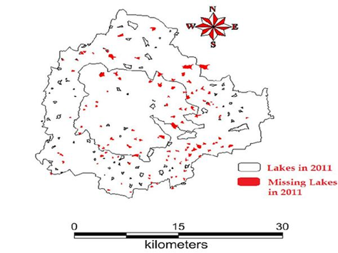
Figure 1: Lakes encroached by land mafia
Disappearance of water bodies or sharp decline in the number of water bodies in Bangalore is mainly due to intense urbanisation and urban sprawl. Latest field survey of 105 wetlands reveal that lakes (98%) have been encroached for illegal buildings (high raise apartment, commercial building, slums, etc.). Field survey of all lakes (in 2014-15) shows that nearly 90% of lakes are sewage fed, 38% surrounded by slums and 82% showed loss of catchment area. Also, lake catchments were used as dumping yards for either municipal solid waste or building debris. The surrounding of these lakes have illegal constructions of buildings and most of the times, slum dwellers occupy the adjoining areas. At many sites, water is used for washing and household activities and even fishing was observed at one of these sites. Multi-storied buildings have come up on some lake beds that have totally intervene the natural catchment flow leading to sharp decline and deteriorating quality of water bodies. This is correlated with the increase in built up area from the concentrated growth model focusing on Bangalore, adopted by the state machinery, affecting severely open spaces and in particular water bodies. Some of the lakes have been restored by the city corporation and the concerned authorities in recent times.
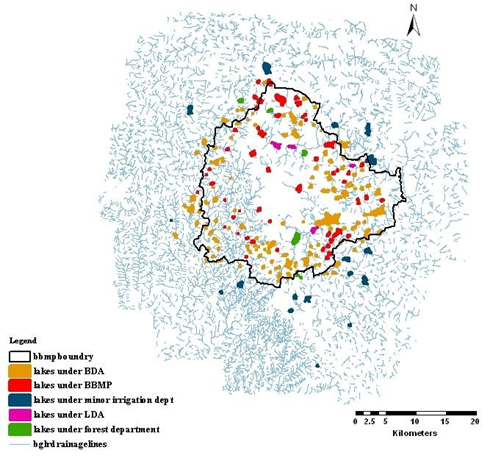
Figure 2: Spatial spread of lakes and custodians (too many – BBMP, BDA, LDA…. But too less effort to protect these lakes)
Threats faced by lakes and drainages of Bangalore:
-
Encroachment of lakebed, flood plains, and lake itself;
-
Encroachment of rajakaluves / storm water drains and loss of interconnectivity;
-
Lake reclamation for infrastructure activities;
-
Topography alterations in lake catchment;
-
Unauthorised dumping of municipal solid waste and building debris;
-
Sustained inflow of untreated or partially treated sewage and industrial effluents;
-
Removal of shoreline riparian vegetation;
-
Pollution due to enhanced vehicular traffic;
-
Too many para-state agencies and lack of co-ordination among them. Different custodians for upstream and downstream lakes in the valley (Figure 2).
The anthropogenic activities particularly, indiscriminate disposal of industrial effluents and sewage wastes, dumping of building debris have altered the physical, chemical as well as biological integrity of the ecosystem. This has resulted in the ecological degradation, which is evident from the current ecosystem valuation of wetlands. Global valuation of coastal wetland ecosystem shows a total of 14,785/ha US$ annual economic value. Valuation of relatively pristine wetland in Bangalore shows the value of Rs. 10,435/ha/day while the polluted wetland shows the value of Rs.20/ha/day (Ramachandra et al., 2005). In contrast to this, Varthur, a sewage fed wetland has a value of Rs.118.9/ha/day (Ramachandra et al., 2011). The pollutants and subsequent contamination of the wetland has telling effects such as disappearance of native species, dominance of invasive exotic species (such as African catfish, water hyacinth, etc.), in addition to profuse breeding of disease vectors and pathogens. Water quality analyses revealed of high phosphates (4.22-5.76 ppm) levels in addition to the enhanced BOD (119-140 ppm) and decreased DO (0-1.06 ppm). The amplified decline of ecosystem goods and services with degradation of water quality necessitates the implementation of sustainable management strategies to recover the lost wetland benefits.
1.6 CONSERVATION AND MANAGEMENT OF WETLANDS
In recent years, there has been concern over the continuous degradation of wetlands due to unplanned developmental activities (Ramachandra, 2002). Urban wetlands are seriously threatened by encroachment of drainage through landfilling, pollution (due to discharge of domestic and industrial effluents, solid wastes dumping), hydrological alterations (water withdrawal and inflow changes), and over-exploitation of their natural resources. This results in loss of biodiversity of the wetland and loss of goods and services provided by wetlands (Ramachandra, 2009). The mitigation of frequent floods and the associated loss of human life and properties entail the restoration of interconnectivity among wetlands, restoration of wetlands (removal of encroachments), conservation and sustainable management of wetlands (Ramachandra et al., 2012).
Despite good environmental legislations, loss of ecologically sensitive wetlands is due to the uncoordinated pattern of urban growth happening in Bangalore. Principal reason is lack of good governance and decentralized administration evident from lack of coordination among many Para-state agencies, which has led to unsustainable use of the land and other resources. Failure to deal with water as a finite resource is leading to the unnecessary destruction of lakes and marshes that provide us with water. This failure in turn is threatening all options for the survival and security of plants, animals, humans, etc. There is an urgent need for:
- Restoring and conserving the actual source of water - the water cycle and the natural ecosystems that support it - are the basis for sustainable water management
- Reducing the environmental degradation that is preventing us from reaching goals of good public health, food security, and better livelihoods world-wide
- Improving the human quality of life that can be achieved in ways while maintaining and enhancing environmental quality
- Reducing greenhouse gases to avoid the deleterious effects of climate change is an integral part of protecting freshwater resources and ecosystems.
- Maintaining intergeneration Equity
A comprehensive approach to water resource management is needed to address the myriad water quality problems that exist today from non-point and point sources as well as from catchment degradation. Watershed-based planning and resource management is a strategy for more effective protection and restoration of aquatic ecosystems and for protection of human health. The watershed approach emphasizes all aspects of water quality, including chemical water quality (e.g., toxins and conventional pollutants), physical water quality (e.g., temperature, flow, and circulation), habitat quality (e.g., stream channel morphology, substrate composition, riparian zone characteristics, catchment land cover), and biological health and biodiversity (e.g., species abundance, diversity, and range). The suggestions to implement in lakes in order to maintain its healthy ecosystem include:
- Good governance (too many para-state agencies and lack of co-ordination) - Single agency with the statutory and financial autonomy to be the custodian of natural resources (ownership, regular maintenance) and action against polluters (encroachers as well as those let untreated sewage and effluents, dumping of solid wastes).
- De-congest Bangalore: Growth in Bangalore has surpassed the threshold evident from stress on supportive capacity (insufficient water, clean air and water, electricity, traffic bottlenecks, etc.) and assimilative capacity (polluted water and sediments in water bodies, enhanced GHG – Greenhouse gases, etc.). No new projects shall be sanctioned and the emphasis would be on increasing green cover and restoration of lakes.
- Disband BDA – creation of Bangalore Development Agency has given impetus to inefficient governance evident from Bangalore, the garden city turning into ‘dead city’ during the functional life of BDA.
- Digitation of land records (especially common lands – lakes, open spaces, parks, etc.) and availability of this geo-referenced data with query option (Spatial Decision Support System) to public.
- Comprehensive development plan (CDP) for the city has to be developed through consultative process involving all stakeholders and should not be outsourced to outside agencies / consultants (from other countries).
- Removal of encroachment near to lakes after the survey based on reliable cadastral maps;
- Remove all encroachments (without any mercy) of wetlands, lakes, rajjakaluves (storm water drain) – encroachers have violated all humanitarian norms and deprived large section of the society of ecological services (provided by wetlands)
- Effective judicial system for speedy disposal of conflicts related to encroachment;
- Apply principles of ‘polluter pays’ principle to agencies responsible for contamination of Bangalore surface and ground water (Agency: BWSSB, industries);
- Action against regulatory agency (KSPCB) for dereliction of statutory duties and other responsibilities by allowing sustained contamination of water, land and air;
- Restriction of the entry of untreated sewage and industrial effluents into lakes;
- To make land grabbing cognizable non-bailable offence;
- Letting off only treated sewage into the lake through constructed wetlands and shallow algae ponds (as in Jakkur lake);
- Regular removal of macrophytes in the lakes;
- Implementation of ‘polluter pays’ principle as per water act 1974;
- Plant native species of macrophytes in open spaces of lake catchment area;
- Stop solid wastes (municipal and demolition debris) dumping into lakes; treatment and management of solid waste shall be as per MSW Rules 2000, GoI.
- Ensure proper fencing of lakes
- Restrictions on the diversion of lake for any other purposes - Lakes and wetlands provide ecological services (depending on the catchment integrity, duration may vary) – there are no dead lakes or wetlands
- Complete ban on construction activities in the valley zones;
- Monitoring of lakes through network of schools and colleges;
- Mandatory environment education at all levels (schools and colleges including professional courses).
Wetlands in Bangalore are to be restored considering:
Activities around lakes |
Norms to protect and conserve Wetlands |
Encroachment of lake bed and loss of interconnectivity among
lakes |
The Hon’ble Supreme Court in Civil appeal number 1132/2011 at SLP (C) 3109/2011 on January 28,2011 has expressed concern regarding encroachment of common property resources, more particularly lakes (and raja kaluves) and it has directed the state governments for removal of encroachments on all community lands.
Eviction of encroachment: Need to be evicted as per Karnataka Public Premises (eviction of unauthorised occupants) 1974 and the Karnataka Land Revenue Act, 1964 |
Buildings in the buffer zone of lakes |
In case of water bodies, a 30.0 m buffer of ‘no development zone’ is to be maintained around the lake (as per revenue records)
- As per BDA, RMP 2015 (Regional Master Plan, 2015)
- Section 17 of KTCP (Karnataka Town and Country Planning) Act, 1961 and sec 32 of BDA Act, 1976
- Wetlands (Conservation and Management) Rules 2010, Government of India; Wetlands Regulatory Framework, 2008.
- Valley zones are sensitive and are to be with any construction activities as per RMP 2015 of BDA
|
Valley Zones |
LAND USE CHANGES WITH THE CONSTRUCTION ACTIVITIES IN THE PRIMARY VALLIES – SENSITIVE REGIONS (as per RMP, 2015 of BDA). For example, the Proposed SEZ in Agara-Bellandur region is located in the primary valley of the Koramangala Challaghatta valley. Primary valleys in Bangalore are sensitive regions as per sensitive zone notification - Circular/35/BBMP/2008, dated: 26/11/2008) and buffer zone for primary valley is 100 m. |
Construction activities in the valley zone (SEZ by Karnataka Industrial Areas Development Board (KIADB)) in the valley zone |
This is contrary to sustainable development as the natural resources (lake, wetlands) get affected, eventually leading to the degradation/extinction of lakes. This reflects the ignorance of the administrative machinery on the importance of ecosystems and the need to protect valley zones considering ecological function and these regions are ‘NO DEVELOPMENT ZONES’ as per CDP 2005, 2015 |
Alterations in topography |
Flooding of regions would lead to loss of property and human life and, spread of diseases. |
Increase in deforestation in catchment area |
Removing vegetation in the catchment area increases soil erosion and which in turn increases siltation and decreases transpiration |
Documentation of biodiversity |
- The biodiversity of every water body should form part of the School, College, People’s Biodiversity Registers (SBR, CBR, PBR).
- The local Biodiversity Management Committees (BMC) should be given necessary financial support and scientific assistance in documentation of diversity.
- The presence of endemic, rare, endangered or threatened species and economically important ones should be highlighted
- A locally implementable conservation plan has to be prepared for such species
|
Implementation of sanitation facilities |
- The lakes are polluted with sewage, coliform bacteria and various other pathogens
- Preserving the purity of waters and safeguarding the biodiversity and productivity, dumping of waste has to be prohibited
- All the settlements alongside the water body should be provided with sanitation facilities so as not to impinge in anyway the pristine quality of water
|
Violation of regulatory and prohibitory activities as per Wetlands (Conservation and Management) Rules, 2010;
Regulatory wetland framework, 2008 |
Environment Impact Assessment (EIA) Notification, 2009.
Wetlands (Conservation and Management) rules 2010, Government of India; Regulatory wetland framework, 2008
Regulated activity
- Withdrawal of water/impoundment/diversion/interruption of sources
- Harvesting (including grazing) of living/non-living resources (may be permitted to the level that the basic nature and character of the biotic community is not adversely affected)
- Treated effluent discharges – industrial/ domestic/agro-chemical.
- Plying of motorized boats
- Dredging (need for dredging may be considered, on merit on case to case basis, only in cases of wetlands impacted by siltation)
- Constructions of permanent nature within 50 m of periphery except boat jetties
- Activity that interferes with the normal run-off and related ecological processes – up to 200 m
Prohibited activity
- Conversion of wetland to non-wetland use
- Reclamation of wetlands
- Solid waste dumping and discharge of untreated effluents
|
Damage of fencing, solid waste dumping and encroachment problems in Varthur lake series
|
High Court of Karnataka (WP No. 817/2008) had passed an order which include:
- Protecting lakes across Karnataka,
- Prohibits dumping of garbage and sewage in Lakes
- Lake area to be surveyed and fenced and declare a no development zone around lakes
- Encroachments to be removed
- Forest department to plant trees in consultation with experts in lake surroundings and in the watershed region
- Member Secretary of state legal services authority to monitor implementation of the above in coordination with Revenue and Forest Departments
- Also setting up district lake protection committees
- Implementation of Handling, Treatment and Management of Municipal Solid Waste as per MSW Rule 2000, GoI
|
Polluter Pays principle |
National Environment Policy, 2006
The principal objectives of NEP includes :
- Protection and conservation of critical ecological systems and resources, and invaluable natural and man-made heritage
- Ensuring judicious use of environmental resources to meet the needs and aspirations of the present and future generations
- It emphasizes the “Polluter Pays” principle, which states the polluter should, in principle, bear the cost of pollution, with due regard to the public interest
|
Prevention of pollution of lake |
National Water Policy, 2002
Water is a scarce and precious national resource and requires conservation and management.
Watershed management through extensive soil conservation, catchment-area treatment, preservation of forests and increasing the forest cover and the construction of check-dams should be promoted.
The water resources should be conserved by retention practices such as rain water harvesting and prevention of pollution. |
Discharge of untreated sewage into lakes |
The Environment (Protection) Act, 1986
- Lays down standards for the quality of environment in its various aspects
- Laying down standards for discharge of environmental pollutants from various sources and no persons shall discharge any pollutant in excess of such standards
- Restriction of areas in which industries, operations or processes shall not be carried out or carried out subject to certain safeguards
|
The water pollution, prevention and its control measures were not looked upon |
Water (Prevention and Control of Pollution) Act, 1974
- It is based on the “Polluter pays” principle.
The Pollution Control Boards performs the following functions :
- Advice the government on any matter concerning the prevention and control of water pollution.
- Encourage, conduct and participate in investigations and research relating to problems of water pollution and prevention, control or abatement of water pollution.
- Inspects sewage and effluents as well as the efficiency of the sewage treatment plants.
- Lay down or modifiy existing effluent standards for the sewage.
- Lay down standards of treatment of effluent and sewage to be discharged into any particular stream.
- Notify certain industries to stop, restrict or modify their procedures if the present procedure is deteriorating the water quality of streams.
|
Pathetic water scenario and insufficient drinking water in Bangalore |
The depletion of ground water and drying up off lakes has affected the water availability to meet the current population. At the 4% population growth rate of Bangalore over the past 50 years, the current population of Bangalore is 8.5 million (2011). Water supply from Hesaraghatta has dried, Thippagondanahalli is drying up, the only reliable water supply to Bangalore is from Cauvery with a gross of 1,410 million liters a day (MLD). There is no way of increasing the drawal from Cauvery as the allocation by the Cauvery Water Disputes Tribunal for the entire urban and rural population in Cauvery Basin in Karnataka is only 8.75 TMC ft (one thousand million cubic – TMC ft equals 78 MLD), Bangalore city is already drawing more water-1,400 MLD equals 18 TMC—than the allocation for the entire rural and urban population in Cauvery basin |
The restoration and conservation strategies has to be implemented for maintaining the ecological health of aquatic ecosystems, aquatic biodiversity in the region, inter-connectivity among lakes, preserve its physical integrity (shorelines, banks and bottom configurations) and water quality to support healthy riparian, aquatic and wetland ecosystems. The regular monitoring of waterbodies and public awareness will help in developing appropriate conservation and management strategies (Ramachandra, 2005).
Ecological and Environmental Implications:
-
Land use changes: Conversion of watershed area especially valley regions of the lake to paved surfaces would alter the hydrological regime.
-
Loss of Drainage Network:Removal of drain (Rajakaluve) and reducing the width of the drain would flood the surrounding residential as the interconnectivities among lakes are lost and there are no mechanisms for the excessive storm water to drain and thus the water stagnates flooding in the surroundings.
-
Alteration in landscape topography: This activity alters the integrity of the region affecting the lake catchment. This would also have serious implications on the storm water flow in the catchment.
-
The dumping of construction waste along the lakebed and lake has altered the natural topography thus rendering the storm water runoff to take a new course that might get into the existing residential areas. Such alteration of topography would not be geologically stable apart from causing soil erosion and lead to siltation in the lake.
-
Loss of Shoreline: The loss of shoreline along the lakebed results in the habitat destruction for most of the shoreline birds that wade in this region. Some of the shoreline wading birds like the Stilts, Sandpipers; etc will be devoid of their habitat forcing them to move out such disturbed habitats. It was also apparent from the field investigations that with the illogical land filling and dumping taking place in the Bellandur lakebed, the shoreline are gobbled up by these activities.
-
Loss of livelihood: Local people are dependent on the wetlands for fodder, fish etc. estimate shows that wetlands provide goods and services worth Rs 10500 per hectare per day (Ramachandra et al., 2005). Contamination of lake brings down goods and services value to Rs 20 per hectare per day.
Decision makers need to learn from the similar historical blunder of plundering ecosystems as in the case of Black Swan event (http://blackswanevents.org/?page_id=26) of evacuating half of the city in 10 years due to water scarcity, contaminated water, etc. or abandoning of Fatehpur Sikhri and fading out of AdilShahi’s Bijapur (inputs from V.Balasubramanian), or ecological disaster at Easter Island or Vijayanagara Empire.
It is the responsibility of Bangalore citizens (to ensure intergeneration equity, sustenance of natural resources and to prevent human-made disasters such as floods, etc.) to stall the irrational conversion of land in the name of development and restrict the decision makers taking the system (ecosystem including humans) for granted as in the case of wetlands by KIADB, BDA, BBMP and many such para-state agencies.
Status |
Wetlands: Abused, encroached and polluted |
Cause |
- Encroachment of lakebed, flood plains, etc.;
- Loss in lake interconnectivity - Encroachment of rajakaluves / storm water drains and loss of interconnectivity;
- Lake reclamation for infrastructure activities;
- Topography alterations in lake catchment;
- 38% is surrounded by slums and 82% showed loss of catchment area.
- unauthorised dumping of municipal solid waste and building debris;
- Pollution due to sustained inflow of Sewage (sustained inflow of untreated sewage) and industrial effluents.
- Sustained inflow of untreated or partially treated sewage and industrial effluents;
- Removal of shoreline riparian vegetation; and unabated construction activities in the valley zone has threatened these urban wetlands.
- Pollution due to enhanced vehicular traffic;
- Very poor governance - too many para-state agencies and lack of co-ordination among them.
|
Solution
|
- Good governance (too many para-state agencies and lack of co-ordination). Single agency with the statutory and financial autonomy to be the custodian of natural resources (ownership, regular maintenance and action against polluters (encroachers as well as those contaminate through untreated sewage and effluents, dumping of solid wastes). Effective judicial system for speedy disposal of conflicts related to encroachment;
- Digitation of land records (especially common lands – lakes, open spaces, parks, etc.) and availability of this geo-referenced data with query based information system to public.
- Removal of encroachment of lakes / wetlands, lake beds and storm water drains (connecting feeders) after the survey based on reliable cadastral maps;
- Decentralised treatment of sewage and solid waste (preferably at ward levels). Letting only treated sewage into the lake (as in Jakkur lake model); Ensure that sewage generated in a locality /ward is treated locally.
- Restriction of the entry of untreated sewage into lakes;
- To make land grabbing cognizable non-bail offence;
- Regular removal of macrophytes in the lakes;
- Implementation of ‘polluter pays’ principle as per water act 1974;
- Plant native species of macrophytes in open spaces of lake catchment area;
- Stop solid wastes dumping into lakes / in the lake bed
- Ensure proper fencing of lakes
- Restrictions on the diversion of lake for any other purposes;
- Complete ban on construction activities in the valley zones.
- Decentralised management of lakes through local lake committees involving all stakeholders
|
The restoration and conservation strategies has to be implemented for maintaining the ecological health of aquatic ecosystems, aquatic biodiversity in the region, inter-connectivity among lakes, preserve its physical integrity (shorelines, banks and bottom configurations) and water quality to support healthy riparian, aquatic and wetland ecosystems. The regular monitoring of water bodies and public awareness will help in developing appropriate conservation and management strategies. |
|
|