Study Area
Bhopal also known as the City of Lakes, is the capital of the Indian state of Madhya Pradesh and the administrative headquarters of Bhopal district and is the 17th largest city in India. Bhopal has an average elevation of 1400ft, with climate ranging from 27oC to 40oC. It has an annual rainfall of 1140 mm on an average. Annual growth of Madhya Pradesh is one of the highest in the country as Gross domestic state product is 11.68% in the 2014-2015. It is located in the central part of India and lies between the latitude 23°07' to 23°54' N, longitude 77°12' to 77°40' E (Fig. 1). Bhopal Municipal Corporation is the urban civic body which is responsible for development needs of the city and Bhopal urban development authority oversees the urban needs. The municipal corporation of Bhopal covers 285.88 km2 and is divided into 85 wards. Bhopal city population is 2.3 million as per the census 2011 (Census of India, 2011) and including 10km buffer, the population is 2.9 million. Figure 2 depicts the growth in population of Bhopal along with the population density (person per sq. km.).
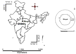
Fig. 1. Study area-Bhopal city with buffer
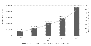
Fig.2. Growth in population of Bhopal city along with the population density (person per km2).
|