 |
Effectiveness of landscape Spatial Metrics with reference to the Spatial Resolutions of Remote Sensing Data |
 |
Bharath H. Aithal 1,2 Bharath Settur 1 Durgappa Sanna D.2 Ramachandra T V 1,2,3,*
1 Energy & Wetlands Research Group, Center for Ecological Sciences [CES],
2 Centre for Sustainable Technologies (astra),
3 Centre for infrastructure, Sustainable Transportation and Urban Planning [CiSTUP],
Indian Institute of Science, Bangalore, Karnataka, 560 012, India
*Corresponding author: cestvr@ces.iisc.ac.in
|
|
|
|
STUDY AREA
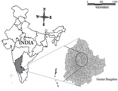
The influence of spatial resolution in assessing the landscape dynamics through spatial metrics has been done considering multi-resolution remote sensing data for the sample space - northern part of Greater Bangalore. Greater Bangalore is the capital city of the state of Karnataka, India and the hub of administrative, cultural, commercial, industrial, and knowledge activities. The spatial extent of Greater Bangalore is about 741 sq. km. and lies between the latitudes 12°39’00’’ to 13°13’00’’ N and longitude 77°22’00’’ to 77°52’00’’ E. It is the fifth largest metropolis in India currently with a population of about 8 million (Ramachandra and Kumar, 2008). The Sample space chosen for the study consists of representative fractions of all land use types.

Figure 1. Study Area: Greater Bangalore
|
|
|
Citation : Bharath H Aithal, Bharath Setturu, Sanna Durgappa D and Ramachandra T. V., (2012), Effectiveness of landscape Spatial Metrics with reference to the Spatial Resolutions of Remote Sensing Data, Proceedings of India Conference on Geo-spatial Technologies & Applications 2012, IIT Bombay, Mumbai, India, 12-14 April, 2012.
|


