| Previous Session | Paper 1 | Paper 2 | Paper 3 | Paper 4 | Next Session |
SESSION-11: Landuse and Urban Planning
PAPER-4: Reconnaissance of the East Coast of Tamilnadu
Ilangovan K, Debashish Pattnaik, Kavitha D., Sudeep P., Smitha Krishnan, Mary M.S.,
Anbazhagi S., Muthuandavan L., and Sharma C.B.S.R
CONTENTS-
Abstract
Introduction
Material and Methods
Observation
Discussion
Conservation and Development
Acknowledgement
Bibliography
| Abstract | up | previous | next | last |
Reconnaissance of the east coast of Tamilnadu was carried out covering nearly 750 Kms so as to gauge the role of wetlands in the coastal economy. The entire stretch was divided into 11 sectors and each sector into units of 10km. The survey was conducted along the villages on both sides of the road and a few towards the eastern and western parts. Peoples' perceptions were obtained through interviews and other data are recorded by direct field observations. Three surveys were made in all.
108 bridges, 737 culverts and 169km of storm drains were recorded. Nearly 570 water bodies were noted. The major wetlands include 11 rivers, 15 canals, 138 tanks, 17 lotus tanks, 70 backwater areas, 24 mangrove patches, 338 aquaculture ponds and 10 sites of social forestry. The status of water bodies was poor throughout the stretch. Out of 437, 140 villages were water scarce and had saline water intrusion. The potable water status was worse to critical at many places and the seriousness of scarcity was equal in all sectors. Diversion of run-off into the sea has left many wetlands dry throughout. These wetlands play a major role in potable water status; its role is also vital in maintaining the ecological balance of the other critical habitats along the coast and marine systems.
Besides the natural changes, the development along the east coast road has increased the pressure on the coastal systems. The wetlands that are already at critical stages will get eliminated if left unnoticed, which will increase the seriousness of the potable water scarcity. Documenting ecology of the entire coast is necessary for its conservation and development. A suitable blue print of action for the east coast on potable water, conservation and developmental awareness is likely to emerge from our preliminary work.
| A. Introduction | up | previous | next | last |
Coastal areas are commonly defined as the interface or transition areas between land and sea, they are diverse in function and form with no exact boundaries and are viewed as an integrated system . Coastal areas are also important ecologically, since they provide a number of environmental goods and services. The dynamic nature is a peculiar characteristic of the coast, which results from the transfer of matter, energy and living organisms between land and sea systems. It is estimated that 90 percent of the world's fish production is dependent on coastal areas at some time in their life cycle. In addition, these areas support large numbers of migratory and non-migratory waterfowl and shorebirds, and endangered reptiles (FAO 1998). So these areas are much important for the social and economic welfare of current and future generations since they support key economic and subsistence activities.
Wetlands generally occur at the interface between terrestrial ecosystems, such as uplands, grasslands and aquatic ecosystems. Thus, wetlands are neither wholly terrestrial nor wholly aquatic but exhibit characteristics of each. They also depend greatly on both. The wetland's function as a site of biodiversity is also valuable to humans, dependent on these ecosystems for commercial, hunting, and recreational uses. The capacity of wetlands to absorb a great amount of water also benefits developed areas. A wetland system can protect shorelines, cleanse polluted waters, prevent floods, and recharge groundwater aquifers, earning wetlands the nickname "the kidneys of the landscape" (FAO 1998). The functions of the wetland and the values of these functions to human society depend on a complex set of relationships between the wetland and the other ecosystems in the watershed. The watershed is a geographic area in which water, sediments and dissolved materials drain from higher elevations to a common low-lying outlet or basin, a point on a larger stream, lake, underlying aquifer or estuary (EPA 1998).
Physical features of coastal ecosystems, such as reefs and belts of mangrove are important for the mitigation of the effects of natural disasters, such as storm-tide surges, shoreline retreat or floods. These features also play an essential role in natural processes, such as land accretion, and help to control coastal erosion and other damage arising from wind and wave action (UNESCO, 1998, 2000).
The environment requires water of sufficient quality and quantity to maintain ecosystem function and biological resources, which in turn plays a major role in maintaining the quality and quantity of water resources (WBCSD, UNEP 1998). Water may be required for various purposes like drinking and personal hygiene, fisheries, agriculture, navigation, industrial production, power generation and recreational activities. Obviously, a wide variety of wetlands like marshes, swamps, bogs, peat land, open water bodies like lakes and rivers, mangroves, tidal marshes etc., which can be profitably used by man for his various needs and for environment development.
Coastline of Tamil Nadu extends over 1000 Km. The coastal tracts consist of upland plains, flood plains, deltaic plains and coastal plain. The geographical, biological, sociological and economic characters are exclusive on the coast. It contains critical terrestrial and aquatic habitats, which together comprise unique coastal ecosystem and support a rich biological diversity and contain valuable natural resources. These valuable and irreplaceable assets are subjected to ever increasing pressures. Further the Bay of Bengal is one of the favoured regions of low-pressure and is also subjected to the ongoing global change.
Since the coastal ecosystems are diverse and productive, sustaining them will require coordinated multi-disciplinary efforts involving all levels. In assessing effectiveness, productivity and value, particular emphasis is given to the identification of the on-the-ground outcomes and the status. Thus the coastal stretch of Tamil Nadu and its coastal systems were surveyed for it's on ground status of wetlands and potable water for its conservation and Development.
| B. Material and Methods | up | previous | next | last |
Tamilnadu is located in the southern end of Indian peninsula (8 5' - 13 35' N l atitude and 76 15' and 80 20' E longitude) with a geographical area of 130058 sq.Km. The length of TamilNadu coastal line extends to 1076 Km. 13 districts and 25 blocks lie in this coastal stretch. The coastal districts contain nearly 35 big and small urban centres and 591 (2001) fishing villages. The population in the coastal towns is nearly 27-30 % (1991) of the total population. The climate of the state has temperature range from maximum 42.6 to minimum of 8.4 ° C, which is also the same for the coastal regions. It has two rainy seasons from June to September and from October to November, but with opposite wind regime, corresponding to southwest and northeast monsoons, the latter contributing more. The annual average rainfall of Tamilnadu is 979.3cm. Rainfall varies along the coastal districts, the average annual rainfall is 110 cm for Kanchipuram, Villupuram, Cuddalore, Nagapattinam, and Thiruvarur, 75-110 cm for Thanjavur and Pudukottai, 75 cm and less for Ramanathapuran, Tuticorin and parts of Tirunveli and 100 cm for Kanyakumari.
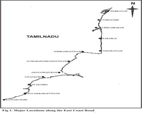
The study area extends from Muttukadu to Kanyakumari, but the divisions of sectors starts from Markanam to Kanyakumari covering 12 districts from Kanchipuram to Kaniyakumari, which also includes Pondicherry. The total distance covered is around 750kms(Table 1).
• Direct survey of the entire ECR
• Obtaining local peoples perceptions along the ECR
For implementing the above approaches, the east coast road is divided into 11 study sectors each about 60 Km from Markanam to Kanyakumari (Table 1), covering approximately 750 Km. Each sector is further divided into units of 10km. The unit has the Bay of Bengal as the eastern limit and the nearest village on the west. Three surveys were made in total
Physical Features and Peoples Perception
• Sketching and recording the physical features on both sides of the road. These constituted the ecology of the unit.
• Interviewing a local leader as per a Questionnaire on every aspect of the ECR. He / She is supposed to represent local people. These constitute people perceptions.
Checklist for monitoring
• Rivers, streams, bridges, culverts, tanks, ponds, drains, backwaters, mangrove, social forestry, seawater intrusion, fears and hopes about future and others.
Special stress on potable water
• Water scarcities, seasonal availability of water, depletion of underground water and intrusions of salinity into the aquifers were monitored from the coastal checkposts and villages, and information on the neighbouring villages were also collected.
Observations on the eleven sectors were made through three surveys, the results of the observation are summarised sector-wise (Table 2 and Table 3).
1 Sector A from Markanam to Cuddalore
30 Villages; 22 culverts; 8 bridges and 5 km of storm drains were recorded. 26 water bodies were noted of which tanks constitute 18; lotus tank 5; river 4 and 4 backwater areas. 7 aquaculture farms and 3 sites of social forestry were noted. Four varieties of potable water problems were recorded from 23 villages of which increasing scarcity 6; seasonal availability 9; depleting aquifer - 6 and saline water intrusion - 2. The Buckingham canal and Cheyyur saltpans north of Markkanam, the Yedianthittu estuary, Kaluveli wetland, Ariankuppam and Chunambar backwater areas are the ecologically fragile zones. During monsoon the west side of the ECR gets flooded and do not drain into the sea, leading to temporary water bodies.
2. Sector B from Cuddalore to Chidambaram
34 Villages; 61 culverts; 10 bridges and 17 km of storm drains were recorded. 34 water bodies were noted of which tanks 13; river 1; and 13 Aquaculture farms were noted. Four varieties of potable water problems were recorded from 24 villages of which increasing water scarcity constitute 10; seasonal availability - 7; depleting aquifer - 2 and saline water intrusion - 5. Perumaleri near Vadalor, Parangipattai Vellar estuary, Pichavaram mangroves areas are the ecologically fragile zones. Water shortage is found during summer and it floods in winter. Agriculture activities are much less due the presence of salt water.
3. Sector C from Chidambaram to Karaikal
27 Villages; 94 culverts; 12 bridges and 4 km of storm drains were recorded. 45 water bodies were noted of which tanks are 13; lotus tank 3; river 4; 2 backwater areas; canals 14 and 24 aquaculture farms were noted. Three types of potable water problems were recorded from 16 villages of which increasing scarcity - 8; seasonal availability 5 and saline water intrusion 3.
4. Sector D from Karaikal to Vedaranyam
25 villages; 74 culverts; 16 bridges and 13 km of storm drains were recorded. 75 water bodies were noted of which tanks are 17; river 5; 11backwater areas and 2 mangrove patches, 25 aquaculture farms and 3 sites of social forestry were noted. Four varieties of potable water problems were recorded from 21 villages of which increasing scarcity 2; seasonal availability 14; depleting aquifer 1 and saline water intrusion 4. Vedaranyam swamp is the ecologically fragile area.
5. Sector E from Vedaranyam to Adirampattinam
23 villages were recorded; 75 culverts and 10 bridges and 38 km of storm drains.. 98 water bodies were noted of which tanks 26; lotus tank 1; 7 backwater areas and 2 mangrove patches. 17 aquaculture farms and 2 sites of social forestry were noted. Four varieties of potable water problems were recorded from 17 villages of which increasing scarcity 2; seasonal availability 7; depleting aquifer 2 and saline water intrusion 5. Mangroves of Muthupet are the ecologically fragile area.
6. Sector F from Adirampattinam to S.P.Pattinam
36 villages; 116 culverts; 21 bridges and 10 km of storm drains were recorded. 140 water bodies were noted of which tanks 14; lotus tanks 3; river 1; 18 backwater areas and 5 mangrove patches. 183 aquaculture farms and a site of social forestry were noted. Three types of potable water problems were recorded from 22 villages of which increasing scarcity 1; seasonal availability 19 and depleting aquifer 2. Backwater areas and mangroves of Adirampattinam are the ecologically fragile areas.
7. Sector G from S.P.Pattinam to Ramnathapuram
25 villages recorded; 90 culverts; 9 bridges and 6 km of storm drains were recorded. 52 water bodies were recorded of which tanks 7; lotus tank 3; 18 backwater areas and 12 mangrove patches. 69 aquaculture farms were noted. Four types of potable water problems were recorded from 16 villages of which increasing scarcity 5; seasonal availability 8; depleting aquifer 1 and saline water intrusion 2. Backwater areas and mangroves of Tondi and Ramanathapuram are the ecologically fragile areas
8. Sector H from Ramnathapuram to Sayalkudi
17 Villages; 48 culverts; 6 bridges and 27km of storm drains were recorded. 48 water bodies were recorded of which tanks 16 and 5 backwater areas. Four types of potable water problems were noted from 17 villages of which increasing scarcity 10; seasonal availability 4; depleting aquifer 1 and saline water intrusion 2. Earvadi and Sayalkudi are the ecologically fragile areas.
9. Sector I from Sayalkudi to Tuticorin
23 villages; 53 culverts; 5 bridges, 19km of storm drains were recorded. 18 water bodies were noted of which 4 constitute backwater areas. Two varieties of potable water problems were recorded from 21 villages of which increasing scarcity were noted in 12, and saline water intrusion 9. Fresh water and saline water inlets of Vembar, Unstable soil and low habitation of Tuticorin are the ecologically fragile areas.
10. Sector J from Tuticorin to Kulasekarapattinam
16 Villages; 31 culverts; 7 bridges and 9km of storm drains were recorded. 14 water bodies were noted of which tanks 3; 2 lotus tanks and 2 backwater areas. Two types of potable water problems were noted from 20 villages of which increasing scarcity 17 and depleting aquifer 3.
11. Sector K from Kulasekarapattinam to Kanyakumari
41 villages; 74 culverts; 4 bridges were recorded. 13 water bodies were noted. Three varieties of potable water problems were recorded from 41 villages of which increasing scarcity 30, depleting aquifer 6 and saline water intrusion 5.
| D. Discussion | up | previous | next | last |
Coastline and beaches of Tamil Nadu in particular are dynamic and fast changing systems, which are vitally important to the local economy. The coasts and their varied users are confronted with many threats including coastal biodiversity loss, shore line erosion, wetland loss, un-sustained human access to coastal resources, development and pollution. Increasing damage to coastal areas of Tamilnadu will be linked more to the development than population increase or agriculture.
1. Water bodies
570 water bodies were recorded from the entire study area of which 155 are tanks; 71 backwater areas and 24 sites of mangroves, the status of most of the wetlands are in poor conditions. Many of these wetlands were drained and transformed by road construction, anthropogenic activities like unplanned urban and agricultural development, industrial siting after road development and resource extraction causing substantial economic and ecological losses. These water bodies play a vital role in storing the rainwater and recharging the ground water and the sub surface water (Table 3). Coastal wetlands such as lagoons and backwater help in reducing the effects of flooding by tides and also reduce saline water intrusion into the inland. Water, which wetlands hold is of greater value, recharging ground water.
Nearly 170kms of storm drains were present along the study area. These are valuable in retaining and detaining water for some time, which allows water to percolate to the water table. All wetlands perform certain function and have different values. Functions of each wetland differ with different degrees from place to place. Coastal wetlands of Tamil nadu are seasonal dependent on the cyclonic storms. Failure of monsoons in one or more years will have serious effect on the associated biota.
2. Potable waterThe seriousness of the water problems in all the sectors was equal. Almost all the sectors have saline water intrusion. 103 villages were found with increasing water scarcity (Table 2). In the entire region the surface water supplies are often limited by low rainfall, and coastal aquifers are a major water source. Groundwater extraction along the coastal stretch today exceeds the natural recharge rate, causing saltwater intrusion into the freshwater. The quantity and quality of water recharge to coastal aquifers are also affected by the drainage of irrigation water and by the construction of coastal roads and their drainage systems. The saltwater intrusion into coastal aquifers has long-term impacts not only for the sustainability, but also saltwater intrusion is difficult to handle and even more difficult to reverse.
Large portion of the coastal region of Tamilnadu is of alluvium formation and few regions are Cuddalore sand stone. The dynamics of alluvial landscape and natural sedimentation patterns which determine the nutrient and energy flows in coastal areas are increasingly being modified by human activities. This has higher impact on the vertical accretion by slowing down the accretion and thus aggravates salt-water intrusion and impairing drainage conditions in riverine, delta or estuarine areas. This further also reduces or blocks sediment supply to the coast.
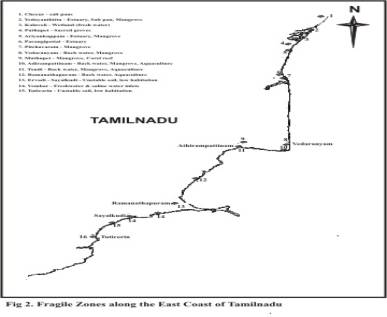
3. Fragile zonesThere are around 20 major fragile zones along the East coast (Figure 3), these are already undergoing stress of different degrees, and further stress on these zones will alter the ecology of the systems and regions. Habitat degradation is the major cause of biodiversity loss in wetlands about 26% and 44% of the area under mangrove along the coastline is estimated to have been lost. The coastal resource system is interdependent with inland resource systems, excessive cutting and clearing of vegetation on coastal areas will result in severe erosion. This enables to carry away the topsoil and cause heavy sedimentation of fish habitats, such as seagrass beds and coral reefs, degrading and ultimately destroying them.
Poor land use practices, agriculture activities and clearing of vegetation has increased land derived sediments flowing into the coral reef resulting in their degradation in Gulf of manner (Krishnamoorthy.R & Ramachandran.S. 2000)
Increasing demand for water are occurring for 3 key areas, human needs for safe drinking water and agriculture needs for expanding production to meet population growth and industrial needs to provide more goods and service for the growing population. There is an emerging fourth category that is the environmental needs, which must be met to attain sustainable development and maintaining the ecological balance. The need for water cannot be ignored which is crucial to protect the critical, fragile ecosystems of the coast. Less fresh water inundation was a reason for the degradation of mangroves and coral reef in Pichavaram, Muthupet and Gulf of Mannar.
4. Developmental activitiesThe East coast road development from Chennai to Kaniyakumari is likely to boost up the urban developments. The related impacts of nearly 35 coastal towns will be a poisoning threat to the coastal ecosystems, their biological diversity, environmental regulatory functions and role in generating employment and food. The population density along coastal region is higher compared to inland and will tend to increase with development in coming years, which will increase the pressure on the coastal resource.
Most of the developmental activities have direct impact on the coastal areas, the impact varies with the structure and type of development, and especially road construction along the coastal zone has various impacts. Road crossing are potential barriers to the movement of small stream fishes. Road crossing designs vary from simple, low water fords to massive concrete or earth filled structures, some of these crossing types may act as semi permeable or seasonal barriers for fish movement (Mattheus et.al 1994)
Road development will increase the potential for economic opportunities along the proposed ECR from Cuddalore to Kaniyakumari as happening from Chennai to Cuddalore. This will strongly attract immigration from economically depressed rural areas nearby. Larger numbers of younger generation are expected in the coastal areas, which will increase the demand of water, housing, energy, food, employment, goods and services. These will be a higher developmental challenge in future.
A total of 338 aquaculture sites were recorded throughout the study area of which, the sector-F from Adirampattinam to S.P.Pattinam alone had 183 sites. Sector G from S.P.Pattinam to Ramanathapuram had 67 (Table 3), concentration of aquaculture sites in these areas are likely to be damaging to the existing wetland ecosystem. Further reduction or restriction in the fresh water flow into these wetlands will leave many destroyed. Coastal Aquaculture must be environmentally managed and absorbed into the coastal management planning process.
Large portions of the coastal areas do not provide unique biological ecosysterns from sector H to J. The recreational and aesthetic values of these areas can be utilised for valuable tourism activities, as well as for industrial development and human settlements. Since the Tamilnadu coastal areas are expected to become more urbanised in future the dependence on coastal resource will become more stronger to meet the needs and to raise the economy. Rapid industrial development will emerge; the areas of less biological diversity can be utilized with better linking centers.
| E. Conservation and Development | up | previous | next | last |
Observations on the East Coast of Tamilnadu have brought out variety of issues that has to be put under immediate action. Lack of potable water and their cumulative impacts due to road construction, degradation of wetlands and other coastal systems are to be studied in detail. All the sectors are in similar stress. The areas from south of Karaikal needs an urgent and more detailed work on all the aspects of potable water. Conservation and development of wetlands have direct effect on the surface and ground water, thus development of wetlands will also improve the potable water needs.
A major enquiry into the water quality along the East Coast Road is urgent as great number of economic activities, with the exception of agriculture, are concentrated in the coastal towns of Tamilnadu. The road induced development will bring up more stress on this region, so the coastal systems have to be regularly monitored for its conservation and development.
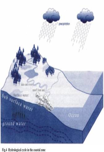
1. Potable water developmentThe survey has clearly shown the degrading status of the surface and ground water and a strategy for potable water development is highly necessary for the entire coastal stretch. Wetlands play a key role in the hydrological cycle by retaining run-off and slowing the flow of water. The retained water percolates into the underground aquifer and recharges ground water and also filters pollutants to both surface and ground water along the coast. Thus conservation of wetlands is vital to develop the potable water status along the East Coast.
The loss of wetlands will disturb the hydrological and hydro-ecological balance. If a wetland is lost or doesn't receive rainfall for few years the biological systems dependent will vanish disturbing the ecological balance of the region. A detailed study on the ecology of all the coastal wetlands and the related system is necessary for the development of the potable water and maintaining the ecological balance of the critical habitats.
2. Ground water rechargeThough the average rainfall ranges from 75-110 cm, which is highly dependent on the cyclone depression, the number of rainy days is coming down, the discharge of rainfall is concentrated with time in recent years. Fresh water inflow into the sea reduces the length of seawater intrusion into the ground water, still if the withdrawal of ground water is more it brings in seawater into the table, So it is highly necessary to conserve the part of runoff into sea.
Younger alluvial and deltaic deposits cover the coastal track of Tamilnadu. The deltaic deposits have high potential of ground water recharge. Artificial recharge programmes are necessary at regions with high potential of recharge to avoid the declining water table. The below said methods will be best suited for coastal regions like Tamilnadu
• Water spreading (spreading surplus water into large tanks and ponds)
• Injection method by injecting water into aquifer system (Adequate care on the water quality has to be taken)
• Construction of percolation ponds and check dams to allow percolation.
Areas of artificial recharge should be based on the intensity of the problems, the course of action should follow.
• Identifying the coastal aquifers and demarking the area for development and vulnerable areas needing immediate remedies
• Collection of hydrogeological, hydrological, land use, water use and ecological data
• Applying management technique and monitoring
Coastal zone management is the process of combining all the physical, biological and social aspects of the coastal zone within a single management framework holistic coastal management" to emphasise that careful planning and management of all sectoral activities simultaneously will result in greater overall benefits. Pursuing sectoral development plans independently of one another will result in diverse effects on each other. Since the entire sectors needed inputs in different aspects.
Both wetlands and potable water are interlinked. Since the coastal zones are fragile and diverse special attention is required for managing the resources, for which the resource base of the region has to be increased. The following guidelines can help for a better coastal zone management
• Increasing Resource base
• Land use planning land use zoning
• Restriction in resource use
• Multiple concept (Wetland, agro forestry)
• Monitoring resource bases and inter related systems
• Identifying constraints and development of management alternatives
• Policy evaluation and revision
| F. Acknowledgement | up | previous | next | last |
Citizen Consumer and Civic Action Group [CAG], Chennai funded the two surveys and Pondicherry University met the travel expenses of a survey. We thank the Government officials and Village heads for their cooperation and support.
| Bibliography | up | previous | next | last |
Anbazhagi. S , 2000. Ecography of East Coast Road - Thiruvanmyur to markanam, M.S. Dissertation Submitted to Pondicherry University.
Carl Gustaf Lundin and Olof Linden , Coastal Ecosystems: Attempts to Manage a Threatened Resource, Ambio Vol.22, No.7.Nov. 1993, pp 468-472
FAO. 1998, Integrated coastal zone management and Agriculture, forestry and fisheries, p256
Krishnamoorthy.R, Bharathi.G.S. and Periakalin.P, Coastal Zone Hazards in India: Study based on remote Sensing abd GIS Techniques, Observing our environment from space : Proceedings of the
21 st EARSEL Symposium, Paris, France, May 2001
Krishnamoorthy.R, and Ramachandran.S (2000), Indian Remote Sensing data Application Potential in Assessing human impacts on the coastal zone, Proceedings for the 28 th Symposium on remote sensing of Environment, Cape Town, South Africa, March 2000.
Melvin,L. Warren, Mitzi G.Pardew, (1999) . Road crossings as barriers to small-stream fish movement. Transactions of the American Fishery Society. 127:637-644
Matthews, W.J., B.C.Harvey and M.E.Power, (1994) . Spatial and temporal patterns in fish assemblages of Individal pools in midwestern stream (U.S.A). Environment Biology of Fishes 39: 381-397
Mary, M.S . (2000). Ecography of East Coast Road - Markanam to Cuddalore M.S Dissertation Submitted to Pondicherry University.
Muthuandavan. L. ( 2000). Ecography of East Coast Road - Cuddalore to Karaikal, M.S. Dissertation Submitted to Pondicherry University.
Natrajan.R., Dwivedi.S.N and Ramachandran.S. (eds) (1990) Coastal Zone Management(In Tamilnadu State, India) p332.
Panikkar N.K, and Jayaraman.R. (1966) Biological and Oceanographic differences between the Arabian sea and the Bay of Bengal as observed from Indian region, Proceedings of the Indian Academy of Sciences. 64:321-240, 1966
UNESCO. (1998), Coasts of Haiti, Resource Assessment and Management needs, CSI Coastal region and small Islands papers 2, Results of a Seminar and related field activities, p39
UNESCO. (2000), Reducing Megacity Impacts on the Coastal Environment, Alternative livelihood and waste management in Jaharta and the seribu Islands Pilot project report, p57.
Williams,W,D. (1990) Salinisation : A major threat to water resources in the arid and semi arid regions of the world. Land and Resources: Research and Management 1990, Vol 4. pp85-91
| Address: | up | previous |
Survey on the Status of Wetlands and Potable water for Evolving Conservation and Developmental Strategies
Salim Ali School of Ecology and Environmental Sciences,
Pondicherry University,
Pondicherry 605 014, India.