 |
ENVIS Technical Report: 29
October 2008
Ecological Status of Kali River Flood Plain |
 |
3.0 Study Area
The ecological status assessment was carried out in the flood Plains of Kali River, Uttar Kannada district, Karnataka state, India (figure 1). The catchment basin of River Kali lies between 74° 05’ 7.63” to 74° 57’ 39.05” East longitude and 14° 43’ 11.8” to 15° 33’ 44.9” North latitude and the river basin extends over an area of 4943.43 sq. km. and covers the entire taluks of Supa, Haliyal, Karwar and partially covers the district of Ankola and Yellapur from the Uttar Kannada District. The Karwar beaches receive the water from the river. Karwar is a tourist’s destination famous for its long serene beaches. Karwar is the northern most coastal town of Karnataka and is also the district headquarters of Uttar Kannada. The taluk has a population of 72,852 of which majority have fishing as their source of living.
Kali river extending to a length of 184 kilometer earlier originated near the village Diggi in Supa taluk, as Karihole. The drainage network in the Kali river basin is given in Figure 2. After the construction of the dam near Supa, the entire region has disappeared and the taluk, which was once Supa, is now submerged in the reservoir. Two branches of the main stream - the Pandri and the Ujli originated in the extreme north. The two streams join at Supa, about 32 km, in the south east of the source of Pandri. Later the stream Tattihalla also joins it (the Tattihalla is a stream with a winding southerly course of about 56 km to the north of Haliyal). Near the confluence of these streams is the stepped Lalguli falls. Below its meeting with the Tattihalla, the Kali flows 16 km west where it is joined on the right by the Nujji, which originates from the southeast course of about 40 km from Goa. The Kaneri and the Vaki are its two tributaries. Kaneri originates near the village Kundal in the Supa taluk. Vaki starts near Nujji in the same taluk, takes a southeast direction and finally joins Kali near Tulasgeri. Near Kadra, Thananala (originating from Goa) joins the river. In all, the catchment area of the river is about 5,104 sq. km and the annual river discharge is 6,537 million cu. M. There are four major dam projects on this river now - the Supa reservoir near the headwaters, the Bommanhalli reservoir near the Dandeli forests, the Kodasalli dam near Ganeshgudi and finally, one at Kadra, which is the part of the Kaiga nuclear project and the other two minor dams being at Kaneri and Tattihala. The six dams together generate 1200 MW of electricity and an additional 400 MW are generated by the Kaiga power plant. The river Kali has paper mill at Dandeli which discharges a majority of its effluents into the river apart from a sugar mill which draws water from the river. Mean annual rainfall for Kali river basin from 1901-1987, is given in Figure 3. Contour of 3427 mm representing maximum rainfall are found near the coastal region and average rainfall of 2207 mm toward the centre of the basin and least rainfall of 925 mm toward the plains. The seasonality (most of the annual rain pouring down during June - September leaving the remaining months relatively dry) is caused by the moisture-laden southwestern monsoon winds encountering the steep Western Ghats, and, in contrast, the northeastern monsoon is dry. Thus, the humidity varies from 55% during dry months to 99% during monsoon months. Annual rainfall measured during the last 87 years is in the range 850 -3200 mm. Figure 4 gives the land use in the Kali river basin and the related details in Percentages is given in Table 3. The region has 35% evergreen to semi-evergreen forests.
Table 3 : Land use details (in percent)
River basin\ LU |
ACC |
AFL |
DEF |
EGF |
EPL |
OBL |
SOR |
SSG |
SMS |
TPL |
WAB |
Kali |
9.3 |
5.9 |
6.6 |
35.0 |
6.5 |
11.3 |
0.4 |
5.9 |
2.4 |
14.0 |
2.7 |
Where-Agriculture/Fallow Land: AFL, Areca/Coconut/Cashew: ACC, Exotic Plantation: EPL, Teak Plantation: TPL, Evergreen Forest: EGF, Deciduous Forest: DEF, Scrub Savannas/ Grasslands: SSG, Settlements: SMS, Open/Barren Land: OBL, Sand/Oyster/Dry River Bed/Prawn Culture/Salt pans: SOR, Water Bodies: WAB

Figure 1: Study Area - Flood plains of Kali River.
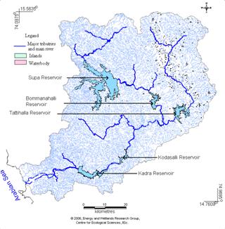
Figure 2 : Drainage Network in Kali River Basin
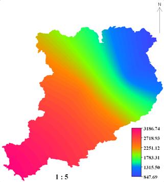
Figure 3 : Mean annual rainfall for Kali river basin from 1901-1987
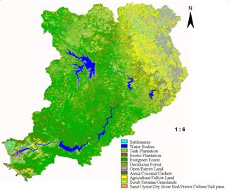
Figure 4 : Land cover classification of Kali River Basin
Figure 5 shows a part of Kali river as seen from Hankon village. The river records the presesnce of around 133 water birds as well as aquatic organisms. Bhat (2001) has reported an endangered fish species Horabagrus brachysoma from the River Kali near Kadra Dam. The fish has been reported only from Kali and Aghanashini basin and in the south it’s record comes only from Kerala skipping the two southern coastal districts of Karnataka. The place also marks the upper distribution limit for many of the endemic birds and amphibians of Western Ghats.
Considering the ecological status of the river Kali the proposed seventh dam near Dandeli for generating 18 MW electricity was kept in abeyance. The withdrawl of water by Bharat Sugar mills situated downstream to Dandeli was protested by local people and an NGO. (http://www.indiaenvironmentportal.org.in/node/38942). The West Coast Paper Mill established in the year 1955 having approved production capacity of 1, 19,500 tones per annum is one of the biggest polluter of River Kali. (http://www.narmada.org/related.issues/kali/workshop/wcpm.dossier.html). Figure 6 gives the evidence of illegal sand mining along the bank of River Kali.
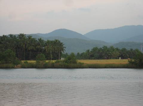
Figure 5: Kali River Basin ()
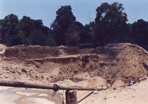
Figure 6 : Sandminig at Chandewadi
Source : Parisarama Samrakshana Kendra