- INTRODUCTION
Thirthahalli taluk (area:1254 sq.km) is situated towards the south-west of Shimoga district between lat. 13°27’22” to 13°55’27” and long. 75°01’57” to 75°30’42”. It is predominantly a hilly taluk right in the middle of central Western Ghats at a mean altitude of 603 m above the msl. Whereas most high rising hills are within 750 m, Heggargudda hill range, covered mostly by Kurnimakki-Halmahishikan, has its summit at 850 m. The taluk is rich in water courses and is drained mainly by the Tunga River and its smaller tributaries and streams. Most of the forest clad hills are associated with such water courses which along their passages through narrow valleys irrigate rice fields and arecanut gardens. The hill ranges of Thirthahalli, which also include the Agumbe Ghat, famed as one of the highest rainfall areas of India, much of it was clad in extremely rich rain forests of central Western Ghats is, is at the heart of the watershed for good part of Karnataka because of the Tunga-Bhadra River. The taluk, as per 2001 Census, had a population of 143,207 persons. Majority of them (128,399 persons) residing in rural areas. The livestock population (1993 census) was quite high at 144,299.
-
Abundance of tanks and streams: Thirthahalli taluk is rich in water resources, especially in streams, compared to the drier eastern portions of Shimoga district. Numerous streams which originate in the hills of the taluk rush through rugged terrain before entering narrow valleys cultivated with gardens and rice fields. The Tunga River that winds its way through in between hills receives most of these streams. In addition there are 741 tanks, most of them built along the stream courses generations back. Gross area irrigated by the tanks in the taluk amounts to 7328 ha, and net irrigated area is 6911 ha. Net area irrigated in the taluk, from all sources, is 11537 ha which highlights the richness of water resources.
-
Rainfall: Thirthahalli, is one of the rainiest taluks in Shimoga district. Agumbe towards the south-west of Thirthahalli is one of the rainiest places in India. The taluk has a normal average rainfall of 3042 mm/yr. It received 2938 mm of rainfall during 2010-11, as shown in the Table: 1
Table 1: Actual and normal rainfall in Thirthahalli taluk for 2010-11
| Months |
Actual monthly rainfall –mm |
Normal monthly rainfall-mm |
| January |
1 |
6 |
| February |
2 |
0 |
| March |
5 |
7 |
| April |
35 |
37 |
| May |
100 |
62 |
| June |
562 |
521 |
| July |
1119 |
890 |
| August |
728 |
866 |
| September |
196 |
338 |
| October |
140 |
169 |
| November |
41 |
146 |
| December |
9 |
0 |
| Total |
2938 |
3042 |
-
Cultivation: Total cropped area in the taluk, in the year 2010-2011 was 25,879 ha, approximately about 20% of the total area of the taluk. Most details on area under various notable crops are given in the Table 2. Paddy occupies most of the cultivable land. Arecanut, coconut, banana, sapota, pepper, cardamom and cashew are the notable horticultural crops. Details regarding the output of various important crops are given in the Table 3.
Table 2: Area under various crops in 2010-11
| Crops |
Area (ha) |
| Foodgrains (mainly paddy and just 3 ha of maize) |
13820 |
| Sugarcane |
54 |
| Fruit crops |
1209 |
| Pulses |
53 |
| Oil seeds |
129 |
| Horticultural crops |
1209 ha (4.67%) |
Table 3: Production details of horticultural crops (in tons) in Thirthahalli taluk
| Crops |
Production in tons |
| Banana |
16,310 |
| Mango |
210 |
| Sapota |
510 |
| Coconut |
69 lakh no. |
| Arecanut |
9338 |
| Pepper |
65 |
| Cardamom |
8 |
| Cashew |
648 |
- FOREST VEGETATION
With the high rainfall in the taluk one can expect tropical evergreen forests everywhere. But actually we find mosaic of various kinds of forests. It is apparent that the original primary forests have given way to secondary forests in most places because of human impact. Pascal et al (1982) considers the main forest type of the taluk as Low elevation (disturbed) evergreen and semievergreen and their various secondary and degraded stages. More towards the east of the district, because of relatively less rugged terrain and larger cultivable areas associated with more populated villages and declining rainfall the forests are more susceptible to desiccation. Secondary moist deciduous forests form a mosaic with cultivation areas, savannas and scrub. Savanna type formations which are grassy lands with isolated trees are created by humans through fire and felling, and used for cattle grazing and meeting local biomass needs. Annual summer fires, often set on by humans, especially for burning bushes and dry litter arrests regeneration of evergreen trees in the secondary moist deciduous forests. The degraded stages of all the above types of forests in the form of scrub, isolated shrubby areas etc. are found closer to human habitations.
Case stdy-1: KURNIMAKKI-HALMAHISHIKAN
Kurnimakki-Halmahishikan (kans are known locally usually by the name of the villages adjoining them, unless there is any other recognized name) in the taluk of Thirthahalli in Shimoga district was studied in the month of April, 2012, mainly from the vegetational angle and for cognizance of threats facing it. The kan is said to be about 1000 hectares and situated between lat. 13.68°-13.73°N and 75.29°-75.35°E. It is not in a single piece but distributed in several survey nos. There is considerable confusion on the demarcation of the boundaries of the kan due to encroachments, conflicting claims of ownership and other practical problems. Looking at all the ancient maps available the kan boundaries need to be more precisely demarcated. Shimoga and Chikmagalur districts were part of erstwhile Mysore State. Kan lands were recognised by the State Forest Department till almost 1970. But after that those survey numbers were merged in Reserved Forests and other kinds of forests including Minor Forests, State forests and District forests (Gokhale et.al, undated). A Google Earth image of the kan and associated landscape elements/villages is given in the Figure 1. The study localities in Halmahishi, Bekshikenjigudda and Kesagaru villages are shown in them. Evergreen to semi-evergreen forests and secondary moist deciduous forests were the main forest types encountered. The geographical coordinates of study sites are shown in the Table 4.
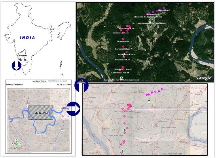
Figure 1: Location, topographic, and vegetational features and forest sampling sites. The presence of Syzygium travancoricum, Critically Endangered tree in Kunikundur, Kurnimakki-10 and Kurnimakki-16. The passage of Tunga River encircling three sides of the kan is notable
Fragmentation of vegetation: The kan forests were praised in the past for their unique evergreen vegetation of lofty trees, rich, moldy soils, fire security, as source of perennial streams and production of various products in demand for human subsistence, especially as centres of pepper production, a commodity that commanded high prices worldwide. Today, a close look at the Kurnimakki-Halmahishi kan on the ground or using aerial imageries, reveal a shocking spectacle of high degree of forest fragmentation. The composition of the landscape elements of the kan does not conform to the past descriptions of such sacred forests from central Western Ghats, being today an assemblage of relics of the evergreens forming an non-cohesive mix with various degraded stages including scrub and periodically fire affected areas. It appears that many a stream originating in the kan get dried up in the summer months resulting in abandonment of the minor tanks constructed along their courses, thus obviously, with adverse consequences on farming downstream and water-flow into the Thunga River diminished. Such severe human induced changes in the evergreen forests of Western Ghats are bound to have cascading consequences on human welfare in the Deccan plains mainly because of reduced water flow in the east-flowing rivers. The condition of the forested terrain, the portion mostly falling in the erstwhile spread of the kan area, as depicted in the Forest Map of South India (Pascal et al., 1982) is shown in the Figure 2. (The legend for the map covers more kind of vegetational types than shown in the selected block)

Figure 2: Vegetation types of Kurnimakki-Halmahishi kan based on Pascal. Degradations of evergreen forests have created an assortment of patches
- Land use Land cover analysis of Select Kan forests in Shimoga
Land use land cover (LULC) information of a region depicts the status of a landscape for environmental progression and sustainable development. Land cover configuration is stated as a unified reflection of the existing natural resources, dynamic natural processes whereas land use refers to the human induced changes in the land cover. The main effects of human activities on the environment are land use and resulting land cover changes. Such changes impact the capacity of ecosystems to provide goods and services to the human society. Human induced land cover change such as for agricultural expansions have caused large scale deforestation leading to soil erosion, watershed degradation, reduced biodiversity, and agrochemical pollution. In forest dominated landscapes fragmentation issues of prominence seem to relate typically to deforestation and loss of forest cover over a period of time. Monitoring these changes isessential for sustainable management of the natural resources. It has become an essential to integrate the patterns of land cover change with the processes of land use change by identifying various drivers for the change process.
Tropical deforestation, rangeland modification, agricultural area shrink and urbanization are the major land-use and land-cover changes around the globe (Geist and Lambin, 2001). The driving force of land-use/cover change vary and their dynamic interactions result in diverse change and trajectories of change, depending upon the specific environmental, social, political and historical context from which they arise (Meyer and Tuner II, 1992). The resulting changes from these drivers exist as a complex between subtle modification and total conversion as seen in a change in forest density and forest to agricultural land or urban area (Geist and Lambin, 2001; Veldkamp and Lambin, 2001). The complexity of land use land-cover changes is illustrated by functional differences within types of land cover, structural variance between types of land-cover change, with regards to spatial arrangement and temporal pattern of change (Giest and Lambin, 2001).
Availability of multi-resolution temporal remote sensing (RS) data has aided in monitoring larger areas at various spatial and spectral resolutions. Remote sensing data along with GIS (Geographical Information Systems), GPS (Global positioning system) and other collateral data (spatial as well as statistical) help in effective land cover analysis (Ramachandra & Kumar, 2004; Ramachandra et al., 2009). Mapping, quantifying, and monitoring the physical characteristics of land cover has been widely recognized as a key element in the study of regional and global changes (Nemani & Running, 1996). The objectives of this work is
- Classification of multi-temporal RS data to obtain LU LC map.
- Multi-temporal analysis for characterise the type and extent of fragmentation or loss of vegetation cover, Visualising the consequences of changes in the region.
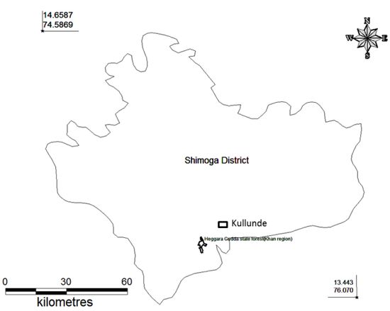
Figure 3: Shimoga district with kans
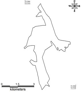
Figure 4: Halmahishi kan -Study area
Area lies between long 74.29440 Nto 75.33380 E and lat 13.74740 E to 13.71330 N in the district of Shimoga, Karnataka (state), India. This region is very near to the Tunga River and having the vegetation cover ranges from Evergreen to semi evergreen with a smaller amount of moist deciduous. The region is very rich in its biodiversity and a hot spot for high endemism. The agriculture and coffee estates are the main drivers for the deforestation in the region. The region covers Kudamalgi, Chicksangudi, Muttur, Dabbangadde, Halmahishi viilages of Thirthahalli taluk. Remote sensing (RS) data used in the study include Landsat TM (1989), IRS (2001, 2010), and Google Earth (http://earth.google.com). The Landsat data is cost effective, with high spatial resolution and freely downloadable from public domains like Glcf (http://glcfapp.glcf.umd.edu:8080/esdi/index.jsp) and USGS (http://glovis.usgs.gov/). The summery characteristics of datasets used in the current study are summarized in Table 4. Besides remote sensing data, many other data sources were used in the study. Topographic maps provided ground control points to rectify remotely sensed images and scanned paper maps.
Table 4: Data used in the study
| Data |
Sensor |
Year |
Resolution (M) |
| Landsat |
TM |
1989 |
28.5 |
| IRS |
Lis3 |
2001 |
23 |
| IRS |
Lis4 |
2010 |
5 |
Figure 5 explains the method adopted for land cover and land use analysis. The RS data of different sensors of Landsat and IRS satellites were acquired. The remote sensing data requires the preprocessing stages like atmospheric correction and geo correction in order to enable correct area measurements. Geometric correction is done by using ground control points collected from field study and Landsat data is resampled to 30 meters. The resampling is required because of the dissimilar spatial resolutions of Landsat sensors. The field investigation is carried out for intensive ground-truth studies during pre-monsoon and post-monsoon seasons. The geographic coordinates of a land cover classes are determined by using GARMIN Global Position Systems (GPS), which provides an advantageous (Zhao et al., 2003). To obtain historical land-cover data, interviewees and group discussions are conducted with farmers and forest officials at different locations in the study region.

Figure 5: Land cover and land use analysis - method
Land cover analysis was done using NDVI (Normalized Difference Vegetation Index). Calculation of NDVI for Multi-temporal data is advantageous in areas where vegetation changes rapidly. Among all techniques of land cover mapping NDVI is most widely accepted and applied (Weismiller et al., 1977, Roy et al., 2002; Ramachandra et al., 2009). NDVI for a given pixel always result in a number that ranges from minus one (-1) to plus one (+1).
NDVI was calculated using Eq. (1)
NDVI = (NIR-R) / (NIR+R) … (1)
Land use analysis was done using supervised classification scheme with selected training sites. Maximum Likelihood algorithm is a common, appropriate and efficient method in supervised classification techniques by using availability of multi-temporal “ground truth” information to obtain a suitable training set for classifier learning. GRASS GIS (Geographical Analysis Support System)software is used for the analysis, which is a free and open source software having the robust support for processing both vector and raster files accessible at http://wgbis.ces.iisc.ac.in/grass/index.php. An accuracy assessment is done to assess the quality of the information derived from remotely sensed data by a set of reference pixels. These test samples are then used to generate the error matrix (also referred as confusion matrix) kappa (κ) statistics and producer's (PA) and user's accuracies (UA) to assess the classification accuracies. Accuracy assessment and kappa statistics are included in table 7.
Results: Land cover analysis was done by computing Normalized Difference Vegetation Index (NDVI) NDVI is based on the principle of spectral difference based on strong vegetation absorbance in the red and strong reflectance in the near-infrared part of the spectrum. Vegetation index differencing technique was used to analyze the amount of change in vegetation (green) versus non-vegetation (non-green) with the two temporal data by considering 1989 as a base. Figure 6 illustrates the land cover dynamics. The vegetation cover has decreased from 79.94 % to 69.91 % due to land encroachments for agricultural activities. Table 5 explains the land cover change with respect to each year considered in the study.

Figure 6: Land cover dynamics
Table 5: Land cover changes during 1989 to 2010
| Year |
Vegetation (%) |
Non Vegetation (%) |
| 1989 |
79.94 |
20.06 |
| 2001 |
76.75 |
23.23 |
| 2010 |
69.91 |
30.01 |
Temporal land use changes are shown in the figure 7 at landscape level from 1989 to 2010 carried out by using remote sensing data. Table 6 lists the land use changes with respect to time. The area of forest is decreased from 79.59% (1989) to 68.41% (2010), whereas agricultural land is increased from 20.41% to 29.62%. This illustrates the conversion of land for agricultural activities. The accuracy of the classification ranges from 87.38 % to 92.47% (Table 8).
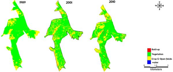
Figure 7: Land use dynamics during 1989-2010
Table 6: Land use
| Year |
1989 |
2001 |
2010 |
| Category |
Ha |
% |
Ha |
% |
Ha |
% |
| Built-up |
0.00 |
0 |
20.58 |
2.09 |
20.5781 |
1.96 |
| Vegetation |
782.29 |
79.59 |
718.28 |
73.08 |
716.4776 |
68.41 |
| Water |
0.00 |
0 |
1.19 |
0.12 |
0 |
0 |
| Cropland &open fields |
200.52 |
20.41 |
242.75 |
24.71 |
245.7443 |
29.62 |
Table 7: Accuracy assessment
| Category |
1989 |
2001 |
2010 |
Overall Accuracy |
Kappa |
| PA |
UA |
PA |
UA |
PA |
UA |
| Built-up |
62.69 |
40.83 |
78.23 |
93.02 |
89.18 |
100.00 |
87.38 |
0.81 |
| Water |
99.99 |
99.86 |
98.98 |
79.49 |
91.42 |
92.44 |
91.25 |
0.86 |
| Cropland |
79.60 |
97.29 |
99.47 |
93.84 |
97.58 |
98.46 |
92.47 |
0.88 |
| Evergreen forest |
94.78 |
100.00 |
99.84 |
100.00 |
97.86 |
81.39 |
87.38 |
0.81 |
ii. Vegetation studies
Vegetation was studied in 26 sampling localities within the kan using Point-centred quarter method. The geographical coordinates of the localities sampled are shown in the Table 8.
Table 8: The localities within the kan chosen for quantitative sampling of forest
| Sl |
Localities visited |
LONGITUDE |
LATITUDE |
| 1 |
Kurnimakki Kan-1 |
75.3079 |
13.7075 |
| 2 |
Kurnimakki Kan-2 |
75.3102 |
13.7091 |
| 3 |
Kurnimakki Kan-3 |
75.3108 |
13.7092 |
| 4 |
Kurnimakki Kan-4 |
75.3113 |
13.7086 |
| 5 |
Kurnimakki kan-5 |
75.3107 |
13.7081 |
| 6 |
Kurnimakki kan-6 |
75.3103 |
13.7074 |
| 7 |
Kurnimakki kan-7 |
75.3087 |
13.7067 |
| 8 |
Kurnimakki kan-8 |
75.3107 |
13.7081 |
| 9 |
Kurnimakki Kan-9 |
75.3088 |
13.7017 |
| 10 |
Kurnimakki Kan-10 |
75.31 |
13.6997 |
| 11 |
Kurnimakki Kan-11 |
75.309 |
13.6989 |
| 12 |
Kurnimakki Kan-12 |
75.3089 |
13.6978 |
| 13 |
Kurnimakki Kan-13 |
75.3088 |
13.6943 |
| 14 |
Kurnimakki Kan-14 |
75.3085 |
13.6937 |
| 15 |
Kurnimakki Kan-15 |
75.3076 |
13.6931 |
| 16 |
Kurnimakki Kan-16 (S. travancoricum) |
75.3081 |
13.6905 |
| 17 |
Kurnimakki Kan-17 |
75.3077 |
13.6898 |
| 18 |
S. travancoricum (Wadape) |
75.3089 |
13.6989 |
| 19 |
Debanagadde |
75.3088 |
13.7044 |
| 20 |
Syzygium travancoricum (Kunikundur) |
75.3186 |
13.711 |
| 21 |
Halmahishi -1 (Chaginakudi kere) |
75.3177 |
13.7133 |
| 22 |
Halmahishi-2 |
75.3185 |
13.7134 |
| 23 |
Halmahishi-3 |
75.3198 |
13.7142 |
| 24 |
Halmahishi-4 |
75.3212 |
13.7145 |
| 25 |
Halmahishi-5 |
75.3227 |
13.7147 |
| 26 |
Halmahishi-6 |
75.324 |
13.7157 |
iii. Tree species in evergreen-semievergreen forest type
Lofty evergreen trees of 25 to 30 m height were quite many in the forest and belonged to species such as Aphanantha cuspidata, Canarium strictum (Kan: Karidhupa), Mangifera indica, Syzygium hemisphericum, S. travancoricum etc.Evergreen trees of the second level of general heights from 15-25m include Actinodaphne hookeri, Aglaia roxburghiana, Anthocephalus kadamba, Beilsmeida fagifolia, Dimocarpus longan, Ficus callosa, Holigarna ferruginea, Hopea ponga, Olea dioica, Syzygium cumini etc. Evergreen trees of still smaller stature include Aporosa lindleyana, Ixora brachiata, Knema attenuata, Litsea wightiana, Vepris bilocularis etc. We could list 46 tree species from this type of forest. Some deciduous species are also found in this type viz. Careya arboa, Lagerstroemia microcarpa, Stereospermum personatum, Terminalia paniculata, T. bellirica, Vitex altissima, Xylia xylocarpa; Zanthoxylum rhetsa, etc. The secondary deciduousforests within the kan and their peripheral areas are obviously due to forest fragmentation through cutting and burning. They have, in addition to the leaf shedding trees mentioned above also have Madhuca latifolia, Bombax ceiba, Terminalia paniculata, Firminia colorata etc. Altogether only 25 tree species were found in the deciduous forests, which include a small number of tolerant evergreens such as Olea dioica, Aporosa lindleyana, Syzygium cumini, Alstonia scholaris etc. Two patches of forests, one of evergreen remains and the second of moist deciduous kind (secondary) are shown in the Figure 8. The Shannon diversity index for trees was found to be higher (3.45) for the evergreen dominated patches than for the deciduous (2.79) (Figure 9 Shannon diversity). Details of tree species inventorised from the sample points of evergreen and deciduous areas are given in Figure 10, along with estimated basal areas/ha in both.
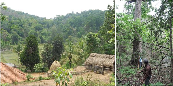
Figure 8: Relic evergreen forest patch and a farmland below. Water input from the kan is vital for cultivation; R. Vegetation survey in a secondary moist deciduous forest within the kan
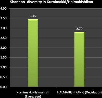
Figure 9: Shannon diversity index for evergreen dominated and deciduous dominated areas
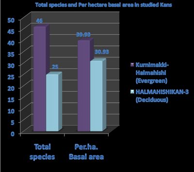
Figure 10: Tree species inventorised for evergreen sample points and deciduous areas and basal area estimated/ha for both.
-
Tree density/ha: The evergreen-semi-evergreen forests had more tree numbers/ha in the kan at 234/ha compared to the moist deciduous patches at 181/ha. The estimated number was lower for both types of forests than any good low elevation Western Ghat forests where the number could be >300 to 500/ha. The kan forest particularly, belonging to the traditional category of sacred forest, is expected to have more number of trees. Ever increasing human impact and conflicting claims on ownership, diluting the authority of the Forest Department, may be a pertinent factor for less than expected number of trees.
-
Basal area of trees: Basal areas of trees/ha was calculated based on the girth measurements taken for the sampled trees. The basal areawas found to be 39.93 m²/ha for evergreen/semi-evergreen areas and 30.93 m²/ha for deciduous forest areas. This lowered basal area of a sacred forest, which reflects particularly a thinning of the forest in the catchment of the Tunga River, does not augur well for hydrology of the region as a whole. The fate of the other kans in Thirthahalli taluk does not appear to be better, as the category of kan forest itself is fading away from the face of the taluk, which had once 436 kans on the record.
-
Evergreenness and endemism of trees
The Western Ghats, along with Sri Lanka, constitute one of the 34 Global Biodiversity, on account of high species diversity, high degree of species endemism as well as heavy human impact on the ecosystems. Endemism in any group of plant or animal is typically linked to levels of tree endemism in the forests. If there is high percentage of endemic trees in an area, endemism among lower plant groups and in the animal community is also expected to rise. The rise in percentage of Western Ghat endemism in relation to increase in percentage evergreen trees in the community is evident from the Figure 11.

Figure 11: Tree endemism in evergreen-semi-evergreen forests versus deciduous forests
Figure 12 depicts that the evergreen-semi-evergreen forest patches considered collectively for percentage of evergreen trees, showing a higher result (almost 85% individuals belonging to evergreen type) account for higher Western Ghat tree endemism (32%), compared to the predominantly deciduous patches collectively accounting for only 41% evergreenness having barely 10% endemics. Some endemics survive there because these deciduous forest patches occur in an evergreen zone of higher rainfall, and some of the desiccation and large gap tolerant trees like Lagerstroemia microcarpa (deciduous) and Taberna-montana coronaria, an understorey plant are considered endemics.One of the first casualties of gross human interference with humid forest ecosystem of the Western Ghats would be disappearance of the most sensitive endemic species. The kan forests, in the pre-colonial days would have been important local centres of plant and animal endemism, as they were considered sacred and there was strong taboo on tree cutting in such forests. Notable among the endemic trees were Calophyllum apetalum, Cinnamomum malabathrum, Holigarna arnottiana, H. ferruginea, Hopea ponga, Mastixia arborea, Polyalthia fragrans etc.
-
Swamps with Syzigium travancoricum: Tree back to life from fear of extinction: To our great surprise in some of the swampy water bodies associated with the kan we could see small populations of Syzygium travancoricum, an evergreen, endemic tree of the Western Ghats, which has been Red Listed as Critically Endangered by the IUCN. Our discovery of this majestic tree in the Kurnimakki-Halmahishikan, while an altogether new report of such a species from Shimoga district itself, underscores the importance of preservation of kans as ‘Heritage Sites’ from cultural, biological angles. The tree was considered extinct from its original known home range from Travancore Western Ghats, after its first discovery by Bourdillon in 1894, as it was not observed later, probably due to its rarity. Subsequently it was rediscovered from southern Western Ghats in the early 1990’s. Its rare occurrence associated with swampy places in some of the evergreen kan forests of Ankola and Siddapur, 700 km north of Travancore came as a surprise, while this finding highlights the role of kans as centres of biodiversity conservation in otherwise human impacted landscapes (Chandran et al., 2008). As our primary objectives for the study also included bringing to light rare elements of biodiversity conserved through generations in the system of kans, we went out of way, beyond the domains of random sampling, so as to draw attention to this Critically Endangered species in its imperilled swampy habitat. Fire damages and the recent cuttings of this threatened species is a matter of grave concern (Figures 12 and 13)
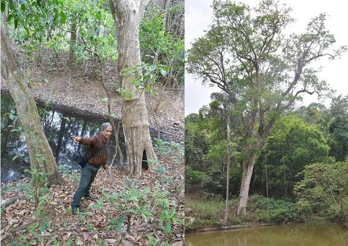
Figure 12: Syzygium travancoricum close to water bodies

Figure 13: Cutting of Syzygium travancoricum in a relic primary evergreen forest patch inside the kan
-
Importance value index (IVI): The IVI of evergreen and deciduous species, listed in Table 9, show the contrast in the vegetation. Evergreens are, understandably, dominating the evergreen forest areas. Syzygium travancoricum dominated swamps were specially studied with greater efforts, because of the rarity of the species (Critically Endangered as per IUCN Red List), as already explained above. A lofty and buttressed evergreen tree species, Aphananthe cuspidata (Figure 14)has the highest IVI in the forest. The high occurrence of evergreen forest disturbance indicator and more light loving tree Aporosa lindleyana, although itself an evergreen, shows the kan forest is under stressed conditions. There are, however, several individuals of Canarium strictum (Figure 14), in the evergreen forest which is one of the good indicators of the evergreen high forest for the region.
Table 9: IVI of evergreen and deciduous species
|
Evergreen tree dominated forest patches |
Deciduous trees dominated forest patches |
| Sl |
Species |
IVI |
Species |
IVI |
| 1 |
Aphana nthe cuspidata |
47.70 |
Xylia xylocarpa |
67.99 |
| 2 |
Syzgium travancoricum |
33.57 |
Olea dioica |
35.89 |
| 5 |
Aporosa lindleyana |
14.62 |
Syzygium cumini |
30.69 |
| 3 |
Mangifera indica |
14.39 |
Term inalia bellirica |
21.40 |
| 6 |
Dimocarpus longan |
12.94 |
Alstonia scholaris |
13.20 |
| 4 |
Canarium strictum |
12.06 |
Terminalia paniculata |
11.27 |
| 8 |
Term paniculata |
10.19 |
Vitex altissima |
10.84 |
| 7 |
Hopea ponga |
9.96 |
Dimocarpus longana |
10.54 |
| 9 |
Terminalia bellirica |
9.52 |
Spondias acuminata |
10.35 |
| 10 |
Canthium dicoccum |
8.20 |
Ervatamia heyneana |
8.89 |
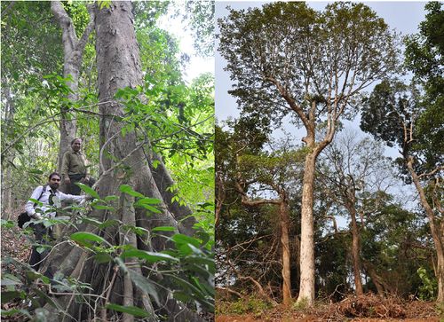
Figure 14: Aphananthe cuspidata and Canarium strictum, dominant evergreen species
-
Species-richness: family-wise: The details of species numbers, family-wise, are given in the Figure 15. Rubiaceae and Rutaceae were the most specious families, followed by others. The details of species observed during the short term survey, including their geographic distribution, are given in the Annexure 1.
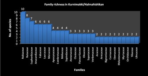
Figure 15: Vegetation richness in Kurnimakki/Halmahishi Kan
iV. Decline in hydrological value
The concept of kans as important watershed areas diminished in due course with major changes in the vegetation, especially, with the decline of evergreens and the entry of fire to clear portions of the kans where subsequently only deciduous woods regenerated causing exposure of rocks underneath and compacted and eroded soils. Subsequently many tanks, especially smaller ones, got silted up and their utility from irrigation point stopped. The Figures (figure 16) of a small, silted tank (which is still a refuge for several Syzygium travancoricum trees), adjoining a fire burned forest, and subsequently abandoned water canal are given here.
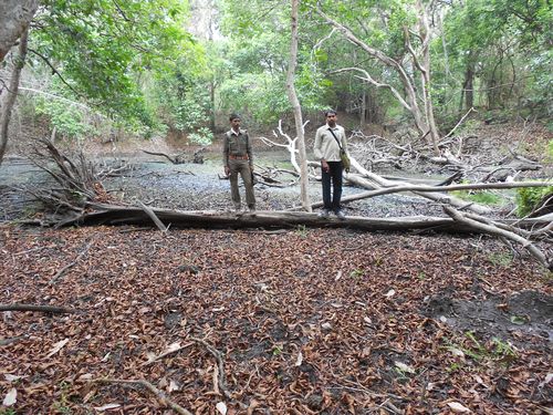
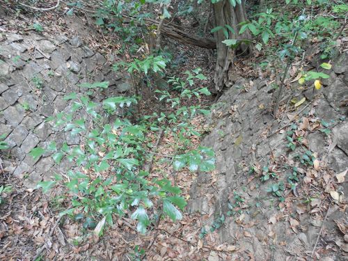
Figure 16: A silted water tank with dead and fallen Syzygium travancoricum (on account of fire) and an abandoned water canal within the kan
v. A sacred kan on the wane
The kan forests of central Western Ghats, were important natural sacred sites and cultural centres of the pre-British village communities. They were like similar natural sacred sites elsewhere in the Western Ghats, viz. the devrais of Maharashtra, devarakadus of Coorg or kavus of Kerala. At one time, they rose majestically in the horizons, covering large areas in the high places of the malnadu village landscapes, surrounded by cultivations, timber rich secondary forests, and savannized grazing areas. Perennial streams gushing out of these sacred forests were often embanked to make irrigation tanks. The run of numerous such streams ended with their merger with the rivers, which owed for their perennial nature to such streams which flowed even during the hot and rainless months. Unfortunately, the kans did not merit consideration as sacred places of village communities under the British rule and also after Independence. There were only stray references to the sacredness of the kans by some officers of the British regime. And as such the kans were simply viewed as dense evergreen forests important for pepper, toddy and sugar from the palm Caryota urens and for few other items of commercial or subsistence values. In Shimoga district, particularly, many kans were brought under the jurisdiction of the Revenue Department, which conveniently allotted kan lands for meeting various non-forestry purposes such as for growing coffee, expansion of cultivation, for grazing purposes and numerous others, inconsiderate and negligent of the rare species they conserved and also of their crucial hydrological importance. The Government also conceded large portions of kans on long leases to the Mysore Paper Mills for growing industrial woods like Eucalyptus and Acacia spp. after clearing the natural vegetation (Annexure 2).
Continuation of sacred sites
As far as sacredness of the Kurnimakki-Halmahishi kan is concerned we need to state that there are still several sites within the kan which are abodes of village deities; for instance, Chowdi, Siddaradevaru, Betedevaru and Nagaradevaru are names of some such deities of Kunikundur village. The abode of a deity within the kan (represented by crude stones only) is shown in the figure 17. Other villages also have their deities still associated with the kan.
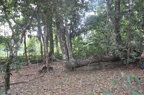
Figure 17: A sacred spot within the kan, where the deity is worshipped
Case study II. KULLUNDEKAN
Kullundekan in the taluk of Thirthahalli in Shimoga district was studied in the month of April, 2012, mainly from the vegetational angle and for cognizance of threats facing it. The kan, situated between lat. 13.76° & 13.81° N and 75.43190 Nto 75.42880 E , is spread over in the Survey nos. 25, 27, and 29 covering an area of altogether 453.86 ha. Lack of consolidation of forest areas and conflicting claims of ownerships, allotments for non-forestry purposes by the Revenue Department come in the way of precise boundary identification for Kullundikan. Most other kans of Shimoga district are also plagued with similar problems. Shimoga and Chikmagalur districts were part of erstwhile Mysore State. Kan lands were recognised by the State Forest Department till almost 1970. But after that those survey numbers were merged in Reserved Forests and other kinds of forests including Minor Forests, State Forests and District forests (Gokhale et.al, undated). A Google Earth image of the kan and associated landscape elements is given in the Figure 18. The study localities mainly covered Kullundi, Singanabidare, and Garaga villages. The vegetation ranges from evergreen to semi-evergreen and secondary moist deciduous forests, in addition to their degradation stages ultimately resulting in small bare areas and scrub. The geographical coordinates of 16 study localities, where vegetation was sampled, are given in the Table 10.

Figure 18: Location, topographic, and vegetational features and forest sampling sites.
-
Fragmentation of vegetation: The kan forests were praised in the past for their unique evergreen vegetation of lofty trees, rich, moldy soils, fire security, as source of perennial streams and production of various products in demand for human subsistence, especially as centres of pepper production, a commodity that commanded high prices worldwide. The composition of the landscape elements of the kan does not conform to the past descriptions of such sacred forests from central Western Ghats, being today an assemblage of relics of the evergreens forming an non-cohesive mix with various degraded stages including scrub and periodically fire affected areas. Severe human induced changes in the evergreen forests of Western Ghats are bound to have cascading consequences on human welfare in the Deccan plains mainly because of reduced water flow in the east-flowing rivers. The condition of the forested terrain, the portion mostly falling in the erstwhile spread of the kan area, as depicted in the Forest Map of South India (Pascal et al., 1982) is shown in the Figure 19. (The legend for the map covers more kind of vegetational types than shown in the selected block). Bulk of the forest is evergreen and a portion was once dominated by Dipterocarpus indicus of the climax evergreen type formation of the lower altitudes. However, many mighty trees of the species were cut down for planting coffee and for forest based industries in the past. Many changes appear to have taken place after the preparation of the vegetation map by Pascal, due to land allotments for non-forestry purposes and due to other human interventions.
-
Quantitative studies
Vegetation was studied in 16 sampling localities within the kan using Point-centred quarter method. The geographical coordinates of the localities sampled are shown in the Table 10.
Table 10: Study localities of forest sampling
| Sl |
NAME |
LONGITUDE |
LATITUDE |
| 1 |
Kulundikan-1 |
75.4319 |
13.7911 |
| 2 |
Kulundikan-2 |
75.4312 |
13.7915 |
| 3 |
Kulundikan-3 |
75.4288 |
13.7917 |
| 4 |
Kulundikan-4 |
75.4286 |
13.7913 |
| 5 |
Kulundikan-5 |
75.4285 |
13.7911 |
| 6 |
Kulundikan-6 |
75.4267 |
13.7916 |
| 7 |
Kulundikan-7 |
75.4315 |
13.7951 |
| 8 |
Kulundikan-8 |
75.4307 |
13.7954 |
| 9 |
Kulundikan-9 |
75.4306 |
13.7956 |
| 10 |
Kulundikan-10 |
75.4305 |
13.7958 |
| 11 |
Kulundikan-11 |
75.4349 |
13.7926 |
| 12 |
Kulundikan-12 |
75.4347 |
13.7931 |
| 13 |
Kulundikan-13 |
75.4317 |
13.7940 |
| 14 |
Kulundikan-14 |
75.4315 |
13.7933 |
| 15 |
Kulundikan-15 |
75.4303 |
13.7936 |
| 16 |
Kulundikan-16 |
75.4281 |
13.7956 |
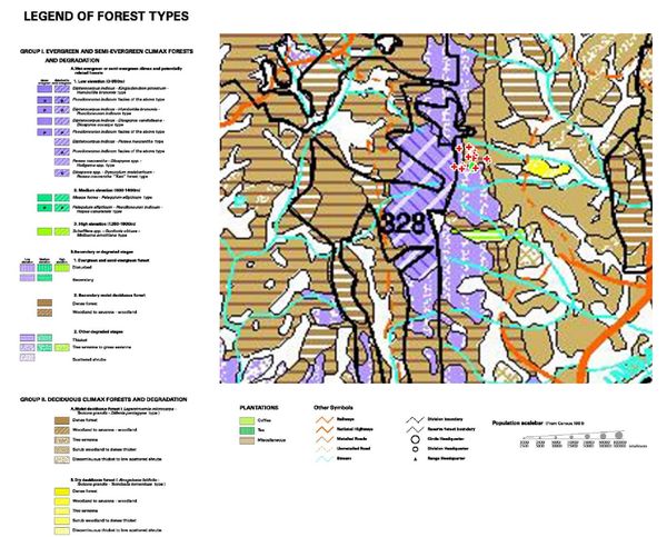
Figure 19: Forest Map of South India (Pascal et al., 1982)
-
Tree species in evergreen-semievergreen forest type
The kan originally had Dipterocarpus indicus and Calophyllum tomentosum dominated climax forests. Clearances have taken place in many places in lands allotted for planting coffee and arecanut, as well as encroachments have happened. The forests would have suffered heavily due to the selection felling of industrial woods during especially 1950’s to early 1980’s, as there were several large canopy gaps. Yet there were many majestic evergreen trees exceeding 30 m in height and of girths exceeding 4-5 m (Figure 20). Of the trees of the emergent type still present in portions of the kan are in addition to D. indicus and C. tomentosum, Ficus nervosa, Ficus callosa, Artocarpus hirsuta, Cyclostemon confertiflorus, Canarium strictum, Bischofia javanica etc, Mangifera indica, Tetrameles nudiflora, Alstonia scholaris etc. The next in order in the height, and belonging to the 20-30 m group were Mimusops elengi, Aphananthe cuspidata, Homalium zeylanicum, Chrysophyllum roxburghii, Strombosia zeylanica, Aglaia roxburgiana, Alseodaphne semecarpifoli etc. Of the still smaller trees of 10-20 m, the notable ones were the palm Caryota urens, Olea dioica, Dimocarpus longan, Pterospermum sp., Sapindus laurifolius etc. Here and there, because of fire and felling deciduous forests of secondary nature have appeared, where the notable species were Lagerstroemia microcarpa, Grewia tilifolia, Spondias acuminate, Terminalia bellirica, T. paniculata, Xylia xylocarpa, Macaranga peltata etc.
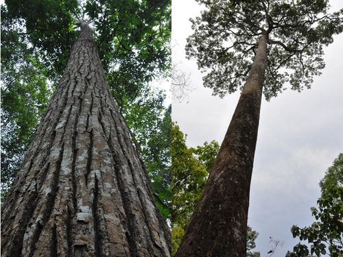
Figures 20: Calophyllum tomentosum and Dipterocapus indicus
Some patches allotted for coffee cultivation (Figure 21) has been planted with coffee after fully or partially clearing the trees, whereas one patch of eight acres, allotted to Sri Chidambara Gowda was seen as such without forest clearance or planting of coffee (Figure 22)
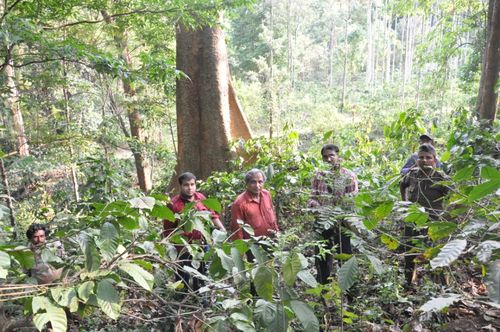
Figure 21: Coffee cultivation in a kan area allotted to private farmer
 for coffee plantation.jpg)
Figure 22: Area allotted (8 acres) for coffee plantation maintained as forest
The secondary deciduousforests within the kan and their peripheral areas are obviously due to forest fragmentation through cutting and burning. These have come through succession in the place of evergreen high forest of the Western Ghats. Among the notable tree species observed were Grewia Lagerstroemia microcarpa, Terminalia bellirica, T. paniculata, Xylia xylocarpa.
Diversity index (Shannon diversity) for tree species for the evergreen forest was highest at 3.11, for the forest patch allotted to private person and protected as such (figure 23). When a climax evergreen forest of Dipterocarpus indicus and Calophyllum tomentosum domination was partially cleared and planted with coffee, despite the isolated towering trees remaining, the diversity index was lower at 2.75. Yet another portion with coffee had reasonably good number of species, although they were of secondary nature and smaller in stature with diversity index at 2.87. The lowest diversity of 1.85 was for the secondary moist deciduous forest.

Figure 23: Shannon diversity index for tree species in four categories of forests, with the intact preserved forest in malki land showing marginally higher diversity.
-
Number of tree species: Part ofKullundekan, partially cleared an panted with coffee, with very large trees still remaining had only 21 species of trees, compared to the intact forest which had 27 species. Another coffee planted area had only 19 species, whereas the deciduous forest had least number as expected (7). Moreover the deciduous patch sampled was too small and degraded and therefore no higher diversity is expected. But opportunistic surveys elsewhere yielded more number of trees in the deciduous forest, the details of which are given in the plant diversity of Kullundikan given as Annexure-3
-
Basal area of trees: Estimated basal areas/ha based on sample surveys of the four patches referred to was highest at 47.2²/ha for the intact forest, followed by 40.34 m²/ha for the coffee area with large proportioned relic trees (Figure 24). Considering the fact that this basal area was for the remnant patch of estimated 69 trees/ha, one could visualize the fact if such a forest were not to be felled for coffee, with 300 plus trees/ha, the basal area/ha could have exceeded 100 m², perhaps the highest for Western Ghat vegetation. Next in importance was the normal coffee planted area without such huge trees and the least was for the deciduous forest.

Figure 24: Tree species numbers and basal area/ha for the forest samples
-
Evergreenness and endemism among trees: Interesting trend is seen in the evergreenness of the forest versus percentage of Western Ghat specific tree endemism (Figure 25). In general, more evergreen a forest is higher is the tree endemism, with the deciduous forest showing zero endemism. This reaffirms the fact clearances of well preserved evergreen forests with high endemism can wipe out endemics altogether on clear-felling and burning, with practically little scope for endemic species recovery in such areas.
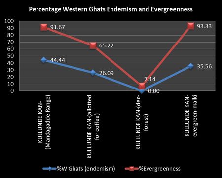
Figure 25: Decline in evergreen trees in a forest causes decline of endemic tree species
-
Importance Value Index
The IVI details of the five most dominant forest tree species from the four localities sampled are given in Tables 11 and 14
Table 11: IVI of a climax relic forest vegetation partially cleared for coffee cultivation
|
KULLUNDI KAN -1 |
| Sl |
Species |
IVI |
| 1 |
Calophyllum tomentosum |
59.29 |
| 2 |
Dipterocarpus indicus |
54.15 |
| 3 |
Ficus nervosa |
20.29 |
| 4 |
Homalium zeylanicum |
19.75 |
| 5 |
Artocarpus hirsuta |
19.15 |
Table 12: IVI of secondary type forest cleared for coffee
|
KULLUNDIKAN-2 |
| Sl |
Species |
IVI |
| 1 |
Alstonia scholaris |
38.07 |
| 2 |
Cyclostemon confertiflorus |
30.38 |
| 3 |
Tetrameles nudiflora |
23.30 |
| 4 |
Sapindus laurifolius |
20.33 |
| 5 |
Syzygium cumini |
19.30 |
Table 13: IVI of Secondary moist deciduous forest
|
KULLUNDE KAN-3 (Deciduous forest) |
| Sl |
Species |
IVI |
| 1 |
Terminalia paniculata |
61.49 |
| 2 |
Xylia xylocarpa |
56.42 |
| 3 |
Terminalia bellirica |
55.62 |
| 4 |
Grewia tilifolia |
53.21 |
| 5 |
Spondias acuminata |
34.81 |
Table 14: IVI of a forest allotted for coffee planting but preserved by the allotted person
|
KULLUNDE KAN-4- evergreen |
| Sl |
Species |
IVI |
| 1 |
Ficus microcarpa |
33.37 |
| 2 |
Calophyllum tomentosum |
26.32 |
| 3 |
Artocarpus hirsuta |
22.04 |
| 4 |
Aglaia anamallayana |
20.86 |
| 5 |
Olea diocia |
18.70 |
The IVI tables clearly reveal that the relic forest has still some unique vegetation with Dipterocarpus indicus and Calophyllum tometosum. The former is an Endangered tree species according to IUCN. Destruction of the climax forest is bound to wipe out such species, as the same is not seen in other forms of land use, including the forest preserved in tact by the person who was granted the same for coffee cultivation. That forest appears to be old growth forest on land cleared in the pre-colonial times, probably for shifting cultivation.