|
Biodiversity through time and space has provided the panorama of the genesis and diversification of various life forms, their interdependence, and link between life and life support systems, triggering a holistic approach to knowledge-building focused on various aspects of human affairs. These areas have already lost vast area of virgin forests as evident from barren hill tops, seasonal streams, local extinction of species, etc. with many still existing as revenue lands waiting to be logged and gone forever. Unplanned developmental activities in the region will further diminish the biodiversity (most importantly to the endemic and endangered species), hydrology and ecology of the region. It is high time for us to understand nature, its importance for our sustainable living and for future generations to come than taking ad hoc decisions to build dams across rivers and inundate the natural resources forever.
Freshwater ecosystems of the tropics and sub-tropics are undergoing rapid deterioration due to developmental pressures, opportunistic exploitation and neglect. The challenging issues here are to improve the current knowledge of its biodiversity so that it would aid in sustainable management of the ecosystem through suitable conservation approaches. The Western Ghats is one among the 34 global hotspots of biodiversity and it lies in the western part of peninsular India in a series of hills stretching over a distance of 1,600 km from north to south and covering an area of about 1,60,000 sq.km. It harbours very rich flora and fauna and there are records of over 4,000 species of flowering plants with 38% endemics, 330 butterflies with 11% endemics, 156 reptiles with 62% endemics, 508 birds with 4% endemics, 120 mammals with 12% endemics (Daniels, 2003), 289 fishes with 41% endemics (Sreekantha et al., 2007) and 135 amphibians with 75% endemics (Gururaja, 2004). Such biodiversity coupled with the higher endemism could be credited to the prevailing climate (higher rainfall, evapotranpiration, etc.), location (mid latitude), topographic, and geological characteristics of the region.
Karnataka state is situated in South-West India. Physiographically the state is demarcated into three different natural zones - Karavali, which is the Coastal Strip between Western Ghats and Arabian Sea which extends for a length of 240 km and has a width of 40-50 km; the Malanad region consisting of Western Ghats chain from where many rivers originate and the inland plain region of Deccan plateau. The Western Ghats region receives moderate to heavy rainfall. Karnataka has one of the highest average elevations of Indian states at 1,500 feet.
The Netravathi river, flowing only in Karnataka state in the western direction, originates at an altitude of 1720m in the Western Ghats region of Kudremukh hill ranges in Chikmagaloor district. Another important river Kumaradhara, originating in the Coorg district joins the Netravathi river in Uppinangadi and then these two rivers flow westwards merging with Arabian Sea near Mangalore. Before joining Kumaradhara river, Netravathi river forms some important tributaries namely - Charmudi hole, Neria hole, Shishla hole, Belthangdi hole, etc. whereas Gundia hole forms an important tributary of Kumaradhara part of Netravathi. A catchment area of size 3,300 sq.km. is drained by river Netravathi and its tributaries and the average annual rainfall received by this area is recorded to be 5000 mm. The Netravathi basin can be divided into three basins namely - Netravathi basin ehich is typically umbrella shaped, Gundia basin and Kumaradhara basin.
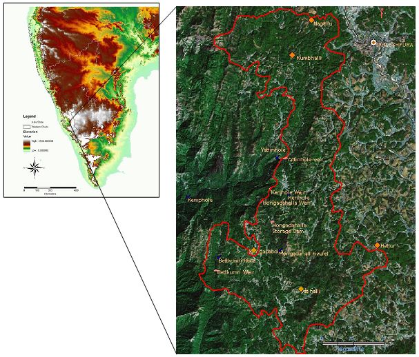
The Gundia River is one of the most important tributaries of river Kumaradhara originating at an elevation of about 1400 m in Saklasheshpura taluka in Hassan district. Gundia River is formed by the streams namely Yettinaholé and Kempholé to which the streams Kadumaneholé and Hongadahallé join in the course. The Gundia catchment region is surrounded Hemavathi river water-shed on its right, Barapole river catchment on its left and Netravathi River on downstream side. The Gundia catchment comes under influence of the South-west monsoon in months of June to September.
Figure 1: Gundia River Basin
The areas selected for development of hydroelectric project also include part of Malnad region of Western Ghats. The Malnad region covers the western and eastern slopes of Western Ghats hving a width of about 100 kms and covering the portions of Shimoga, Chikmagalur, Uttara Kannada, Kodagu and Hassan disticts. The hills of Malnad are thickly forested and receive an average rainfall of 1000 - 3800 mm per annum. Coffee is grown abundantly in this region. The topography of this region is Precambrian with a peninsular gneiss terrain and major rock types are formed by migmatites represented biotite-hornblende gneisses. The migmatites are composed of amphibolites, pyroxene-granolites and calc-granulites.
According to the revised seismic zone map of 2002, the entire Karnataka state is covered by two zones - Zone II and Zone III. The coastal regions are mainly covered under Zone III whereas the plain regions are covered under Zone II. The Gundia Hydel Project Scheme falls under the Zone III with no major earthquake epicenter recorded in past.
GUNDIA HYDROELECTIC PROJECT: The Gundia Hydroelectic Project (GHEP) proposed by Karnataka Power Corporation Limited (KPCL) is situated in the Hassan and South Canara districts about 100 kms east of Mangalore city. Three sages have been proposed for development of this project – first stage would include utilization of water from Yettinahole, Kerihole, Hongadallaha and Bettakumbri streams covering a catchment area of 178.5 sq.km., second stage would include Kumaradhara and Lingath hole covering 78 sq.km of catchment area and third stage would involve 6 streams including Kumarahole, Abilbiru hole, etc. covering a catchment area of 70 sq.km. Figure 2 provides the topography along with the project details.
Figure 2: Topography of the proposed project site.
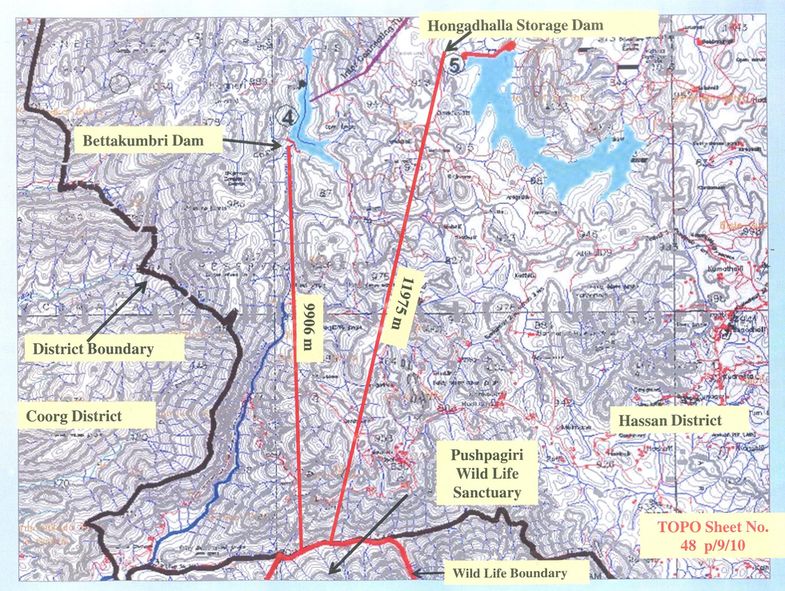
The first part of the project which is in proposal right now aims at construction of weirs at four different streams. The weir site catchments area of Yettinahole is 60.50 sq.km., Kerihole is 27.00 sq.km., Hongadallah is 56.00 sq.km. and of Bettakumbri is 35.00 sq.km. 5 rain gauge stations in Yetinahole, Hongadallah and Bettakumri and 4 rain gauge stations in Kerihole provide the rainfall data of last 14 years.
Figure 3: Plan of GHEP
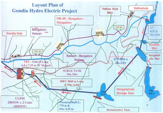
The Gundia Hydroelectric Project aims at production of 200 MW of electricity at the cost of about Rs. 1120 crores. According to the project proposal, about 734 ha. of land will be submerged by this project. The Hongadallah storage dam which was proposed in proposal was cancelled as that region was a reserve forests and the KPCL had applied for construction of remaining part. The total length of tunnels to be constructed in this project for transport of water is 21 kms.
This region harbours many endemic and endangered species. Nearly 36% of the plant species are endemic to Western Ghats, similarly among animals 87% amphibians, 41% fishes are endemic to Western Ghats. More importantly, the presence of four critically endangered and 14 endangered animal species in the region emphasises the unique habitats and ecological niches provided in Gundia region for these animals.
The proposed project is ecologically unsound and economically unviable because of the following reasons:
- The construction of this project will cause large scale land cover changes in Gundia (Section 1)
- The proposed project would deteriorate the biodiversity of the region (Details in Section 2)
- The proposed region is a part of an Elephant reserve and forms a vital link of two Elephant corridors (Details in Section 3).
- The proposed project would cause habitat fragmentation and shrinkage resulting in enhanced the Human - Animal conflicts (Details in Section 3)
- The economic value of the region is clearly higher. The forests are ecologically and economically beneficial to humans (Details in Section 4)
- Alters the hydrological regime – Kumaradhara river, a perennial source of water to Subramanya temple will lose the water source due to diversion to Bettakumri dam. This would hurt the religious sentiments apart from the revenue from ecotourism. Also, due to large scale land cover changes, the catchment yield will dwindle and current perennial streams will become seasonal (as in Sharavathi river basin). This would affect ecosystem people.
The project hence would be ecologically and economically unviable as it would weaken the food and water security of the region. |
