¦ ¦ ¦ ¦ ¦
ENVIS Technical Report 91,   April 2015
ENVIRONMENTAL FLOW ASSESSMENT IN YETTINAHOLE:
WHERE IS 24 TMC TO DIVERT?
1Energy & Wetlands Research Group, Centre for Ecological Sciences, 2Centre for Sustainable Technologies (astra),
3Centre for infrastructure, Sustainable Transportation and Urban Planning [CiSTUP], Indian Institute of Science, Bangalore, Karnataka, 560 012, India.
E Mail: cestvr@ces.iisc.ernet.in; vinay@ces.iisc.ernet.in; bharath@ces.iisc.ernet.in, Tel: 91-080-22933099, 2293 3503 extn 101, 107, 113
Annexure:

Yettinaholé Project, proposed in order to derive water for the people and to recharge the ground water resources of south east Karnataka which is a rain shadow area. The taluks planned for providing drinking water are Sakleshpura, Hassan, Belur, Arsikere, Tiptur, Tumkur, Kortagere, Doddaballapura, Chikkaballapura and Devanahalli taluks of Hassan, Tumkur, Bangalore rural, Kolar and Chikkaballapur districts respectively. The project proposal is to draw the excess runoff water during the monsoon i.e., May to November about 24 TMC of water by construction of check dams, pumping the water in order to cater the demands of the rain shadow regions. The total cost of the project estimated as 12915 crore Rupees. The following as components of DPR were adapted on 6th November 2013.
Phase 1 component comprising of the following:

  • Construction of 8 diversion weirs across Yettinaholé, Kadumaneholé, Keriholé and Hongadahalla stream.
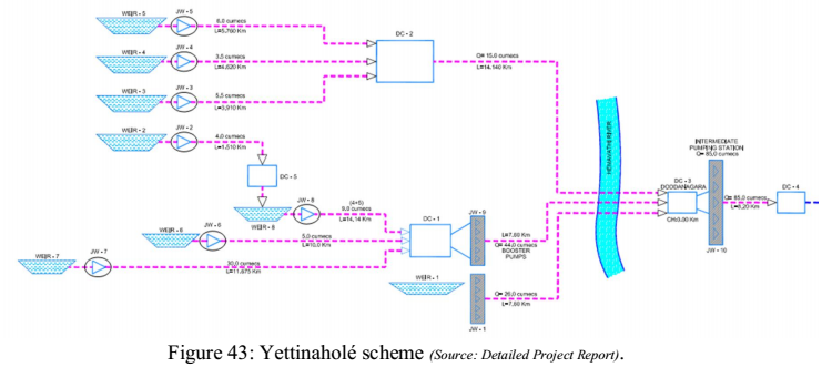
  • Diverting water from Weirs 3, 4 and 5 to Delivery Chamber (DC 2) beyond which, a gravity canal is proposed to carry water to the Delivery chamber (DC 3) located beyond Hemavathi River near Doddanagara.
  • The water from Weir 1 received from the independent catchment of Yettinaholé is pumped and conveyed through a raising main up to DC 3 near Doddanagara.
  • The water from Weir 2 is proposed to be conveyed to Weir 8 through a raising main and then by gravity. The water from Weirs 6, 7 and 8 will then be conveyed through pumping and independent raising mains up to the Jack well cum Pump house situated near Weir 1.
  • The two Jack well cum Pump houses near Weir 1 will then be used to pump the water received from Weirs 1, 6, 7 and 8 to DC-3 located near Doddanagara in Sakleshpura Taluk. From DC 3, the water will be pumped and conveyed to De livery chamber (DC-4) located near Haravanahalli in Sakleshpura taluk, the starting point of the gravity canal.

Phase 2 component comprises of the following

  • Construction of Gravity canal for a length of 273Km +865m including an aqueduct of 12.5 Km.to reach the proposed balancing reservoir at Bhairagondlu.
  • Construction of storage reservoirs identified in the beneficiary taluks.
  • Construction of balancing reservoir at Bhairagondlu in Koratagere taluk.
  • Construction of raising main of length 45 Km to convey the water for Kolar, Chickaballapura and Bangalore rural districts.
  • Construction of feeder canals to supply required quantum of water to the beneficiary areas through dedicated feeder canals / conveyance system.


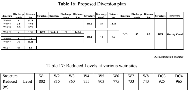
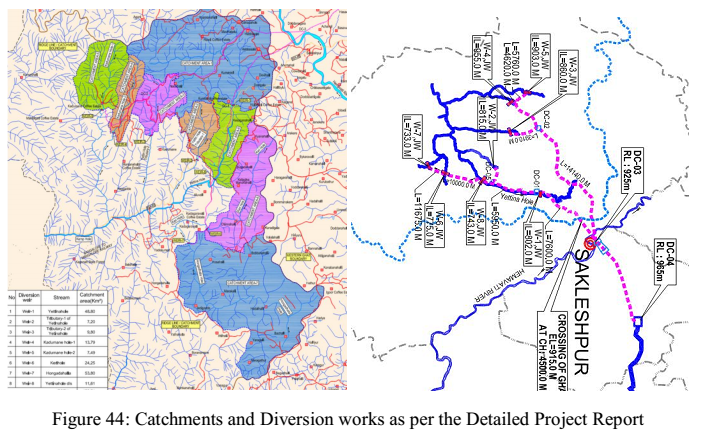
The scheme (given in Figure  43) proposes to install 8 weirs across various streams and locations namely the yettinaholé, hongadahalla, keriholé and kadumaneholé respectively. The water stored at the weirs whose height varies upto 15m from the ground level and further pumped into a common storage area(s) as depicted in Figure  43 and as in table 16. The location of the weirs, their catchments and the distribution chambers under the scheme are as depicted in Figure  34.


The water from the catchments stored at various up stream locations of the weirs and the distribution chambers is pumped to a common distribution chamber [DC4] from an RL of 733m AMSL [Weir 7] to 925 m AMLS [DC3], further 85cumec water is pumped to DC4 located at an RL of 965m near Haravanahalli and allowed to flow by gravity canals for about 274 km (table 17, Figure  44).


Private rain gauge stations and Kadumane estate were used in order to quantify the rainfall in the catchment (Pg 103), the catchment receives an average annual rainfall of 6280mm.The runoff yield in the catchment was estimated by taking the proportion of catchment area (since the streams belong to the same catchment) to that of based on the data available at the downstream gauging station maintained by the central water commission (CWC) across Netravati river at Bantwala. Daily flows between 1971 – 2008 between June and November were considered in order to estimate the yield in all the sub catchments of Bantwala (proposed 8 weirs and their catchments) as the diversion of flows after November would affect livelihood of the people downstream.
Weirs were proposed to be constructed across the streams selected to store water up to their banks and divert the water during the peak monsoon months from June to November, The combined quantum of water which can be diverted from the 8 Weirs is estimated to be about 24.01 TMC. On an average weirs are proposed to store water upto 5 Mcft (141 kilo.cum) to
The available 24.01 TMC of water is proposed to be utilized under two components namely drinking water and tank filling in the selected areas
Providing drinking water to:

  • Kolar district comprising of all Taluks
  • Chickaballapura distrct comprisnig of all Taluks
  • Tumkur district comprising of areas in Palar and Pennar basins  including  Chiknayakanahalli
  • and Sira Taluks along with selected villages in Tiptur and Gubbi Taluks.
  • Hassan district comprising of villages in Arasikere taluk
  • Chikamagalore district comprising of selected villages in Kadur taluk
  • Ramanagara district
  • Bangalore Rural district comprising of Nelamangala, Doddaballapura, Devanahalli and Hoskote Taluks
  • Augmenting the water to T.G.Halli reservoir
  • Augmenting water to Hesaraghatta reservoir
  • Drinking water supply to Devanahalli Industrial area and surrounding areas

Providing water for tank filling purposes to fill selected M I Tanks to their 50 % capacity in the M I tanks falling under Palar and Pennar basins and Arasikere taluk
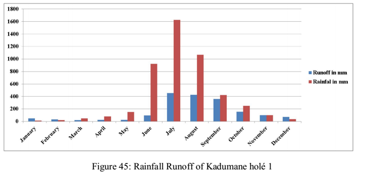
As per the Karnataka Power Corporation, specified yield of 24 TMC cannot be achieved based on monitoring the daily runoff at various places along the Netravathi river basin. As per the Annexure-2 of the DPR, Kadumane holé 1, daily gauged values between 2009 and 2012 were used in order to understand the yield in the catchment, and is listed in table 18 and the rainfall runoff curve is given  in Figure 45. Rainfall data is based on the110 year data from the rain gauge stations in and around the catchments obtained from department of statistics.
The runoff yield derived from the hydrological model was compared with the measured runoff (KPC), the derived (estimated) yield in the catchment is 0.702 TMC, whereas the measured was 0.813 TMC.

Table 18: Runoff Data KPC (Annexure 2-DPR)


Runoff in kilo.cum

Runoff in mm

Rainfall in mm

Month

2009

2010

2011

2012

Average

January

-

647.6

913.7

681.3

780.6

49

13.1

February

-

460.8

639.4

297.3

550.1

30

18.8

March

-

319.3

447.6

190.3

383.4

21

47.6

April

-

494.8

404.3

249.6

449.5

25

76.9

May

-

330.8

252.6

479

291.7

23

151.5

June

-

947.2

2424.9

1022.9

1686.1

95

920.4

July

14500.5

3135.6

5627.2

4654.7

7754.5

453

1625.5

August

4697.1

5564.2

7473.5

8537.1

5911.6

426

1065.7

September

4621.7

4761.3

6975.5

5883.9

5452.8

361

422

October

3080.8

2682.6

1864.3

1859.3

2542.6

154

251.4

November

1255.6

1872.2

1476.2

-

1534.7

100

98.8

December

1109

1383.3

759.9

-

1084.1

70

33.7

Annual Rainfall in TMC : 2.345

Annual Runoff in TMC : 0.813 (KPC), 0.702 (hydrological analysis)

  Accuracy of the Hydrological Model 86.1%

.       

E-mail     |     Sahyadri     |     ENVIS     |     GRASS     |     Energy     |     CES     |     CST     |     CiSTUP     |     IISc     |     E-mail