| ENVIS Technical Report: 90, April 2015 |
1Energy and Wetlands Research Group, Centre for Ecological Sciences,
2Centre for Sustainable Technologies (astra)
3 Centre for infrastructure, Sustainable Transportation and Urban Planning [CiSTUP],
Indian Institute of Science, Bangalore, Karnataka, 560 012, India
Web: http://ces.iisc.ac.in/energy
E Mail: cestvr@ces.iisc.ac.in; ganesh@ces.iisc.ac.in
Tel: 91-080-22933099, 2293 3503 extn 101, 107, 114
4Adamya Chetana, Annapoorna - Bangalore, Community Hall,
Kempegowda Nagar, Bengaluru, Karnataka 560019
Tel: 080 2662 0404, E Mail: tejaswini.acf@gmail.com
5
R K Mission, Shivanahalli, Anekal, Bangalore,
E Mail: vishnumayananda@gmail.com
*Corresponding author: cestvr@ces.iisc.ac.in
|
|
|
Watershed refers to a drainage basin or a catchment area of a water body. It is defined as ‘land area from which water drains to a common point’ (Tideman, 2000). A valley surrounded by two or more hill from which water drains; accumulates and runs off as a tributary to a large river (Figure 9). However, water run-off (overland flow) depends on the soil type and its structure, vegetation cover (land use) and also topography - slope. During the high run-off, top fertile soil gets removed and transported to the downstream and collected in valleys or lakes. Managing watershed would help in water and soil conservation as it reduces soil erosion while increasing the duration water availability and quantum of percolation. Watershed management approach considers the land use in the catchment area, precipitation and soil structure to meet the water requirement. Management includes adopting traditional practices like water harvesting (through tanks, percolation tanks), check dams, bundling, bench-terracing, afforestation with native species of grass and trees, etc. Greening watershed area with native species of grasses would also help in rejuvenating soil as it conserve water and soil.
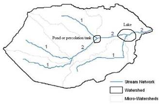
Figure 9: Typical watershed and stream network
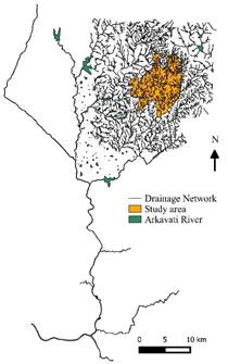
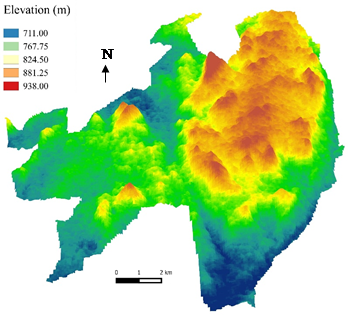
Ragihalli village panchayat is located at 700 m above mean seal level in a hilly region with undulating terrain, ranging from 711m to 938m in the region creating valleys and steep slopes (Figure 10 and 11). Erosion of top soil due to gush of water during precipitation rains is common in slopes due to fallow land without vegetation cover.
Planting grasses and native tree species mitigates soil erosion while helping water percolation and also produce value added products (fruits, medicine, etc.). Lakes and percolation tanks need to be constructed at valleys and stream intersecting points to optimise harvesting and percolation of water. Check dams and bunds shall be constructed across main streams with permanent structures to increase the water percolation, which also acts as silt trap.
 |
 
|
Figure 10: Stream network connecting Arkavati river |
Figure 11: Elevation in the village |
WATERSHED MANAGEMENT: GROUND WATER RECHARGE
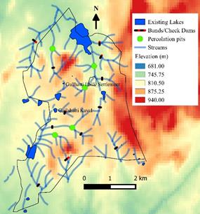
Watershed management essentially enhances ground water table by either through allowing infiltration of rain water through ecological (vegetation) or engineering (structures: check dams, percolation pits) interventions. Geo-spatial techniques aid in finding the appropriate sites for percolation tanks, bunds and check dams. 3D elevation model aids in visualising feasibility of these locations and also to demarcate watershed area. Figure 12 gives DEM of the region with stream network and water bodies and Figure 13 illustrates undulation in the region. Various possible interventions required to conserve soil and water in the region are:
- Structure construction
- Gully control
- Check dams and gully plugs
- Percolation tanks
- Contour bunding, Stone lines
- Vegetating land (at least 33% of the total land cover)
- Vegetative strips and fodder plantations;
- Turfing with native grasses;
- Planting of native tree species which enhance ecological services in the region (pollination, etc.)

|
|
Figure 12: Stream network and waterbodies |
Figure 13: 3D visualisation of elevation |
Gully control measures: Generally, gullies are formed due to increase in surface water run-off. Essentially gully control refers to reducing the water run-off which includes the following methods;
- Improving the catchment land use to reduce and regulate the run-off
- Diversion of surface water above gully area
- Stabilisation of gullies through structure and vegetation
The first and second method is generally used in moderately raining regions where as the 3rd method is adopted in high rain areas. The factors affecting gullies can be broadly classified into 2 categories, which are shown in Table 4.
Table 4: Factors affecting gullies
Man-made factors |
Physical factors |
Land use |
Precipitation |
Forest and grass fires |
Topography |
Overgrazing |
Soil properties |
Mining |
Vegetation cover |
Road construction |
|
Livestock and vehicle trails |
|
Destructive logging |
|
Gully control is one of the most important restoration methods in watershed management, where timing is an essential element. The field work in all structural and vegetative control measures selected should be completed during the dry and early rainy season. Otherwise, the incomplete structural work can easily be destroyed during the first rainy season. In addition, vegetative measures such as the planting of tree seedlings and shrub and grass cuttings cannot begin until structural work is complete. Each continuous gully in a gully system should be regarded as a basic treatment unit, and all the control measures in that unit should be finished before the rainy season.
For a continuous gully, criteria for selecting structural control measures are based on the size of the gully catchment area, gradient and the length of the gully channel. The various portions of the main gully channel and branch gullies are stabilized by brush fills, earth plugs, brushwood, loose-stone check dams. The lower parts are treated with loose-stone or boulder check dams. At a stable point in the lowest section of the main gully channel, a gabion check dam or cement masonry check dam should be constructed. If there is no stable point, a counter-dam (gabion or cement masonry) must be constructed in front of the first check dam.
Check Dams and Gully Plugs: A check dam (also called gully plug) is a small, temporary or permanent dam constructed across a drainage ditch or channel to reduce the speed of concentrated flow or run-off. A check dam can be built from wood logs, stone, pea gravel-filled sandbags or bricks and cement. Controlled runoff speed reduces soil and gully erosion in the channel and allows settling of sediments and other pollutants. Check dams are inexpensive and easy to install. They may be permanent if designed properly and can be used for 4 to 5 years. Further, they allow groundwater recharge and are able to retain soil moisture while aiding as silt trap.
The size and shape of a drainage area, with the length and gradient of its slopes, effect the run-off rate and amount of surface water. Gully plug or check dam design need complete details of topographic characteristics of the region. Construction of check dams shall consider following aspects;
- The sides of the check dam must be higher than the centre so that water is always directed over the centre of the dam (this avoids the dam being eroded by the flow).
- The dam can be made of temporary or permanent materials in natural gullies on the land surface. Materials used are concrete, earth, vegetation, stone and brushwood.
- Do not construct check dams in watercourses or permanently flowing streams without specific design (because of possible restrictions to fish passage).
Percolation Tanks: Percolation tanks are the engineered structures for recharging ground water. These are generally constructed across streams or stream joining locations and bigger gullies in order to impound a part of the run-off water. Pond is constructed by excavating a depression, forming a small reservoir or by constructing an embankment in a natural ravine or gully to form a reservoir. The stored water in these tanks, in due course, finds its way into subsoil and recharges the ground water. This leads to better recuperation of wells in the downstream areas. Such ponds have become popular in many a place where the annual rainfall is lower.
The construction of percolation tanks can be undertaken when the agriculture community is free of farm work and during non-monsoon season. Small structures can be completed within 2-3 months while a large one takes about 7-9 months. The following factor may be considered during the construction of percolation tanks;
- It should not be located in heavy soils or soils with impervious strata,
- The top soil needs to be porous.
- Suitable and adequate soil for forming embankments.
- The ideal location of the pond will be on a narrow stream with high ground on either side of the stream.
- Simple, economic and efficient extension should be possible.
Farmers (stakeholders) participation is vital in the construction and management of ponds. Linkages among farmers and various organisations would help in this endeavour.
Water and Soil Conservation
Contour Bunding: It is a traditional low cost method of soil conservation and run off reduction technique suitable for low slope areas. It is proven sustainable technique in hilly land where the soil productivity is very low. Over many generations, this technique has been successfully used to control soil erosion, promote water retention while increasing crop yield. It can be replicated in most of the agricultural fields since it is simple to implement, less expensive and makes the maximum use of local resources.
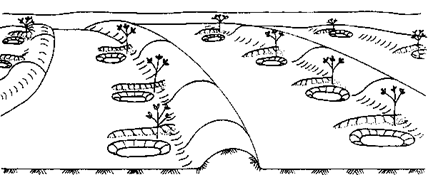
Figure 14: Contour bunds for trees
Contour bunds are a simplified form of micro-catchments which stops the run-off water and allows it to percolate. Here the bunds follow the contour, at close spacing. This technique is suitable for cultivation crops or fodder between the bunds. Semi-circular bunds can also be designed for low slope areas with even terrains.
Fodder production through Vegetative Strips: A vegetative strip of grass, shrubs or trees planted across the slope. It slows down water flowing down the slope, and traps sediment that has been eroded uphill. Over time, soil may build up behind the strip, forming a terrace. Vegetative strips are economical and easy to establish. Once they are growing, it is easy to maintain, and provide valuable fodder for animals.
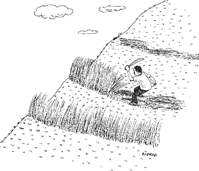
Figure 15: Vegetative strips
Conventional agriculture can be practiced in the land between the strips and the fodder can be harvested regularly. Fodder grass options for vegetative strips are;
- Napier grass (Elephant grass) have been tried as a fodder for cattle. The growth has to be regulated which otherwise cover entire area.
-
Makarikari grass (Panicum coloratum mararikariense) is drought resistant and can be fed to livestock in the dry season.
- Cash crops such as pumpkins and melons may also be grown in vegetative strips.
- Other option is to allow natural vegetation to grow in the strips. In that case, measure should be taken to control weeds in these strips.
Stone Lines: Stone lines are commonly used in both dry and humid areas which are constructed wherever loose stones are available. These structures slow down the runoff and gradually soil builds up behind them.

Figure 16: Stone lines and planting pits
The distance between the lines depends on the slope and availability of stones in the area. Typically, on 2–5% slopes, stone lines are about 25–50 m apart. Planting pits are often used in combination with stone lines. Which is a traditional form of conservation agriculture.
Tree shrubs for soil erosion control: The tree and shrub species listed below are commonly used in gully and erosion control. This list gives the general idea about gully re-vegetation through native tree and shrub species. Fodder grass can also be cultivated in low slope regions with fruit bearing trees which is more suitable for the region.
Village wise structure construction for watershed management
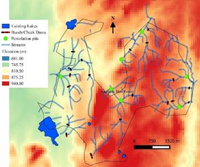
Figure 17 illustrates the structures such as check dams, gully controls and percolation tanks construction location for all villages in the panchayat. It also gives the stream network and elevation of the region. These structures are to be implemented without affecting the agriculture and public amenities.
- De-silting of existing water bodies (to enhance water storage capacity as well as to improve groundwater recharge).
- Planting riparian vegetation of native species in the buffer zone of water bodies (buffer zone of 200 m)
- Planting of native grasses in fallow land and in slope region (undulating terrain) on priority, would help in improving ecology and also water infiltration capability
- Fodder crops during lean season would improve the fodder availability vital for livestock management
- Native tree and grass species be planted in barren areas and also on the banks of percolation pits.
- Permanent gully controls or check dams to be constructed across the streams and grass turfing along slopes (Table 5).
Table 5: Multi-purpose vegetating option for soil and water conservation
Trees |
Benefits |
Leucaena leucocephala (Subabul) |
Legume provides high-protein cattle fodder. Fast growing, higher biomass yield and fixes nitrogen. |
Azadirachta indica (Neem) |
Evergreen tree with high medicinal properties. High market value for products from oil. |
Pongamia pinnata (Honge Tree) |
Oil is used in bio-diesel production and can be used in diesel irrigation pumps. |
Gmelina arborea (White teak) |
Timber is used for construction and furniture. Bark and root has medicinal value. |
Dalbergia sissoo (Indian Rosewood) |
Evergreen tree with high energy value and used as timber. |
Acrocarpus fraxinifolius |
Used in construction, making of packaging boxes, furniture etc. The foliage is used as fodder and the flowers are a source of nectar for honey bees. |
Tamarindus indica |
Long life and tamarind has high market value. Fuelwood can be harvested. |
Grass |
Pennisetum purpureum (Napier grass or Elephant grass) |
Higher productivity and generally grown in all region. |
Cenchrus ciliaris (Anjan grass) |
It’s a perineal grass which also reduces soil erosion. |
Dichanthium annulatum (Karad grass) |
It is a perineal grass and can be used for field grazing. Cattle find it palatable. |
Macrotyloma uniflorum (Horse gram) |
Seeds of horse gram are generally utilised as cattle feed. It also famous for its medicinal properties. |
Cymbopogon citratus (Lemon grass) |
Used as herb and also conserves top soil. Has good market value |
Chrysopogon zizanioides (Lavancha Grass) |
Helpful in soil erosion mitigation. Roots are used in crafts and also used as herb. Has high market value. |

Shivanahalli
|

Ragihalli
|
Gullattihalli
|

Gottigehalli and Sonneri doddi
|
Bannerghatta National Park
|

Billiganakuppe
|
Figure 17: Village wise watershed management plan
|
Dr. T.V. Ramachandra
Centre for Sustainable Technologies, Centre for infrastructure, Sustainable Transportation and Urban Planning (CiSTUP), Energy & Wetlands Research Group, Centre for Ecological Sciences, Indian Institute of Science, Bangalore – 560 012, INDIA.
E-mail : cestvr@ces.iisc.ac.in
Tel: 91-080-22933099/23600985,
Fax: 91-080-23601428/23600085
Web: http://ces.iisc.ac.in/energy
Ganesh HegdeEnergy & Wetlands Research Group, Centre for Ecological Sciences, Indian Institute of Science, Bangalore – 560 012, INDIA.
E-mail: ganesh@ces.iisc.ac.in
Subhash Chandran M.D.Energy & Wetlands Research Group, Centre for Ecological Sciences, Indian Institute of Science, Bangalore – 560 012, INDIA.
E-mail: mds@ces.iisc.ac.in
Tejaswini Ananth KumarAdamya Chetana, Annapoorna - Bangalore, Community Hall,
Kempegowda Nagar, Bengaluru, Karnataka 560019
E-mail: tejaswini.acf@gmail.com
Vishnumayananda SwamijiR K Mission, Shivanahalli, Anekal, Bangalore
E-mail: vishnumayananda@gmail.com
Citation:Ramachandra T V, Ganesh Hegde, Subash Chandran M D, Tejaswini Ananth Kumar and Vishnumayananda Swamiji, 2015., SMART Ragihalli: Effort towards Self-reliant & Self-sufficient system empowering Man power (rural youth) with Appropriate Rural Technologies,ETR 90, Energy & Wetlands Research Group, CES, Indian Institute of Science , Bangalore
| Contact Address : |
| |
Dr. T.V. Ramachandra
Energy & Wetlands Research Group,
Centre for Ecological Sciences, TE 15, New Biology Building, Third Floor, E Wing, [Near D Gate], Indian Institute of Science, Bangalore – 560 012, INDIA.
Tel : 91-80-22933099 / 22933503-extn 107
Fax : 91-80-23601428 / 23600085 / 23600683 [CES-TVR]
E-mail : cestvr@ces.iisc.ac.in, energy@ces.iisc.ac.in,
Web : http://wgbis.ces.iisc.ac.in/energy |
| |