Freshwater river systems are among the most diverse and productive ecosystems in the world. Much of the biodiversity associated with the riverine landscapes is attributable to heterogeneity at the habitat scale. From a holistic landscape perspective, riverine habitats comprise running and standing waters, permanent and temporary waters, wetlands and groundwater (Ward, 1998). At the same time, the biodiversity of most microbial, plant, and animal groups of stream, lake, and wetland ecosystems is very poorly known (Wetzel, 2001).
Human evolution exhibited repeated speciations from Australopithecus to Homo habilis, H. erectus, and H. sapiens; and from their hominoid ancestor to orangutans, gorillas, chimpanzees, and humans (Ayala and Ananias, 1996) and this event spanned approximately 4 million years. This emergence from a position of a social ape of the savannas to its present position of global dominance has been a key in the changes that already took place and those still happening world over. Such changes are the clever manipulation of the environment, deflecting energy from other parts of the natural food webs into the support of one species (Cox and Moore, 2000). Part of the success of the human species has been their ability to influence the hydrological cycle: storing water for drinking, growing food and driving industrial processes and harnessing its power to generate power and fight against natural hazards, such as floods and droughts (Acreman, 2001). Our overall activities and their side effects have shaped the natural resource base as human-modified ecosystems.
Human interaction with the physical environment has increasingly transformed Earth-system processes (Dillehay and Kolata, 2004). Wherever human land use is located near sensitive natural areas, such as wetlands, it had significant impacts on biodiversity in such areas (Eppink et. al 2004). These ecosystems share a common set of traits including simplified food webs, landscape homogenization, and high nutrient and energy inputs. Ecosystem simplification is the ecological hallmark of humanity and the reason for our evolutionary success. However, the side effects of our profligacy and poor resource practice are now so pervasive as to threaten our future no less than that of biological diversity itself (Western, 2001). The magnitude of the resulting change is so large and so strongly linked to ecosystem processes and society’s use of natural resources that biodiversity change is now considered an important global change in its own right (Sala, et. al 2000). At present, species are going extinct at a rate 100 times the natural background rates (Pimm and Lawton, 1998).
Beginning of the human civilization is believed to on the banks of world’s major rivers. Due to this, river basins are renowned as the cradles of civilization and cultural heritage. Ancient and modern communities alike have depended on rivers for livelihood, commerce, habitat and the sustaining ecological functions they provide. Throughout the history alterations to rivers – have affected riverine communities in one-way or other (WCED 2000). Human pressures have now reached a state where the continental aquatic systems can no longer be considered as being controlled by only Earth system processes, thus defining a new era, the Anthropocene (Maybeck 2003).
Riverine ecosystems are critical components of the global environment. In addition to being essential contributors to biodiversity and ecological productivity, they also provide a variety of services for human beings, including water for drinking and irrigation, recreational opportunities, and habitat for economically important fishes. However, aquatic systems have been increasingly threatened, directly and/or indirectly, by human induced activities. Aquatic ecosystems, in addition to the challenges posed by land-use change, environmental pollution, and water diversion, are expected to experience the added stress of global climate change.
Available information suggests that over the past 30 years, freshwater biodiversity has declined much faster than either terrestrial or marine biodiversity. The ever-increasing demands placed on freshwater resources in most parts of the world has led to the uneven and continued loss of biodiversity. Pollution, siltation, canalization, water abstraction, dam construction, over-fishing, and introduced species will all play a part, although their individual impacts will vary regionally. The greatest effects will be on biodiversity in fresh waters in highly diverse and densely populated parts of the tropics, particularly South and Southeast Asia, and in dry-land areas, although large-scale hydro-engineering projects proposed elsewhere could also had catastrophic impacts (Jenkins 2003).
River ecosystems of India
The Indian sub-continent is traversed by a large number of rivers, which played a major role in shaping the history of human civilization in the sub-continent. It has very rightly been said that River Ganga has been the cradle of civilization in the Indian sub-continent. The rivers have been extensively used for various purposes, including irrigation, drinking water, recreation, fishing, transport, etc (Venkataraman, 2003). There is a dense network of rivers all over India, constituting the most important water resources for the country. The river systems are grouped on the basis of their drainage - basin area into major (more than 20,000 km2), medium (2000 – 20,000 km2) and minor (<200 km2) rivers. Accordingly, 15 major, 45 medium and 120 minor systems, besides numerous ephemeral streams in the western arid region drain the mainland. The rivers of the Indian mainland can be grouped according to their origin, into Himalayan and peninsular rivers (Sinha and Sinha 2003).
Human population in India has reached 102.8 crores in 2001, which was 84.6 crores in 1991 with 21.3% increase (Census of India, 2001). Major portion of the water requirement of this population is met from the rivers. Consequently, human impacts on rivers throughout the country extend well beyond direct use of water to all activities in the floodplain and the entire catchment. Uncontrolled discharge of untreated (or partly treated) muncipal sewage and industrial effluents has reduced many river stretches into wastewater drains (Gopal, 2000). Now India is determined to go ahead with its single-point agenda of economic growth, the proposal to link major rivers for combating local water deficits. Over the next 10 years, it is envisaged that 37 major rivers in India will be linked through 12,500 km of canals and requiring the construction of at least 400 reservoirs (Daniels, 2004).
Western Ghats’ scenario
Western Ghats that lies in the western part of peninsular India is a series of hills stretching over a distance of 1,600 km from north to south and covering an area of about 1,60,000 Sq. km. Western Ghats’ extraordinary biological heritage makes the region one of the highest priorities for international conservation efforts and is recognized as one of the 25-biodiversity hotspots of the world (Myers et al., 2000). These Ghats are known for exceptional species richness and endemism in angiospers, amphibians, reptiles and freshwater fishes. About 38-east flowing and 37 west flowing river systems of the region inhabit over 288 species of freshwater fishes of which about 118 are endemic to the region (Dahanukar et al., 2004).
Major threats acting upon the freshwater ecosystems of the Western Ghats are deforestation, impoundments, and water diversion. Many people depend on the water in the Western Ghats Rivers and Streams for agriculture. Steep and undulating terrain of the region has provided the optimum differential head required for the hydroelectric power generation. Because of these, several development projects have diverted water for irrigation, which dries up streams and brooks. Dams built on the rivers have changed the natural flow of water and destroyed habitats.
(http://www.worldwildlife.org/wildworld/profiles/g200/g171.html#intro).
However, there is relatively small amount of published information in scientific journals that is available for river conservation in Western Ghats. The bulk of the literature is unpublished grey literature. Published information on freshwater biota of the Western Ghats is largely of a taxonomic nature and is sporadic throughout the systematic literature. However, in many regions, basic taxonomic information for most groups of organisms is lacking. Among the many westflowing rivers of the Western Ghats, a few of them have been extensively harnessed for hydro-electric powers, irrigation, and fisheries. Sharavathi River, one of the earliest exploited rivers amidst Western Ghats, and its ecosystem status are discussed in this report.
Sharavath River – Environmental setting
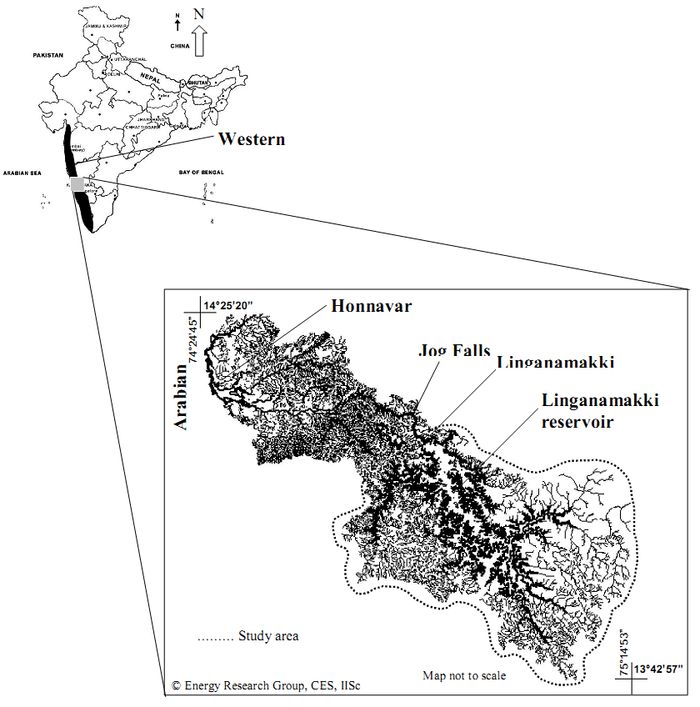
Sharavathi River is one of the west flowing rivers of Karnataka. The river basin comes under the two districts namely Shimoga and Karwar (called Uttara Kannada till recently). Two taluks in Shimoga district (viz., Sagar, Hosanagara) and three taluks in Karwar district (viz., Honnavar, Kumta, Siddapur) constitute the study area of the basin. The river rises at Ambuthirtha near Kavaledurga in Thirthahalli and flows in a northwesterly direction and receives Haridravathi river on the right (below Patterguppe) and Yenneholé on the left above Bharangi. Of a due course of 131 km in journey, the river receives a series if small tributaries like Nagodi, Kalkatte hole, Mavinahole, Hadinabal, Bhaskeri, Gudankatte hole, etc. Near the border of the Shimoga district, it bends to the west and hurls down near Jog from 255 m height. This river has a catchment area of approximately 2,784 sq. km. The river confluences the Arabian Sea at Honnavar in Uttara Kannada district (Figure 1).
Figure 1. Drainage network and study area of River Sharavathi.
Ecological Significance of Sharavathi River Basin
The Sharavathi River in the Central Western Ghats, Karnataka is recognized as a hot speck in the biodiversity hotspot. Sharavathi Valley forms the northern limit of many endangered ecosystems, flora and fauna such as Myristica Swamps, Gymnacranthera canarica and Lion-tailed Macaque (Macaca silenus). These features illustrate the ecological significance, and the conservation importance of the region. The river basin has a vegetation cover that ranges from evergreen to semi-evergreen forest along with moist deciduous type of forests. Along with this, scrub savanna, grasslands, marshy areas and plantations are the major land covers of the region. Rare evergreen and endemic species belonging to the genera Dipterocarpus, Calophyllum, Lophopetalum, Myristica, Gymnacranthera, Syzygium, Diospyros, Aglaia, Poeciloneuron, Palaquium, etc. and Semicarpus kathalekanensis, a rare and endemic tree species that is restricted to Kathalekan of this river basin make Sharavathi river basin an ecologically sensitive region. Presence of around 140 islands in the reservoirs of Sharavathi wherein almost all islands covered with semievergreen to moist deciduous forests represents the fragile ecosystem. Mammals like Gaur, Sambhar, Spotted deer, Boars, Pangolins and Porcupines are also present. The upper catchment of the study area is a habitat for endangered Grey headed Bulbul, Great Indian Hornbill, and endemic species as Black necked stork, White Ibis, Blue bearded Bee-eater, Great Black Woodpecker and Slatyheaded Scimitar babbler (http://wgbis.ces.iisc.ac.in/energy/sharavathi/svati.htm). Sharavathi River is the dwelling place for a rare freshwater fish, Batasio sharavatiensis, a species reported from this river and yet the distribution is limited to this river.
Developmental Activities in Sharavathi River Basin
Sharavathi River has witnessed a series of alterations during the last century.Construction of Madenur (Hirebhaskar) dam across this river in 1932 is the first large-scale alteration in the river basin. Subsequently, another dam constructed near Linganamakki in 1964 is one of the oldest hydroelectric power projects in. Several small-scale reservoirs like Talakalale, balancing reservoirs for Mahathma Gandhi hydro-electric power generation were also commissioned soon after the completion of Lingnamakki Dam. In total, there are three major reservoirs in the Sharavathi river basin, Linganamakki, Talakalale and Gerusoppa. Gerusoppa, also known as Sharavathi Tail Race Project is the latest hydro-electric power project established on the Sharavathi river in 2001. To cope up the water requirement of huge power generation plant of Linganamakki dam, River Chakra, an adjacent river was diverted and connected to Sharavathi River through manmade canals. For the river Chakra, two dams were constructed at Chakra and Savehaklu. Madenur dam has submerged an area of about 27.52 km2, where as Talakalale about 7.77 km2 and Gerusoppa reservoir submerged 7.11 km2 The Linganamakki reservoir has submerged about 326.34 sq. km. of prime forest area rich in biodiversity. Similar to most of the river valley projects in India, these projects in Sharavathi river basin were also evolved considering only the developmental aspects . Thus, these developmental activities have resulted population influx into the river basin especially in western hilly region of fragile forests and perennial streams, consequent on spurt of other developmental activities such as agriculture, increase in built up areas, etc. In this connection present study has been carried out in the catchment area of Sharavathi River to understand the cumulative effects of the changes on the aquatic ecosystem of the river basin.
Objectives: Objectives of the current investigations are:
- Assess the status of water and sediment by physico-chemical and biological characterization.
- Phytoplankton studies for species composition and their differences between the stations of reservoir and streams, population and bloom of phytoplankton, species diversity, richness, and dominance and to assess the trophic status of the river basin using phytoplankton group, genera and species
- Zooplankton studies to acquire the information on their diversity and distribution over the river basin.
- Freshwater fishes dealing with ichthyo-diversity and the existing pattern of commercial fishery.
- Explore suitable watershed management and conservation strategies for their long-term sustenance.
