UTTARA KANNADA ESTUARIES
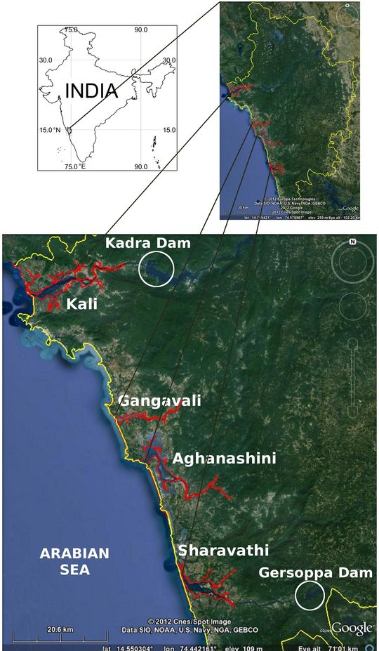
The Uttara Kannada District has four major estuaries viz. Kali, Gangavali, Aghanashini, and Sharavathi (Figure 1.1). The Kali estuary is located in the northern most part of the district, the Bedthi or Gangavali about 32 km south from Kali river-mouth, the Aghanashini or Tadri estuary, about 10 km south of Gangavali, and the Sharavathi estuary is about 24 km south of the Aghanashini estuarine mouth.

Figure 1.1: Estuaries of Uttara Kannada District viz. Kali, Gangavali, Aghanashini, and Sharavathi.
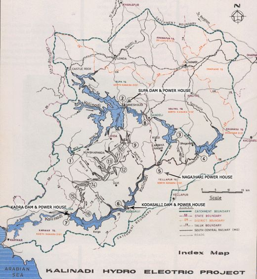
Kali Estuary: The Kalinadi originates near the village Diggi in the Joida taluk of Uttara Kannada, and has many tributaries. It is also known as Karihole and as Dagi in its upper reaches. Its total length is 184 km and meets the sea, three km north of Karwar. It has four major dams with hydel power stations viz. Supa, Nagjhari power house, Kodashalli, and Kadra (Figure 1.2).

Figure 1.2: Kali River with Dams.
Source: www.karnatakapower.com [accessed on 10 February 2012]
Gangavali Estuary: The river Bedthi or Gangavali originates at two places; one is near Someswara temple, south of Dharwad and another is near Hubli, both join near Kalghatgi. The total length of the river is 161 km, and it has no dam or hydel power station. It joins the Arabian Sea at Gangavali near Ankola. The estuarine part starts near the village Gundbale (about 15 km interior) and the area of the estuary is 640 ha (Gazetteer 1984; Rao et al. 1989).
Aghanashini Estuary: The Aghanashini or Tadri (total length 121 km) river rises at Manjguni near Sirsi. It has two sources, the Bakurhole rising in a pond at Manjguni about 25 km west of Sirsi and the Donihalla whose source is close to Sirsi. These streams meet near Mutthalli about 16 km south of Sirsi. At Uppinapattana the river meets the tide and it winds south-west and then north-west together about 13 km to Mirjan. From Mirjan it runs parallel to the coast for about 13 km and meets the Arabian Sea at Aghanashini or Tadri. This river has no dam or hydel power station in it (Gazetteer, 1984).
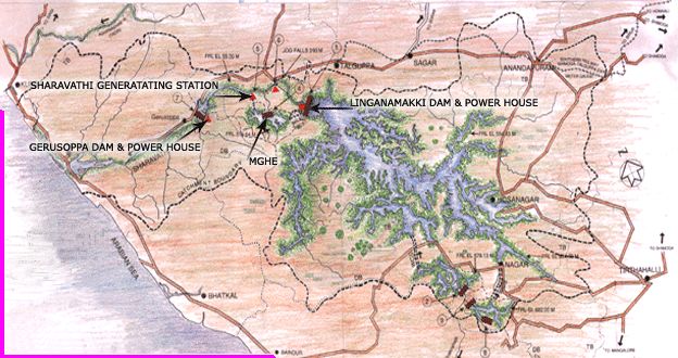
Sharavathi Estuary: Sharavathi originates at Ambutirtha in Tirthahalli taluk of Shimoga district and flows for 128 km to join the Arabian Sea near Honavar. Traditionally the estuarine portion extended from the river mouth to the village of Gersoppa, about 27 km interior, towards the base of the Western Ghats. The total area of the estuarine portion was stated to be 1600 ha (Gazetteer, 1984; Rao et al., 1989). This river has two major dams with hydel power stations, first one built at Linganamakki in Shimoga district and the second dam at Gersoppa (www.karnatakapower.com). These dams have caused substantial changes in the estuarine characteristics, primarily by reducing its salinity (Figure 1.3).

Figure 1.3: Sharavathi River with dams
Source: www.karnatakapower.com [accessed on 10 February 2012]