Chapter-1: BIO-SHIELDING OF THE COAST: AN INTRODUCTION
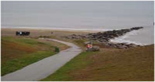
Sea shores the world over are characterized by deposits of sand or sand dunes wherever they are not bordered by rocky hills. The word ‘beach’ is used by most people to the sandy area that separates the sea from the land. The beach begins in the sand dunes above the high tide mark, the farthest point where the sand has been carried by wave action. It extends to the depth beyond which the wave action does not have sufficient force to move the sand particles. Beaches and sand dunes represent flexible barriers which absorb wave energy during storms by moving and adjusting their shapes and position. Sand dunes, however, cannot be viewed in isolation from other components of the coastal ecosystem. Sand dunes and beaches are interdependent that they have to be managed together. Sand dune management should be viewed within the overall context of integrated coastal area management (UNEP, 1998).From the point where the sand dunes are stabilized to a certain extent, the backshore region of the beach starts and extends down to a sudden change in slope, known as the beach scrap (Figure 1.1). The backshore generally contains one or more horizontal portions called berms. From the scrap the beach slopes seawards and is known as the foreshore. The foreshore extends from the high water to the low water line, and may have continuous slope or a low tide terrace. Beyond the low tide level is the offshore (Figure 1.2), which is submerged (Mukherjee, 1996).
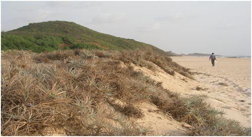
Fig. 1.1: Stabilized beach backshore showing sudden change in slope, the beach scrap
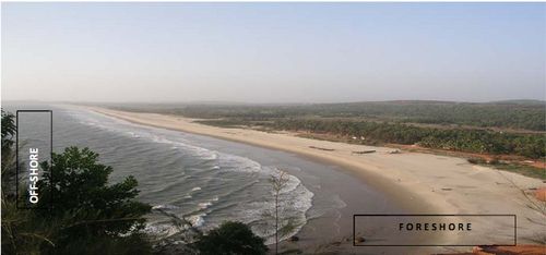
Fig. 1.2: Backshore (with new mud road), foreshore (the inter-tidal region), from white sands to offshore, the permanently submerged part
The U.S. Environmental Protection Agency (1998) defines a beach as “the area of unconsolidated material, such as sand, pebbles, or rocks, that extends landward from the low water line to the place where there is marked change in material or physiographic form, or to the line of permanent vegetation (usually the effective limit of storm waves).”In other words, a beach is the sandy, pebbly or rocky shore of a body of water. The water body may be even a lake or estuary. Rocky coasts are very stable unlike the sandy one (Figure 1.3).
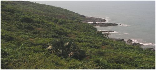
Fig. 1.3: Rocky coast of Apsarakonda, Honavar Forest Division
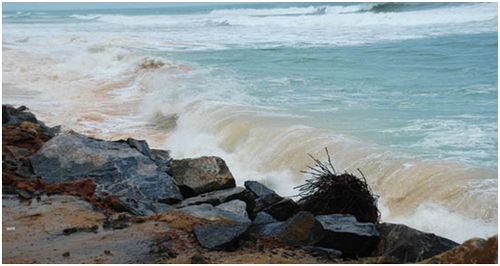
Erosion and accretion: Coastal erosion refers to the landward displacement of the shoreline caused by the forces of waves and currents. The sea can take away any unprotected shoreline especially the sandy beaches, if they are not supported behind by hilly terrain or if their vegetation is insufficient. Sandy beaches are dynamic sedimentary systems that naturally experience phases of erosion and accretion that operate over a range of time intervals. Frequent short term changes are seasonal erosion that mostly occurs in seasons when storms that generate erosional regimes are more frequent. Rapid erosion may also occur by high magnitude storms such as cyclones or low pressure systems. Accretion (deposit) of sand on beaches occurs during the more quite seasons when average swell waves deliver sediment back to the shoreline. Beach accretion is generally a much slower process than beach erosion. It may take several years for a beach to return to its original state after one major storm (Bhat, 2004).
Hegde, et al., (2009) have described erosion-accretion processes associated with the beaches towards the north and south of Sharavathi River in Honavar. Erosion takes place twice during the year, one during late May to early September (monsoon) and a minor phase during December to February. They also experience two periods of accretion, one during September to December (post-monsoon) and another during February to April. Northerly drift prevailing during the post-monsoon season favors spit growth across the river mouth from south to north, whereas the southerly drift during December to February is responsible for erosion of the portion of the beach to the north of the river mouth. The growth of a spit is at the expense of the beach to the north of the river mouth. Similar processes related to spit growth northward across the river mouths and retreat or narrowing of beaches to the immediate north of the river mouths were also observed towards the mouths of the rivers Venktapur and Gangavali in Honavar Forest Division. These processes cause narrowing of river mouths, spit growth across river mouths northwards, northward shift of river mouths as well as significant erosion of beaches to the north of these rivers (Nayak et al., 2006).
Causes of coastal erosion: Coastal erosiontakes place due to the landward displacement of the shoreline caused by the forces of waves and currents. Due to its effect part of the shore gets invaded by the sea permanently or temporarily. Wave action carries away sand into the depth the ocean, or re-deposits the sand on another beach. Taking place through long time such loss of shoreline can be an irreparable loss. The factors that influence the coastal erosion are both natural and manmade.
Natural causes
- Waves, currents and tides: The sea never is calm most of the time. Winds passing over waters offshore or near-shore generate waves. Waters rise to varied heights as waves on absorbing energy from the winds. The waves, roll shore-wards, break on the shore releasing the turbulent energy that they gained from the winds. The wave energy is a function of the wave heights and wave periods. We often witness that obstructions with hard surfaces on the way of the waves, such as rocky shores or seawalls, or breakwaters resist the waves. Therefore when winds are strong waves rise high and move faster shorwards, dash on the hard surface and release the energy in splashes and sprays. On the other hand the porous sands of the beaches, on the way of the waves, provide a cushioning effect, absorb most of this violent energy so that the waves roll gently over the beach. The attraction of the moon and the sun elevates the water level that gradually raises the sea level from about one meter on some shores to several meters on some others depending on the geo-morphology and ocean characters.The movement of tides as well as rising and receding waves creates various kinds of water current systems that shift sediments on to the land as well as away from the land.
- Winds, storms and cyclones::Winds not only create waves but also shift dry sand from place to place on the sea beaches and in lands beyond. In sea beaches with scanty vegetation winds can be important causes of erosion. Storms and cyclones are high intensity winds, which when pass over the ocean contribute substantial energy to the surface water, which rise considerably and pound violently on the land for hours causing much erosion and irreparable damages along the shoreline.
- Tsunamis: These are unpredictable events caused by underwater earthquake, creating gigantic tidal waves, which while inflicting enormous loss of life and property may also permanently alter coastline morphology. The deadly Indian Ocean tsunami of December 2004 is still green in our memory.
- Sea level rise: The geological ages have witnessed the rise and fall of the sea levels several times. Since the last ice age sea level has risen by 110 meters. Today, due to global warming caused by increased input of greenhouse gases there has been a gradual rise in the sea level. Every millimeter of rise in the sea level can cause the sea swallowing about half meter of land.
Human impacts: Constructions close to the shore, sea walls, breakwaters, sand mining building of dams upstream in the rivers which affect normal flow of water and deposit of silt towards the confluence, as well as destruction of shore vegetation are notable human impacts that result in coastal erosion.Seawalls destroy eroding beaches first by reducing the size of the beach. As water moves in it eventually meets the wall, flooding the beach. The wave action causes the underlying sand to erode quickly, undermining the wall. Everything in front of the seawall gets eroded away and the waves start pounding on the wall itself destabilizing it. The pressure of water increases on adjoining beaches following construction of sea walls. Shoreline erosion in the northern regions of Chennai, Ennore, Visakhapatnam and Paradip ports has resulted due to constructionof breakwaters of the respective port (Kumar et al., 2006). Mining of beach sands or tampering with the sand dunes in other ways, can lower the level of beaches and invite sea erosion.Dunes can be destroyed in places of unregulated tourism and where tourist resorts multiply. In beaches where wave energy is high it will be difficult to protect the coastline through dune formation. Coastal zones are variable and there is no simple solution to all coasts
Formation of dunes and dune fields:
- Sand dunes are narrow but important areas of sand that lie between the sea and the land. Dune-fields are formed above the beach as dry sand blows inland. The dunes may even extend several kilometers inland. Dunes form when there is an adequate sand supply and onshore winds of sufficient velocity to move the sand. As the dune builds, it becomes a major obstacle to the landward movement of windblown sand. Thus, the dune serves to conserve sand in close proximity to the beach system. When the wind encounters an obstacle its speed is reduced and the sand grains fall out under gravity, resulting in sand deposition. Sand will pile up on each side of an object resulting in a ridge parallel to the wind direction and streamlined by the wind. This type of dune is called the shadow dune. Eventually the object is likely to be buried again creating a smooth surface.
Plants are good objects that cannot be easily buried by the moving sands. They try to come above the sand surface, compared to a lifeless object. Vegetation can grow above the sand surface. Many plants cannot survive the harsh environment of the sea shore.
Wind flow over a sandy surface can increase friction with the sand and therefore the wind speed will decrease closer to the surface. Wind transports sand in three different ways: Saltation, suspension and surface creep. About 75% of sand is moved by saltation. It is the process of sand grains being flicked up by the wind and carried forward a certain distance, before depositing on the surface. A minimum wind speed of 5 m/second is required to lift the sand grains and a minimum of 4.5 m/s required for keeping the grains suspended in the air, otherwise the sand grains drop down forming heaps.Finer particles suspended in the air cannot drop easily and are not significant in forming dunes. Winds also push the sand and make it creep on the beach surface. With increased vegetation the beach surface becomes rougher. Normally on a smooth beach the zone of zero wind speed is 0.002 to 1 cm in height. Dense vegetation can increase this height to 18 cm (Pethic, 1984)
-
Embryonic dunes or fore-dunes: Individual plants or obstacles on the beach can act as centres for formation of dune embryos (Figure 1.4 & Figure 1.5). As the dunes grow the plants grow taller to peep above the dune surface. These unconnected mounds of sand can reach one to two meters in height depending on the heights the species of plants can reach. Once the dunes have grown in height the other creeping plants such as Spinifex, Ipomoea can take over. These form a complete protective cover over the surface.
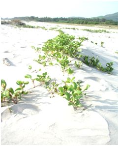
Fig. 1.4 : Ipomoea pes-caprae
|
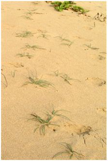
Fig. 1.5 : Cyperusmaritima colonizing the fore-dunes
|
Dunes promote more dunes: If there is ready supply of sand on the beach, more dunes may develop in front of the original. The dunes further back may be stabilized by plants, or blown inland if they fail to retain a good plant cover. Sand dunes are a sign of the ecological equilibrium between the powerful physical forces of the ocean and the land and they act as nature’s first line of defense to prevent monsoon storm, waves and cyclonic surges. Sand dunes are not permanent formations. If they are not stabilized by vegetation they may vanish overnight. Sand dune formation is a slow process; it may take decades. In order to form dunes there must be a large area of dry sand beach over which the winds can blow. A sand dune belt performs multiple functions and is of immense value to the coastal population:
- Dunes are typical features of coastal stability,
- Dunes act as nature’s first line of defense against sea erosion
- Sources of beach nourishment and protects coast from erosion and replenish the loss of sand dune to wave and current energies,
- Rich in genetic diversity (Flora and Fauna),
- Serves as an ideal place for recreation
- Dunes protect the hinterland from winds and other forces
- Economically, beach and dune systems are important for the tourism and represent an important sand resource for the construction industry. Silica sands are industrially important (McHarg, 1972; Arun et al., 1999). Highly radio-active sands containing thorium and monazite are found in Chavara beach of Kerala; the sand causes even genetic mutations in local people (Reinert, 2002).
|
Vegetational succession on sandy shores, progressing from herbs and creepers initially, ultimately results in the climax dominated by trees. Along the South Indian west coast the dominant trees on coastal sands in general are Calophylluminophyllum, Morindacitrifolia, Pongamiapinnata, Cocosnucifera(cultivated), Pandanusodoratissimus, Borassusflabellifer(along Dakshina Kannada coast) etc. All perennial species of creepers, herbs, shrubs and trees that are adapted to grow in sandy places are referred to as psammophytes. Seasonal herbs that thrive on the sea shores during the rainy season depend on dilution of salinity by rain water for their growth, and hence they cannot be considered true psammophytes.
Threats from coastal erosion
Sand dunes have been mostly considered by humans as sand banks for building and industrial uses. Currents move away sand or soil from one place and might deposit them in another place. The eroded materials if carried away by waves and deposited in the sea bottom are practically lost to the sea shore. Increasing human pressure along the coast resulted in the conversion of expanses of sandy deposits into rice fields and coconut groves. To make rice fields the sand is dug and flat depressions are made. Often, traditionally, a high wall of sand is left between the high tide line and the human settlement in the interior of the shore. The ever increasing density of human population along the coastal zones, the increased conversion of ancient sand dunes into agricultural areas, and exploitation of sand deposits for construction activities elsewhere have made many shores vulnerable to sea erosion.
Sea erosion is a long term coastal hazard unlike the impact of tsunami or cyclones which have immediate impact on the shore. Wave energy is the primary cause of the shore erosion. Waves are generated by offshore and near-shore winds, which blow over the sea surface and transfer their energy to thewater surface. As they move towards the shore, waves break and the turbulentenergy released stirs up and moves the sediments deposited on the seabed. Thewave energy is a function of the wave heights and the wave periods. Cyclonic storms create powerful surge of sea waves that violently pound on the shoreline. Tsunamis are catastrophic events which create major coastal changes over a short period with unpredictable consequences. Sea level has risen nearly 110 meters since the last ice age. If the global warming events continue to happen, due to excessive release of greenhouse gases, the sea levels would increase faster submerging the low lying shorelines. Sea level has risen about 40 cm in the past century and is projected to rise another 60 cm in the next century. Average rise of sea level presently is in the order of 1.5 to 10 mm per year (varying from place to place). It has been observed that sea level rise of 1 mm per year could cause a recession of shoreline in the order of about 0.5 m.
Human impacts in the form construction of sea walls, harbours and jetties and breakwaters can increase vulnerability of the unprotected coast elsewhere to erosion. Removal of beach sand and destruction of beach vegetation and mangroves and various other activities that reduce the height of the shore invite the wrath of the sea directly. Sand that is moved into deeper waters of the ocean from the land by the waves, tides and currents, as well as that is blown away from unprotected beaches is lost to the land.
The Indian mainland has about 5423 km of coastline of which nearly 43% are sandy beaches. At present about 23% of Indian coastline is affected by erosion. The west coast has high wave activity during the South West Monsoon and relatively calm sea conditions during the rest of the year. The east coast has significant wave activity during both the South West and North East Monsoons. The State of the Environment Report and Action Plan-2003 of Karnataka states the length of coastline as 320 km. and 60 km of beach (19% of the total length of shoreline) as confronted with “appreciable or severe erosion”. The erosion problems in Dakshina Kannada and Udupi districts are more severe than in Uttara Kannada, which has a greater proportion of rocky shores. About 28% of the total stretch of coastline in the DK-Udupi region is considered “critical” from the point of erosion, compared to 8% in Uttara Kannada. Coastal erosion and submergence of land have been reported at Ankola, Gokarna, Honavar, Bhatkal, Marvante, Malpe, Mulur, Mangalore etc. Total annual losses in Karnataka, in the form of loss of land and property, due to sea erosion are estimated to be about Rs.31.28 crore.
Coastal erosion: Engineering solutions: Engineering solutions to coastal erosion are structural measures. The following are briefly mentioned here:
- Off-shore breakwater: Breakwater is a wall that breaks the impact of waves often constructed near harbours. The breakwaters by stopping the force of waves create relatively peaceful water in the zone protected by it. Breakwaters could be seen in Seabird Naval Base and Karwar harbor.
Drawbacks of engineering structures
Seawalls destroy eroding beaches first by reducing the size of the beach. As water moves in it eventually meets the wall, flooding the beach. The wave action causes the underlying sand to erode quickly, undermining the wall. Everything in front of the seawall gets eroded away and the waves start pounding on the wall itself destabilizing it. The pressure of water increases on adjoining beaches. Stabilization of the coastal zone through engineering structures protects the properties of relatively few people at a larger general expense to the public. Seawalls designed to protect the beach may eventually destroy it. The wave energy gets reflected off after striking the hard walls. Seawalls also get undermined from below or behind causing them to fail or collapse. Construction of groins is expensive and can as well mar the beauty of the coast.Severe downstream erosion may result due to littoral barrier effect of breakwaters. It is an expensive option and needs regular maintenance to avoid rapid breakdown due to constant pounding by waves.
Advantages of bio-shielding: Lowland sea coasts are fluctuating, dynamic boundaries between the sea and the land. From time immemorial humans living in coastal zones had realized the magnitude of problems that may be unleashed by the wrath of the sea by tampering with this dynamic zone beyond its automatic repairing capacity. They lived in most places adhering to certain safety norms and behind the protective shield of large mounds of shore sands stabilized by characteristic vegetation. In the recent times, due to mounting human pressures on the coastal zone in the form of mushrooming of townships and populated villages, expansion of agriculture and habitation to the brim of the sea, construction activities that took away bulk of the sand dunes, hacking of the shore vegetation for meeting fuel-wood and timber needs and a host of other detrimental activities, the proneness of the coasts to catastrophic erosion have mounted substantially. As incidents of sea erosion, storm surges and cyclones increased inflicting losses to lives and property, the remedies worked out expeditiously were in the form of expensive and ecologically ruinous and aesthetically displeasing sea walls and other artificial structures.
Ongoing investigations since last few decades undertaken in India and rest of the world, on protecting shores from erosion, using cheaper, eco-friendly, livelihood-supporting alternatives have converged mostly on rediscovering a remedy that revolves ultimately around the ancient wisdom of raising green walls between the land and the sea. Though the voices of concern on destruction of coastal vegetation and the depletion of dunes have been in the air for long they have been orchestrated well in the form of implementable action plans, aimed at bio-shielding of the coast, by M S Swaminathan Research Foundation, Chennai, following the deadly tsunami of December 24, 2004 that hit the east coast violently.
Coastal Regulation Zone Notification, 1991
On 19 February 1991,the Ministry of Environment and Forests issued a Notificationcalled the Coastal Regulation Zone (CRZ) which sought to regulate human activities in the area of 500 m from the High Tide Line (HTL) along the coastal stretches of the country. The CRZ Notification was made applicable to the entire coastal belt of India and, in addition, to riverine stretches affected by tidal action. The objective of the CRZ Notification is to protect the coastal areas from becoming degraded due to unplanned and/or excessive development which results in pollution and the eventual destruction of this highly prized, fragile and irreplaceable natural resource. The Notification, for the first time, authorized the State Governments to declare from time to time as CRZ-I areas “areas likely to be inundated due to rise in sea level, consequent upon global warming” and “area between Low Tide Line and High Tide Line”. These are among other ecologically sensitive areas of the coast such as mangroves, wild life areas, coral reefs, fish breeding areas etc. which are also to be treated as CRZ-I, requiring high priority coastal protection areas. The CRZ Notification, in modified form is, awaiting Government of India’s approval.