TRAGEDY OF ENCROACHEMENTS IN VARTHUR-RELLANDUR VALLEY
Status |
Disappearing water-bodies and interconnectivities among lakes |
|
|
Cause: |
Encroachment of lake bed and raja kaluves (storm water drains) |
|
|
Norms |
-
“Preservation of Lakes in the City of Bangalore” Report of the Committee constituted by the Hon’ble High Court of Karnataka to examine the ground realities and prepare an action plan for preservation of lakes in the City of Bangalore. (Hon’ble High Court of Karnataka’s Order dated 26/11/2010 in WP NO.817/2008 & others),
-
Lake area should not be diverted for any other purpose as lakes have an increased and important role to play vis–a-vis lakes in rural areas, like ground water recharge, climate moderation, act as lung spaces, water for various purposes, urban recreation etc
- Currently 30m buffer space needs to be maintained as per the BDA from the legal lake boundary (wetland) and any developmental activity.
-
Lake preservation has to be integral to Layout Development by BDA and Layout approvals by development and planning authorities like BIAPA, MICAPA, Nelamangala Planning Authority, Hosakote Planning Authority etc.,as eventually these areas will be part of Bangalore city.
-
BDA should not acquire lake area at the time of notifying the area for development and allot sites in the lake area as was done in many a layout development previously. Instead they have to properly get all the lakes, raja kaluves, drains surveyed and marked on the ground as per village records with boundary stones and make provisions for buffers as laid out in their norms.
-
Lake preservation is not limited to lake area itself, but very much dependent on catchment area and the drains that bring rainwater in to the lake. Raja kaluves, branch kaluves are to be surveyed and encroachment therein evicted.
-
Effective Lake area should not be reduced by converting lake area into parks, children play grounds, widened bunds etc. The desilting has to be minimized to remove only sludge portion with minimum depth near foreshore reaching maximum depth at the bund.
In case of water bodies, a 30.0 m buffer of ‘no development zone’ is to be maintained around the lake (as per revenue records)
- As per BDA, RMP 2015
- Section 17 of KTCP Act, 1961 and sec 32 of BDA Act, 1976
- Wetlands (Conservation and Management) Rules 2010, Government of India; Wetlands Regulatory Framework, 2008.
- Construction activities in the valley zone:
This is contrary to sustainable development as the natural resources (lake, wetlands) get affected, eventually leading to the degradation/extinction of lakes. This reflects the ignorance of the administrative machinery on the importance of ecosystems and the need to protect valley zones considering ecological function and these regions are ‘NO DEVELOPMENT ZONES’ as per CDP 2005, 2015
- Violations of National Water Policy, 2002
Water is a scarce and precious national resource and requires conservation and management.
Watershed management through extensive soil conservation, catchment-area treatment, preservation of forests and increasing the forest cover and the construction of check-dams should be promoted
The water resources should be conserved by retention practices such as rain water harvesting and prevention of pollution
Prohibited Activities
- Conversion of wetland to non-wetland use.
-
Reclamation of wetlands
- Solid waste dumping and discharge of untreated effluents.
Regulated activities
-
Withdrawal of water/impoundment /diversion/interruption of sources
-
Harvesting (including grazing) of living/non-living resources (may be permitted to the level that the basic nature and character of the biotic community is not adversely affected.)
-
Treated effluent discharges – industrial / domestic/agro-chemical.
-
Plying of motorized boats
-
Dredging (need for dredging may be considered, on merit on case to case basis, only in cases of wetlands impacted by siltation)
-
Constructions of permanent nature within 50 m of periphery except boat jetties.
-
Activity which interferes with the normal run-off and related ecological processes – upto 200 m (Facilities required for temporary use such as pontoon bridges and approach roads, will be exempted)
-
Water (Prevention and Control of Pollution) Act, 1974
-
It is based on the “Polluter pays” principle
|
Action Plan |
-
Good governance (too many para-state agencies and lack of co-ordination) - Single agency with the statutory and financial autonomy to be the custodian of natural resources (ownership, regular maintenance and action against polluters (encroachers as well as those let untreated sewage and effluents, dumping of solid wastes).
-
De-congest Bangalore: Growth in Bangalore has surpassed the threshold evident from stress on supportive capacity (insufficient water, clean air and water, electricity, traffic bottlenecks, etc.) and assimilative capacity (polluted water and sediments in water bodies, enhanced GHG – Greenhouse gases, etc.)
-
Disband BDA – creation of Bangalore Development Agency has given impetus to inefficient governance evident from Bangalore, the garden city turning into ‘dead city’ during the functional life of BDA.
-
Digitation of land records (especially common lands – lakes, open spaces, parks, etc.) and availability of this geo-referenced data with query option (Spatial Decision Support System) to public.
-
Threshold on high raise building in the region. Need to protect valley zones considering ecological function and these regions are ‘NO DEVELOPMENT ZONES’ as per CDP 2005, 2015
-
Evict all encroachments from lake bed and raja kaluves
-
Reestablish interconnectivity among lakes
- Restoration of lakes
|
Unplanned rapid urbanisation during post 2000 witnessed large scale conversion of watershed area of the lake to residential and commercial layouts. This has altered the hydrological regime and enhanced the silt movement in the catchment. Declining vegetation cover has lowered water yield in the catchment, affecting the groundwater recharge. Alterations in ecological integrity is evident from reduced water yield, flash floods, contaminated water, obnoxious odour, copious growth of invasive floating macrophytes, disappearance of native fish species, breeding ground for mosquito and other disease vectors, etc. A major portion of untreated city sewage (500+ million liters per day) is let into the lake, beyond the neutralizing ability of the lake, which has hampered the ecological functioning of the lake.
Ecological and Environmental Implications:
- Land use change: Conversion of watershed area especially valley regions of the lake to paved surfaces would alter the hydrological regime.
- Loss of Drainage Network: Removal of drain (Rajakaluve) and reducing the width of the drain would flood the surrounding residential as the interconnectivities among lakes are lost and there are no mechanisms for the excessive storm water to drain and thus the water stagnates flooding in the surroundings.
- Alteration in landscape topography: This activity alters the integrity of the region affecting the lake catchment. This would also have serious implications on the storm water flow in the catchment.
The dumping of construction waste along the lakebed and lake has altered the natural topography thus rendering the storm water runoff to take a new course that might get into the existing residential areas. Such alteration of topography would not be geologically stable apart from causing soil erosion and lead to siltation in the lake.
- Loss of Shoreline: The loss of shoreline along the lakebed results in the habitat destruction for most of the shoreline birds that wade in this region. Some of the shoreline wading birds like the Stilts, Sandpipers; etc will be devoid of their habitat forcing them to move out such disturbed habitats. It was also apparent from the field investigations that with the illogical land filling and dumping taking place in the Bellandur lakebed, the shoreline are gobbled up by these activities.
- Loss of livelihood: Local people are dependent on the wetlands for fodder, fish etc. estimate shows that wetlands provide goods and services worth Rs 10500 per hectare per day (Ramachandra et al., 2005). Contamination of lake brings down goods and services value to Rs 20 per hectare per day.
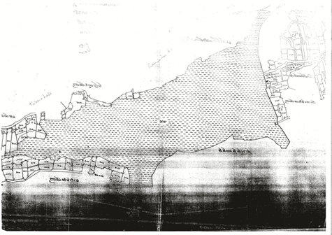
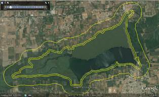
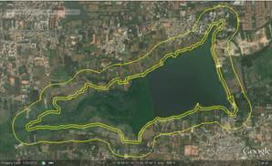
Varthur Lake: Area of the lake 190 Hectares (471.43 acre) – Figure 4.1: cadastral map of the study region, Area of Lake as per BDA 180.3 Hectares (445.35 acre)
Figure 4.1: Varthur Lake Cadastral Map
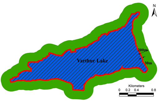
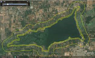
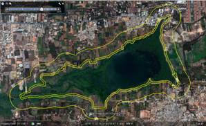
Figure 4.2: Varthur Lake and Buffer zones (30 m as per BDA and 200m as per MoEF, 2010- Wetlands regulatory framework)
City Development Plan: ‘NO DEVELOPMENT ZONES’ as per CDP 2005, 2015 include lakes, valleys, tanks and national parks and forests is proposed to preserve natural areas. Figure 4.3 depicts CDP for Bangalore indicating zones for conservation as well as for development. Figure 4.4 delineates valley zone in Bellandur-Varthur Valley.
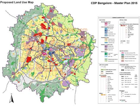
Figure 4.3: CDP 2015 Bangalore
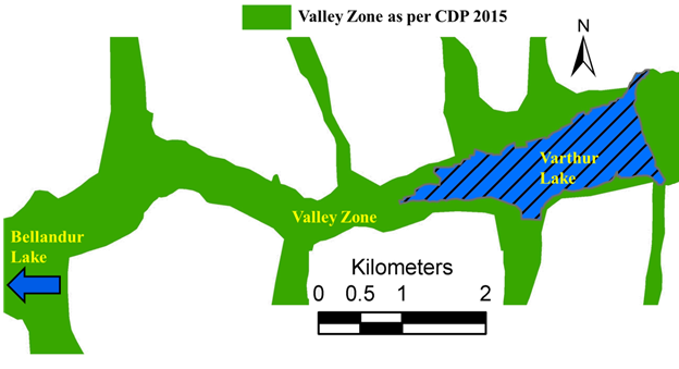
Figure 4.4: Valley Zone as per the City Development Plan 2015
Landscape dynamics in the Lake and buffer zone
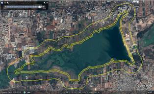
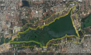
Drainage network and Land cover of the wetland region were mapped using temporal Google earth (http://www.googleearth.com) for the period 2003 to 2015, and the changes in landuse and drainages (network as well as width of the channel/drain). Figure 4.5 depicts drastic land use changes evident from the conversion of wetland to other land uses during 2003 to 2015 in the valley and buffer zone.
 |
|
2003 |
2004 |
|
|
2008 |
2009 |
|
|
2010 |
2011 |
|
|
2012 |
2013 |
|
|
2014 |
2015 |
Figure 4.5: Landscape dynamics in the valley and buffer zone
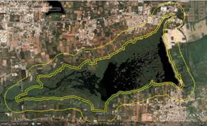
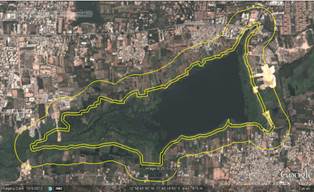
Encroachment of Lake bed: Lake has an area of 190 Hectares as per cadastral map (180 hectares as per BDA). Figure 4.6 maps prohibited activities in the lake bed -construction of roads, buildings, agricultural and horticulture activities. Total area under encroachment is 12.4 Hectares (30.64 Acres).
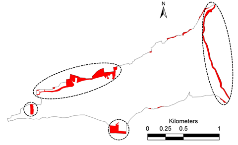
Figure 4.6: Encroachment of Lake
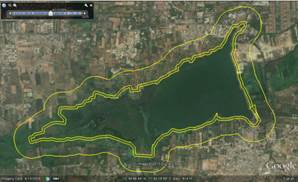
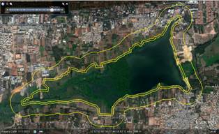
Construction activities in 30 m buffer: Area under Construction activities and Buildings 4.46 Hectares (11.09 Acre)
Figure 4.7: Construction activities 30 m buffer as per BDA
Construction activities in 200 m buffer: Figure 4.8 maps area under construction and buildings 49.53 Hectares (1122.40 Acre) in 200 m buffer zone (no building activities as per wetlands regulatory framework 2010). Figure 4.9a summaries violations in lake bed as well as in buffer zones. Figures 4.9b to 4.9f depicts section wise land use violations in the region.
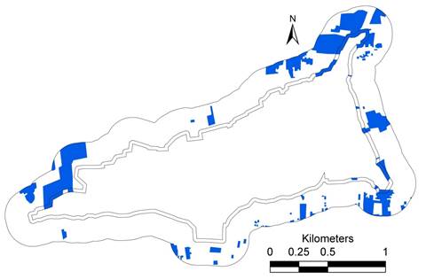
Figure 4.8 Construction activities 200m buffer as per MoEF
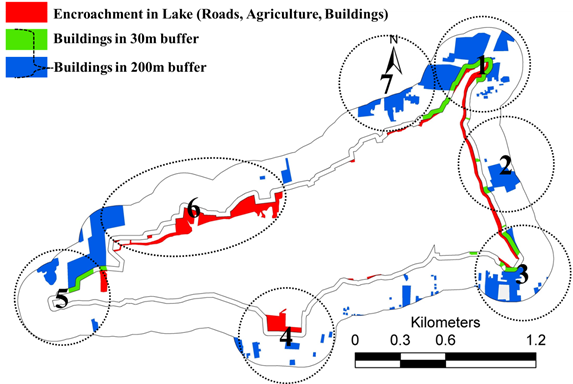
Figure 4.9a: Encroachments and Law violations in the lake and buffer zones
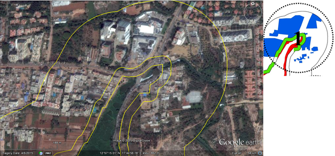
Figure 4.9b: Encroachments and Law violations at Section 1
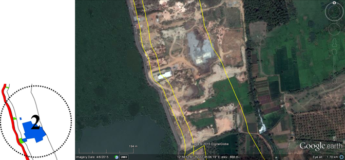
Figure 4.9c: Encroachments and Law violations at Section 2
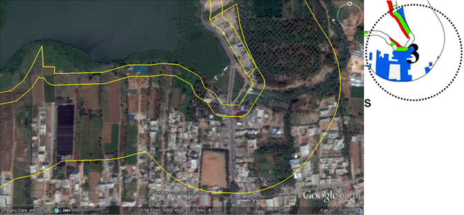
Figure 4.9c: Encroachments and Law violations at Section 3
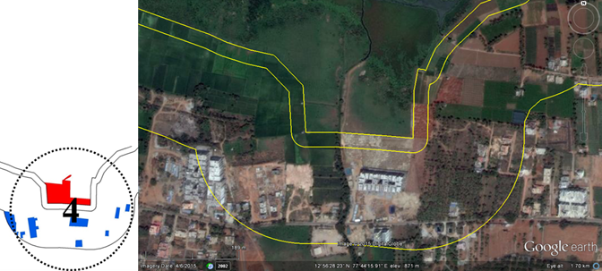
Figure 4.9d: Encroachments and Law violations at Section 4
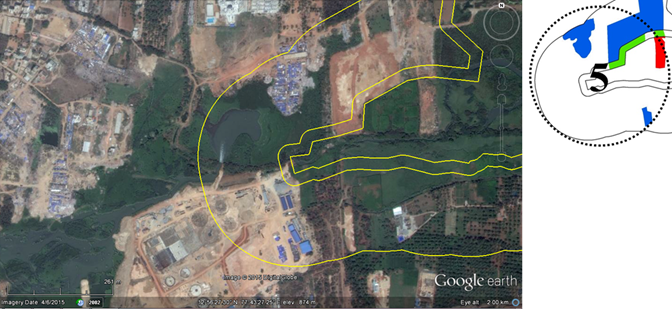
Figure 4.9e: Encroachments and Law violations at Section 5
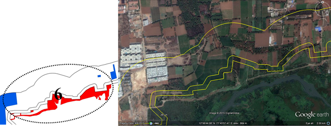
Figure 4.9f: Encroachments and Law violations at Section 6
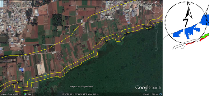
Figure 4.9g: Encroachments and Law violations at Section 7
City Development Plan: As per the CDP, valley zones and the lakes need to be completely protected (Figure 4.10a), whereas large scale construction activities have degradation of valley zone. Area under altered valley zone (including STP) is 559.25Hectares (1381.93 acres). Figure 4.10b to 4.10e depicts temporal increase in violations / illegal construction activities in the valley zone during 2003 to 2015.
Loss of storm water drains: figures 4.11 to 4.13 depicts encroachment of stormwater drains in Varthur lake downstream.
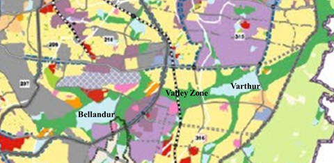
Figure 4.10a: CDP indicating protected zones
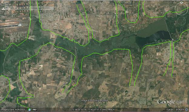
Figure 4.10b: Valley Zone 2003
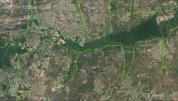
Figure 4.10c: Valley Zone 2009
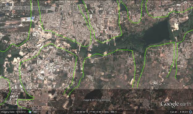
Figure 4.10d: Valley Zone 2012
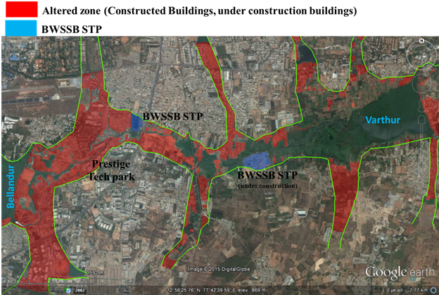
Figure 4.10e: Valley Zone 2015
Major violations:
- Development in the wetland - Violation of CDP 2015 as valley zone is supposed to be protected as the region is “No Development Zone”;
- Encroachment of wetlands in the valley region: Wetlands removal affects the ecological functioning. Wetlands with numerous aquatic plants in the valley of Bellandur-Varthur were treating water through uptake of nutrient and heavy metals (bioremediation);
- These violations or construction activities activity enchases flooding in the vicinity due to
- Encroachment of drains / rajakaluves;
- Alterations in topography;
- Encroachment of lakebed; and
- Encroaching of lake itself by dumping debris and filling up of same
- Construction activity in the lake floodplain;
- Violation of 30 m buffer (lake floodplain);
- Encroachment of a drains and lake bed;
- Filling of a portion of lake with building debris
- Removal of fence and systematic encroachment of lake bed through dumping of building debris.
Citizens of Bangalore allowed the development in the region with “utmost good faith”. But, numerous para-state agencies with un-coordinated actions, inefficient regulatory agency and negligent industries have converted the garden city to unlivable city.
- Contaminated air, land and water are the penalty citizens have to pay for exercising tolerance with good faith.
- Growth in Bangalore has surpassed the threshold evident from stress on supportive capacity (insufficient water, clean air and water, inadequate electricity, traffic bottlenecks, etc.) and assimilative capacity (polluted water and sediments in water bodies, enhanced GHG – Greenhouse gases, etc.)
- There has been a 925% increase in built up area (concretisation, paved surfaces) in Bangalore from 1973 to 2013 with a sharp decline of 79% area in water bodies affecting the micro-climate, water availability, etc..
- Higher level of GHGs (Greenhouse gases) in the air environment, nutrient and heavy metal rich water bodies and land, highlight the penalty to be paid for allowing unplanned urbanisation.
Solution is “Decongest and decontaminate Bangalore”
so that at least next generation enjoys better environment in Bangalore
- Need to ensure the ecosystem integrity to sustain goods and services for maintaining inter-generation equity.
Clean air, water and environment are the fundamental rights of citizens as per the Constitution of India (Article-21 of the Indian Constitution)
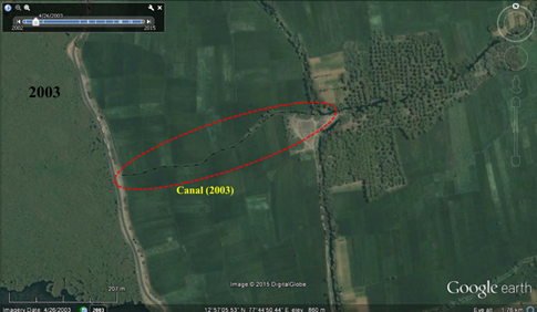
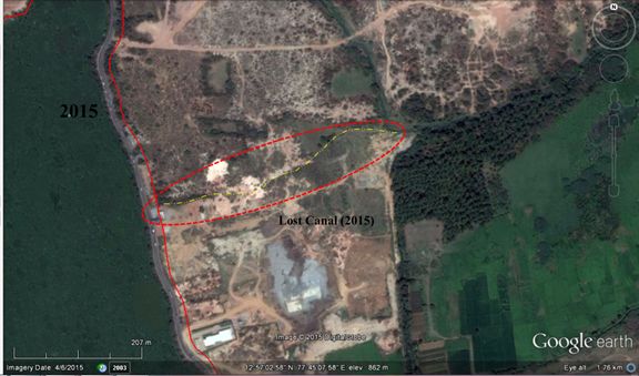
Figure 4.11: Encroached drains at downstream of Varthur Lake
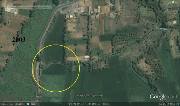
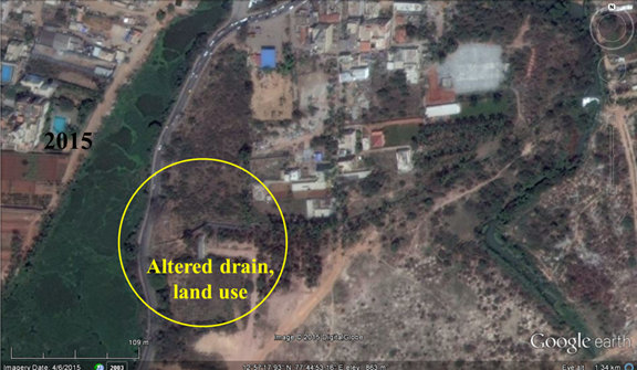
Figure 4.12: Encroached canal and altered land use downstream of Varthur Lake
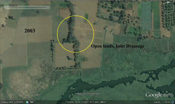
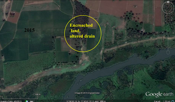
Figure 4.13: Encroached canal and altered land use upstream of Varthur Lake