


Landsat 8 launched on February 11, 2013, from Vandenberg Air Force Base, California, on an Atlas-V 401 rocket, with the extended payload fairing (EPF) from United Launch Alliance, LLC. (The Landsat 8 Launch in Quotes.) The Landsat 8 satellite payload consists of two science instruments—the Operational Land Imager (OLI) and the Thermal Infrared Sensor (TIRS). These two sensors provide seasonal coverage of the global landmass at a spatial resolution of 30 meters (visible, NIR, SWIR); 100 meters (thermal); and 15 meters (panchromatic). Landsat 8 was developed as a collaboration between NASA and the U.S. Geological Survey (USGS). NASA led the design, construction, launch, and on-orbit calibration phases, during which time the satellite was called the Landsat Data Continuity Mission (LDCM). On May 30, 2013, USGS took over routine operations and the satellite became Landsat 8. USGS leads post-launch calibration activities, satellite operations, data product generation, and data archiving at the Earth Resources Observation and Science (EROS) center.
Evolutionary Advances
Landsat 8 instruments represent an evolutionary advance in technology. OLI improves on past Landsat sensors using a technical approach demonstrated by a sensor flown on NASA’s experimental EO-1 satellite. OLI is a push-broom sensor with a four-mirror telescope and 12-bit quantization. OLI collects data for visible, near infrared, and short wave infrared spectral bands as well as a panchromatic band. It has a five-year design life. The graphic below compares the OLI spectral bands to Landsat 7′s ETM+ bands. OLI provides two new spectral bands, one tailored especially for detecting cirrus clouds and the other for coastal zone observations.
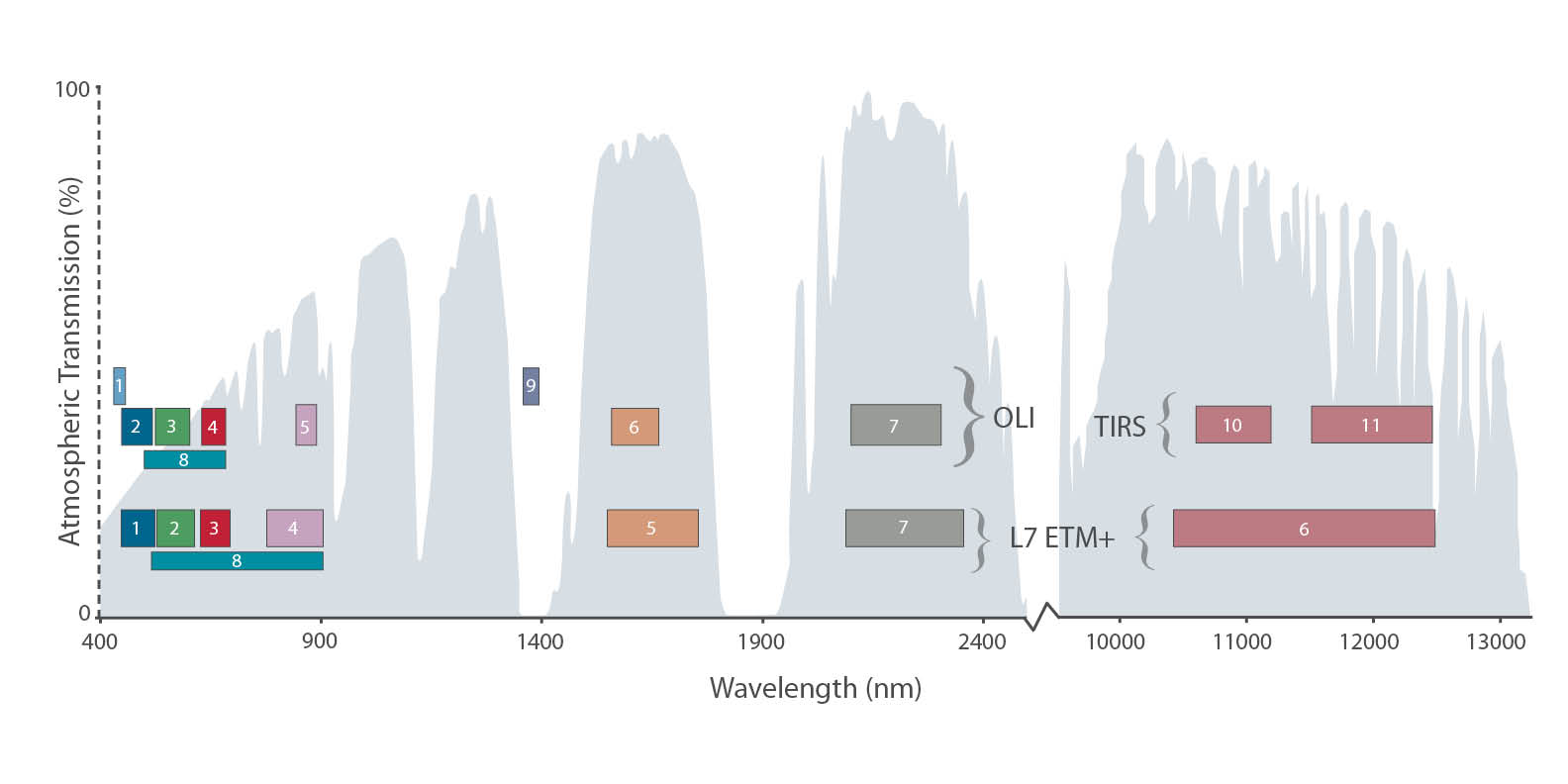
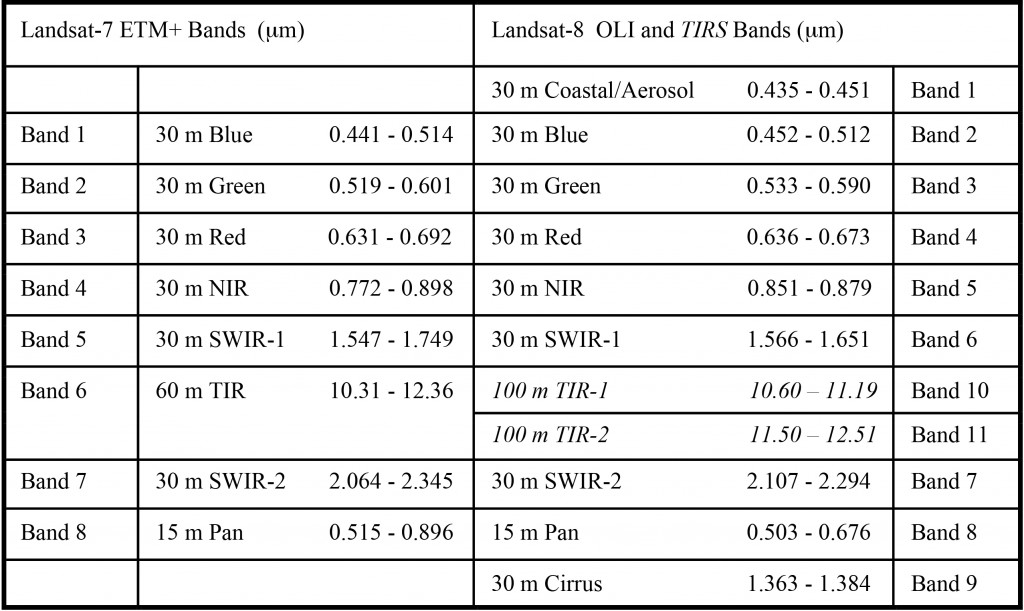
TIRS collects data for two more narrow spectral bands in the thermal region formerly covered by one wide spectral band on Landsats 4–7. The 100 m TIRS data is registered to the OLI data to create radiometrically, geometrically, and terrain-corrected 12-bit data products. Landsat 8 is required to return 400 scenes per day to the USGS data archive (150 more than Landsat 7 is required to capture). Landsat 8 has been regularly acquiring 725 scenes per day (and Landsat 7 is acquiring 438 scenes per day). This increases the probability of capturing cloud-free scenes for the global landmass. The Landsat 8 scene size is 185-km-cross-track-by-180-km-along-track. The nominal spacecraft altitude is 705 km. Cartographic accuracy of 12 m or better (including compensation for terrain effects) is required of Landsat 8 data products.
More About Landsat 8
![]()
- Picturing a Pixel (news brief & graphic)
- Landsat 8 Lunar Calibration (includes sample data)
- Landsat 8 Bands
- Landsat 8 Orbital Swath
- NASA Landsat 8 website
- USGS Landsat website
- Download LDCM Launch Brochure (PDF, 18.2 Mb)
- LDCM Communications Toolkit (for Mac: 200.5 Mb; for PC: 227.5 Mb)
More History
More Technical Details